
Maryland Route 341
Encyclopedia
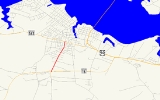
Maryland Route 341 is a state highway
in the U.S. state
of Maryland
. Known as Race Street, the state highway runs 1.25 miles (2 km) from MD 16
north to MD 343
within the city of Cambridge
. The part of Race Street that is now MD 341 was constructed in the mid 1910s as one of the original state roads and designated MD 16 in 1927. MD 341 was assigned to the road after MD 16 bypassed Cambridge in the 1960s.
. Maple Dam Road heads south toward Blackwater National Wildlife Refuge
and MD 16 heads east on a bypass of Cambridge toward U.S. Route 50
(US 50). MD 341 heads north, passing through fields before transitioning to residential subdivisions and then residential neighborhoods as the highway approaches the center of Cambridge. The state highway reaches its northern terminus at an intersection with MD 343 (Washington Street). Race Street continues north toward downtown Cambridge as a municipal street.
in Dorchester County
.
{|class=wikitable
!Mile
!Destinations
!Notes
|-
|rowspan=2|0.00
|Maple Dam Road south – Blackwater National Wildlife Refuge
|rowspan=2|Southern terminus
|-
|
|-
|rowspan=2|1.25
|
|rowspan=2|Northern terminus
|-
|Race Street north – Downtown Cambridge
State highway
State highway, state road or state route can refer to one of three related concepts, two of them related to a state or provincial government in a country that is divided into states or provinces :#A...
in the U.S. state
U.S. state
A U.S. state is any one of the 50 federated states of the United States of America that share sovereignty with the federal government. Because of this shared sovereignty, an American is a citizen both of the federal entity and of his or her state of domicile. Four states use the official title of...
of Maryland
Maryland
Maryland is a U.S. state located in the Mid Atlantic region of the United States, bordering Virginia, West Virginia, and the District of Columbia to its south and west; Pennsylvania to its north; and Delaware to its east...
. Known as Race Street, the state highway runs 1.25 miles (2 km) from MD 16
Maryland Route 16
Maryland Route 16 is a state highway in the U.S. state of Maryland. The state highway runs from Taylors Island east to the Delaware state line in Hickman, where the highway continues as Delaware Route 16...
north to MD 343
Maryland Route 343
Maryland Route 343 is a state highway in the U.S. state of Maryland. Known for most of its length as Hudson Road, the state highway runs from Hudson in northwestern Dorchester County east to U.S. Route 50 in Cambridge. MD 343 was paved in the late 1920s and early 1930s...
within the city of Cambridge
Cambridge, Maryland
Cambridge is a city in Dorchester County, Maryland, United States. The population was 12,326 at the 2010 census. It is the county seat of Dorchester County and the county's largest municipality...
. The part of Race Street that is now MD 341 was constructed in the mid 1910s as one of the original state roads and designated MD 16 in 1927. MD 341 was assigned to the road after MD 16 bypassed Cambridge in the 1960s.
Route description
MD 341 begins at an intersection with MD 16 (Church Creek Road) and Maple Dam Road near the southern edge of the city of Cambridge adjacent to Cambridge-South Dorchester High SchoolCambridge-South Dorchester High School
Cambridge-South Dorchester High School is located in Cambridge, Maryland and is part of the Dorchester County Public Schools system, and serves students in grades 9 to 12. The School opened in 1976 and cost $9 Million Dollars to build and equip. The school's most prominent feature is that it was...
. Maple Dam Road heads south toward Blackwater National Wildlife Refuge
Blackwater National Wildlife Refuge
The Blackwater National Wildlife Refuge was established in 1933 as a waterfowl sanctuary for birds migrating along the critical migration highway called the Atlantic Flyway...
and MD 16 heads east on a bypass of Cambridge toward U.S. Route 50
U.S. Route 50 in Maryland
U.S. Route 50 is a major east–west route of the U.S. Highway system, stretching just over from Ocean City, Maryland on the Atlantic Ocean to West Sacramento, California. In the U.S. state of Maryland, US 50 exists in two sections. The longer of these serves as a major route connecting...
(US 50). MD 341 heads north, passing through fields before transitioning to residential subdivisions and then residential neighborhoods as the highway approaches the center of Cambridge. The state highway reaches its northern terminus at an intersection with MD 343 (Washington Street). Race Street continues north toward downtown Cambridge as a municipal street.
History
Race Street south of Washington Street was included as part of the Cambridge–Church Creek highway designated for improvement as a state road by the Maryland State Roads Commission in 1909. That 6 miles (9.7 km) highway was completed in 1915. The highway was designated part of MD 16, along with Washington Street east toward East New Market, in 1927. When MD 16 was rerouted to bypass Cambridge in 1967, MD 341 was assigned to the Race Street portion of the bypassed route.Junction list
The entire route is in CambridgeCambridge, Maryland
Cambridge is a city in Dorchester County, Maryland, United States. The population was 12,326 at the 2010 census. It is the county seat of Dorchester County and the county's largest municipality...
in Dorchester County
Dorchester County, Maryland
Dorchester County is a county located in the U.S. state of Maryland on its Eastern Shore. It is bordered by the Choptank River to the north, Talbot County to the northwest, Caroline County to the northeast, Wicomico County to the southeast, Sussex County, Delaware, to the east, and the Chesapeake...
.
{|class=wikitable
!Mile
!Destinations
!Notes
|-
|rowspan=2|0.00
|Maple Dam Road south – Blackwater National Wildlife Refuge
Blackwater National Wildlife Refuge
The Blackwater National Wildlife Refuge was established in 1933 as a waterfowl sanctuary for birds migrating along the critical migration highway called the Atlantic Flyway...
|rowspan=2|Southern terminus
|-
|
|-
|rowspan=2|1.25
|
|rowspan=2|Northern terminus
|-
|Race Street north – Downtown Cambridge