

Araguaia River
Encyclopedia
The Araguaia River or, in Portuguese, Rio Araguaia is one of the major rivers of Brazil
, and the principal tributary of the Tocantins
. It has a total length of approximately 2,627 km. Araguaia means "river of (red) macaws" in the Tupi language.
as well in the Divisões mountain range situated in Goiás
(according to other sources however, the Araguaia comes from the Caiapó Range, at the Goiás-Mato Grosso border). From there it flows northeast to a junction with the Tocantins
near the town of São João.
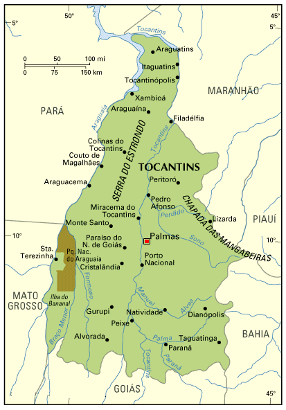
Along its course, the river forms the border between the Brazilian federal states of Goiás
, Mato Grosso
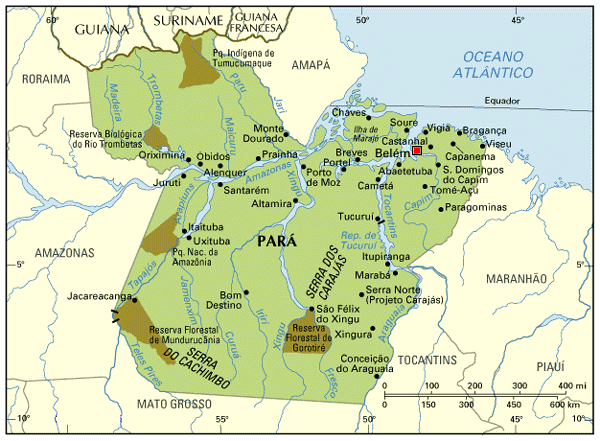
, Tocantins and Pará
. Roughly in the middle of its course, the Araguaia splits into two forks (with the western one retaining the name Araguaia and the eastern one being called Rio Javaés). These later reunite, forming the Ilha do Bananal, the world's largest river island. The mouth of the Javaés forms a broad inland delta where it pours back into the main Araguaia, a 100,000 hectare expanse of igapó flooded forest, blackwater river channels, and oxbow lakes called Cantão
. This is one of the biologically richest areas of the eastern Amazon, with over 700 species of birds, nearly 300 species of fish (more than in all of Europe), and large populations of threatened species such as the giant otter
, the black cayman, and the world's largest freshwater fish, the pirarucú, all occurring within a relatively small area.
A large portion of the Araguaia's course is navigable all year, but the river below the Cantão wetlands is interrupted by rapids.
The combined watershed of Araguaia and Tocantins rivers (named the Araguaia Tocantins Basin) covers approximately 9.5 % of Brazil's national territory. This area is an integral part of the Amazon Basin
. However, the Araguaia River is not a tributary of the Amazon.
"Araguaia" means "River of the Macaw
s" in the native Tupi language.
, which rises in the Serra de São Jerônimo, near Cuiabá
, Mato Grosso, and is navigable to Pará
.
Other important tributaries include the Bonito, Garcas, Cristallino and Tapirape
on the west, and the Pitombas, Claro
, Vermelho, Tucupa and Chavante on the east.
and the Araguaia National Park
. The Araguaia has "beaches" - bright sandy banks that seam the stream from May to October.
Brazil
Brazil , officially the Federative Republic of Brazil , is the largest country in South America. It is the world's fifth largest country, both by geographical area and by population with over 192 million people...
, and the principal tributary of the Tocantins
Tocantins River
The Tocantins is a river in Brazil, the central fluvial artery of the country. In the Tupi language, its name means "toucan's beak" . It runs from south to north for about 2,640 km. It is not really a branch of the Amazon River, although usually so considered, since its waters flow into the...
. It has a total length of approximately 2,627 km. Araguaia means "river of (red) macaws" in the Tupi language.
Geography
Because of the vast number of tributaries, it is not easy to define its source. Important tributaries originate in the Araras mountain range in Mato GrossoMato Grosso
Mato Grosso is one of the states of Brazil, the third largest in area, located in the western part of the country.Neighboring states are Rondônia, Amazonas, Pará, Tocantins, Goiás and Mato Grosso do Sul. It also borders Bolivia to the southwest...
as well in the Divisões mountain range situated in Goiás
Goiás
Goiás is a state of Brazil, located in the central part of the country. The name Goiás comes from the name of an indigenous community...
(according to other sources however, the Araguaia comes from the Caiapó Range, at the Goiás-Mato Grosso border). From there it flows northeast to a junction with the Tocantins
Tocantins River
The Tocantins is a river in Brazil, the central fluvial artery of the country. In the Tupi language, its name means "toucan's beak" . It runs from south to north for about 2,640 km. It is not really a branch of the Amazon River, although usually so considered, since its waters flow into the...
near the town of São João.
Along its course, the river forms the border between the Brazilian federal states of Goiás
Goiás
Goiás is a state of Brazil, located in the central part of the country. The name Goiás comes from the name of an indigenous community...
, Mato Grosso
Mato Grosso
Mato Grosso is one of the states of Brazil, the third largest in area, located in the western part of the country.Neighboring states are Rondônia, Amazonas, Pará, Tocantins, Goiás and Mato Grosso do Sul. It also borders Bolivia to the southwest...
, Tocantins and Pará
Pará
Pará is a state in the north of Brazil. It borders the Brazilian states of Amapá, Maranhão, Tocantins, Mato Grosso, Amazonas and Roraima. To the northwest it also borders Guyana and Suriname, and to the northeast it borders the Atlantic Ocean. The capital is Belém.Pará is the most populous state...
. Roughly in the middle of its course, the Araguaia splits into two forks (with the western one retaining the name Araguaia and the eastern one being called Rio Javaés). These later reunite, forming the Ilha do Bananal, the world's largest river island. The mouth of the Javaés forms a broad inland delta where it pours back into the main Araguaia, a 100,000 hectare expanse of igapó flooded forest, blackwater river channels, and oxbow lakes called Cantão
Cantão
Cantão is a tropical forest ecosystem located in the central Araguaia river basin, the southeastern edge of the Amazon biome, in the Brazilian state of Tocantins...
. This is one of the biologically richest areas of the eastern Amazon, with over 700 species of birds, nearly 300 species of fish (more than in all of Europe), and large populations of threatened species such as the giant otter
Giant Otter
The giant otter is a South American carnivorous mammal. It is the longest member of the Mustelidae, or weasel family, a globally successful group of predators. Unusually for a mustelid, the giant otter is a social species, with family groups typically supporting three to eight members...
, the black cayman, and the world's largest freshwater fish, the pirarucú, all occurring within a relatively small area.
A large portion of the Araguaia's course is navigable all year, but the river below the Cantão wetlands is interrupted by rapids.
The combined watershed of Araguaia and Tocantins rivers (named the Araguaia Tocantins Basin) covers approximately 9.5 % of Brazil's national territory. This area is an integral part of the Amazon Basin
Amazon Basin
The Amazon Basin is the part of South America drained by the Amazon River and its tributaries that drains an area of about , or roughly 40 percent of South America. The basin is located in the countries of Bolivia, Brazil, Colombia, Ecuador, Guyana, Peru, and Venezuela...
. However, the Araguaia River is not a tributary of the Amazon.
"Araguaia" means "River of the Macaw
Macaw
Macaws are small to large, often colourful New World parrots. Of the many different Psittacidae genera, six are classified as macaws: Ara, Anodorhynchus, Cyanopsitta, Primolius, Orthopsittaca, and Diopsittaca...
s" in the native Tupi language.
Tributaries
Its principal tributary is the Rio das MortesRio das Mortes
The Rio das Mortes is a river of Mato Grosso state in western Brazil. It has a length of 278 km.-References:*...
, which rises in the Serra de São Jerônimo, near Cuiabá
Cuiabá
Under the Koppen climate classification, Cuiaba features a tropical wet and dry climate. Cuiabá is famous for its searing heat, although temperatures in winter can arrive sporadically at 10 degrees, indeed atypical, caused by cold fronts coming from the south, and that may only last one or two...
, Mato Grosso, and is navigable to Pará
Pará
Pará is a state in the north of Brazil. It borders the Brazilian states of Amapá, Maranhão, Tocantins, Mato Grosso, Amazonas and Roraima. To the northwest it also borders Guyana and Suriname, and to the northeast it borders the Atlantic Ocean. The capital is Belém.Pará is the most populous state...
.
Other important tributaries include the Bonito, Garcas, Cristallino and Tapirape
Tapirapé River (Mato Grosso)
-References:*...
on the west, and the Pitombas, Claro
Claro River (Araguaia River)
-References:*...
, Vermelho, Tucupa and Chavante on the east.
History
It was explored in part by Henri Coudreau in 1897. From 1972 to 1974 this region was the scene of conflict between left-wing guerrilla movements and forces supporting the then military dictatorship.Towns
Among the most important settlements on the banks of the Araguaia River are (in a downstream order):- Barra do GarçasBarra do GarçasBarra do Garças is a city with a population of 50,000 located in the Brazilian state of Mato Grosso, around far from the capital city of Cuiabá...
- AragarçasAragarçasAragarças is a small town and municipality in southwest Goiás state, Brazil.-Location:Aragarças is the most important town in the Aragarças Microregion. It is 410 km...
- AruanãAruanãAruanã is a small town and municipality in north-western Goiás state, Brazil. It has a total area of 3,050.3 km², with a population of 6,476 in 2007. Aruanã is a tourist spot on the Araguaia River and is a major producer of cattle.-Location:...
- Luiz AlvesLuiz AlvesLuiz Alves is a town and municipality in the state of Santa Catarina in the South region of Brazil.-References:...
- São Félix do AraguaiaSão Félix do AraguaiaSão Félix do Araguaia is a town and municipality in the state of Mato Grosso in the Central-West Region of Brazil.The city is served by São Félix do Araguaia Airport.-References:...
- Santa Terezinha
- AraguacemaAraguacemaAraguacema is a municipality located in the Brazilian state of Tocantins. Its population was 6,000 and its area is 2,778 km²....
- Conceição do AraguaiaConceição do AraguaiaConceição do Araguaia is a town and municipality in the state of Pará in the Northern region of Brazil.The city is served by Conceição do Araguaia Airport.-References:...
- XambioáXambioáThe Xambioá, also called the Karajá do Norte, Ixybiowa, or Iraru Mahãndu, are an indigenous people who live in Tocantins, Brazil. The size of the present-day population does not reflect what it had been up to the end of the 19th Century, when the Karajá do Norte numbered some 1,350 individuals...
- São Geraldo do AraguaiaSão Geraldo do AraguaiaSão Geraldo do Araguaia is a town and municipality in the state of Pará in the Northern region of Brazil.-References:...
- São João do AraguaiaSão João do AraguaiaSão João do Araguaia is a town and municipality in the state of Pará in the Northern region of Brazil.-References:...
Tourism
Several parts of the river's course are protected by national parks and other reserves like the Emas National ParkEmas National Park
The Emas National Park |Rhea]] National Park") is a national park and a UNESCO World Heritage Sitein the states of Goiás and Mato Grosso do Sul in Brazil.-Description:...
and the Araguaia National Park
Araguaia National Park
The Araguaia National Park is located in Tocantins state in the north of Brazil, between 09º51’—11º11’S and 49º57’—50º27’W.-External links:*...
. The Araguaia has "beaches" - bright sandy banks that seam the stream from May to October.
External links
- Rio Araguaia (information for tourists in Portuguese, Spanish and English)
- Hotel, turismo, pescaria, passeios ecológicos Araguaia,Luiz Alves, Bananal, Cristalino
- hydrographic information (in Portuguese)
- Basin map (in Portuguese)
- Tocantins state, with Rivers v-Brazil.com
- Pará state, with Rivers v-Brazil.com
- Instituto Araguaia
- Brazilian Ministry of Transport