
List of bridges on the National Register of Historic Places in Colorado
Encyclopedia
This is a list of bridge
s and tunnel
s on the National Register of Historic Places
in the U.S. state
of Colorado
.
Bridge
A bridge is a structure built to span physical obstacles such as a body of water, valley, or road, for the purpose of providing passage over the obstacle...
s and tunnel
Tunnel
A tunnel is an underground passageway, completely enclosed except for openings for egress, commonly at each end.A tunnel may be for foot or vehicular road traffic, for rail traffic, or for a canal. Some tunnels are aqueducts to supply water for consumption or for hydroelectric stations or are sewers...
s on the National Register of Historic Places
National Register of Historic Places
The National Register of Historic Places is the United States government's official list of districts, sites, buildings, structures, and objects deemed worthy of preservation...
in the U.S. state
U.S. state
A U.S. state is any one of the 50 federated states of the United States of America that share sovereignty with the federal government. Because of this shared sovereignty, an American is a citizen both of the federal entity and of his or her state of domicile. Four states use the official title of...
of Colorado
Colorado
Colorado is a U.S. state that encompasses much of the Rocky Mountains as well as the northeastern portion of the Colorado Plateau and the western edge of the Great Plains...
.
| Name | Image | Built | Listed | Location | County | Type |
|---|---|---|---|---|---|---|
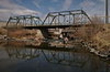
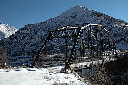
| 19th Street Bridge 19th Street Bridge 19th Street Bridge is a 2-span truss road bridge in Denver, Colorado over the South Platte River, now used for pedestrians. Vehicular traffic now uses a bridge downstream, directly to the northeast.-External links:****... |
 |
1888 | 1985-02-04 | Denver Denver, Colorado The City and County of Denver is the capital and the most populous city of the U.S. state of Colorado. Denver is a consolidated city-county, located in the South Platte River Valley on the western edge of the High Plains just east of the Front Range of the Rocky Mountains... 39°45′36"N 105°0′12"W |
Denver | 2-span Pratt Through Truss |
| Alpine Tunnel Historic District | 1879, 1881, 1910 | 1996-04-01 | Hancock, Pitkin Pitkin, Colorado Pitkin is a Statutory Town in Gunnison County, Colorado, United States. The population was 66 at the 2010 census.-Geography:Pitkin is located at .... , Quartz |
Chaffee Chaffee County, Colorado Chaffee County is one of the 64 counties of the state of Colorado of the United States. The county population was 16,242 at U.S. Census 2000. The county seat is Salida.-History:... , Gunnison Gunnison County, Colorado Gunnison County is the fifth most extensive of the 64 counties of the state of Colorado in the United States. The county population was 15,324 at the 2010 census. The county was named for John W. Gunnison, a United States Army officer and captain in the Army Topographical Engineers, who surveyed... |
||
| Argo Tunnel and Mill | 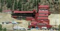 |
1893 | 1978-01-31 | Idaho Springs Idaho Springs, Colorado The City of Idaho Springs is a municipality in the U.S. state of Colorado that is the most populous settlement in Clear Creek County, Colorado. Idaho Springs is located in Clear Creek Canyon, in the mountains upstream from Golden, some thirty miles west of Denver... |
Clear Creek Clear Creek County, Colorado Clear Creek County is one of the 64 counties of the state of Colorado of the United States. The county population was 9,322 at U.S. Census 2000. The county seat is Georgetown... |
|
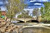
| Arkansas River Bridge |  |
1937 | 1985-02-04 | Buena Vista Buena Vista, Colorado Buena Vista is a Statutory Town in Chaffee County, Colorado, United States. The population was 2,195 at the 2000 census.Buena Vista is located in central Colorado roughly midway between Salida and Leadville in the Upper Arkansas River Valley at an elevation of . The area between Buena Vista and... 38°48′49"N 106°6′12"W |
Chaffee Chaffee County, Colorado Chaffee County is one of the 64 counties of the state of Colorado of the United States. The county population was 16,242 at U.S. Census 2000. The county seat is Salida.-History:... |
Pratt Deck Truss |
| Avondale Bridge Avondale Bridge Avondale Bridge was located in Pueblo, Colorado. It is currently listed on the National Historic Register of Places. It was a Luten Arch bridge built by the Pueblo Bridge Co.. It was replaced in 2005.... |
 |
1913 | 1985-02-04 | Avondale Avondale, Colorado Avondale is a census-designated place in Pueblo County, Colorado, United States. It is part of the Pueblo Metropolitan Statistical Area. The population was 674 at the 2010 census... 38°14′32"N 104°20′54"W |
Pueblo Pueblo County, Colorado Pueblo County is the tenth most populous of the 64 counties of the state of Colorado of the United States. The county was named for the historic city of Pueblo which took its name from the Spanish language word meaning "town" or "village". The United States Census Bureau estimates that the... |
Luten Arch |
| Big Thompson River Bridge III | 2002-10-15 | Loveland Loveland, Colorado Loveland is a Home Rule Municipality that is the second most populous city in Larimer County, Colorado, United States. Loveland is situated north of the Colorado State Capitol in Denver. Loveland is the 14th most populous city in Colorado. The United States Census Bureau that in 2010 the... 40°24′54"N 105°11′42"W |
Larimer Larimer County, Colorado Larimer County is the seventh most populous and the ninth most extensive of the 64 counties of the State of Colorado of the United States. The county is located at the northern end of the Front Range, at the edge of the Colorado Eastern Plains along the border with Wyoming... |
Camelback pony truss | ||
| Big Thompson River Bridge IV | 2002-10-15 | Loveland Loveland, Colorado Loveland is a Home Rule Municipality that is the second most populous city in Larimer County, Colorado, United States. Loveland is situated north of the Colorado State Capitol in Denver. Loveland is the 14th most populous city in Colorado. The United States Census Bureau that in 2010 the... 40°25′7"N 105°10′47"W |
Larimer Larimer County, Colorado Larimer County is the seventh most populous and the ninth most extensive of the 64 counties of the State of Colorado of the United States. The county is located at the northern end of the Front Range, at the edge of the Colorado Eastern Plains along the border with Wyoming... |
Camelback pony truss | ||
| Black Squirrel Creek Bridge Black Squirrel Creek Bridge The Black Squirrel Creek Bridge is a Parker truss bridge in eastern El Paso County, Colorado. The bridge carries U.S. Route 24 across Black Squirrel Creek at the highway's milepost 327.33.-History:... |
 |
2002-10-15 | Falcom 39°0′12"N 104°30′46"W |
El Paso El Paso County, Colorado El Paso County is the most populous of the 64 counties of the state of Colorado of the United States, now more populous than Denver County. The United States Census Bureau concluded that the county population was 622,371 in 2010. In recent years, the population had come closer to that of Denver... |
Parker through truss | |
| Boulder Creek Bridge | 1953 | 2003-03-11 | Boulder Boulder, Colorado Boulder is the county seat and most populous city of Boulder County and the 11th most populous city in the U.S. state of Colorado. Boulder is located at the base of the foothills of the Rocky Mountains at an elevation of... 40°0′52"N 105°19′12"W |
Boulder Boulder County, Colorado Boulder County is the sixth most populous of the 64 counties of the state of Colorado of the United States. The county seat is Boulder. The most populous municipality in the county and the county seat is the City of Boulder... |
Concrete slab and girder | |
| Bridge No. 10/Adelaide Bridge | 1894 | 1985-02-04 | Florence Florence, Colorado The City of Florence is a Statutory City located in Fremont County, Colorado, United States. The population was 3,653 at the 2000 census.ADX Florence, the only federal Supermax prison in the United States, is located south of Florence in an unincorporated area in Fremont County... 38°34′17"N 105°5′10"W |
Fremont Fremont County, Colorado Fremont County is the thirteenth most populous of the 64 counties of the state of Colorado of the United States. The county is named for explorer and presidential candidate John C. Frémont. The county population was 46,824 at the 2010 census. The county seat is Cañon City. The Cañon City... |
Built-up Deck Girder bridge | |
| Bridge over Burro Canon | 1936 | 1985-02-04 | Madrid Madrid, Colorado Madrid is a ghost town in Las Animas County, Colorado, United States. It is east of the Front Range of the Rocky Mountains at an elevation of . The town is the west side of the county along Colorado State Highway 12, fourteen miles west of Trinidad. Madrid is named for the family that settled... 37°7′26"N 104°44′26"W |
Las Animas Las Animas County, Colorado Las Animas County has the largest area of the 64 counties of the State of Colorado of the United States. Las Animas County takes its name from the Mexican Spanish name of the Purgatoire River, originally called El Río de las Ánimas Perdidas en Purgatorio, which means "River of the Lost Souls in... |
Stone Multiplate Deck Arch | |
| Bridge over Fountain Creek | 1932 | 1985-02-04 | Manitou Springs Manitou Springs, Colorado The city of Manitou Springs is a Home Rule Municipality located in El Paso County, Colorado, United States. The population was 4,980 at the 2000 census.Students are served by Manitou Springs School District 14 and Manitou Springs High School.... 38°52′12"N 104°55′30"W |
El Paso El Paso County, Colorado El Paso County is the most populous of the 64 counties of the state of Colorado of the United States, now more populous than Denver County. The United States Census Bureau concluded that the county population was 622,371 in 2010. In recent years, the population had come closer to that of Denver... |
Open Spandral Deck Arch | |
| Cherry Creek Bridge Cherry Creek Bridge The Cherry Creek Bridge is a concrete arch bridge spanning Cherry Creek near Franktown, Colorado. State Highway 83 runs atop it. It was built in 1948 by J.H.& N.M. Monaghan & Associates and is listed on the National Register of Historic Places... |
 |
2002-10-15 | Franktown Franktown, Colorado Franktown is a census-designated place in Douglas County, Colorado, in the United States. The population was 395 at the 2010 census. The Franktown Post Office has the ZIP Code 80116. Pike's Peak Grange No... 39°19′52"N 104°44′2"W |
Douglas Douglas County, Colorado Douglas County is the eighth most populous of the 64 counties of the state of Colorado, in the United States. The county is located midway between Colorado's two largest cities: Denver and Colorado Springs... |
Two-rib open-spandrel arch | |
| Colorado River Bridge |  |
2002-10-15 | De Beque De Beque, Colorado De Beque is a Statutory Town in Mesa County, Colorado, United States. It is part of the Grand Junction Metropolitan Statistical Area. The population was 504 at the 2010 census. The town consists of a small grid, including a historic downtown featuring a town hall, a tavern, and several commercial... 39°20′20"N 108°11′36"W |
Mesa Mesa County, Colorado Mesa County is the fourth most extensive and the eleventh most populous of the 64 counties of the state of Colorado in the United States. The county was named for the many large mesas in the area, including Grand Mesa. The county population was 146,723 at the 2010 United States Census. The... |
Parker through truss | |
| Costilla Crossing Bridge |  |
1892 | 1985-02-04 | Antonito Antonito, Colorado The Town of Antonito is a statutory town located in Conejos County, Colorado, United States. As of the 2000 census, the town's population was 873.-Geography:... 37°4′43"N 105°45′22"W |
Conejos Conejos County, Colorado Conejos County is one of the 64 counties of the State of Colorado in the United States. The county population was 8,400 at U.S. Census 2000. The county seat is the unincorporated town of Conejos.-History:... |
Thatcher Through Truss |
| Cottonwood Creek Bridge | 1923 | 2001-10-12 | Colorado Springs Colorado Springs, Colorado Colorado Springs is a Home Rule Municipality that is the county seat and most populous city of El Paso County, Colorado, United States. Colorado Springs is located in South-Central Colorado, in the southern portion of the state. It is situated on Fountain Creek and is located south of the Colorado... 38°55′43"N 104°48′35"W |
El Paso El Paso County, Colorado El Paso County is the most populous of the 64 counties of the state of Colorado of the United States, now more populous than Denver County. The United States Census Bureau concluded that the county population was 622,371 in 2010. In recent years, the population had come closer to that of Denver... |
cantilevered concrete girder | |
| D & RG Narrow Gauge Trestle D & RG Narrow Gauge Trestle The D & RG Narrow Gauge Trestle is a narrow gauge railroad trestle crossing of the Cimarron River, located near Cimarron, Colorado, United States... |
 |
1976-06-18 | Cimarron Cimarron, Colorado Cimarron is an unincorporated town and U.S. Post Office in Montrose County, Colorado, United States. The Cimarron Post Office has the ZIP Code 81220.... 38°27′2"N 107°36′8"W |
Montrose Montrose County, Colorado Montrose County is the 17th most populous of the 64 counties of the State of Colorado of the United States. The county population was 41,276 at U.S. Census 2010. The county was named for its county seat, the City of Montrose... |
Pratt truss | |
| Dolores River Bridge Dolores River Bridge The Dolores River Bridge is a through truss bridge spanning the Dolores River near Bedrock, Colorado. It carries State Highway 90 and is listed on the National Register of Historic Places .... |
 |
2002-10-15 | Bedrock Bedrock, Colorado Bedrock is an unincorporated town and U.S. Post Office in Montrose County, Colorado, United States. The ZIP Code of the Bedrock Post Office is 81411.-History:The town of Bedrock was established in 1883. The Bedrock Post Office opened on November 8, 1883... 38°18′38"N 108°53′9"W |
Montrose Montrose County, Colorado Montrose County is the 17th most populous of the 64 counties of the State of Colorado of the United States. The county population was 41,276 at U.S. Census 2010. The county was named for its county seat, the City of Montrose... |
Pennsylvania through truss | |
| Dotsero Bridge | 2002-10-15 | Dotsero Dotsero, Colorado - Volcano :Dotsero is built at the base of Colorado's most recently active volcano, the Dotsero Crater, which, according to the United States Geological Survey, erupted 4,140 years ago.... 39°38′57"N 107°3′47"W |
Eagle Eagle County, Colorado Eagle County is the thirteenth most populous of the 64 counties of the State of Colorado in the United States. The county is named for the Eagle River. The county population was 41,659 at U.S. Census 2000. The county seat is the Town of Eagle... |
Parker through truss | ||
| Douglas Crossing Bridge | 1936 | 1985-02-04 | Granada Granada, Colorado Granada is a Statutory Town in Prowers County, Colorado, United States. The population was 640 at the 2000 census.-Geography:Granada is located at .... 37°47′43"N 102°15′20"W |
Prowers Prowers County, Colorado Prowers County is one of the 64 counties of the State of Colorado of the United States. The county is named in honor of John W. Prowers, a leading pioneer in the lower Arkansas valley region. The county population was 14,483 at U.S. Census 2000... |
Stone Ashlar Filled Arch | |
| Eagle River Bridge | 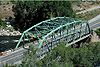 |
2002-10-15 | Eagle Eagle, Colorado Eagle is a Statutory Town in and the county seat of Eagle County, Colorado, United States. The population was 3,032 at the 2000 census.The town was made famous as the location of the Kobe Bryant sexual assault trial.-Demographics:... 39°39′36"N 106°48′55"W |
Eagle Eagle County, Colorado Eagle County is the thirteenth most populous of the 64 counties of the State of Colorado in the United States. The county is named for the Eagle River. The county population was 41,659 at U.S. Census 2000. The county seat is the Town of Eagle... |
Parker through truss | |
| F Street Bridge F Street Bridge (Salida, Colorado) The F Street Bridge in Salida, Colorado is a closed spandrel concrete arch bridge built in 1907 by the Pueblo Bridge Company. The design also known as a Luten Arch was patented in 1907 by Daniel Luten. The bridge with 2 spans and a total length of is believed to be the first bridge of this type... |
 |
1907 | 1985-02-04 | Salida Salida, Colorado The City of Salida is a Statutory City that is the county seat and most populous city of Chaffee County, Colorado, United States. The population was 5,504 at the U.S. Census 2000.-History:800px|thumb|left| Panoramic View of Salida, 1910... 38°32′16"N 105°59′33"W |
Chaffee Chaffee County, Colorado Chaffee County is one of the 64 counties of the state of Colorado of the United States. The county population was 16,242 at U.S. Census 2000. The county seat is Salida.-History:... |
Luten Arch |
| Fruita Bridge | 1906 | 1985-02-04 | Fruita Fruita, Colorado The City of Fruita is a Home Rule Municipality located in the western part of Mesa County, Colorado, in the United States. It is part of the Grand Junction Metropolitan Statistical Area and within the Grand Valley... 39°8′13"N 108°43′50"W |
Mesa Mesa County, Colorado Mesa County is the fourth most extensive and the eleventh most populous of the 64 counties of the state of Colorado in the United States. The county was named for the many large mesas in the area, including Grand Mesa. The county population was 146,723 at the 2010 United States Census. The... |
Parker Through Truss | |
| Granada Bridge | 2002-10-15 | Granada Granada, Colorado Granada is a Statutory Town in Prowers County, Colorado, United States. The population was 640 at the 2000 census.-Geography:Granada is located at .... 38°5′38"N 102°18′37"W |
Prowers Prowers County, Colorado Prowers County is one of the 64 counties of the State of Colorado of the United States. The county is named in honor of John W. Prowers, a leading pioneer in the lower Arkansas valley region. The county population was 14,483 at U.S. Census 2000... |
Steel I-beam stringer | ||
| Gunnison River Bridge I | 2002-10-15 | Gunnison Gunnison, Colorado The historic City of Gunnison, a Home Rule Municipality, is the county seat and the most populous city of Gunnison County, Colorado, United States. As of the 2010 census, the city had a population of 5,854. It was named in honor of John W... 38°31′58"N 106°57′6"W |
Gunnison Gunnison County, Colorado Gunnison County is the fifth most extensive of the 64 counties of the state of Colorado in the United States. The county population was 15,324 at the 2010 census. The county was named for John W. Gunnison, a United States Army officer and captain in the Army Topographical Engineers, who surveyed... |
Pratt through truss | ||
| Gunnison River Bridge II | 2002-10-15 | Gunnison Gunnison, Colorado The historic City of Gunnison, a Home Rule Municipality, is the county seat and the most populous city of Gunnison County, Colorado, United States. As of the 2010 census, the city had a population of 5,854. It was named in honor of John W... 38°32′2"N 106°56′55"W |
Gunnison Gunnison County, Colorado Gunnison County is the fifth most extensive of the 64 counties of the state of Colorado in the United States. The county population was 15,324 at the 2010 census. The county was named for John W. Gunnison, a United States Army officer and captain in the Army Topographical Engineers, who surveyed... |
Pratt through truss | ||
| Gunnison Tunnel Gunnison Tunnel The Gunnison Tunnel is a 5.8 mile irrigation tunnel constructed between 1905 and 1909 by the Bureau of Reclamation. At the time of its completion, it was the longest irrigation tunnel in the world... |
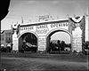 |
1901, 1909 | 1979-07-22 | Montrose Montrose, Colorado The City of Montrose is a Home Rule Municipality that is the county seat and the most populous city of Montrose County, Colorado, United States. The United States Census Bureau estimates that the city population was 15,479 in 2005. The main road that leads in and out of Montrose is U.S... |
Montrose Montrose County, Colorado Montrose County is the 17th most populous of the 64 counties of the State of Colorado of the United States. The county population was 41,276 at U.S. Census 2010. The county was named for its county seat, the City of Montrose... |
Irrigation tunnel |
| Hay's Ranch Bridge | 1900 | 1985-02-04 | Meeker Meeker, Colorado The Town of Meeker is a Statutory Town that is the county seat and the most populous town of Rio Blanco County, Colorado, United States. The town population was 2,242 at the U.S. Census 2000. The town is largely an agricultural community, located in the wide fertile valley of the White River in... 40°0′48"N 108°5′32"W |
Rio Blanco Rio Blanco County, Colorado Rio Blanco County is the sixth most extensive of the 64 counties of the State of Colorado of the United States. The county population was 5,986 at U.S. Census 2000. The name of the county is the Spanish language name for the White River which runs through it... |
Pratt Pony Truss | |
| Huerfano Bridge | 1921 | 1985-02-04 | Boone Boone, Colorado Boone is a Statutory Town in Pueblo County, Colorado, United States. It is part of the Pueblo, Colorado Metropolitan Statistical Area. The population was 333 at the 2000 census.... 38°13′32"N 104°15′39"W |
Pueblo Pueblo County, Colorado Pueblo County is the tenth most populous of the 64 counties of the state of Colorado of the United States. The county was named for the historic city of Pueblo which took its name from the Spanish language word meaning "town" or "village". The United States Census Bureau estimates that the... |
Filled Spandrel Arch | |
| Labo Del Rio Bridge | 1913 | 1985-06-24 | Arboles Arboles, Colorado Arboles is a census-designated place in Archuleta County, Colorado, United States. The population was 280 at the 2010 census. The Arboles Post Office has the ZIP Code 81121... 37°4′33"N 107°24′17"W |
Archuleta Archuleta County, Colorado Archuleta County is one of the 64 counties of the state of Colorado of the United States. The United States Census Bureau estimates that the county population was 12,386 in 2006, a 25.14% increase since U.S. Census 2000... |
Pratt through truss | |
| Lebanon and Everett Mine Tunnels | 1971-10-07 | Silver Plume Silver Plume, Colorado The historic Town of Silver Plume is a Statutory Town located in Clear Creek County, Colorado, United States. Silver Plume is a former silver mining camp along Clear Creek in the Front Range of the Rocky Mountains... 39°41′54"N 105°42′47"W |
Clear Creek Clear Creek County, Colorado Clear Creek County is one of the 64 counties of the state of Colorado of the United States. The county population was 9,322 at U.S. Census 2000. The county seat is Georgetown... |
|||
| Little Fountain Creek Bridge | 2002-10-15 | Widefield 38°40′36"N 104°50′55"W |
El Paso El Paso County, Colorado El Paso County is the most populous of the 64 counties of the state of Colorado of the United States, now more populous than Denver County. The United States Census Bureau concluded that the county population was 622,371 in 2010. In recent years, the population had come closer to that of Denver... |
Steel multiplate arch | ||
| Little Thompson River Bridge | 2002-10-15 | Berthoud Berthoud, Colorado Berthoud is a Statutory Town in Larimer and Weld counties in the U.S. state of Colorado. Berthoud is situated north of the Little Thompson River, approximately halfway between the cities of Fort Collins, Colorado and Denver, Colorado along the Front Range Urban Corridor... 40°18′3"N 104°58′44"W |
Weld Weld County, Colorado As of the census of 2000, there were 180,936 people, 63,247 households, and 45,221 families residing in the county. The population density was 45 people per square mile . There were 66,194 housing units at an average density of 17 per square mile... |
Camelback pony truss | ||
| Main Street Bridge | 2002-10-15 | Florence Florence, Colorado The City of Florence is a Statutory City located in Fremont County, Colorado, United States. The population was 3,653 at the 2000 census.ADX Florence, the only federal Supermax prison in the United States, is located south of Florence in an unincorporated area in Fremont County... 38°23′21"N 105°6′48"W |
Fremont Fremont County, Colorado Fremont County is the thirteenth most populous of the 64 counties of the state of Colorado of the United States. The county is named for explorer and presidential candidate John C. Frémont. The county population was 46,824 at the 2010 census. The county seat is Cañon City. The Cañon City... |
Spandrel arch | ||
| Maitland Arroyo Bridge | 2002-10-15 | Walsenburg Walsenburg, Colorado The City of Walsenburg or Los Leones is a Statutory City that is the county seat and the most populous city of Huerfano County, Colorado, United States... 37°39′57"N 104°50′0"W |
Huerfano Huerfano County, Colorado Huerfano County is one of the 64 counties of the State of Colorado of the United States. The county was named for the Huerfano Butte, a local landmark. The county population was 7,862 at U.S. Census 2000... |
Timber stringer | ||
| Manitou Springs Bridges | 1906, 1907 | 1985-06-24 | Manitou Springs Manitou Springs, Colorado The city of Manitou Springs is a Home Rule Municipality located in El Paso County, Colorado, United States. The population was 4,980 at the 2000 census.Students are served by Manitou Springs School District 14 and Manitou Springs High School.... 38°51′30"N 104°54′57"W |
El Paso El Paso County, Colorado El Paso County is the most populous of the 64 counties of the state of Colorado of the United States, now more populous than Denver County. The United States Census Bureau concluded that the county population was 622,371 in 2010. In recent years, the population had come closer to that of Denver... |
Stone arch | |
| Maroon Creek Bridge Maroon Creek Bridge The original Maroon Creek Bridge is a steel trestle along State Highway 82 at the western boundary of Aspen, Colorado, United States. It was designed by George S. Morison in 1888 for the Colorado Midland Railroad, one of the last trestles in Colorado built for a narrow gauge mountain railroad in... |
1888, 1929 | 1985-02-04 | Aspen Aspen, Colorado The City of Aspen is a Home Rule Municipality that is the county seat and the most populous city of Pitkin County, Colorado, United States. The United States Census Bureau estimates that the city population was 5,804 in 2005... 39°11′43"N 106°50′2"W |
Pitkin Pitkin County, Colorado Pitkin County is one of the 64 counties of the State of Colorado of the United States. The county is named in honor of the late Colorado Governor Frederick Walker Pitkin. The county population was 14,872 at U.S. Census 2000. The county seat is Aspen... |
Multi-span Trestle Bridge | |
| Miner Street Bridge | 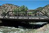 |
1901 | 1985-02-04 | Idaho Springs Idaho Springs, Colorado The City of Idaho Springs is a municipality in the U.S. state of Colorado that is the most populous settlement in Clear Creek County, Colorado. Idaho Springs is located in Clear Creek Canyon, in the mountains upstream from Golden, some thirty miles west of Denver... 39°39′40"N 105°30′45"W |
Clear Creek Clear Creek County, Colorado Clear Creek County is one of the 64 counties of the state of Colorado of the United States. The county population was 9,322 at U.S. Census 2000. The county seat is Georgetown... |
Skewed Pratt Pony Truss |
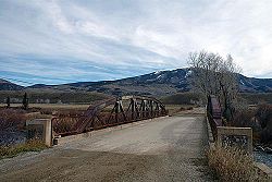
| Morley Bridge | 1881 | 2003-08-14 | Romley 38°40′30"N 106°21′51"W |
Chaffee Chaffee County, Colorado Chaffee County is one of the 64 counties of the state of Colorado of the United States. The county population was 16,242 at U.S. Census 2000. The county seat is Salida.-History:... |
Pratt deck truss | |
| North St. Vrain Creek Bridge | 2002-10-15 | Lyons Lyons, Colorado Lyons is a Statutory Town in Boulder County, Colorado, United States. The population was 1,585 at the 2000 census. Lyons is located at the confluence of the North St. Vrain Creek and the South St. Vrain Creek, twenty miles east of Rocky Mountain National Park. Due to its location at the... 40°13′22"N 105°16′17"W |
Boulder Boulder County, Colorado Boulder County is the sixth most populous of the 64 counties of the state of Colorado of the United States. The county seat is Boulder. The most populous municipality in the county and the county seat is the City of Boulder... |
Concrete rigid frame | ||
| Plum Bush Creek Bridge | 2002-10-15 | Last Chance Last Chance, Colorado Last Chance is an unincorporated community in Washington County, Colorado, United States. Last Chance is situated at the intersection of U.S. Highway 36 and State Highway 71 in a sparsely populated area of eastern Colorado. The town was supposedly so named because it was once the only place for... 39°44′23"N 103°32′43"W |
Washington Washington County, Colorado Washington County is the 12th most extensive of the 64 counties of the State of Colorado of the United States. The county population was 4,926 at U.S. Census 2000. The county was named in honor of the United States President George Washington... |
Concrete rigid frame | ||
| Portland Bridge | 1926 | 1985-02-04 | Portland Portland, Colorado Portland is a census-designated place in Ouray County, Colorado, United States. The population as of the 2010 Census was 135. Portland is located between Ridgway and Ouray.... 38°23′19"N 105°0′56"W |
Fremont Fremont County, Colorado Fremont County is the thirteenth most populous of the 64 counties of the state of Colorado of the United States. The county is named for explorer and presidential candidate John C. Frémont. The county population was 46,824 at the 2010 census. The county seat is Cañon City. The Cañon City... |
Pratt Semi-deck Truss | |
| Prowers Bridge | 1902, 1906, 1909 | 1985-02-04 | Prowers 38°5′37"N 102°46′3"W |
Bent Bent County, Colorado Bent County is one of the 64 counties of the state of Colorado of the United States. The county is named in honor of frontier trader William Bent. The county population was 5,998 at U.S. Census 2000... |
Camelback & Pratt Through | |
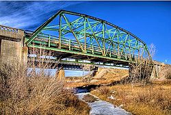
| Rainbow Arch Bridge | 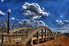 |
1922 | 1985-02-04 | Fort Morgan Fort Morgan, Colorado The City of Fort Morgan is a Home Rule Municipality that is the county seat and the most populous city of Morgan County, Colorado, United States. The United States Census Bureau estimated that the city population was 10,844 in 2005.-History:... 40°16′9"N 103°48′2"W |
Morgan Morgan County, Colorado Morgan County is the 18th most populous of the 64 counties of the State of Colorado of the United States. The county was named after old Fort Morgan, which in turn was named in honor of Colonel Christopher A. Morgan. The county population was 27,171 at U.S. Census 2000. The county seat is the... |
Fixed Rainbow (Marsh) Arch |
| Red Cliff Bridge Red Cliff Bridge Red Cliff Bridge is an arch bridge near Vail, Colorado that carries U.S. Highway 24 over the Eagle River and the former Union Pacific Railroad track over Tennessee Pass... |
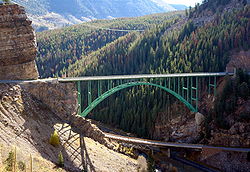 |
1940 | 1985-02-04 | Red Cliff Red Cliff, Colorado Red Cliff is a Statutory Town in Eagle County, Colorado, United States. The population was 289 at the 2000 census. The town is a former mining camp situated in the canyon of the upper Eagle River just off U.S. Highway 24 north of Tennessee Pass... 39°30′29"N 106°22′34"W |
Eagle Eagle County, Colorado Eagle County is the thirteenth most populous of the 64 counties of the State of Colorado in the United States. The county is named for the Eagle River. The county population was 41,659 at U.S. Census 2000. The county seat is the Town of Eagle... |
Deck Arch Bridge |
| Rifle Bridge | 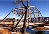 |
1909 | 1985-02-04 | Rifle Rifle, Colorado The City of Rifle is a Home Rule Municipality in Garfield County, Colorado, United States. The population was 6,769 at the 2000 census. Rifle is a regional center of the cattle ranching industry located along Interstate 70 and the Colorado River just east of the Roan Cliffs, which dominate the... 39°31′41"N 107°46′51"W |
Garfield Garfield County, Colorado Garfield County is the eighth most extensive and the twelfth most populous of the 64 counties of the State of Colorado of the United States. The county population was 43,791 at U.S. Census 2000. The county is named in honor of United States President James A. Garfield... |
Pennsylvania/Parker Truss |
| Rio Grande Railroad Viaduct | 2002-10-15 | Florence Florence, Colorado The City of Florence is a Statutory City located in Fremont County, Colorado, United States. The population was 3,653 at the 2000 census.ADX Florence, the only federal Supermax prison in the United States, is located south of Florence in an unincorporated area in Fremont County... 38°23′10"N 105°4′18"W |
Fremont Fremont County, Colorado Fremont County is the thirteenth most populous of the 64 counties of the state of Colorado of the United States. The county is named for explorer and presidential candidate John C. Frémont. The county population was 46,824 at the 2010 census. The county seat is Cañon City. The Cañon City... |
Cantilevered deck girder | ||
| Rito Seco Creek Culvert | 2002-10-15 | San Luis San Luis, Colorado The Town of San Luis is a statutory town that is the county seat and the most populous town of Costilla County, Colorado, United States. The population was 739 at the 2000 census.-History:... 37°12′0"N 105°25′34"W |
Costilla Costilla County, Colorado Costilla County is the ninth least populous of the 64 counties in the state of Colorado of the United States. The county population was 3,663 at U.S. Census 2000. The county seat is San Luis, the oldest town in Colorado.- History :... |
Multiplate arch | ||
| Rouch Gulch Bridge | 2002-11-27 | Swissvale 38°28′20"N 105°52′38"W |
Fremont Fremont County, Colorado Fremont County is the thirteenth most populous of the 64 counties of the state of Colorado of the United States. The county is named for explorer and presidential candidate John C. Frémont. The county population was 46,824 at the 2010 census. The county seat is Cañon City. The Cañon City... |
Concrete spandrel arch | ||
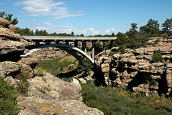
| Royal Gorge Bridge and Incline Railway | 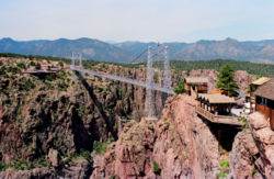 |
1929, 1931 | 1983-09-02 | Canon City Cañon City, Colorado The City of Cañon City is a Home Rule Municipality that is the county seat and the most populous city of Fremont County, State of Colorado. The United States Census Bureau estimated that the city population was 16,000 in 2005. Cañon City is noted for being the location of nine state and four ... |
Fremont Fremont County, Colorado Fremont County is the thirteenth most populous of the 64 counties of the state of Colorado of the United States. The county is named for explorer and presidential candidate John C. Frémont. The county population was 46,824 at the 2010 census. The county seat is Cañon City. The Cañon City... |
Suspension bridge |
| San Luis Bridge | 1911 | 1985-02-04 | San Luis San Luis, Colorado The Town of San Luis is a statutory town that is the county seat and the most populous town of Costilla County, Colorado, United States. The population was 739 at the 2000 census.-History:... 37°11′37"N 105°25′49"W |
Costilla Costilla County, Colorado Costilla County is the ninth least populous of the 64 counties in the state of Colorado of the United States. The county population was 3,663 at U.S. Census 2000. The county seat is San Luis, the oldest town in Colorado.- History :... |
Open Spandrel Arch | |
| San Luis Southern Railway Trestle aka Rattlesnake Trestle | 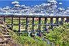 |
1910 | 2004-01-06 | Blanca Blanca, Colorado The Town of Blanca is a Statutory Town in Costilla County, Colorado, United States. The population was 391 at the 2000 census.-Geography:Blanca is located at .... 37°23′12"N 105°32′51"W |
Costilla Costilla County, Colorado Costilla County is the ninth least populous of the 64 counties in the state of Colorado of the United States. The county population was 3,663 at U.S. Census 2000. The county seat is San Luis, the oldest town in Colorado.- History :... |
Railroad Trestle |
| Santa Fe Avenue Bridge | 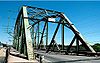 |
2002-10-15 | Pueblo Pueblo, Colorado Pueblo is a Home Rule Municipality that is the county seat and the most populous city of Pueblo County, Colorado, United States. The population was 106,595 in 2010 census, making it the 246th most populous city in the United States.... 38°15′15"N 104°36′23"W |
Pueblo Pueblo County, Colorado Pueblo County is the tenth most populous of the 64 counties of the state of Colorado of the United States. The county was named for the historic city of Pueblo which took its name from the Spanish language word meaning "town" or "village". The United States Census Bureau estimates that the... |
Pennsylvania through truss | |
| Satank Bridge | 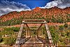 |
1900 | 1985-02-04 | Carbondale Carbondale, Colorado Carbondale is a Home Rule Municipality in Garfield County, Colorado, United States. The population was 5,196 at the 2000 census. The town is located in the mid valley of the Roaring Fork River, downstream from Aspen and upstream from the mouth of the Roaring Fork at Glenwood Springs. The town... 39°25′2"N 107°13′48"W |
Garfield Garfield County, Colorado Garfield County is the eighth most extensive and the twelfth most populous of the 64 counties of the State of Colorado of the United States. The county population was 43,791 at U.S. Census 2000. The county is named in honor of United States President James A. Garfield... |
Pratt Through Truss |
| Sevenmile Bridge | 1935, 1981 | 1985-07-11 | Creede Creede, Colorado The historic town of Creede is a Statutory Town that is the county seat of, and the only incorporated municipality in, Mineral County, Colorado, United States. The town population was 377 at the U.S. Census 2000.-History:... 37°47′33"N 106°58′51"W |
Mineral Mineral County, Colorado Mineral County is the second least populous of the 64 counties of the State of Colorado of the United States. The county was named for the many valuable minerals found in the mountains and streams of the area. The county population was 831 at U.S. Census 2000... |
Pratt deck truss | |
| Sheely Bridge Sheely Bridge The Sheely Bridge carries pedestrian traffic across the Roaring Fork River in Mill Street Park in Aspen, Colorado, United States. It is a short steel truss bridge originally located downstream in Carbondale and later moved to its present location.... |
1911, 1966 | 1985-02-04 | Aspen Aspen, Colorado The City of Aspen is a Home Rule Municipality that is the county seat and the most populous city of Pitkin County, Colorado, United States. The United States Census Bureau estimates that the city population was 5,804 in 2005... 39°11′27"N 106°48′46"W |
Pitkin Pitkin County, Colorado Pitkin County is one of the 64 counties of the State of Colorado of the United States. The county is named in honor of the late Colorado Governor Frederick Walker Pitkin. The county population was 14,872 at U.S. Census 2000. The county seat is Aspen... |
Pratt Through Truss | |
| Slate Creek Bridge Slate Creek Bridge The Slate Creek Bridge is a riveted steel Parker pony truss bridge spanning the Blue River north of Silverthorne, Colorado. It is named after the road it carries, Slate Creek Road. This rare example of an uncommon truss type was listed on the National Register of Historic Places in 1985.... |
 |
1924 | 1985-06-24 | Slate Creek 39°47′0"N 106°9′43"W |
Summit Summit County, Colorado Summit County is the 19th most populous of the 64 counties of the state of Colorado of the United States. The county population was 23,538 at U.S. Census 2000. The county seat is Breckenridge... |
Parker Pony truss |
| South Canon Bridge South Canon Bridge The South Canon Bridge is a truss footbridge spanning the Colorado River near Glenwood Springs, Colorado. It was built in 1915 by the Missouri Valley Bridge & Iron Co., but is now closed to vehicular traffic.... |
 |
1914 | 1985-02-04 | Glenwood Springs Glenwood Springs, Colorado The City of Glenwood Springs is a Home Rule Municipality that is the county seat and the most populous city of Garfield County, Colorado, United States. The United States Census Bureau estimated that the city population was 8,564 in 2005... 39°33′42"N 107°24′23"W |
Garfield Garfield County, Colorado Garfield County is the eighth most extensive and the twelfth most populous of the 64 counties of the State of Colorado of the United States. The county population was 43,791 at U.S. Census 2000. The county is named in honor of United States President James A. Garfield... |
Pennsylvania Through Truss |
| South Platte River Bridges South Platte River Bridges South Platte River Bridges are a pair of historic arch bridges over the South Platte River on the Valley Highway in Denver, Colorado.-External links:*... |
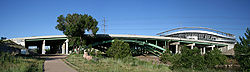 |
1951 | 2002-10-15 | Denver Denver, Colorado The City and County of Denver is the capital and the most populous city of the U.S. state of Colorado. Denver is a consolidated city-county, located in the South Platte River Valley on the western edge of the High Plains just east of the Front Range of the Rocky Mountains... 39°44′36"N 105°0′56"W |
Denver | Girder-ribbed deck arch |
| Spring Creek Bridge |  |
2002-10-15 | Vona Vona, Colorado Vona is a Statutory Town in Kit Carson County, Colorado, United States. The population was 95 at the 2000 census.-Geography:Vona is located at .According to the United States Census Bureau, the town has a total area of , all of it land.-Demographics:... 39°18′1"N 102°43′41"W |
Kit Carson Kit Carson County, Colorado Kit Carson County is the 18th most extensive of the 64 counties of the State of Colorado of the United States. The county population was 8,011 at U.S. Census 2000. The county was named for Kit Carson... |
Concrete Slab | |
| St. Charles Bridge | 1924 | 1985-02-04 | Pueblo Pueblo, Colorado Pueblo is a Home Rule Municipality that is the county seat and the most populous city of Pueblo County, Colorado, United States. The population was 106,595 in 2010 census, making it the 246th most populous city in the United States.... 38°12′3"N 104°32′46"W |
Pueblo Pueblo County, Colorado Pueblo County is the tenth most populous of the 64 counties of the state of Colorado of the United States. The county was named for the historic city of Pueblo which took its name from the Spanish language word meaning "town" or "village". The United States Census Bureau estimates that the... |
Filled Spandrel Arch | |
| State Bridge | 1890 | 1985-06-24 | State Bridge 39°51′29"N 106°38′54"W |
Eagle Eagle County, Colorado Eagle County is the thirteenth most populous of the 64 counties of the State of Colorado in the United States. The county is named for the Eagle River. The county population was 41,659 at U.S. Census 2000. The county seat is the Town of Eagle... |
Howe truss | |
| Sutherland Bridge |  |
1924 | 1985-02-04 | Del Norte Del Norte, Colorado The Town of Del Norte is a Statutory Town in and the county seat of Rio Grande County, Colorado, United States. The town population was 1,705 at the 2000 census.-Geography:Del Norte is located at .... 37°40′35"N 106°19′36"W |
Rio Grande Rio Grande County, Colorado Rio Grande County is one of the 64 counties of the State of Colorado of the United States. The county is named for the Rio Grande , which flows through the county. The county population was 12,413 at U.S. Census 2000... |
Warren Pony Truss |
| West Plum Bush Creek Bridge | 2002-10-15 | Last Chance Last Chance, Colorado Last Chance is an unincorporated community in Washington County, Colorado, United States. Last Chance is situated at the intersection of U.S. Highway 36 and State Highway 71 in a sparsely populated area of eastern Colorado. The town was supposedly so named because it was once the only place for... 39°44′23"N 103°36′40"W |
Washington Washington County, Colorado Washington County is the 12th most extensive of the 64 counties of the State of Colorado of the United States. The county population was 4,926 at U.S. Census 2000. The county was named in honor of the United States President George Washington... |
Concrete rigid frame | ||
| Wheeler Bridge | 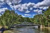 |
1924 | 1985-02-04 | Del Norte Del Norte, Colorado The Town of Del Norte is a Statutory Town in and the county seat of Rio Grande County, Colorado, United States. The town population was 1,705 at the 2000 census.-Geography:Del Norte is located at .... 37°39′29"N 106°17′20"W |
Rio Grande Rio Grande County, Colorado Rio Grande County is one of the 64 counties of the State of Colorado of the United States. The county is named for the Rio Grande , which flows through the county. The county population was 12,413 at U.S. Census 2000... |
Howe Pony Truss |
| Wolcott Bridge | 2002-10-15 | Wolcott Wolcott, Colorado Wolcott is a census-designated place and a U.S. Post Office located in Eagle County, Colorado, United States. The population as of the 2010 Census was 15.The Wolcott Post Office has the ZIP Code 81655.... 39°42′6"N 106°40′39"W |
Eagle Eagle County, Colorado Eagle County is the thirteenth most populous of the 64 counties of the State of Colorado in the United States. The county is named for the Eagle River. The county population was 41,659 at U.S. Census 2000. The county seat is the Town of Eagle... |
Luten arch | ||
| 14th Street Viaduct | 1898 | removed 1994-07-22 |
Denver Denver, Colorado The City and County of Denver is the capital and the most populous city of the U.S. state of Colorado. Denver is a consolidated city-county, located in the South Platte River Valley on the western edge of the High Plains just east of the Front Range of the Rocky Mountains... |
Denver | steel stringer viaduct | |
| 20th Street Viaduct | 1909 | removed 1994-07-22 |
Denver Denver, Colorado The City and County of Denver is the capital and the most populous city of the U.S. state of Colorado. Denver is a consolidated city-county, located in the South Platte River Valley on the western edge of the High Plains just east of the Front Range of the Rocky Mountains... |
Denver | Deck Girder/Through Truss | |
| Avery Bridges | 1914 | removed 2002-09-16 |
Hoehne and Aguilar | Las Animas Las Animas County, Colorado Las Animas County has the largest area of the 64 counties of the State of Colorado of the United States. Las Animas County takes its name from the Mexican Spanish name of the Purgatoire River, originally called El Río de las Ánimas Perdidas en Purgatorio, which means "River of the Lost Souls in... |
Avery pony truss | |
| Big Thompson River Bridge I | 2002-10-15 removed 2010-11-29 |
Estes Park Estes Park, Colorado Estes Park is a town in Larimer County, Colorado, United States. A popular summer resort and the location of the headquarters for Rocky Mountain National Park, Estes Park lies along the Big Thompson River. Estes Park had a population of 5,858 at the 2010 census... 40°22′49"N 105°28′19"W |
Larimer Larimer County, Colorado Larimer County is the seventh most populous and the ninth most extensive of the 64 counties of the State of Colorado of the United States. The county is located at the northern end of the Front Range, at the edge of the Colorado Eastern Plains along the border with Wyoming... |
Camelback pony truss | ||
| Big Thompson River Bridge II | 2002-10-15 removed 2010-11-29 |
Estes Park Estes Park, Colorado Estes Park is a town in Larimer County, Colorado, United States. A popular summer resort and the location of the headquarters for Rocky Mountain National Park, Estes Park lies along the Big Thompson River. Estes Park had a population of 5,858 at the 2010 census... 40°23′22"N 105°27′49"W |
Larimer Larimer County, Colorado Larimer County is the seventh most populous and the ninth most extensive of the 64 counties of the State of Colorado of the United States. The county is located at the northern end of the Front Range, at the edge of the Colorado Eastern Plains along the border with Wyoming... |
Camelback pony truss | ||
| Black Bridge | 1891 | removed 1994-07-22 |
Grand Junction Grand Junction, Colorado The City of Grand Junction is the largest city in western Colorado. It is a city with a council–manager government form that is the county seat and the most populous city of Mesa County, Colorado, United States. Grand Junction is situated west-southwest of the Colorado State Capitol in Denver. As... |
Mesa Mesa County, Colorado Mesa County is the fourth most extensive and the eleventh most populous of the 64 counties of the state of Colorado in the United States. The county was named for the many large mesas in the area, including Grand Mesa. The county population was 146,723 at the 2010 United States Census. The... |
Pratt Through Truss | |
| Broadway Bridge | 1895 | removed 1995-02-27 |
Denver Denver, Colorado The City and County of Denver is the capital and the most populous city of the U.S. state of Colorado. Denver is a consolidated city-county, located in the South Platte River Valley on the western edge of the High Plains just east of the Front Range of the Rocky Mountains... |
Denver | Open-Web Deck Girder | |
| Commercial Street Bridge | 1905 | removed 1994-07-22 |
Trinidad Trinidad, Colorado The historic City of Trinidad is a Home Rule Municipality that is the county seat and the most populous city of Las Animas County, Colorado, United States... |
Las Animas Las Animas County, Colorado Las Animas County has the largest area of the 64 counties of the State of Colorado of the United States. Las Animas County takes its name from the Mexican Spanish name of the Purgatoire River, originally called El Río de las Ánimas Perdidas en Purgatorio, which means "River of the Lost Souls in... |
Luten Arch | |
| Delta Bridge | 1923 | removed 1994-07-22 |
Delta Delta, Colorado The City of Delta is the county seat and the most populous city of Delta County, Colorado, United States. The population was 8,915 at the 2010 census... |
Delta Delta County, Colorado Delta County is the 17th most populous of the 64 counties of the State of Colorado of the United States. The county population was 27,834 in the 2000 U.S. Census. The county seat is the City of Delta... |
4-span Parker Through Truss | |
| Elson Bridge | 1905 | removed 2002-09-16 |
El Moro | Las Animas Las Animas County, Colorado Las Animas County has the largest area of the 64 counties of the State of Colorado of the United States. Las Animas County takes its name from the Mexican Spanish name of the Purgatoire River, originally called El Río de las Ánimas Perdidas en Purgatorio, which means "River of the Lost Souls in... |
Pratt Through Truss | |
| Escalante Canon Bridge | 1890, 1908, 1938 | removed 1994-07-22 |
Delta Delta, Colorado The City of Delta is the county seat and the most populous city of Delta County, Colorado, United States. The population was 8,915 at the 2010 census... |
Delta Delta County, Colorado Delta County is the 17th most populous of the 64 counties of the State of Colorado of the United States. The county population was 27,834 in the 2000 U.S. Census. The county seat is the City of Delta... |
Camelback Through Truss | |
| Fourth Street Bridge | 1891 | 1985-02-04 removed 2010-1-14 |
Canon City Cañon City, Colorado The City of Cañon City is a Home Rule Municipality that is the county seat and the most populous city of Fremont County, State of Colorado. The United States Census Bureau estimated that the city population was 16,000 in 2005. Cañon City is noted for being the location of nine state and four ... 38°26′22"N 105°13′52"W |
Fremont Fremont County, Colorado Fremont County is the thirteenth most populous of the 64 counties of the state of Colorado of the United States. The county is named for explorer and presidential candidate John C. Frémont. The county population was 46,824 at the 2010 census. The county seat is Cañon City. The Cañon City... |
Pratt Through Truss | |
| Fifth Street Bridge | 1933 | removed 1994-07-22 |
Grand Junction Grand Junction, Colorado The City of Grand Junction is the largest city in western Colorado. It is a city with a council–manager government form that is the county seat and the most populous city of Mesa County, Colorado, United States. Grand Junction is situated west-southwest of the Colorado State Capitol in Denver. As... |
Mesa Mesa County, Colorado Mesa County is the fourth most extensive and the eleventh most populous of the 64 counties of the state of Colorado in the United States. The county was named for the many large mesas in the area, including Grand Mesa. The county population was 146,723 at the 2010 United States Census. The... |
Parker Through Truss | |
| Four Mile Bridge | 1900 | removed 1994-07-22 |
Steamboat Springs Steamboat Springs, Colorado The city of Steamboat Springs is a Home Rule Municipality that is the county seat and the most populous city of Routt County, Colorado, United States. The city is also known as "Steamboat," "The Boat," or "Ski Town USA". As of the 2010 census, the city population was 12,088.The city is an... |
Routt Routt County, Colorado Routt County is the 15th most extensive of the 64 counties of the state of Colorado of the United States. The county population was 19,690 at U.S. Census 2000. The county seat is Steamboat Springs.- History :... |
Pratt Through Truss | |
| Hortense Bridge | 1880 | removed 1997-04-14 |
Nathrop Nathrop, Colorado Nathrop is a ghost town and a U.S. Post Office located in Chaffee County, Colorado, United States. The Nathrop Post Office has the ZIP Code 81236.... |
Chaffee Chaffee County, Colorado Chaffee County is one of the 64 counties of the state of Colorado of the United States. The county population was 16,242 at U.S. Census 2000. The county seat is Salida.-History:... |
Queenpost Pony Truss | |
| Hotchkiss Bridge | 1911 | removed 1994-07-22 |
Hotchkiss Hotchkiss, Colorado Hotchkiss is a Statutory Town in Delta County, Colorado, United States. The population was 968 at the 2000 census.-Geography:Hotchkiss is located at .... |
Delta Delta County, Colorado Delta County is the 17th most populous of the 64 counties of the State of Colorado of the United States. The county population was 27,834 in the 2000 U.S. Census. The county seat is the City of Delta... |
Camelback Through Truss | |
| Howard Bridge | 1924 | removed 2002-09-16 |
Howard Howard, Colorado Howard is a census-designated place and a U.S. Post Office in Fremont County, Colorado, United States. The population as of the 2010 Census was 723.The Howard Post Office has the ZIP Code 81233.... |
Fremont Fremont County, Colorado Fremont County is the thirteenth most populous of the 64 counties of the state of Colorado of the United States. The county is named for explorer and presidential candidate John C. Frémont. The county population was 46,824 at the 2010 census. The county seat is Cañon City. The Cañon City... |
Warren Pony Truss Bridge | |
| Manzanola Bridge | 1911, 1950 | removed 1994-07-22 |
Manzanola Manzanola, Colorado Manzanola is a Statutory Town in Otero County, Colorado, United States. The population was 525 at the 2000 census.-Geography:Manzanola is located at .... |
Crowley Crowley County, Colorado Crowley County is one of the 64 counties of the State of Colorado of the United States. The county population was 5,518 at U.S. Census 2000. The county seat is Ordway.- History :... |
Pennsylvania through truss | |
| Masonic Park Bridge | 1909, 1933 | removed 1994-07-22 |
South Fork South Fork, Colorado South Fork is a Statutory Town in Rio Grande County, Colorado, United States. The population was 604 at the 2000 census.-Geography:South Fork is located at .According to the United States Census Bureau, the town has a total area of , all of it land.... |
Rio Grande Rio Grande County, Colorado Rio Grande County is one of the 64 counties of the State of Colorado of the United States. The county is named for the Rio Grande , which flows through the county. The county population was 12,413 at U.S. Census 2000... |
Pratt Through Truss | |
| Nepesta Bridge | 1905 | removed 1994-07-22 |
Boone Boone, Colorado Boone is a Statutory Town in Pueblo County, Colorado, United States. It is part of the Pueblo, Colorado Metropolitan Statistical Area. The population was 333 at the 2000 census.... |
Pueblo Pueblo County, Colorado Pueblo County is the tenth most populous of the 64 counties of the state of Colorado of the United States. The county was named for the historic city of Pueblo which took its name from the Spanish language word meaning "town" or "village". The United States Census Bureau estimates that the... |
Pratt Through Truss | |
| Roubideau Bridge | 1911 | removed 1994-07-22 |
Delta Delta, Colorado The City of Delta is the county seat and the most populous city of Delta County, Colorado, United States. The population was 8,915 at the 2010 census... |
Delta Delta County, Colorado Delta County is the 17th most populous of the 64 counties of the State of Colorado of the United States. The county population was 27,834 in the 2000 U.S. Census. The county seat is the City of Delta... |
Warren Through Truss | |
| Whiskey Creek Trestle | 1905 | removed 1987-11-25 |
Rangely Rangely, Colorado Rangely is a Statutory Town in Rio Blanco County, Colorado, United States. The population was 2,096 at the 2000 census. The town is home to one of two campuses of the Colorado Northwestern Community College.-Geography:... |
Rio Blanco Rio Blanco County, Colorado Rio Blanco County is the sixth most extensive of the 64 counties of the State of Colorado of the United States. The county population was 5,986 at U.S. Census 2000. The name of the county is the Spanish language name for the White River which runs through it... |