

List of World Heritage Sites in Western Asia
Encyclopedia
This is a list of the UNESCO World Heritage Site
s in Western Asia.
World Heritage Site
A UNESCO World Heritage Site is a place that is listed by the UNESCO as of special cultural or physical significance...
s in Western Asia.
Legend
The table is sortable by column by clicking on the at the top of the appropriate column; alphanumerically for the Site, Area, and Year columns; by state party for the Location column; and by criteria type for the Criteria column. Transborder sites sort at the bottom.- Site; named after the World Heritage Committee's official designation
- Location; at city, regional, or provincial level and geocoordinates
- Criteria; as defined by the World Heritage Committee
- Area; in hectareHectareThe hectare is a metric unit of area defined as 10,000 square metres , and primarily used in the measurement of land. In 1795, when the metric system was introduced, the are was defined as being 100 square metres and the hectare was thus 100 ares or 1/100 km2...
s and acreAcreThe acre is a unit of area in a number of different systems, including the imperial and U.S. customary systems. The most commonly used acres today are the international acre and, in the United States, the survey acre. The most common use of the acre is to measure tracts of land.The acre is related...
s. If available, the size of the buffer zone has been noted as well. A value of zero implies that no data has been published by UNESCO - Year; during which the site was inscribed to the World Heritage List
- Description; brief information about the site, including reasons for qualifying as an endangered site, if applicable
Inscribed sites
| Site | Image | Location | Criteria | Area ha (acre) |
Year | Description | Refs |
|---|---|---|---|---|---|---|---|
| Qal’at al-Bahrain – Ancient Harbour and Capital of Dilmun | Cultural: (ii)(iii)(iv) |
32 (79.1 acre); buffer zone 1238 (3,059.2 acre) | 2005Minor modification of the core zone and enlargement of the bufer zone in 2008. | The site was the capital of the Dilmun, one of the most important ancient civilizations of the region. It contains the richest remains inventoried of this civilization, which was hitherto only known from written Sumerian references. | |||
| Ashur (Qal'at Sherqat) | Cultural: (iii)(iv) |
70 (173 acre); buffer zone 100 (247.1 acre) | 2003 | The ancient city of Ashur is located on the Tigris River in northern Mesopotamia. The city dates back to the 3rd millennium BC. From the 14th to the 9th centuries BC it was the first capital of the Assyrian Empire. The city was destroyed by the Babylonians, but revived during the Parthian period in the 1st and 2nd centuries AD. The site has been listed as endangered since inscription because of a lack of adequate protection and a planned reservoir tat would partially flood the site. | |||
| Hatra Hatra Hatra is an ancient city in the Ninawa Governorate and al-Jazira region of Iraq. It is currently known as al-Hadr, a name which appears once in ancient inscriptions, and it was in the ancient Iranian province of Khvarvaran. The city lies northwest of Baghdad and southwest of Mosul.-History:Hatra... |
 |
Cultural: (ii)(iii)(iv)(vi) |
324 (800.6 acre) | 1985 | A large fortified city under the influence of the Parthian Empire and capital of the first Arab Kingdom, Hatra withstood invasions by the Romans in A.D. 116 and 198 thanks to its high, thick walls reinforced by towers. | ||
| Samarra Archaeological City | Cultural: (ii)(iii)(iv) |
15058 (37,209.1 acre); buffer zone 31414 (77,625.6 acre) | 2007 | Samarra Archaeological City is the site of a powerful Islamic capital city that ruled over the provinces of the Abbasid Empire extending from Tunisia to Central Asia for a century. The 9th-century Great Mosque and its spiral minaret are among the numerous remarkable architectural monuments of the site, 80% of which remain to be excavated. The site has been listed as endangered since inscription due to the lack of state control for protection and management following the Iraq War. | |||
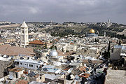 |
The Old City of Jerusalem and its Walls | Jerusalem | Cultural: (ii)(iii)(vi) |
— | 1985 | As a holy city for Judaism, Christianity and Islam, Jerusalem has always been of great symbolic importance. It is recognized by all three religions as the site of Abraham's sacrifice. The Wailing Wall delimits the quarters of the different religious communities, while the Resurrection rotunda in the Church of the Holy Sepulchre houses Christ's tomb. | |
| Petra Petra Petra is a historical and archaeological city in the Jordanian governorate of Ma'an that is famous for its rock cut architecture and water conduits system. Established sometime around the 6th century BC as the capital city of the Nabataeans, it is a symbol of Jordan as well as its most visited... |
Ma'an Governorate Ma'an Governorate Ma'an is one of the governorates of Jordan, it is located south of Amman, Jordan's capital. Its capital is the city of Ma'an. This governorate is the largest in the kingdom of Jordan by area.-History:... ,  Jordan Jordan |
Cultural: (i)(iii)(iv) |
— | 1985 | Inhabited since prehistoric times, this Nabataean caravan-city, situated between the Red Sea and the Dead Sea, was an important crossroads between Arabia, Egypt and Syria-Phoenicia. Petra is half-built, half-carved into the rock, and is surrounded by mountains riddled with passages and gorges. | ||
| Qasr Amra Qasr Amra Qasr Amra , often Quseir Amra or Qusayr Amra, is the best-known of the desert castles located in present-day eastern Jordan. It was built early in the 8th century by the Umayyad caliph Walid I whose dominance of the region was rising at the time... |
Zarqa Governorate Zarqa Governorate Zarqa Governorate is the third largest governorate in Jordan by population. The capital of Zarqa governorate is Zarqa City, which is the largest city in the governorate. It is located 25 km east of the Jordanian capital Amman... , Jordan |
Cultural: (i)(iii)(iv) |
— | 1985 | Built in the early 8th century, this exceptionally well-preserved desert castle was both a fortress with a garrison and a residence of the Umayyad caliphs. | ||
| Um er-Rasas (Kastrom Mefa'a) | Madaba Governorate Madaba Governorate Madaba, is one of the governorates of Jordan, it is located south west of Amman, capital of Jordan. Its capital is Madaba. The governorate is ranked eighth by population and by area in Jordan... , Jordan |
Cultural: (i)(iv)(vi) |
24 (59.3 acre) | 2005 | Most of this archaeological site, which started as a Roman military camp and grew to become a town from the 5th century, has not been excavated. It contains remains from the Roman, Byzantine and Early Muslim periods (end of 3rd to 9th centuries AD) and a fortified Roman military camp. | ||
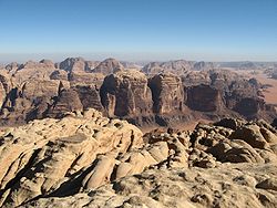 |
Wadi Rum Wadi Rum Wadi Rum also known as The Valley of the Moon is a valley cut into the sandstone and granite rock in south Jordan at to the east of Aqaba. It is the largest wadi in Jordan. The name Rum most likely comes from an Aramaic root meaning 'high' or 'elevated'. To reflect its proper Arabic... Protected Area |
Aqaba Governorate Aqaba Governorate Aqaba is one of the governorates of Jordan, located south of Amman, capital of Jordan. Its capital is Aqaba. It is the fourth largest governorate in Jordan by area and is ranked 10th by population.... , Jordan |
Mixed: (iii)(v)(vii) |
74180 (183,302.6 acre) | 2005 | The 74,000-hectare property, inscribed as a mixed natural and cultural site, is situated in southern Jordan, near the border with Saudi Arabia. It features a varied desert landscape, as well as 25,000 rock carvings with 20,000 inscriptions trace the evolution of human thought and the early development of the alphabet. | |
| Anjar Anjar, Lebanon Anjar , also known as Haoush Mousa , is a town of Lebanon located in the Bekaa Valley. The population is 2,400, consisting almost entirely of Armenians. The total area is about twenty square kilometers... |
Beqaa Governorate Beqaa Governorate Beqaa is a governorate in Lebanon with a population of 750,000 inhabitants.-Geography:The Beqaa governorate covers an area of 4,429 km². Béqaa is the primary center of Lebanon's agriculture. The Beqaa governorate forms the main geographical extension of Lebanon and it lies between the Western... ,  Lebanon Lebanon |
Cultural: (iii)(iv) |
— | 1984 | The city of Anjar was founded by Caliph Walid I at the beginning of the 8th century. The ruins reveal a very regular layout, reminiscent of the palace-cities of ancient times, and are a unique testimony to city planning under the Umayyads. | ||
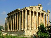 |
Baalbek Baalbek Baalbek is a town in the Beqaa Valley of Lebanon, altitude , situated east of the Litani River. It is famous for its exquisitely detailed yet monumentally scaled temple ruins of the Roman period, when Baalbek, then known as Heliopolis, was one of the largest sanctuaries in the Empire... |
Beqaa Governorate Beqaa Governorate Beqaa is a governorate in Lebanon with a population of 750,000 inhabitants.-Geography:The Beqaa governorate covers an area of 4,429 km². Béqaa is the primary center of Lebanon's agriculture. The Beqaa governorate forms the main geographical extension of Lebanon and it lies between the Western... , Lebanon |
Cultural: (i)(iv) |
— | 1984 | Baalbek, where a triad of deities was worshipped, was known as Heliopolis during the Hellenistic period. It retained its religious function during Roman times, when the sanctuary of the Heliopolitan Jupiter attracted thousands of pilgrims. | |
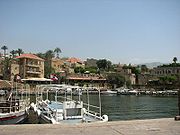 |
Byblos Byblos Byblos is the Greek name of the Phoenician city Gebal . It is a Mediterranean city in the Mount Lebanon Governorate of present-day Lebanon under the current Arabic name of Jubayl and was also referred to as Gibelet during the Crusades... |
Mount Lebanon Governorate Mount Lebanon Governorate Mount Lebanon is one of the Governorates of Lebanon. Its capital is Baabda. The overwhelming majority of its population is Maronites, Greek Orthodox, and Melkite Greek Catholic Christians... , Lebanon |
Cultural: (iii)(iv)(vi) |
— | 1984 | The ruins of many successive civilizations are found at Byblos, one of the oldest Phoenician cities. Inhabited since Neolithic times, it has been closely linked to the legends and history of the Mediterranean region for thousands of years. | |
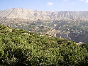 |
Ouadi Qadisha Kadisha Valley The Kadisha Valley is a valley that lies within the Becharre and Zgharta Districts of the North Governorate of Lebanon. The valley is a deep gorge carved by the Kadisha River, also known as the Nahr Abu Ali when it reaches Tripoli... (the Holy Valley) and the Forest of the Cedars of God Cedars of God The Cedars of God is one of the the last vestiges of the extensive forests of the Cedars of Lebanon that thrived across Mount Lebanon in ancient times. Their timber was exploited by the Assyrians, Babylonians and Persians as well as the Phoenicians... (Horsh Arz el-Rab) |
North Lebanon Governorate, Lebanon |
Cultural: (iii)(iv) |
— | 1998 | The Qadisha valley is one of the most important early Christian monastic settlements in the world. Nearby are the remains of the great forest of cedars of Lebanon, highly prized in antiquity for the construction of great religious buildings. | |
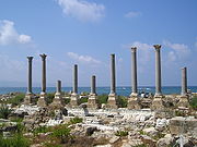 |
Tyre | South Lebanon Governorate, Lebanon |
Cultural: (iii)(vi) |
154 (380.5 acre) | 1984 | Tyre ruled the seas and founded prosperous colonies such as Cadiz and Carthage, but its historical role declined at the end of the Crusades. There are important archaeological remains, mainly from Roman times. | |
| — | Aflaj Irrigation Systems of Oman | Sharqiyah and Batinah Al Batinah Region Al Bāţinah is one of the regions of Oman.Al Batinah Region, otherwise known as Al Batinah, occupies an important location on the coast of Gulf of Oman. It lies between Khatmat Malahah in the north and Ras AL Hamra in the south and confined between the Al Hajar Mountains in the west and the Gulf... Regions,  Oman Oman |
Cultural: (v) |
1456 (3,597.9 acre) | 2006 | The property includes five aflaj irrigation systems and is representative of some 3,000 such systems still in use in Oman. The origins of this system of irrigation may date back to AD 500, but archaeological evidence suggests that irrigation systems existed in this extremely arid area as early as 2500 BC. | |
| — | Archaeological Sites of Bat, Al-Khutm and Al-Ayn | Ad Dhahirah Region, Oman |
Cultural: (iii)(iv) |
— | 1988 | The protohistoric site of Bat lies near a palm grove in the interior of the Sultanate of Oman. Together with the neighbouring sites, it forms the most complete collection of settlements and necropolises from the 3rd millennium B.C. in the world. | |
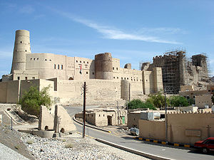 |
Bahla Fort Bahla Fort Bahla Fort is one of four historic fortresses situated at the foot of the Djebel Akhdar highlands in Oman. It was built in the 13th and 14th centuries, when the oasis of Bahla was prosperous under the control of the Banu Nebhan tribe. The fort's ruined adobe walls and towers rise some... |
Ad Dakhiliyah Region Ad Dakhiliyah Region Ad Dakhiliyah is one of the regions of Oman with Nizwa town as the regional center.Ad Dakhiliyah Region consists of eight wilayats: Nizwa, Samail, Bahla, Adam, Al Hamra, Manah, Izki and Bid Bid.... , Oman |
Cultural: (iv) |
— | 1987 | The oasis of Bahla owes its prosperity to the Banu Nebhan, the dominant tribe in the area from the 12th to the end of the 15th century. The ruins of the immense fort, with its walls and towers of unbaked brick and its stone foundations, is a remarkable example of this type of fortification and attests to the power of the Banu Nebhan. | |
| — | Land of Frankincense Frankincense trail The Frankincense Trail is a site in Oman on the Incense Road. The site includes frankincense trees and the remains of a caravan oasis, which were crucial to the medieval incense trade.The Frankincense Trail has been declared a UNESCO World Heritage Site.... |
Dhofar Governorate, Oman |
Cultural: (iii)(iv) |
850 (2,100.4 acre) | 2000 | The frankincense trees of Wadi Dawkah and the remains of the caravan oasis of Shisr/Wubar and the affiliated ports of Khor Rori and Al-Baleed vividly illustrate the trade in frankincense that flourished in this region for many centuries, as one of the most important trading activities of the ancient and medieval world. | |
 |
Al-Hijr Archaeological Site (Madâin Sâlih) | Al Madinah Province, Saudi Arabia Saudi Arabia |
Cultural: (ii)(iii) |
1621 (4,005.6 acre) | 2008 | Formerly known as Hegra it is the largest conserved site of the civilization of the Nabataeans south of Petra in Jordan. It features well-preserved monumental tombs with decorated facades dating from the 1st century BC to the 1st century AD. | |
| At-Turaif District in ad-Dir'iyah Diriyah Al-Diriyah is a town in Saudi Arabia located on the northwestern outskirts of the Saudi capital, Riyadh. Diriyah was the original home of the Saudi royal family, and served as the capital of the first Saudi dynasty from 1744 to 1818... |
Riyadh Province, Saudi Arabia |
Cultural: (ii)(iii) |
29 (71.7 acre) | 2008 | Diriyah was the first capital of the Saudi Dynasty, in the heart of the Arabian Penisula, north-west of Riyadh. It includes the remains of many palaces and an urban ensemble built on the edge of the ad-Dir’iyah oasis. | ||
| Ancient City of Aleppo | Aleppo Governorate Aleppo Governorate Aleppo Governorate is one of the fourteen governorates of Syria. It is the most populous governorate in Syria with a population of more than 4,744,000 , almost 23% of the total population of Syria. The governorate is the fifth in area with an area of 18,482 km², about 10% of the total area of... ,  Syria Syria |
Cultural: (iii)(iv) |
— | 1986 | Located at the crossroads of several trade routes from the 2nd millennium B.C., Aleppo was ruled successively by the Hittites, Assyrians, Arabs, Mongols, Mamelukes and Ottomans. | ||
| Ancient City of Bosra | Daraa Governorate, Syria |
Cultural: (i)(iii)(vi) |
— | 1980 | Bosra, once the capital of the Roman province of Arabia, was an important stopover on the ancient caravan route to Mecca. A magnificent 2nd-century Roman theatre, early Christian ruins and several mosques are found within its great walls. | ||
| Ancient City of Damascus | Damascus Governorate Damascus Governorate Damascus Governorate is one of the 14 governorates of Syria and consists of only the city of Damascus and the suburb of Yarmouk.... , Syria |
Cultural: (i)(ii)(iii)(iv)(vi) |
86 (212.5 acre) | 1979 | Founded in the 3rd millennium B.C., Damascus is one of the oldest cities in the Middle East. In the Middle Ages, it was the centre of a flourishing craft industry, specializing in swords and lace. | ||
| Ancient Villages of Northern Syria | Syria |
Cultural: (iii)(iv)(v) |
12290 (30,369.2 acre) | 2011 | Some 40 villages grouped in eight parks situated in north-western Syria provide remarkable testimony to rural life in late Antiquity and during the Byzantine period. | ||
| Crac des Chevaliers and Qal’at Salah El-Din | Homs Homs Governorate Homs Governorate is one of the fourteen muhafazat of Syria. It is situated in central Syria. Its area differs in various sources, from 40,940 km². to 42,223 km² . It is thus geographically the largest governorate of Syria. Homs Governorate has a population of 1,763,000 . The capital is... and Latakia Latakia Governorate Latakia Governorate or muhafazah al Ladhiqiyah is one of the fourteen governorates of Syria. It is situated in western Syria, bordering Turkey. Its reported area varies in different sources from 2,297 km² to 2,437 km² . The Governorate has a population of 991,000 and is one of the... Governorates, Syria |
Cultural: (ii)(iv) |
9 (22.2 acre) | 2006 | These two castles represent the most significant examples illustrating the exchange of influences and documenting the evolution of fortified architecture in the Near East during the time of the Crusades (11th - 13th centuries). | ||
| Site of Palmyra | Homs Governorate Homs Governorate Homs Governorate is one of the fourteen muhafazat of Syria. It is situated in central Syria. Its area differs in various sources, from 40,940 km². to 42,223 km² . It is thus geographically the largest governorate of Syria. Homs Governorate has a population of 1,763,000 . The capital is... , Syria |
Cultural: (i)(ii)(iv) |
0.36 (0.889578586854994 acre) | 1980 | An oasis in the Syrian desert, north-east of Damascus, Palmyra contains the monumental ruins of a great city that was one of the most important cultural centres of the ancient world. | ||
 |
Historic Town of Zabid Zabid Zabid is a town with an urban population of around 23,000 persons on Yemen's western coastal plain. The town, named after Wadi Zabid, the wadi to its south, is one of the oldest towns in Yemen... |
Al Hudaydah Governorate Al Hudaydah Governorate Al Hudaydah is a governorate of Yemen. Its capital is Al Hudaydah.This governorate borders the Red Sea and is part of the narrow Tihamah region... ,  Yemen Yemen |
Cultural: (iii) |
— | 1993 | Zabid was the capital of Yemen from the 13th to the 15th century. The city played an important role in the Arab and Muslim world for many centuries because of its Islamic university. | |
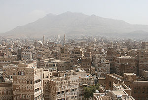 |
Old City of Sana'a Sana'a -Districts:*Al Wahdah District*As Sabain District*Assafi'yah District*At Tahrir District*Ath'thaorah District*Az'zal District*Bani Al Harith District*Ma'ain District*Old City District*Shu'aub District-Old City:... |
Sana Governorate, Yemen |
Cultural: (iv)(v)(vi) |
— | 1986 | Sana’a has been inhabited for more than 2,500 years. In the 7th and 8th centuries the city became a major centre for the propagation of Islam. This religious and political heritage can be seen in the 103 mosques, 14 hammams and over 6,000 houses, all built before the 11th century. | |
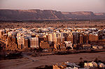 |
Old Walled City of Shibam Shibam Shibam is a town in Yemen with about 7,000 inhabitants. The first known inscription about the city dates from the 3rd century AD... |
Hadhramaut Governorate Hadhramaut Governorate Hadhramaut or Hadramawt is a governorate of Yemen. Lying within the large historical region of Hadhramaut, it is the country's largest governorate.-Overview:... , Yemen |
Cultural: (iii)(iv)(v) |
— | 1982 | The 16th-century city of Shibam is one of the oldest and best examples of urban planning based on the principle of vertical construction. | |
| Socotra Archipelago Socotra Socotra , also spelt Soqotra, is a small archipelago of four islands in the Indian Ocean. The largest island, also called Socotra, is about 95% of the landmass of the archipelago. It lies some east of the Horn of Africa and south of the Arabian Peninsula. The island is very isolated and through... |
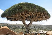 |
Natural: (x) |
410460 (1,014,267.9 acre); buffer zone 1740958 (4,301,997.1 acre) | 2008 | Socotra Archipelago, in the northwest Indian Ocean near the Gulf of Aden, is 250 km long and comprises four islands and two rocky islets which appear as a prolongation of the Horn of Africa. The site is of universal importance because of its biodiversity with rich and distinct flora and fauna. |
Armenia (3)
- Monasteries of HaghpatHaghpat MonasteryHaghpat Monastery, also known as Haghpatavank , is a medieval Armenian monastery complex in Haghpat, Armenia....
and SanahinSanahin MonasterySanahin Monastery is an Armenian monastery founded in the 10th century in the Lori Province of Armenia.The name Sanahin literally translates from Armenian as "this one is older than that one", presumably representing a claim to having an older monastery than the neighbouring Haghpat Monastery...
(1996, 2000) - Cathedral and Churches of Echmiatsin (Saint Hripsime, Saint Gayane, ShoghakatShoghakatThe Church of Shoghakat was erected in 1694 by Prince Aghamal Sorotetsi during the time of Catholicos Nahabed I in the present day city of Vagharshapat , in the Armavir Province of Armenia...
) and the Archaeological Site of ZvartnotsZvartnots CathedralZvartnots Cathedral are the ruins of a seventh century centrally-planned aisled tetraconch type Armenian cathedral built by order of the Catholicos Nerses the Builder from 641-653...
(2000) - Monastery of GeghardGeghardFor the town, see Geghard, Armenia.The monastery of Geghard is a unique architectural construction in the Kotayk province of Armenia, being partially carved out of the adjacent mountain, surrounded by cliffs...
and the Upper Azat Valley (2000)
Azerbaijan (2)
- Walled City of BakuBakuBaku , sometimes spelled as Baki or Bakou, is the capital and largest city of Azerbaijan, as well as the largest city on the Caspian Sea and of the Caucasus region. It is located on the southern shore of the Absheron Peninsula, which projects into the Caspian Sea. The city consists of two principal...
with Shirvanshah's PalacePalace of the ShirvanshahsPalace of the Shirvanshahs is the biggest monument of the Shirvan-Absheron branch of the Azerbaijan architecture, situated in the Inner City of Baku...
and Maiden TowerMaiden Tower (Baku)The Maiden Tower or also known locally as Giz Galasi located in the Old City, Baku in Azerbaijan is an ancient tower with cultural affinity corroborating the presence Zoroastrians, Sassanians, Arabs, Persians, Shirvanis, Ottomans, and Russians...
(2000) - Gobustan Rock Art Cultural Landscape (2007)
Cyprus (3)
- ChoirokoitiaChoirokoitiaKhirokitia is an archaeological site on the island of Cyprus dating from the Neolithic age. It has been listed as a World Heritage Site by UNESCO since 1998....
— 1998 - PaphosPaphosPaphos , sometimes referred to as Pafos, is a coastal city in the southwest of Cyprus and the capital of Paphos District. In antiquity, two locations were called Paphos: Old Paphos and New Paphos. The currently inhabited city is New Paphos. It lies on the Mediterranean coast, about west of the...
(three objects) — 1980- Tombs of the KingsTombs of the Kings (Paphos)The Tombs of the Kings is a large necropolis lying about two kilometres north-west of Paphos harbour in Cyprus...
in Pafos - Sanctuary of Aphrodite in KoukliaKoukliaKouklia is a village in the Paphos District, about from the city of Paphos on the Mediterranean island of Cyprus. The village is built in the area of "Palaepaphos" , mythical birthplace of Aphrodite, Greek goddess of love and beauty...
, Pafos (Palaipafos) - Nea Pafos
- Tombs of the Kings
- Painted Churches in the Troodos RegionPainted Churches in the Troodos RegionThe Painted Churches in the Troödos Region are a UNESCO World Heritage Site in the Troödos Mountains of central Cyprus. The site comprises ten Byzantine churches and monasteries all richly decorated with Byzantine and post-Byzantine murals:...
(ten objects) — 1985, 2001:
-
- Agios Nikolaos Tis Stegis
- Agios Ioannis (St. John) Lampadistis Monastery
- Church of Archangelos Michael
- Church of the Transfiguration of the Saviour
- Panagia Phorviotissa
- Panagia tou Araka
- Panagia tou MoutoullasMoutoullasMoutoullas is a mountain village in Cyprus, located at an altitude of 900m in the Marathasa Valley of the Troodos mountain range.The old village church, the 13th century chapel of Panayia tou Moutoulla is one of the earliest dated examples of the steep-pitched wooden roof type with frescoes built...
- Panagia Podythou
- Timios Stavros (The Holy Cross) in PelendriPelendriPelendri is a village in the Limassol District of Cyprus, located 8 km south of Kyperounta....
- Timios Stavros (The Holy Cross) Agiasmati
Georgia
- Bagrati CathedralBagrati CathedralThe Cathedral of the Dormition, or the Kutaisi Cathedral, more commonly known as Bagrati Cathedral , is the 11th-century cathedral church in the city of Kutaisi, the region of Imereti, Georgia...
and Gelati MonasteryGelati MonasteryThe Monastery of Gelati is a monastic complex near Kutaisi, Imereti, western Georgia. It contains the Church of the Virgin founded by the King of Georgia David the Builder in 1106, and the 13th-century churches of St George and St Nicholas....
— 1994 - Historical Monuments of MtskhetaMtskhetaMtskheta , one of the oldest cities of the country of Georgia , is located approximately 20 kilometers north of Tbilisi at the confluence of the Aragvi and Kura rivers. The city is now the administrative centre of the Mtskheta-Mtianeti region...
— 1994 - Upper SvanetiSvanetiSvaneti is a historic province in Georgia, in the northwestern part of the country. It is inhabited by the Svans, a geographic subgroup of the Georgians.- Geography :...
— 1996
Iran (13)
- Tchogha Zanbil (1979)
- PersepolisPersepolisPerspolis was the ceremonial capital of the Achaemenid Empire . Persepolis is situated northeast of the modern city of Shiraz in the Fars Province of modern Iran. In contemporary Persian, the site is known as Takht-e Jamshid...
(1979) - Naghsh-i Jahan SquareNaghsh-i Jahan SquareNaqsh-e Jahan Square , known as Imam Square , formerly known as Shah Square , is a square situated at the center of Isfahan city, Iran. Constructed between 1598 and 1629, it is now an important historical site, and one of UNESCO's World Heritage Sites...
(1979) - Takht-e Soleyman (2003)
- BamBam, IranBam is a city in and the capital of Bam County, Kerman Province, Iran. At the 2006 census, its population was 73,823, in 19,572 families.The modern Iranian city of Bam surrounds the Bam citadel. Before the 2003 earthquake the official population count of the city was roughly 43,000. There are...
and its Cultural Landscape (2004) - PasargadaePasargadaePasargadae , the capital of Cyrus the Great and also his last resting place, was a city in ancient Persia, and is today an archaeological site and one of Iran's UNESCO World Heritage Sites.-History:...
(2004) - SoltaniyehSoltaniyehSoltaniyeh is a city in and capital of Soltaniyeh District of Abhar County, Zanjan Province, Iran. At the 2006 census, its population was 5,684, in 1,649 families. Soltaniyeh, located some to the north-west of Tehran, used to be the capital of Mongol Ilkhanid rulers of Persia in the 14th century....
(2005) - Behistun InscriptionBehistun InscriptionThe Behistun Inscription The Behistun Inscription The Behistun Inscription (also Bistun or Bisutun, Modern Persian: بیستون The Behistun Inscription (also Bistun or Bisutun, Modern Persian: بیستون...
(2006) - Armenian Monastic Ensembles in Iran, including St Thaddeus, St Stepanos, Chapel of Dzordzor, Chapel of Chupan, and Church of the Holy Mother of GodChurch of the Holy Mother of God, DarashambThe Church of Saint Astvatsatsin is a 17th century Armenian church in the Valley of the Araxes along the Araks river in Iran near Darashamb.- See also :* Saint Stepanos Monastery, an Armenian monastery about 2 kilometers southeast...
(2008) - Shushtar Historical Hydraulic System (2009)
- Tabriz Historic Bazaar Complex (2010)
- Sheikh Safi al-din Khānegāh and Shrine Ensemble in ArdabilArdabilArdabil is a historical city in north-western Iran. The name Ardabil probably comes from the Zoroastrian name of "Artavil" which means a holy place. Ardabil is the center of Ardabil Province. At the 2006 census, its population was 412,669, in 102,818 families...
(2010) - The Persian Gardens, including Chehel SotounChehel SotounChehel Sotoun is a pavilion in the middle of a park at the far end of a long pool, in Isfahan, Iran, built by Shah Abbas II to be used for his entertainment and receptions...
, FinFin GardenFin Garden, or Bagh-e Fin, located in Kashan, Iran, is a historical Persian garden. It contains Kashan's Fin Bath, where Amir Kabir, the Qajarid chancellor, was murdered by an assassin sent by King Nasereddin Shah in 1852.-History:...
, EramEram GardenEram Garden |Bāgh]] of Eram") is a historic Persian garden in Shiraz, Iran. Eram is the Persianized version of the Arabic word "Iram" meaning heaven in the Muslim's book of Koran. Eram Garden therefore is so called for its beauties and aesthetic attractions resembling "heaven." This garden is...
, ShazdehShazdeh GardenShazdeh Garden meaning Prince’s Garden is a historical Persian garden located near Mahan in Kerman province, Iran.The garden is 5.5 hectares with a rectangular shape and a wall around it. It consists of an entrance structure and gate at the lower end and a two-floor residential structure at the...
, Pasargad Pserian, Dolatabad, Abbasabad, Akbarieh and Pahlevanpour (2011)
Israel (6)
- (also included under Europe)
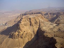
- MasadaMasadaMasada is the name for a site of ancient palaces and fortifications in the South District of Israel, on top of an isolated rock plateau, or horst, on the eastern edge of the Judean Desert, overlooking the Dead Sea. Masada is best known for the violence that occurred there in the first century CE...
(2001) - Old City of Acre (2001)
- White City of Tel Aviv (2003)
- Biblical TelsTellA tell or tel, is a type of archaeological mound created by human occupation and abandonment of a geographical site over many centuries. A classic tell looks like a low, truncated cone with a flat top and sloping sides.-Archaeology:A tell is a hill created by different civilizations living and...
– Tel Megiddo, Tel Hazor, Tel Be'er ShevaTel Be'er ShevaTel Be'er Sheva is an archeological site in southern Israel believed to be the remains of the biblical town of Beersheba. It lies to the east of the modern city of Beersheba and to the east of the Bedouin town of Tel Sheva.-Biblical Beersheba:...
(2005) - Incense Route – Desert Cities in the NegevIncense Route – Desert Cities in the NegevIncense Route – Desert Cities in the Negev is a World Heritage-designated itinerary in the Negev, southern Israel. The site of patrimony was proclaimed of outstanding universal value by UNESCO in 2005....
(2005) - Baha'i Holy PlacesBahá'í World Centre buildingsThe Bahá'í World Centre buildings are buildings that are part of the Bahá'í World Centre in Israel. The Bahá'í World Centre buildings include both the Bahá'í holy places used for pilgrimage and the international administrative bodies of the Bahá'í Faith; they comprise more than 20 different...
in HaifaHaifaHaifa is the largest city in northern Israel, and the third-largest city in the country, with a population of over 268,000. Another 300,000 people live in towns directly adjacent to the city including the cities of the Krayot, as well as, Tirat Carmel, Daliyat al-Karmel and Nesher...
and Western GalileeGalileeGalilee , is a large region in northern Israel which overlaps with much of the administrative North District of the country. Traditionally divided into Upper Galilee , Lower Galilee , and Western Galilee , extending from Dan to the north, at the base of Mount Hermon, along Mount Lebanon to the...
(2008)
- Masada
Turkey (10)
- Göreme National ParkGöremeGöreme , located among the "fairy chimney" rock formations, is a town in Cappadocia, a historical region of Turkey. It is in the Nevşehir Province in Central Anatolia and has a population of around 2,500 people....
and the Rock Sites of CappadociaCappadociaCappadocia is a historical region in Central Anatolia, largely in Nevşehir Province.In the time of Herodotus, the Cappadocians were reported as occupying the whole region from Mount Taurus to the vicinity of the Euxine...
(1985) - Great Mosque and HospitalDivrigi Great MosqueDivriği Great Mosque and Hospital is an ornately decorated mosque and medical complex built in 1299 in the small eastern Anatolian mountain town of Divriği, now in Sivas Province in Turkey. The architect was Hürremshah of Ahlat and the mosque was built on the order of Ahmet Shah, ruler of the...
of DivriğiDivrigiDivriği is a town and a district of Sivas Province of Turkey. The town lies on gentle slope on the south bank of the Çaltısuyu river, a tributary of the Karasu river....
(1985) - Historic Areas of IstanbulIstanbulIstanbul , historically known as Byzantium and Constantinople , is the largest city of Turkey. Istanbul metropolitan province had 13.26 million people living in it as of December, 2010, which is 18% of Turkey's population and the 3rd largest metropolitan area in Europe after London and...
(1985) - HattusaHattusaHattusa was the capital of the Hittite Empire in the late Bronze Age. It was located near modern Boğazkale, Turkey, within the great loop of the Kızıl River ....
: the HittiteHittitesThe Hittites were a Bronze Age people of Anatolia.They established a kingdom centered at Hattusa in north-central Anatolia c. the 18th century BC. The Hittite empire reached its height c...
Capital (1986) - Nemrut Dağ (1987)
- HierapolisHierapolisHierapolis was the ancient Greco-Roman city which sat on top of hot springs located in south western Turkey near Denizli....
–PamukkalePamukkalePamukkale, meaning "cotton castle" in Turkish, is a natural site in Denizli Province in southwestern Turkey. The city contains hot springs and travertines, terraces of carbonate minerals left by the flowing water...
(1988) - XanthosXanthosXanthos was the name of a city in ancient Lycia, the site of present day Kınık, Antalya Province, Turkey, and of the river on which the city is situated...
–LetoonLetoonThe Letoon , sometimes Latinized as Letoum, was a sanctuary of Leto near the ancient city Xanthos that was one of the most important religious centres of the Lycian region in Anatolia...
(1988) - City of SafranboluSafranboluSafranbolu is a town and district of Karabük Province in the Black Sea region of Turkey. It is about two hundred kilometers north of Ankara and about a hundred kilometers south of the Black Sea coast, or more precisely about 9 kilometers north of the city of Karabük...
(1994) - Archaeological Site of TroyTroyTroy was a city, both factual and legendary, located in northwest Anatolia in what is now Turkey, southeast of the Dardanelles and beside Mount Ida...
(1998) - Selimiye MosqueSelimiye MosqueThe Selimiye Mosque is an Ottoman mosque in the city of Edirne, Turkey. The mosque was commissioned by Sultan Selim II and was built by architect Mimar Sinan between 1569 and 1575...
and its Social Complex (2011)
United Arab Emirates (1)
- Cultural Sites of Al AinAl AinAl Ain |Spring]]), also known as the Garden City due to its greenery, is the second largest city in the Emirate of Abu Dhabi and the fourth largest city in the United Arab Emirates. With a population of 374,000 , it is located approximately 160 km east of the capital Abu Dhabi and about...
(Hafit, HiliHili Archaeological ParkHili Archaeological Park is the location of a Bronze Age site in Al Ain, Emirate of Abu Dhabi, United Arab Emirates.Hili is the largest Bronze Age site in the UAE and dates from the 3rd millennium BC. Other remains include settlements, tombs, and a falaj dating from the Iron Age. Some of the site...
, Bidaa Bint Saud and Oases Areas, United Arab Emirates (2011)