

List of National Natural Landmarks in Washington
Encyclopedia
From List of National Natural Landmarks, these are the National Natural Landmark
s in Washington. There are 17 in total, X are lakes or pond, Y are forests, Z are other.
National Natural Landmark
The National Natural Landmark program recognizes and encourages the conservation of outstanding examples of the natural history of the United States. It is the only natural areas program of national scope that identifies and recognizes the best examples of biological and geological features in...
s in Washington. There are 17 in total, X are lakes or pond, Y are forests, Z are other.
| Name | Image | Date | Location | County | Description | |
|---|---|---|---|---|---|---|
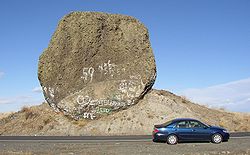
| 1 | Boulder Park Boulder Park Boulder Park National Natural Landmark, along with the nearby Natural Landmarks McNeil Canyon Haystack Rocks and Sims Corner Eskers and Kames comprise several of the best examples of Pleistocene ice stagnation landforms in Washington. Feature include numerous glacial erratics near and on the... and McNeil Canyon Haystack Rocks |
Douglas County | The most illustrative examples of glacial erratics in the United States. | |||
| 2 | Davis Canyon | Okanogan | One of the largest and least disturbed examples of antelope bitterbrush-Idaho fescue shrub steppe remaining in the Columbia Plateau. | |||
| 3 | Drumheller Channels Drumheller Channels National Natural Landmark Drumheller Channels National Natural Landmark showcases the Drumheller Channels, which are the most significant example in the Columbia Plateau of basalt butte-and-basin channeled scablands... |
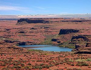 |
Adams, Grant | Illustrates the dramatic modification of the Columbia Plateau volcanic terrain by late Pleistocene Pleistocene The Pleistocene is the epoch from 2,588,000 to 11,700 years BP that spans the world's recent period of repeated glaciations. The name pleistocene is derived from the Greek and .... catastrophic glacial outburst floods. |
||
| 4 | Ginkgo Petrified Forest Ginkgo/Wanapum State Park Ginkgo Petrified Forest State Park/Wanapum Recreational Area is a state park at Vantage, Washington including 27,000 feet of freshwater shoreline on the Wanapum Reservoir on the Columbia River. Petrified wood was discovered in the region in the early 1930s, which led to creation of the park... |
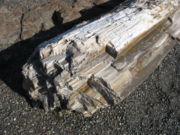 |
Kittitas | Thousands of logs petrified in lava flows. | ||
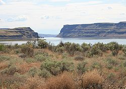
| 5 | Grand Coulee Grand Coulee The Grand Coulee is an ancient river bed in the U.S. state of Washington. This National Natural Landmark stretches for about sixty miles southwest from Grand Coulee Dam to Soap Lake, being bisected by Dry Falls into the Upper and Lower Grand Coulee.... |
 |
Grant | An illustration of a series of geological events. | ||
| 6 | Grande Ronde Feeder Dikes | Asotin | The best example of basalt dikes, the congealed feeder sources of the Columbia River Columbia River The Columbia River is the largest river in the Pacific Northwest region of North America. The river rises in the Rocky Mountains of British Columbia, Canada, flows northwest and then south into the U.S. state of Washington, then turns west to form most of the border between Washington and the state... basalt Basalt Basalt is a common extrusive volcanic rock. It is usually grey to black and fine-grained due to rapid cooling of lava at the surface of a planet. It may be porphyritic containing larger crystals in a fine matrix, or vesicular, or frothy scoria. Unweathered basalt is black or grey... plateau. |
|||
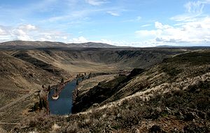
| 7 | Grande Ronde Goosenecks | Asotin | A 1500 feet (457.2 m) deep canyon that follows a tortuous path along meanders. | |||
| 8 | The Great Gravel Bar of Moses Coulee Moses Coulee Moses Coulee cuts into the Waterville plateau in Douglas County, Washington. It is to the west of and roughly parallel to the more famous Grand Coulee... |
Douglas County | Largest and best example of a pendent river bar formed by catastrophic glacial outburst floods that swept across the Columbia Plateau. | |||
| 9 | Mima Mounds Mima Mounds Mima mounds is a term used for low, flattened, circular to oval, domelike, natural mounds found in the northwestern United States, Idaho, Oregon, and Washington, that are composed of loose, unstratified, often gravelly sediment that is an overthickened A Horizon... |
Thurston | A prairie containing unusual soil pimples of black silt-gravel. | |||
| 10 | Nisqually Delta Nisqually River The Nisqually River is a river in west central Washington in the United States, approximately long. It drains part of the Cascade Range southwest of Tacoma, including the southern slope of Mount Rainier, and empties into the southern end of Puget Sound.... |
Pierce Pierce County, Washington right|thumb|[[Tacoma, Washington|Tacoma]] - Seat of Pierce CountyPierce County is the second most populous county in the U.S. state of Washington. Formed out of Thurston County on December 22, 1852, by the legislature of Oregon Territory... , Thurston |
An unusually fine example of an estuarine ecosystem. | |||
| 11 | Point of Arches | Clallam | An outstanding exhibit of sea action in sculpturing a rocky shoreline | |||
| 12 | Rose Creek Preserve | Whitman Whitman County, Washington Whitman County is a county located in the U.S. state of Washington. As of the 2010 census, the population was 44,776, with the majority living in its largest city, Pullman, home to Washington State University, the state's land-grant university. The county seat is at Colfax.Whitman County was... |
The best remaining example of the aspen phase of the hawthorne-cow parsnip habitat type in the Columbia Plateau. | |||
| 13 | Sims Corner Eskers and Kames Sims Corner Eskers and Kames The Sims Corner Eskers and Kames National Natural Landmark includes excellent examples of Pleistocene ice stagnation landforms including numerous glacial erratics, terminal moraines, eskers, and kames... |
 |
Douglas County | The best examples in the Columbia Plateau of landforms resulting from stagnation and rapid retreat of the ice sheet during the last glaciation. | ||
| 14 | Steptoe Steptoe Butte Steptoe Butte is a quartzite island jutting out of the silty loess of the Palouse hills in Whitman County, Washington. It is contained by Steptoe Butte State Park. The rock that forms the butte is over 400 million years old, in contrast with the 15–7 million year old Columbia River basalts that... and Kamiak Butte Kamiak Butte Kamiak Butte County Park is located in Whitman County, Washington between the towns of Palouse and Pullman in Eastern Washington, near the border of Idaho. It is named after Chief Kamiakin of the Yakama tribe.... s |
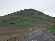 |
Whitman Whitman County, Washington Whitman County is a county located in the U.S. state of Washington. As of the 2010 census, the population was 44,776, with the majority living in its largest city, Pullman, home to Washington State University, the state's land-grant university. The county seat is at Colfax.Whitman County was... |
Isolated mountain peaks of older rock surrounded by basalt, rising above the surrounding lava plateau. | ||
| 15 | Umtanum Ridge Water Gap Umtanum Ridge Water Gap Umtanum Ridge Water Gap is a geologic feature in central Washington State in the United States.The Umtanum Ridge Water is a water gap cut by the Yakima River through Manastash and Umtanum Ridge anticlines, which are part of the Yakima Fold Belt near the western edge of the Columbia River Plateau... |
 |
Kittitas | Illustrates the geological processes of tectonic folding and antecedent stream cutting. | ||
| 16 | Wallula Gap Wallula Gap Wallula Gap is a large water gap of the Columbia River through basalt anticlines in the Columbia River Basin in the U.S. state of Washington, just south of the confluence of the Walla Walla and Columbia rivers... |
 |
Benton Benton County, Washington Benton County is a county located in the south-central portion of the U.S. state of Washington. The Columbia River makes up the north, south, and east boundaries of the county. In 2010, its population was 175,177. The county seat is Prosser, and its largest city is Kennewick... , Walla Walla |
The largest and most spectacular of several large water gaps through basalt anticlines in the Columbia River basin. | ||
| 17 | Withrow Moraine and Jameson Lake Drumlin Field Withrow Moraine and Jameson Lake Drumlin Field The Withrow Moraine and Jameson Lake Drumlin Field is a National Park Service designated privately-owned National Natural Landmark located in Douglas County, Washington state, United States. Withrow Moraine is the only Ice Age terminal moraine on the Waterville Plateau section of the Columbia... |
 |
Douglas County | The best examples of drumlins and the most illustrative segment of the only Pleistocene Pleistocene The Pleistocene is the epoch from 2,588,000 to 11,700 years BP that spans the world's recent period of repeated glaciations. The name pleistocene is derived from the Greek and .... terminal moraine Moraine A moraine is any glacially formed accumulation of unconsolidated glacial debris which can occur in currently glaciated and formerly glaciated regions, such as those areas acted upon by a past glacial maximum. This debris may have been plucked off a valley floor as a glacier advanced or it may have... in the Columbia Plateau |
||