

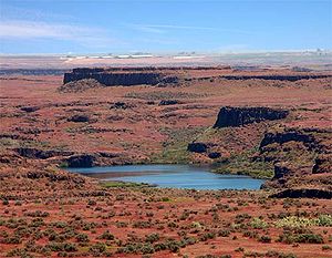
Drumheller Channels National Natural Landmark
Encyclopedia
Columbia Plateau
The Columbia Plateau is a geologic and geographic region that lies across parts of the U.S. states of Washington, Oregon, and Idaho. It is a wide flood basalt plateau between the Cascade Range and the Rocky Mountains, cut through by the Columbia River...
of basalt butte-and-basin channeled scablands
Channeled scablands
The Channeled Scablands are a unique geological erosion feature in the U.S. state of Washington. They were created by the cataclysmic Missoula Floods that swept periodically across eastern Washington and down the Columbia River Plateau during the Pleistocene epoch. Geologist J Harlen Bretz coined...
. This National Natural Landmark
National Natural Landmark
The National Natural Landmark program recognizes and encourages the conservation of outstanding examples of the natural history of the United States. It is the only natural areas program of national scope that identifies and recognizes the best examples of biological and geological features in...
is an extensively eroded landscape, located in south central Washington state characterized by hundreds of isolated, steep-sided hills (buttes) surrounded by a braided network of numerous channels, all but one of which are currently dry. It is a classic example of the tremendous erosive powers of extremely large floods such as those that reformed the Columbia Plateau volcanic terrain during the late Pleistocene
Pleistocene
The Pleistocene is the epoch from 2,588,000 to 11,700 years BP that spans the world's recent period of repeated glaciations. The name pleistocene is derived from the Greek and ....
glacial Missoula Floods
Missoula Floods
The Missoula Floods refer to the cataclysmic floods that swept periodically across eastern Washington and down the Columbia River Gorge at the end of the last ice age. The glacial flood events have been researched since the 1920s...
.
In 1986, the U.S. National Park Service recognized the significance and natural beauty of Drumheller Channels by designating them a National Natural Landmark
National Natural Landmark
The National Natural Landmark program recognizes and encourages the conservation of outstanding examples of the natural history of the United States. It is the only natural areas program of national scope that identifies and recognizes the best examples of biological and geological features in...
. The geologist who initially recognized and documented the evidence for the Ice-Age floods, J Harlen Bretz, wrote:
“Drumheller is the most spectacular tract of butte-and basin scabland on the plateau. It is an almost unbelievable labyrinth of anastamosing channels, rock basins, and small abandoned cataracts”.
Drumheller Channels connects the Quincy Basin, which lies to north, with the Othello Basin on the south. It can be reached most easily from Othello, Washington
Othello, Washington
Othello is a city in Adams County, Washington, United States. The population was 5,847 at the 2000 census and grew 25.9% over the next decade to 7,364 at the 2010 census. Othello refers to the city as being in the "Heart" of the Columbia Basin Project...
approximately 8 km (5 mi) northwest on McManamon Road, then north on Morgan Lake Road which passes through the Drumheller Channels region. The north/south Morgan Lake Road (gravel) passes through the heart of the channels following Crab Creek
Crab Creek
Crab Creek is a stream in the U.S. state of Washington. Named for the presence of crayfish, it is one of the few perennial streams in the Columbia Basin of central Washington, flowing from the northeastern Columbia River Plateau, roughly east of Reardan, west-southwest to empty into the Columbia...
. Hikes can be taken, including an interpretive trail, from the wetlands along Crab Creek to the views from an isolated butte, that allow the hiker to gain a sense of this unique landscape. The Drumheller Channels can also be seen from the paved State Route 262 which runs to the north of the area along the top of the Potholes Reservoir dam (which has inundated part of the scablands) and from the west side from the heights of the Frenchman Hills.
Route of the ancient Columbia River
Cordilleran Ice Sheet
The Cordilleran ice sheet was a major ice sheet that covered, during glacial periods of the Quaternary, a large area of North America. This included the following areas:*Western Montana*The Idaho Panhandle...
moved down the Okanogan River
Okanogan River
The Okanogan River is a tributary of the Columbia River, approximately 115 mi long, in southern British Columbia and north central Washington...
valley and blocked the ancient route of the Columbia River
Columbia River
The Columbia River is the largest river in the Pacific Northwest region of North America. The river rises in the Rocky Mountains of British Columbia, Canada, flows northwest and then south into the U.S. state of Washington, then turns west to form most of the border between Washington and the state...
, backing up water to create Lake Spokane. Initially water discharged from Lake Spokane by running up through the head of Grand Coulee and down through Foster Coulee to rejoin the Columbia River. As the glacier moved further south, Foster Coulee was cut off and the Columbia River then discharged through Moses Coulee
Moses Coulee
Moses Coulee cuts into the Waterville plateau in Douglas County, Washington. It is to the west of and roughly parallel to the more famous Grand Coulee...
, which runs southward slightly to the east of the ancient and current course of the Columbia. As the Okanogan lobe grew, it blocked Moses Coulee as well; the Columbia found the next lowest route through the region which was eroded to become the modern Grand Coulee
Grand Coulee
The Grand Coulee is an ancient river bed in the U.S. state of Washington. This National Natural Landmark stretches for about sixty miles southwest from Grand Coulee Dam to Soap Lake, being bisected by Dry Falls into the Upper and Lower Grand Coulee....
. Flowing across the current Grand Coulee & Dry Falls regions, the ice age Columbia then entered the Quincey Basin & joined Crab Creek, following Crab Creek’s course southward past the Frenchman Hills and turning west to run along the north face of the Saddle Mountains
Saddle Mountains
The Saddle Mountains consists of an upfolded anticline ridge of basalt in Grant County of central Washington state. The ridge, reaching to 2,700 feet, terminates in the east south of Othello, Washington near the foot of the Drumheller Channels...
& rejoin the previous and modern course of the Columbia River just above the main water gap in the Saddle Mountains, Sentinel Gap.
Formation of the Drumheller Channels
The Missoula FloodsMissoula Floods
The Missoula Floods refer to the cataclysmic floods that swept periodically across eastern Washington and down the Columbia River Gorge at the end of the last ice age. The glacial flood events have been researched since the 1920s...
discharged into Lake Spokane, through the Grand Coulee
Grand Coulee
The Grand Coulee is an ancient river bed in the U.S. state of Washington. This National Natural Landmark stretches for about sixty miles southwest from Grand Coulee Dam to Soap Lake, being bisected by Dry Falls into the Upper and Lower Grand Coulee....
, greatly enlarging it, passed over Dry Falls
Dry Falls
Dry Falls is a 3.5 mile long scalloped precipice in central Washington, on the opposite side of the Upper Grand Coulee from the Columbia River, and at the head of the Lower Grand Coulee. Ten times the size of Niagara, Dry Falls is thought to be the greatest known waterfall that ever existed...
and then ponded in and inundated the Quincy Basin, covering over 1500 km² (585 mi²) and creating the Ephrata Fan (a deposit of boulders, cobbles, and pebbles where the flood waters discharged into the basin). The discharge volume was so great that water overflowed Lake Spokane in multiple places & also reached the Quincy Basin via the Telford-Crab Creek scablands and Lind Coulee (both entering the basin from the east). When floodwaters encountered the Frenchman Hills, their level was high enough that, although the bulk of the water passed through the Crab Creek drainage, some water spilled west over the low points of three divides along Evergreen and Babcock ridges to reach the Columbia river channel at Frenchman Coulee to the southwest, Potholes Coulee to the north central and Crater Coulee to the northwest. The bulk of the floodwaters took the easiest path, straight south through the Drumheller Channels stretch of Crab Creek.
The elevation drop of the floodwaters as they passed through the Drumheller Channels was greater than 50 meters (160 ft) over a distance of 20 km (12.4 mi) with gradiants locally ranging from 2–12 m/km). This hydraulic head combined with a flow depth of from 60 to 120 meters (200 – 400 ft) provided the energy to achieve flood flow velocities as high as 30 m/s (65 mph), which eroded the topsoil and underlying basalt, gouging the complex network of channels, basins, potholes and buttes that are found there even today. Examples of scabland features, such as large kolk
Kolk
A kolk is an underwater vortex that is created when rapidly rushing water passes an underwater obstacle in boundary areas of high shear. High velocity gradients produce a violently rotating column of water, similar to a tornado. Kolks are capable of plucking multi-ton blocks of rock and...
-excavated potholes provide evidence of the tremendous powers of the floods.
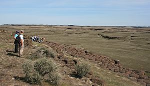
There is a unique character to the Drumheller Channels; unlike most other Channeled Scabland zones, no single centralized channel or major cataracts were formed. In the Drumheller Channels the floodwaters passing through in a broad cascade of 13 – 20 km (8 to 12 miles) in width. Bretz recorded 150 distinct channels and over 180 rock basins in this region. Many of the low areas, including Upper Goose Lake, are filled by water seeping in through cracks in the basalt bedrock, which are connected with Potholes Reservoir to the north.
Impacts of early settlement
The impact of settlement was severe; in the 1860s overgrazing depleted most of the few native grasses. Government surveys of the 1880s identified much of the region as badlands.Bureau of Reclamation actions
In 1934, the U.S. Bureau of Reclamation initiated construction on the Grand Coulee DamGrand Coulee Dam
Grand Coulee Dam is a gravity dam on the Columbia River in the U.S. state of Washington built to produce hydroelectric power and provide irrigation. It was constructed between 1933 and 1942, originally with two power plants. A third power station was completed in 1974 to increase its energy...
on the Columbia River about 100 miles (160.9 km) north of the Drumheller Channels. Grand Coulee was only one part of the Columbia Basin Project
Columbia Basin Project
The Columbia Basin Project in Central Washington, USA, is the irrigation network that the Grand Coulee Dam makes possible. It is the largest water reclamation project in the United States, supplying irrigation water to over of the large project area, all of which was originally intended to be...
, which included four major storage reservoirs, hundreds of pumping plants, 2300 miles (3,701.5 km) of canals and laterals to irrigate the region. Irrigation began in 1951, raising the water table. By 1980, when the last stage of the project was completed, the area of wetlands in the Columbia Basin was at least 20 times larger than it had been earlier as a result of seepage and a raised water table. Migrating waterfowl were drawn to the region by the water and by greatly increased food supplies from the adjacent farmlands.
Columbia National Wildlife Refuge
The Columbia National Wildlife RefugeColumbia National Wildlife Refuge
Columbia National Wildlife Refuge is a scenic mixture of rugged cliffs, canyons, lakes, and sagebrush grasslands. Formed by fire, ice, floods, and volcanic tempest, carved by periods of extreme violence of natural forces, the refuge lies in the middle of the Drumheller Channeled Scablands of...
is collocated with the Drumheller Channels. Adjacent areas are included in the Seep Lakes Wildlife Area. More than 200 species of mammals and birds can be found in the cliffs, marshes, grasslands, lakes, seeps, and other riparian areas.
External links
- National Park Service List of National Natural Landmark in Washington
- National Park Service article on Ice Age Floods
- Site of the Ice-Age Floods Institute (IAFI). The IAFI is a non-profit organization educating the public about geologic events that shaped the Pacific Northwest.
- Columbia National Wildlife Refuge