

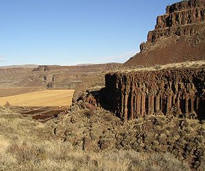
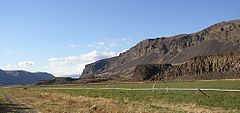
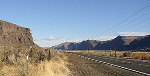
Moses Coulee
Encyclopedia
Grand Coulee
The Grand Coulee is an ancient river bed in the U.S. state of Washington. This National Natural Landmark stretches for about sixty miles southwest from Grand Coulee Dam to Soap Lake, being bisected by Dry Falls into the Upper and Lower Grand Coulee....
. The mouth of Moses Coulee discharges into the Columbia River
Columbia River
The Columbia River is the largest river in the Pacific Northwest region of North America. The river rises in the Rocky Mountains of British Columbia, Canada, flows northwest and then south into the U.S. state of Washington, then turns west to form most of the border between Washington and the state...
at the Great Gravel Bar of Moses Coulee, a National Natural Landmark
National Natural Landmark
The National Natural Landmark program recognizes and encourages the conservation of outstanding examples of the natural history of the United States. It is the only natural areas program of national scope that identifies and recognizes the best examples of biological and geological features in...
which was designated a landmark because it is one the largest examples of bars created by outburst floods
Missoula Floods
The Missoula Floods refer to the cataclysmic floods that swept periodically across eastern Washington and down the Columbia River Gorge at the end of the last ice age. The glacial flood events have been researched since the 1920s...
of Lake Missoula over the Channeled Scablands
Channeled scablands
The Channeled Scablands are a unique geological erosion feature in the U.S. state of Washington. They were created by the cataclysmic Missoula Floods that swept periodically across eastern Washington and down the Columbia River Plateau during the Pleistocene epoch. Geologist J Harlen Bretz coined...
of Washington. (Coordinates: lower coulee-47°22′30"N 120°00′00"W middle coulee 47°27′30"N 119°48′00"W upper coulee - 47°37′30"N 119°42′00"W ).
Geologic history
The plateau
Moses Coulee cuts into the Waterville Plateau, which lies in the northwest corner of the Columbia River PlateauColumbia River Plateau
The Columbia Plateau is a geologic and geographic region that lies across parts of the U.S. states of Washington, Oregon, and Idaho. It is a wide flood basalt plateau between the Cascade Range and the Rocky Mountains, cut through by the Columbia River...
. The plateau is formed on top of the Columbia River Basalt Group
Columbia River Basalt Group
The Columbia River Basalt Group is a large igneous province that lies across parts of the Western United States. It is found in the U.S. states of Washington, Oregon, Idaho, Nevada, and California...
a large igneous province
Large igneous province
A Large Igneous Province is an extremely large accumulation of igneous rocks—intrusive, extrusive, or both—in the earth's crust...
that lies across parts of the states of Washington, Oregon
Oregon
Oregon is a state in the Pacific Northwest region of the United States. It is located on the Pacific coast, with Washington to the north, California to the south, Nevada on the southeast and Idaho to the east. The Columbia and Snake rivers delineate much of Oregon's northern and eastern...
, and Idaho
Idaho
Idaho is a state in the Rocky Mountain area of the United States. The state's largest city and capital is Boise. Residents are called "Idahoans". Idaho was admitted to the Union on July 3, 1890, as the 43rd state....
in the United States of America. During late Miocene
Miocene
The Miocene is a geological epoch of the Neogene Period and extends from about . The Miocene was named by Sir Charles Lyell. Its name comes from the Greek words and and means "less recent" because it has 18% fewer modern sea invertebrates than the Pliocene. The Miocene follows the Oligocene...
and early Pliocene
Pliocene
The Pliocene Epoch is the period in the geologic timescale that extends from 5.332 million to 2.588 million years before present. It is the second and youngest epoch of the Neogene Period in the Cenozoic Era. The Pliocene follows the Miocene Epoch and is followed by the Pleistocene Epoch...
times, one of the largest flood basalt
Flood basalt
A flood basalt or trap basalt is the result of a giant volcanic eruption or series of eruptions that coats large stretches of land or the ocean floor with basalt lava. Flood basalts have occurred on continental scales in prehistory, creating great plateaus and mountain ranges...
s ever to appear on the earth
Earth
Earth is the third planet from the Sun, and the densest and fifth-largest of the eight planets in the Solar System. It is also the largest of the Solar System's four terrestrial planets...
's surface engulfed about 163,700 km² (63,000 mile²) of the Pacific Northwest, forming a large igneous province
Large igneous province
A Large Igneous Province is an extremely large accumulation of igneous rocks—intrusive, extrusive, or both—in the earth's crust...
with an estimated volume of 174,300 km³. Eruptions were most vigorous from 17—14 million years ago, when over 99% of the basalt was released. Less extensive eruptions continued from 14—6 million years ago.
These lava flows have been extensively exposed by the erosion resulting from the Missoula Floods
Missoula Floods
The Missoula Floods refer to the cataclysmic floods that swept periodically across eastern Washington and down the Columbia River Gorge at the end of the last ice age. The glacial flood events have been researched since the 1920s...
, which laid bare many layers of the basalt flows on the edges of the plateau along the course of Moses Coulee.
The glacial history
Pleistocene
The Pleistocene is the epoch from 2,588,000 to 11,700 years BP that spans the world's recent period of repeated glaciations. The name pleistocene is derived from the Greek and ....
epoch began and Ice age
Ice age
An ice age or, more precisely, glacial age, is a generic geological period of long-term reduction in the temperature of the Earth's surface and atmosphere, resulting in the presence or expansion of continental ice sheets, polar ice sheets and alpine glaciers...
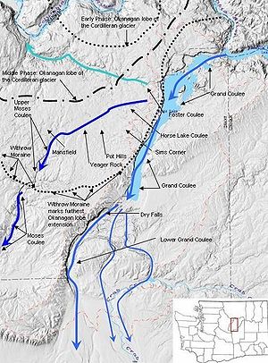
glaciers invaded the area. They scoured the Columbia River Plateau, reaching as far south as the middle of the Waterville Plateau highlands above the Grand Coulee and south to the head of Moses Coulee. In some areas north of the Grand Coulee they were as much as 3 km (10000 ft) thick. Grooves in the exposed granite bedrock are still visible in the area from the movement of glaciers and numerous glacial erratic
Glacial erratic
A glacial erratic is a piece of rock that differs from the size and type of rock native to the area in which it rests. "Erratics" take their name from the Latin word errare, and are carried by glacial ice, often over distances of hundreds of kilometres...
s in the elevated regions to the Northwest of the coulee. The south terminus of the Okanogan lobe is clearly marked by an abrupt south limit of lumpy, rocky moraines which can be seen while driving thorough the area or from satellite photography. The ice-dammed Columbia River backed up to form Glacial Lake Columbia
Glacial Lake Columbia
Glacial Lake Columbia was the lake formed on the ice-dammed Columbia River behind the Okanogan lobe of the Cordilleran Ice Sheet when the lobe covered of the Waterville Plateau west of Grand Coulee in central Washington state during the Wisconsin glaciation. Lake Columbia was a substantially...
and Lake Spokane, larger lakes than Lake Roosevelt, which is currently backed up in the same location behind the Grand Coulee Dam. The overflow of these glacial lakes created Moses Coulee.
Creation of Moses Coulee
The Okanogan lobe of the Cordilleran Glacier
Cordilleran Ice Sheet
The Cordilleran ice sheet was a major ice sheet that covered, during glacial periods of the Quaternary, a large area of North America. This included the following areas:*Western Montana*The Idaho Panhandle...
moved down the Okanogan River
Okanogan River
The Okanogan River is a tributary of the Columbia River, approximately 115 mi long, in southern British Columbia and north central Washington...
valley, covering 500 mi² of the Waterville Plateau and blocked the ancient route of the Columbia River, backing up water to create Glacial Lake Columbia
Glacial Lake Columbia
Glacial Lake Columbia was the lake formed on the ice-dammed Columbia River behind the Okanogan lobe of the Cordilleran Ice Sheet when the lobe covered of the Waterville Plateau west of Grand Coulee in central Washington state during the Wisconsin glaciation. Lake Columbia was a substantially...
and Lake Spokane. Initially water discharged from Lake Columbia by running up through the head of Grand Coulee and down through Foster Coulee to rejoin the Columbia River. As the glacier moved further south, Foster Coulee was cut off and the Columbia River then discharged through Moses Coulee, which runs southward slightly to the east of the ancient and current course of the Columbia. As the Okanogan lobe grew, it blocked Moses Coulee as well; the Columbia found the next lowest route through the region which was eroded to become the modern Grand Coulee
Grand Coulee
The Grand Coulee is an ancient river bed in the U.S. state of Washington. This National Natural Landmark stretches for about sixty miles southwest from Grand Coulee Dam to Soap Lake, being bisected by Dry Falls into the Upper and Lower Grand Coulee....
. Flowing across the current Grand Coulee & Dry Falls regions, the ice age Columbia then entered the Quincey Basin & joined Crab Creek, following Crab Creek’s course southward past the Frenchman Hills and turning west to run along the north face of the Saddle Mountains
Saddle Mountains
The Saddle Mountains consists of an upfolded anticline ridge of basalt in Grant County of central Washington state. The ridge, reaching to 2,700 feet, terminates in the east south of Othello, Washington near the foot of the Drumheller Channels...
& rejoin the previous and modern course of the Columbia River just above the main water gap in the Saddle Mountains, Sentinel Gap.
Although the Columbia River flowed only for a short period through Moses Coulee, this period included one or more of the tremendous flows from the Missoula Floods
Missoula Floods
The Missoula Floods refer to the cataclysmic floods that swept periodically across eastern Washington and down the Columbia River Gorge at the end of the last ice age. The glacial flood events have been researched since the 1920s...
.
After the glacier
As the Okanogan lobe melted, the upper portions of Moses Coulee were littered with clear evidence of its passing in the Withrow MoraineWithrow Moraine and Jameson Lake Drumlin Field
The Withrow Moraine and Jameson Lake Drumlin Field is a National Park Service designated privately-owned National Natural Landmark located in Douglas County, Washington state, United States. Withrow Moraine is the only Ice Age terminal moraine on the Waterville Plateau section of the Columbia...
. The glacier left behind a blanket of glacial till, up to 50 feet (15.2 m) thick in places. This glacial till, made up of clay, silt, sand, gravel, cobblestones, and erratic
Erratic
Erratic can refer to:* Erratic, a project of music artist Jan Robbe* Glacial erratic, is a piece of rock that differs from the size and type of rock native to the area in which it rests* Erratic ant, a species...
boulders, covers most of the upper coulee.
Today Moses Coulee supports an excellent example of a shrub-steppe
Shrub-steppe
Shrub-steppe is a type of low rainfall natural grassland. Shrub-steppes are distinguishable from deserts, which are too dry to support a noticeable cover of perennial grasses or other shrubs, while the shrub-steppe has sufficient moisture levels to support a cover of perennial grasses and/or...
ecoregion. Vegetation includes sagebrush
Artemisia (plant)
Artemisia is a large, diverse genus of plants with between 200 to 400 species belonging to the daisy family Asteraceae. It comprises hardy herbs and shrubs known for their volatile oils. They grow in temperate climates of the Northern Hemisphere and Southern Hemisphere, usually in dry or semi-dry...
, rabbitbrush
Rabbitbrush
Rabbitbrush is a common name for plants in two related genera of the family Asteraceae:* Chrysothamnus — most species, including Green Rabbitbrush* Ericameria — Gray and Parry's Rabbitbrush...
, greasewood
Greasewood
Greasewood, Sarcobatus, is a genus of one or two species of flowering plants. Traditionally it has been treated in the family Chenopodiaceae, but the APG II system, of 2003, places it in the family Sarcobataceae....
, hopsage, bitterbrush, bunchgrass, buckwheat
Buckwheat
Buckwheat refers to a variety of plants in the dicot family Polygonaceae: the Eurasian genus Fagopyrum, the North American genus Eriogonum, and the Northern Hemisphere genus Fallopia. Either of the latter two may be referred to as "wild buckwheat"...
and other vegetation once common to most of the Colubia Plateau.
Moses Coulee Preserve
The Nature Conservancy has established the Moses Coulee Preserve, which is a 3588 acres (14.5 km²) contiguous, intact shrub-steppeShrub-steppe
Shrub-steppe is a type of low rainfall natural grassland. Shrub-steppes are distinguishable from deserts, which are too dry to support a noticeable cover of perennial grasses or other shrubs, while the shrub-steppe has sufficient moisture levels to support a cover of perennial grasses and/or...
habitat. It is located 2 miles (3.2 km) south of Jameson Lake near the head of Moses Coulee. It provide habitat for a rich variety of birds (Lazuli Bunting, Common Goldeneye, Sage Thrasher, Sage Sparrow, Poorwill, Mountain Bluebird, Loggerhead Shrike, Canyon Wren, White-Throated Swift, Golden Eagle), plants (Sagebrush Buttercup, Shooting Star, Sulphur Lupine, Serviceberry, Mock Orange, Slender Cryptantha, Tiehm's Rush, Big Sagebrush, Bluebunch wheatgrass
Bluebunch wheatgrass
Pseudoroegneria spicata is a species of grass known by the common name Bluebunch Wheatgrass. This native western North American perennial bunchgrass is known by the scientific synonyms Elymus spicatus and Agropyron spicatum. The grass can be found from Alaska to Texas. It occurs in many types of...
and Sego Lily) and animals (Mule Deer
Mule Deer
The mule deer is a deer indigenous to western North America. The Mule Deer gets its name from its large mule-like ears. There are believed to be several subspecies, including the black-tailed deer...
, Least Chipmunk
Least Chipmunk
The least chipmunk is the smallest chipmunk in North America. It is also the most widespread species of chipmunk in North America occurring across north-central and western United States and from British Columbia and southern Yukon to western Quebec in Canada...
, Bat
Bat
Bats are mammals of the order Chiroptera "hand" and pteron "wing") whose forelimbs form webbed wings, making them the only mammals naturally capable of true and sustained flight. By contrast, other mammals said to fly, such as flying squirrels, gliding possums, and colugos, glide rather than fly,...
s, and Marmot
Marmot
The marmots are a genus, Marmota, of squirrels. There are 14 species in this genus.Marmots are generally large ground squirrels. Those most often referred to as marmots tend to live in mountainous areas such as the Alps, northern Apennines, Eurasian steppes, Carpathians, Tatras, and Pyrenees in...
).