

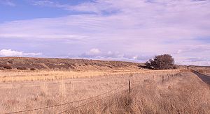
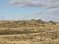
Sims Corner Eskers and Kames
Encyclopedia
National Natural Landmark
The National Natural Landmark program recognizes and encourages the conservation of outstanding examples of the natural history of the United States. It is the only natural areas program of national scope that identifies and recognizes the best examples of biological and geological features in...
includes excellent examples of Pleistocene ice stagnation landforms including numerous glacial erratic
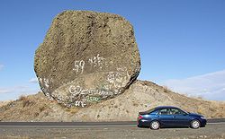
Glacial erratic
A glacial erratic is a piece of rock that differs from the size and type of rock native to the area in which it rests. "Erratics" take their name from the Latin word errare, and are carried by glacial ice, often over distances of hundreds of kilometres...
s, terminal moraine
Moraine
A moraine is any glacially formed accumulation of unconsolidated glacial debris which can occur in currently glaciated and formerly glaciated regions, such as those areas acted upon by a past glacial maximum. This debris may have been plucked off a valley floor as a glacier advanced or it may have...
s, esker
Esker
An esker is a long winding ridge of stratified sand and gravel, examples of which occur in glaciated and formerly glaciated regions of Europe and North America...
s, and kame
Kame
A kame is a geological feature, an irregularly shaped hill or mound composed of sand, gravel and till that accumulates in a depression on a retreating glacier, and is then deposited on the land surface with further melting of the glacier...
s. It is located on the Waterville Plateau of the Columbia Plateau in north central Washington state in the United States.
(Coordinates: 47°49′30"N 119°22′00"W)
Geologic History
The plateau
The Sims Corner Eskers and Kames National Natural Landmark is located on the Waterville Plateau, which lies in the northwest corner of the Columbia River PlateauColumbia River Plateau
The Columbia Plateau is a geologic and geographic region that lies across parts of the U.S. states of Washington, Oregon, and Idaho. It is a wide flood basalt plateau between the Cascade Range and the Rocky Mountains, cut through by the Columbia River...
. The plateau is formed on top of the Columbia River Basalt Group
Columbia River Basalt Group
The Columbia River Basalt Group is a large igneous province that lies across parts of the Western United States. It is found in the U.S. states of Washington, Oregon, Idaho, Nevada, and California...
a large igneous province
Large igneous province
A Large Igneous Province is an extremely large accumulation of igneous rocks—intrusive, extrusive, or both—in the earth's crust...
that lies across parts of the states of Washington, Oregon
Oregon
Oregon is a state in the Pacific Northwest region of the United States. It is located on the Pacific coast, with Washington to the north, California to the south, Nevada on the southeast and Idaho to the east. The Columbia and Snake rivers delineate much of Oregon's northern and eastern...
, and Idaho
Idaho
Idaho is a state in the Rocky Mountain area of the United States. The state's largest city and capital is Boise. Residents are called "Idahoans". Idaho was admitted to the Union on July 3, 1890, as the 43rd state....
in the United States of America. During late Miocene
Miocene
The Miocene is a geological epoch of the Neogene Period and extends from about . The Miocene was named by Sir Charles Lyell. Its name comes from the Greek words and and means "less recent" because it has 18% fewer modern sea invertebrates than the Pliocene. The Miocene follows the Oligocene...
and early Pliocene
Pliocene
The Pliocene Epoch is the period in the geologic timescale that extends from 5.332 million to 2.588 million years before present. It is the second and youngest epoch of the Neogene Period in the Cenozoic Era. The Pliocene follows the Miocene Epoch and is followed by the Pleistocene Epoch...
times, one of the largest flood basalt
Flood basalt
A flood basalt or trap basalt is the result of a giant volcanic eruption or series of eruptions that coats large stretches of land or the ocean floor with basalt lava. Flood basalts have occurred on continental scales in prehistory, creating great plateaus and mountain ranges...
s ever to appear on the earth
Earth
Earth is the third planet from the Sun, and the densest and fifth-largest of the eight planets in the Solar System. It is also the largest of the Solar System's four terrestrial planets...
's surface engulfed about 163,700 km² (63,000 mile²) of the Pacific Northwest, forming a large igneous province
Large igneous province
A Large Igneous Province is an extremely large accumulation of igneous rocks—intrusive, extrusive, or both—in the earth's crust...
with an estimated volume of 174,300 km3. Eruptions were most vigorous from 17—14 million years ago, when over 99% of the basalt was released. Less extensive eruptions continued from 14—6 million years ago.
These lava flows have been extensively exposed by the erosion resulting from the Missoula Floods
Missoula Floods
The Missoula Floods refer to the cataclysmic floods that swept periodically across eastern Washington and down the Columbia River Gorge at the end of the last ice age. The glacial flood events have been researched since the 1920s...
, which laid bare many layers of the basalt flows on the edges of the plateau at Grand Coulee
Grand Coulee
The Grand Coulee is an ancient river bed in the U.S. state of Washington. This National Natural Landmark stretches for about sixty miles southwest from Grand Coulee Dam to Soap Lake, being bisected by Dry Falls into the Upper and Lower Grand Coulee....
and Moses Coulee
Moses Coulee
Moses Coulee cuts into the Waterville plateau in Douglas County, Washington. It is to the west of and roughly parallel to the more famous Grand Coulee...
.
The glacial history
Pleistocene
The Pleistocene is the epoch from 2,588,000 to 11,700 years BP that spans the world's recent period of repeated glaciations. The name pleistocene is derived from the Greek and ....
epoch began and Ice age
Ice age
An ice age or, more precisely, glacial age, is a generic geological period of long-term reduction in the temperature of the Earth's surface and atmosphere, resulting in the presence or expansion of continental ice sheets, polar ice sheets and alpine glaciers...
glaciers invaded the area. They scoured the Columbia River Plateau, reaching as far south as the middle of the Waterville Plateau highlands above the Grand Coulee and south to the head of Moses Coulee
Moses Coulee
Moses Coulee cuts into the Waterville plateau in Douglas County, Washington. It is to the west of and roughly parallel to the more famous Grand Coulee...
. In some areas north of the Grand Coulee they were as much as 3 km (10000 feet) thick. Grooves in the exposed granite bedrock are still visible in the area from the movement of glaciers and numerous glacial erratic
Glacial erratic
A glacial erratic is a piece of rock that differs from the size and type of rock native to the area in which it rests. "Erratics" take their name from the Latin word errare, and are carried by glacial ice, often over distances of hundreds of kilometres...
s in the elevated to the Northwest of the coulee.
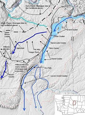
Creation of the Foster Coulee, Moses Coulee and Grand Coulee
Cordilleran Ice Sheet
The Cordilleran ice sheet was a major ice sheet that covered, during glacial periods of the Quaternary, a large area of North America. This included the following areas:*Western Montana*The Idaho Panhandle...
moved down the Okanogan River
Okanogan River
The Okanogan River is a tributary of the Columbia River, approximately 115 mi long, in southern British Columbia and north central Washington...
valley and blocked the ancient route of the Columbia River, backing up water to create Lake Spokane. Initially water discharged from Lake Spokane by running up through the head of Grand Coulee and down through Foster Coulee to rejoin the Columbia River. As the glacier moved further south, Foster Coulee was cut off and the Columbia River then discharged through Moses Coulee
Moses Coulee
Moses Coulee cuts into the Waterville plateau in Douglas County, Washington. It is to the west of and roughly parallel to the more famous Grand Coulee...
, which runs southward slightly to the east of the ancient and current course of the Columbia. As the Okanogan lobe grew, it blocked Moses Coulee as well; the Columbia found the next lowest route through the region which was eroded to become the modern Grand Coulee
Grand Coulee
The Grand Coulee is an ancient river bed in the U.S. state of Washington. This National Natural Landmark stretches for about sixty miles southwest from Grand Coulee Dam to Soap Lake, being bisected by Dry Falls into the Upper and Lower Grand Coulee....
. Flowing across the current Grand Coulee & Dry Falls regions, the ice age Columbia then entered the Quincy Basin & joined Crab Creek, following Crab Creek’s course southward past the Frenchman Hills and turning west to run along the north face of the Saddle Mountains
Saddle Mountains
The Saddle Mountains consists of an upfolded anticline ridge of basalt in Grant County of central Washington state. The ridge, reaching to 2,700 feet, terminates in the east south of Othello, Washington near the foot of the Drumheller Channels...
& rejoin the previous and modern course of the Columbia River just above the main water gap in the Saddle Mountains, Sentinel Gap.