
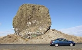
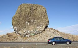
Boulder Park
Encyclopedia
National Natural Landmark
The National Natural Landmark program recognizes and encourages the conservation of outstanding examples of the natural history of the United States. It is the only natural areas program of national scope that identifies and recognizes the best examples of biological and geological features in...
, along with the nearby Natural Landmarks McNeil Canyon Haystack Rocks and Sims Corner Eskers and Kames
Sims Corner Eskers and Kames
The Sims Corner Eskers and Kames National Natural Landmark includes excellent examples of Pleistocene ice stagnation landforms including numerous glacial erratics, terminal moraines, eskers, and kames...
comprise several of the best examples of Pleistocene
Pleistocene
The Pleistocene is the epoch from 2,588,000 to 11,700 years BP that spans the world's recent period of repeated glaciations. The name pleistocene is derived from the Greek and ....
ice stagnation landforms in Washington. Feature include numerous glacial erratic
Glacial erratic
A glacial erratic is a piece of rock that differs from the size and type of rock native to the area in which it rests. "Erratics" take their name from the Latin word errare, and are carried by glacial ice, often over distances of hundreds of kilometres...
s near and on the terminal moraine
Moraine
A moraine is any glacially formed accumulation of unconsolidated glacial debris which can occur in currently glaciated and formerly glaciated regions, such as those areas acted upon by a past glacial maximum. This debris may have been plucked off a valley floor as a glacier advanced or it may have...
. Boulder Park is located on the Waterville Plateau of the Columbia Plateau
Columbia Plateau
The Columbia Plateau is a geologic and geographic region that lies across parts of the U.S. states of Washington, Oregon, and Idaho. It is a wide flood basalt plateau between the Cascade Range and the Rocky Mountains, cut through by the Columbia River...
in north central Washington state in the United States. The boulders provide important evidence for glacial erosion and transport, as well as marking the direction of movement and the terminus of the Okanogan lobe on the southern margin of the Cordilleran ice sheet
Cordilleran Ice Sheet
The Cordilleran ice sheet was a major ice sheet that covered, during glacial periods of the Quaternary, a large area of North America. This included the following areas:*Western Montana*The Idaho Panhandle...
during the last glaciation.
See also
- List of National Natural Landmarks in Washington State