

Grand Coulee
Encyclopedia
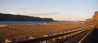
The Grand Coulee is an ancient river bed in the U.S. state of Washington. This National Natural Landmark
National Natural Landmark
The National Natural Landmark program recognizes and encourages the conservation of outstanding examples of the natural history of the United States. It is the only natural areas program of national scope that identifies and recognizes the best examples of biological and geological features in...
stretches for about sixty miles southwest from Grand Coulee Dam
Grand Coulee Dam
Grand Coulee Dam is a gravity dam on the Columbia River in the U.S. state of Washington built to produce hydroelectric power and provide irrigation. It was constructed between 1933 and 1942, originally with two power plants. A third power station was completed in 1974 to increase its energy...
to Soap Lake
Soap Lake
Soap Lake is a meromictic lake in the town of Soap Lake, Washington formed by the Missoula Floods at the foot of the Grand Coulee. The lake gets its name from the naturally occurring foam that gives its water a soapy appearance and because the lake's mineral-rich waters have a slick, soapy feel...
, being bisected by Dry Falls
Dry Falls
Dry Falls is a 3.5 mile long scalloped precipice in central Washington, on the opposite side of the Upper Grand Coulee from the Columbia River, and at the head of the Lower Grand Coulee. Ten times the size of Niagara, Dry Falls is thought to be the greatest known waterfall that ever existed...
into the Upper and Lower Grand Coulee
Coulee
Coulee is applied rather loosely to different landforms, all of which refer to a kind of valley or drainage zone.The word coulee comes from the Canadian French coulée, from French word couler meaning "to flow"....
.
Geological history

Columbia River Plateau
The Columbia Plateau is a geologic and geographic region that lies across parts of the U.S. states of Washington, Oregon, and Idaho. It is a wide flood basalt plateau between the Cascade Range and the Rocky Mountains, cut through by the Columbia River...
. This area has underlying granite
Granite
Granite is a common and widely occurring type of intrusive, felsic, igneous rock. Granite usually has a medium- to coarse-grained texture. Occasionally some individual crystals are larger than the groundmass, in which case the texture is known as porphyritic. A granitic rock with a porphyritic...
bedrock, formed deep in the Earth's crust 40 to 60 Ma (million years ago). The land periodically uplifted and subsided over millions of years giving rise to some small mountains and, eventually, an inland sea.
From about 10 to 18 Million years ago, a series of volcanic eruptions from the Grand Ronde Rift, near the Idaho/Oregon/Washington border began to fill the inland sea with lava. In some places the volcanic basalt
Basalt
Basalt is a common extrusive volcanic rock. It is usually grey to black and fine-grained due to rapid cooling of lava at the surface of a planet. It may be porphyritic containing larger crystals in a fine matrix, or vesicular, or frothy scoria. Unweathered basalt is black or grey...
is 2000 metres (6,561.7 ft) thick. In other areas granite from the earlier mountains is still exposed. Many animals roamed the area including camel, horse and rhinosaurus.
Two million years ago the Pleistocene
Pleistocene
The Pleistocene is the epoch from 2,588,000 to 11,700 years BP that spans the world's recent period of repeated glaciations. The name pleistocene is derived from the Greek and ....
epoch and glaciation
Glacial period
A glacial period is an interval of time within an ice age that is marked by colder temperatures and glacier advances. Interglacials, on the other hand, are periods of warmer climate within an ice age...
. Large parts of northern North America were repeatedly covered with glacial ice sheets, at times reaching over 10,000 fet in thickness. Periodic climate changes resulted in corresponding advances and retreats of ice.
About 18,000 years ago a large finger of ice advanced into present-day Idaho, forming an ice dam at what is now Lake Pend Oreille. It blocked the Clark Fork River drainage, thus creating an enormous lake reaching far back into mountain valleys of western Montana. As the lake deepened, the ice began to float. Leaks likely developed and enlarged, causing the dam to fail. Suddenly 500 cubic miles of Lake Missoula, 10 times the combined flow of all the rivers in the world, were released in 48 hours.
This mass of water and ice, towering 2000 feet (609.6 m) thick near the ice dam before release, flowed across the Columbia Basin, moving at speeds of up to 65 miles per hour. The deluge stripped away soil, cut deep canyons and carved out 50 cubic miles (208.4 km³) of earth, leaving behind areas of stark scabland.
Over nearly 2500 years the cycle was repeated many times. Most of the displaced soil created new landforms, but some was carried far out into the Pacific Ocean. In Oregon's Willamette Valley, as far south as Eugene, the cataclysmic flood waters deposited fertile soil and icebergs left numerous boulders from as far away as Montana and Canada. At present day Portland, the water measured 400 feet (121.9 m) deep. A canyon 200 feet (61 m) deep is carved into the far edge of the continental shelf. The web-like formation can be seen from space. Mountains of gravel as tall as 40-story buildings were left behind; boulders the size of small houses and weighing many tons were strewn about the landscape.
Grooves in the exposed granite bedrock are still visible in the area from the movement of glaciers, and numerous erratic
Glacial erratic
A glacial erratic is a piece of rock that differs from the size and type of rock native to the area in which it rests. "Erratics" take their name from the Latin word errare, and are carried by glacial ice, often over distances of hundreds of kilometres...
s are found in the elevated areas to the northwest of the coulee.
Early theories suggested that glaciers diverted the Columbia River
Columbia River
The Columbia River is the largest river in the Pacific Northwest region of North America. The river rises in the Rocky Mountains of British Columbia, Canada, flows northwest and then south into the U.S. state of Washington, then turns west to form most of the border between Washington and the state...
into what became the Grand Coulee and that normal flows caused the erosion observed. In 1910 Joseph T. Pardee described a great Ice Age lake, "Glacial Lake Missoula", a glacier dammed lake
Proglacial lake
In geology, a proglacial lake is a lake formed either by the damming action of a moraine or ice dam during the retreat of a melting glacier, or by meltwater trapped against an ice sheet due to isostatic depression of the crust around the ice...
with water up to 600 metres (1,968.5 ft) deep, in northwest Montana and in 1940 he reported his discovery that giant ripple marks 50 feet (15.2 m) high and 200-500 feet apart had formed the lake bed. In the 1920s J. Harlen Bretz looked deeper into the landscape and put forth his theory of the dam breaches and massive glacial floods from Lake Missoula.
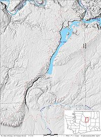
Of the Channeled Scablands
Channeled scablands
The Channeled Scablands are a unique geological erosion feature in the U.S. state of Washington. They were created by the cataclysmic Missoula Floods that swept periodically across eastern Washington and down the Columbia River Plateau during the Pleistocene epoch. Geologist J Harlen Bretz coined...
, Dry Falls
Dry Falls
Dry Falls is a 3.5 mile long scalloped precipice in central Washington, on the opposite side of the Upper Grand Coulee from the Columbia River, and at the head of the Lower Grand Coulee. Ten times the size of Niagara, Dry Falls is thought to be the greatest known waterfall that ever existed...
, one of the largest waterfalls ever known, is an excellent example (south of Banks Lake and visible in the image below).
It is probable that humans were witnesses, and victims, of the immense power of the Ice Age Floods. Archeological records date human presence back to nearly the end of the Ice Age, but the raging torrents erased the land of clear evidence, leaving us to question who, if anyone, may have survived. With the end of the last glacial advance, the Columbia settled into its present course. The river bed is about 200 metres (656.2 ft) below the Grand Coulee. Walls of the coulee reach 400 metres (1,312.3 ft) in height.
Modern Uses

Shrub-steppe
Shrub-steppe is a type of low rainfall natural grassland. Shrub-steppes are distinguishable from deserts, which are too dry to support a noticeable cover of perennial grasses or other shrubs, while the shrub-steppe has sufficient moisture levels to support a cover of perennial grasses and/or...
habitat, with an average annual rainfall of less than twelve inches (305 mm) . The Lower Grand Coulee contains Park, Blue, Alkali, Lenore, and Soap
Soap Lake
Soap Lake is a meromictic lake in the town of Soap Lake, Washington formed by the Missoula Floods at the foot of the Grand Coulee. The lake gets its name from the naturally occurring foam that gives its water a soapy appearance and because the lake's mineral-rich waters have a slick, soapy feel...
lakes. Until recently, the Upper Coulee was dry.
The Columbia Basin Project
Columbia Basin Project
The Columbia Basin Project in Central Washington, USA, is the irrigation network that the Grand Coulee Dam makes possible. It is the largest water reclamation project in the United States, supplying irrigation water to over of the large project area, all of which was originally intended to be...
changed this in 1952, using the ancient river bed as an irrigation distribution network. The Upper Grand Coulee was dammed and turned into Banks Lake
Banks Lake
Banks Lake is a long reservoir in central Washington in the United States.Part of the Columbia Basin Project, Banks Lake occupies the northern portion of the Grand Coulee, a formerly dry coulee near the Columbia River, formed by the Missoula Floods during the Pleistocene epoch. Grand Coulee Dam,...
. The lake is filled by pumps from the Grand Coulee Dam and forms the first leg of a hundred mile (160 km) irrigation system. Canals, siphons, and more dams are used throughout the Columbia Basin, supplying over 600,000 acres (2,400 km²) of farm land.
Water has turned the Upper Coulee and surrounding region into a haven for wildlife, including Bald Eagle
Bald Eagle
The Bald Eagle is a bird of prey found in North America. It is the national bird and symbol of the United States of America. This sea eagle has two known sub-species and forms a species pair with the White-tailed Eagle...
s. Recreation is a side benefit and includes several lakes, mineral springs, hunting and fishing, and water sports of all kinds. Sun Lakes
Sun Lakes State Park
Sun Lakes State Park is a camping park with of freshwater shoreline at the foot of Dry Falls, which is located near Coulee City, Washington. Formed by the Missoula Floods, Dry Falls is the site of a former waterfall which is now a stark cliff, high and wide. When the floods occurred, the...
and Steamboat Rock
Steamboat Rock State Park
Steamboat Rock State Park is a state park in the state of Washington in the United States. It is located near the north end of Banks Lake in the Grand Coulee. It covers , has of freshwater shoreline, and is open year-round for camping and day use...
state parks are both found in the Grand Coulee.
External links
- The Geologic Story of the Columbia Basin, BPA site
- 3D images of the Grand Coulee, USGS site
- WDFW - Wildlife of Eastside Shrubland and Grassland Habitats
- University of Washington Libraries Digital Collections – Lawrence Denny Lindsley Photographs Includes 146 images (ca. 1938 – 1958) of the Columbia River, Eastern Washington and the Grand Coulee region.
- JSTOR - Geographical Review