
Laigh Milton Viaduct
Encyclopedia
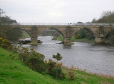
Laigh Milton Viaduct is a railway viaduct
near Laigh Milton mill at Gatehead in East Ayrshire
, Scotland
. It lies in the parishes of Kilmaurs and Dundonald, at map reference: NS 3834 3690. The viaduct was closed in 1846 when the railway line was realigned.
. It has four arches with sandstone ashlar
facings and rounded cutwaters: these were later extended to form semi-circular buttresses. The railway carried steam locomotives nine years before the Stockton and Darlington Railway
and is believed to be the first passenger steam railway in the world. The viaduct, built in 1811, is the oldest surviving railway viaduct in Scotland, and one of the oldest in the world: therefore having worldwide significance in industrial archaeology. The Causey Arch
built on the Tanfield Waggonway in County Durham in 1725 is claimed to be the oldest railway bridge in the World.
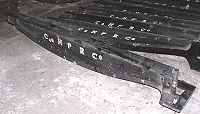
The Kilmarnock and Troon Railway was built by William Bentinck, Duke of Portland, to convey coal from pits to the west of Kilmarnock to Troon Harbour. It was the first line in Scotland to be authorised by an Act of Parliament and the first in Scotland on which a locomotive was used. The official opening took place on 6 July 1812. It was built using cast iron
plate rails with an inner flange.
There have been three bridges in this general area: furthest north or upstream from Laigh Milton mill the 1811 to 1846 bridge, the approaches to the 1846 to 1865 timber viaduct and furthest south, closer to Gatehead, the present railway viaduct.
s were probably erected within cofferdam
s as it is unlikely that any agreement could be reached to lower the water level by temporarily breaching the dam/weir
at Laigh Milton mill (NS33NE 51). The west pier is founded on a hard wood platform 5ins (127mm) thick at a depth about 6 ft (1.8 m) below normal river level, and rests on sand, gravel and weathered bedrock
. This timber is saturated but still hard. The poor quality local freestone has eroded more than a foot (0.3 m) at and near water level on all the piers, particularly at the west pier, but the foundation courses proved to be of hard stone in good condition. The internal pier hearting comprises thin flat stones bedded and set in lime mortar, and carried up to 5 ft (1.5 m) above the arch springings. This effective and traditional feature has probably saved the whole structure from collapse.
 The arch 'spandrel
s' are constructed from coursed rubble masonry; gravity-acting retaining walls each run the full length of the viaduct, and vary in width from 1 ft (0.3 m) at the top to 3 ft 6ins (1.1m) at a depth of 9 ft (2.7 m) by a series of internal steps. The distance between wall-faces is 12 ft (3.7 m) at depth, the steps being lined up by malleable iron pins, one of which was found in the top of the west arch. The walls simply rest upon the extrados of the undressed archstones without any lateral support apart from any buttressing effect from the bullnoses. The internal drainage comprises a pair of holes through the hearting of each pier down to or below water level. The cavity between the spandrel walls had been filled with stiff clay containing some gravel, probably contributing to the spandrel bulging.
The different masonry elements were not well tied together and some bulging has occurred, notably to the south spandrel wall. Up to several inches of masonry have been lost from much of the external facing, the builders having unwisely used minutely fissured local freestone.
 In 1807, William Bentinck, the Marquess of Titchfield (later the Duke of Portland) commissioned William Jessop
to survey the line. Jessop had already been involved with early railways, notably the Surrey Iron Railway. The contractor was John Simpson. Formerly coal had been taken by road to the harbour at Irvine
, some for export to Ireland (8000 tons in 1790). The line was authorised in 1808 and in 1809 the marquess became the 4th Duke of Portland, the largest landowner in Ayrshire
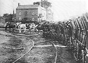
. In 1811 the 10 mile (9 miles and six furlongs) long line opened with two tracks of 4 ft gauge worked by horses, with frequent communications from one road to the other, so as to not only allow carriages or waggons to go both directions, but also to allow one carriage or waggon to pass another when both are travelling in the same direction. The 3 ft long flanged 'L' section rails, 4 inches in breadth, weighing 40 lbs each, were mounted with iron spikes driven into wooden oak plugs within stone blocks, 9 to 12 inches in thickness and rather more than a foot square at base and surface. 70,000 stone 'sleepers' were required at 6d. each, and a similar number of cast-iron rails, transported from Glenbuck
at an estimated £20,000. The wagons' wheels had no flanges. The ground on which the blocks and rails were laid was first beaten solid and then stones were beaten down. Where the line crossed Shewalton Moss, sand was first laid on the moss surface and then broom, whin, branches of trees or brushwood were laid over the sand. Two deep drains were cut either side of the rail-way. The tramway cost around £4,000 a mile to build.
 The gap between the rails was described as the 'horse path', filled high with road metal, and that between the two tracks as the 'attendants' path'. An ambiguous reference states that the distance between the rail roads or courses being the same as the width of each, a horse may travel in the middle space, with a wheel on the inner range of each of the roads. During restoration a layer of small broken stone was found at about the former track level, and presumably formed the 'attendants' path'. Three broken plate rails were also found at this level. Ordinary carts could use the route on payment of a toll, much like the Haytor Granite Tramway
and therefore strictly speaking the line was a tramway. Men were employed to sweep the rails clean of ballast kicked up by horses. The line was laid with a gentle 1 in 660 gradient, the total rise being 80 – 84 feet over the length of the entire line, equally divided over the whole course of the road. The horses could pull 160-220 cwts uphill and 200-240 cwts downhill. In 1839 130,500 tons were carried over the railway. There was a passenger service operated with at first just trucks filled with straw for passengers, but later two 'true' carriages, 'Caledonia' and 'The Boat', both built in Dundonald
, were purchased, with a through journey costing a shilling. Horses were changed at a stable at Gateside. In 1824, the salt pans on the Troon North Shore were acquired by Mr. Archibald Finnie, Kilmarnock, and he converted the buildings at the Pans into dwelling houses and stables for the men and horses employed on the rail-way (sic).
The Advertiser Times Herald of Troon advertised on 15 June 1812, The Caledonia, to carry passengers and goods from Kilmarnock to Troon upon the Iron Railway, will start on Saturday the 27th of June, from Gargieston, until the road is forwarded to Kilmarnock, and every Tuesday, Thursday and Saturday, afterwards at quarter past nine in the morning; and will leave Troon at six o’clock the same evening. Tickets of one shilling will be had of William Paterson, the proprietor – Croft; of Mr Begbie – Angel Inn, Kilmarnock; and of Mr S. Thomson, Troon. Proper attention will be made to passengers and goods The journey took something in the region of two hours.
In 1846 the Glasgow, Paisley, Kilmarnock and Ayr Railway
, which from 1843 connected with the line at both ends, leased and rebuilt the line with standard gauge
track capable of taking locomotives. It was purchased outright in 1899 by the Glasgow and South Western Railway
.
 John Ainslie's map of 1821 and John Thomson's map of 1828 both show the route of the Kilmarnock & Troon railway and the position of the ashlar
-built Laigh Milton viaduct crossing the River Irvine.
The first OS map of 1860 shows the viaduct as part of a track from West Gatehead farm across the Irvine to Cockhill farm and the Craig estate and its other mill, known as Girtrig Mill. A new wooden viaduct (opened in 1846) has replaced the Laigh Milton 'tramway' viaduct and the course of the railway has been altered, the highest point on the bank having been previously chosen (a fluvioglacial terrace), necessitating a pronounced curve in the line at this point. The new bridge required embankments on either side to give sufficient height over the river. On the 'Troon' side the site of the old track has been obliterated by Fairlie Colliery (Pit No.3) and its spoil bings, additionally a mineral line branches off at the Milton Ley
, runs at right angles to the viaduct and then across the path of the old track on the Gatehead side and runs up to the Thorntoun
and Gatehead collieries.
The 1898–1904 OS map shows a mineral line still running to Fairlie Colliery (Pit No.3), but the mineral lines to the Thorntoun and Gatehead collieries have been lifted. The position of the river crossing and a realignment of the route of the railway through Cockhill farm shows that the old wooden bridge has been abandoned and a new bridge built (opened in 1865) slightly further up river.
The 1911 OS map marks the trackbed alignment of the first and second bridges, whilst the 1860 mineral line to Thorntoun and Gatehead collieries is now shown as a footpath. Fairlie Colliery (Pit No.3) is still active with several sidings and spoil heaps. No track or lane is as yet shown running to West Gatehead farm.
McNaught's map of 1912 shows the colliery siding and indicates the access over the old viaduct to West Gatehead. It is likely that this access across Laigh Milton viaduct to the colliery allowed some coal to be taken off the site by road and allowed workers to get to and from the colliery.
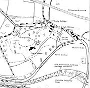 The 1921–28 OS map shows the area as Laigh Milton for the first time. The old ashlar viaduct is still clearly shown as part of the farm track to Cockhill farm from West Gatehead. No sign of the realignment of the railway or the old wooden viaduct are indicated and a saw mill is now marked, possibly the cause of the need for the extra definition of the name of the site.
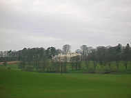
Cockhill and West Gatehead farms were probably part of the Pollok-Morris's Craig Estate in 1921–28, but Craig House was later sold to Glasgow Corporation as a 'respite home' for mainly Glaswegian children, and many of the farms sold off. Less access by farm traffic was therefore required across the old viaduct, which was past its centenary by this time, out of railway use, and presumably left to care for itself since abandonment. The result was that the viaduct ceased to be used by wheeled vehicles, allowing vegetation to take over, although the well-worn path present prior to the restoration showed that intrepid pedestrians still risked the crossing.
The 1985 1:25000 OS map shows the inter-farm route as still intact; the saw mill is not marked; and Laigh Milton mill has become a public house. The embankments of the old railway line that ran up to the old wooden viaduct are however shown here.
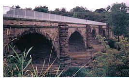 This 4-span viaduct was restored between 1992–96 at a cost of £1.065 million. The viaduct was investigated by radar scanning and apart from the structural repairs many years of invasive vegetation, including trees and shrubs, were removed.
Barr Construction, the main contractors, were awarded the Saltire Society's conservation award for the "skill in restoring a structure on the verge of collapse". There are of course no rails on this part of the line today, however a replica length of the original rails has been laid on the bridge itself. Access to the viaduct is by way of a muddy path alongside the River Irvine from near Laigh Milton Mill, where the old mill weir results in occasional flooding of the path.
's work with steam engines at Killingworth
in the north east of England, invited him to demonstrate one of his locomotives on the railway. In 1816/7 the locomotive, named The Duke, was set on the rails near Kilmarnock station, close to the now demolished Kilmarnock House, and was driven by Robert Stephenson
. Although the engine proved itself, it was too heavy (5 tons) for the cast-iron track. Wooden wheels were tried and were more successful. Sprocket-wheels on the driving axles also caused problems by digging up the pathway for horses which was raised up between the rails. An eye witness had commented upon the ease and grace by which the huge machine snorted along the line. On the day James and Robert Hood were "the first to fire the first iron horse, who eats coals instead of corn, in Scotland". The old coach-house of Kilmarnock House was turned into a coal store, being only four hundred yards from the tramway. The locomotive The Duke is also said to have later been sold on for £70. The modified Duke according to Mackintosh, retired in 1848, ended her days at Gargieston shed where she was eventually broken up for scrap.
 The Portland Bridge at Kings Mill Viaduct of 1817–19 is believed to be the oldest railway viaduct (as distinct from a single-span bridge) in England, and the fourth oldest railway bridge of any kind in the United Kingdom. The three known older examples are in County Durham (1727), Pitnall Tramway Bridge, Derbyshire (1802) and Laigh Milton Viaduct (1811). The engineer of the second and third of these was William Jessop
.
The Dick Institute holds a number of interesting artefacts, such as a map of the original proposed route of the railway, a model of The Duke, a painting of passenger and coal trains, details of the track in section, and so on.
The viaduct has gone by several alternative names, such as Gateside Viaduct, Drybridge Viaduct, West Gatehead Viaduct or even the 'wet bridge', as distinct from the nearby 'Drybridge'.
One story redolent of its era is that of a 'professional class' couple, Mr. & Mrs. Barker from England who committed suicide in Victorian times
(24 October 1844) by tying themselves together and jumping from Laigh Milton Viaduct into the Irvine, which has a depth of only around three feet at this point. They were buried in the Kilmaurs
-Glencairn churchyard in an unmarked grave. They are known to have spent a few weeks in lodgings and apparently enjoyed the 'sights and sounds' of Ayrshire. It transpired that they had recently become bankrupt and were fearful of the shame and disgrace that poverty would inevitably bring.
Gatehead railway station
was situated nearby, in the village of that name. It closed on 3 March 1969. Gatehead is likely to be named from the Turnpike
road and the tool bar. A 'Gatehead Toll Bar' is still marked on the road down to Laigh Milton mill and the Craig house estate on the 1860 OS map.
A hamlet called 'Milton' is marked on the 1821 and 1828 maps, but the name is not marked on the 1860 and the more recent OS maps.
The remains of the supports to the wooden viaduct at Laigh Milton can still be seen in the river Irvine when the water is exceptionally low.
The remains of the old Drybridge railway station
and the village of the same name are nearby. The name 'Drybridge' comes from the fact that most bridges up until the era of the railways were built over watercourses and were therefore 'wet bridges'. A 'Dry bridge' was such a novelty that the name has survived ever since. This part of the railway is still active as the part of the Glasgow South Western Line
(and officially known as the 'Burns Line') running from Kilmarnock
to Troon
.
The line closed to passengers in the late 1960s but today (2008) carries Stranraer
to Newcastle
and Glasgow to Girvan local passenger trains, although there are no stations open along its course. Coal trains also use this route.
was purchased in 1869 by the Glasgow and South Western Railway
Company. In 1881, an Act of Parliament
closed the canal. Much of the route was used to construct the Paisley Canal Line
. This line still uses the River Cart
Aqueduct (which it crosses at a skewed angle). This makes the former aqueduct the world's oldest railway bridge that is still in active use, having been built some time between 1807 and 1810.
Viaduct
A viaduct is a bridge composed of several small spans. The term viaduct is derived from the Latin via for road and ducere to lead something. However, the Ancient Romans did not use that term per se; it is a modern derivation from an analogy with aqueduct. Like the Roman aqueducts, many early...
near Laigh Milton mill at Gatehead in East Ayrshire
East Ayrshire
East Ayrshire is one of 32 council areas of Scotland. It borders on to North Ayrshire, East Renfrewshire, South Lanarkshire, South Ayrshire and Dumfries and Galloway...
, Scotland
Scotland
Scotland is a country that is part of the United Kingdom. Occupying the northern third of the island of Great Britain, it shares a border with England to the south and is bounded by the North Sea to the east, the Atlantic Ocean to the north and west, and the North Channel and Irish Sea to the...
. It lies in the parishes of Kilmaurs and Dundonald, at map reference: NS 3834 3690. The viaduct was closed in 1846 when the railway line was realigned.
Laigh Milton viaduct
The stone viaduct was part of the Kilmarnock and Troon RailwayKilmarnock and Troon Railway
The Kilmarnock and Troon Railway was the first railway line in Scotland authorised by Act of Parliament, in 1808; the engineer was William Jessop. It was the first railway in Scotland to use a steam locomotive; and it was the only one in Scotland for fourteen years...
. It has four arches with sandstone ashlar
Ashlar
Ashlar is prepared stone work of any type of stone. Masonry using such stones laid in parallel courses is known as ashlar masonry, whereas masonry using irregularly shaped stones is known as rubble masonry. Ashlar blocks are rectangular cuboid blocks that are masonry sculpted to have square edges...
facings and rounded cutwaters: these were later extended to form semi-circular buttresses. The railway carried steam locomotives nine years before the Stockton and Darlington Railway
Stockton and Darlington Railway
The Stockton and Darlington Railway , which opened in 1825, was the world's first publicly subscribed passenger railway. It was 26 miles long, and was built in north-eastern England between Witton Park and Stockton-on-Tees via Darlington, and connected to several collieries near Shildon...
and is believed to be the first passenger steam railway in the world. The viaduct, built in 1811, is the oldest surviving railway viaduct in Scotland, and one of the oldest in the world: therefore having worldwide significance in industrial archaeology. The Causey Arch
Causey Arch
The Causey Arch is a bridge near Stanley in County Durham. It is the world’s oldest surviving railway bridge.It was built in 1725-26 by stonemason Ralph Wood, funded by a conglomeration of coal-owners known as the "'Grand Allies'" at a cost of £12,000...
built on the Tanfield Waggonway in County Durham in 1725 is claimed to be the oldest railway bridge in the World.
The Kilmarnock and Troon Railway was built by William Bentinck, Duke of Portland, to convey coal from pits to the west of Kilmarnock to Troon Harbour. It was the first line in Scotland to be authorised by an Act of Parliament and the first in Scotland on which a locomotive was used. The official opening took place on 6 July 1812. It was built using cast iron
Cast iron
Cast iron is derived from pig iron, and while it usually refers to gray iron, it also identifies a large group of ferrous alloys which solidify with a eutectic. The color of a fractured surface can be used to identify an alloy. White cast iron is named after its white surface when fractured, due...
plate rails with an inner flange.
There have been three bridges in this general area: furthest north or upstream from Laigh Milton mill the 1811 to 1846 bridge, the approaches to the 1846 to 1865 timber viaduct and furthest south, closer to Gatehead, the present railway viaduct.
Statistics
The viaduct is about 270 ft (82.3 m) long by 19 ft (5.8 m) wide over all, and it carried the railway about 25 ft (7.6 m) above the river on four freestone arches of 40 ft (12.2 m) span with piers 9 ft (2.7 m) wide. Each arch is of segmental elevation with a rise of one third span and arch rings 2 ft (0.61 m) deep. No evidence of any former parapets has been found.Construction details
The pierPier
A pier is a raised structure, including bridge and building supports and walkways, over water, typically supported by widely spread piles or pillars...
s were probably erected within cofferdam
Cofferdam
A cofferdam is a temporary enclosure built within, or in pairs across, a body of water and constructed to allow the enclosed area to be pumped out, creating a dry work environment for the major work to proceed...
s as it is unlikely that any agreement could be reached to lower the water level by temporarily breaching the dam/weir
Weir
A weir is a small overflow dam used to alter the flow characteristics of a river or stream. In most cases weirs take the form of a barrier across the river that causes water to pool behind the structure , but allows water to flow over the top...
at Laigh Milton mill (NS33NE 51). The west pier is founded on a hard wood platform 5ins (127mm) thick at a depth about 6 ft (1.8 m) below normal river level, and rests on sand, gravel and weathered bedrock
Bedrock
In stratigraphy, bedrock is the native consolidated rock underlying the surface of a terrestrial planet, usually the Earth. Above the bedrock is usually an area of broken and weathered unconsolidated rock in the basal subsoil...
. This timber is saturated but still hard. The poor quality local freestone has eroded more than a foot (0.3 m) at and near water level on all the piers, particularly at the west pier, but the foundation courses proved to be of hard stone in good condition. The internal pier hearting comprises thin flat stones bedded and set in lime mortar, and carried up to 5 ft (1.5 m) above the arch springings. This effective and traditional feature has probably saved the whole structure from collapse.
Spandrel
A spandrel, less often spandril or splaundrel, is the space between two arches or between an arch and a rectangular enclosure....
s' are constructed from coursed rubble masonry; gravity-acting retaining walls each run the full length of the viaduct, and vary in width from 1 ft (0.3 m) at the top to 3 ft 6ins (1.1m) at a depth of 9 ft (2.7 m) by a series of internal steps. The distance between wall-faces is 12 ft (3.7 m) at depth, the steps being lined up by malleable iron pins, one of which was found in the top of the west arch. The walls simply rest upon the extrados of the undressed archstones without any lateral support apart from any buttressing effect from the bullnoses. The internal drainage comprises a pair of holes through the hearting of each pier down to or below water level. The cavity between the spandrel walls had been filled with stiff clay containing some gravel, probably contributing to the spandrel bulging.
The different masonry elements were not well tied together and some bulging has occurred, notably to the south spandrel wall. Up to several inches of masonry have been lost from much of the external facing, the builders having unwisely used minutely fissured local freestone.
Construction and operation of the Kilmarnock & Troon Railway
William Jessop
William Jessop was an English civil engineer, best known for his work on canals, harbours and early railways in the late 18th and early 19th centuries.-Early life:...
to survey the line. Jessop had already been involved with early railways, notably the Surrey Iron Railway. The contractor was John Simpson. Formerly coal had been taken by road to the harbour at Irvine
Irvine, North Ayrshire
Irvine is a new town on the coast of the Firth of Clyde in North Ayrshire, Scotland. According to 2007 population estimates, the town is home to 39,527 inhabitants, making it the biggest settlement in North Ayrshire....
, some for export to Ireland (8000 tons in 1790). The line was authorised in 1808 and in 1809 the marquess became the 4th Duke of Portland, the largest landowner in Ayrshire
Ayrshire
Ayrshire is a registration county, and former administrative county in south-west Scotland, United Kingdom, located on the shores of the Firth of Clyde. Its principal towns include Ayr, Kilmarnock and Irvine. The town of Troon on the coast has hosted the British Open Golf Championship twice in the...
. In 1811 the 10 mile (9 miles and six furlongs) long line opened with two tracks of 4 ft gauge worked by horses, with frequent communications from one road to the other, so as to not only allow carriages or waggons to go both directions, but also to allow one carriage or waggon to pass another when both are travelling in the same direction. The 3 ft long flanged 'L' section rails, 4 inches in breadth, weighing 40 lbs each, were mounted with iron spikes driven into wooden oak plugs within stone blocks, 9 to 12 inches in thickness and rather more than a foot square at base and surface. 70,000 stone 'sleepers' were required at 6d. each, and a similar number of cast-iron rails, transported from Glenbuck
Glenbuck
Glenbuck is a small, remote village in East Ayrshire. It nestles in the hills 3 miles east of Muirkirk, East Ayrshire, Scotland....
at an estimated £20,000. The wagons' wheels had no flanges. The ground on which the blocks and rails were laid was first beaten solid and then stones were beaten down. Where the line crossed Shewalton Moss, sand was first laid on the moss surface and then broom, whin, branches of trees or brushwood were laid over the sand. Two deep drains were cut either side of the rail-way. The tramway cost around £4,000 a mile to build.
Haytor Granite Tramway
The Haytor Granite Tramway was a unique granite-railed tramway running down from Haytor Down, Dartmoor, Devon. The tramway was built in 1820 to carry Haytor granite, which was of fine grain and high quality, down from the heights of Dartmoor for the construction of houses, bridges and other...
and therefore strictly speaking the line was a tramway. Men were employed to sweep the rails clean of ballast kicked up by horses. The line was laid with a gentle 1 in 660 gradient, the total rise being 80 – 84 feet over the length of the entire line, equally divided over the whole course of the road. The horses could pull 160-220 cwts uphill and 200-240 cwts downhill. In 1839 130,500 tons were carried over the railway. There was a passenger service operated with at first just trucks filled with straw for passengers, but later two 'true' carriages, 'Caledonia' and 'The Boat', both built in Dundonald
Dundonald
Dundonald is a large settlement in County Down, Northern Ireland. It lies east of Belfast and is often deemed to be a suburb of the city. It includes the large housing estate of Ballybeen, and many new housing estates have emerged in the past ten years....
, were purchased, with a through journey costing a shilling. Horses were changed at a stable at Gateside. In 1824, the salt pans on the Troon North Shore were acquired by Mr. Archibald Finnie, Kilmarnock, and he converted the buildings at the Pans into dwelling houses and stables for the men and horses employed on the rail-way (sic).
The Advertiser Times Herald of Troon advertised on 15 June 1812, The Caledonia, to carry passengers and goods from Kilmarnock to Troon upon the Iron Railway, will start on Saturday the 27th of June, from Gargieston, until the road is forwarded to Kilmarnock, and every Tuesday, Thursday and Saturday, afterwards at quarter past nine in the morning; and will leave Troon at six o’clock the same evening. Tickets of one shilling will be had of William Paterson, the proprietor – Croft; of Mr Begbie – Angel Inn, Kilmarnock; and of Mr S. Thomson, Troon. Proper attention will be made to passengers and goods The journey took something in the region of two hours.
In 1846 the Glasgow, Paisley, Kilmarnock and Ayr Railway
Glasgow, Paisley, Kilmarnock and Ayr Railway
The Glasgow, Paisley, Kilmarnock and Ayr Railway was a railway in Scotland that provided train services between Glasgow, Kilmarnock and Ayr. For a short period, it also provided West Coast services between Glasgow and London. Opened in stages between 1839 and 1848, the line ran from Paisley in the...
, which from 1843 connected with the line at both ends, leased and rebuilt the line with standard gauge
Standard gauge
The standard gauge is a widely-used track gauge . Approximately 60% of the world's existing railway lines are built to this gauge...
track capable of taking locomotives. It was purchased outright in 1899 by the Glasgow and South Western Railway
Glasgow and South Western Railway
The Glasgow and South Western Railway , one of the pre-grouping railway companies, served a triangular area of south-west Scotland, between Glasgow, Stranraer and Carlisle...
.
Evidence from Ordnance Survey (OS) and other maps
Ashlar
Ashlar is prepared stone work of any type of stone. Masonry using such stones laid in parallel courses is known as ashlar masonry, whereas masonry using irregularly shaped stones is known as rubble masonry. Ashlar blocks are rectangular cuboid blocks that are masonry sculpted to have square edges...
-built Laigh Milton viaduct crossing the River Irvine.
The first OS map of 1860 shows the viaduct as part of a track from West Gatehead farm across the Irvine to Cockhill farm and the Craig estate and its other mill, known as Girtrig Mill. A new wooden viaduct (opened in 1846) has replaced the Laigh Milton 'tramway' viaduct and the course of the railway has been altered, the highest point on the bank having been previously chosen (a fluvioglacial terrace), necessitating a pronounced curve in the line at this point. The new bridge required embankments on either side to give sufficient height over the river. On the 'Troon' side the site of the old track has been obliterated by Fairlie Colliery (Pit No.3) and its spoil bings, additionally a mineral line branches off at the Milton Ley
LEY
LEY may refer to:* Lelystad Airport, The Netherlands; IATA airport code: LEY* Leyland railway station, England; National Rail station code: LEY...
, runs at right angles to the viaduct and then across the path of the old track on the Gatehead side and runs up to the Thorntoun
Thorntoun house and estate
Thorntoun School was opened by Barnardo's in September 1971 for children with emotional difficulties aged 11 to 16 years. The school closed in 1990 and Thorntoun is now a Nursing Home. The complex lies between the villages of Springside and Crosshouse, Kilmarnock in East Ayrshire, Scotland...
and Gatehead collieries.
| Etymology |
| 'Laigh' is the Scots for 'Low'. A 'Toun' or 'Ton' was a farm and its outbuildings, associated here with the Mill as millers often farmed on a small scale. |
The 1898–1904 OS map shows a mineral line still running to Fairlie Colliery (Pit No.3), but the mineral lines to the Thorntoun and Gatehead collieries have been lifted. The position of the river crossing and a realignment of the route of the railway through Cockhill farm shows that the old wooden bridge has been abandoned and a new bridge built (opened in 1865) slightly further up river.
The 1911 OS map marks the trackbed alignment of the first and second bridges, whilst the 1860 mineral line to Thorntoun and Gatehead collieries is now shown as a footpath. Fairlie Colliery (Pit No.3) is still active with several sidings and spoil heaps. No track or lane is as yet shown running to West Gatehead farm.
McNaught's map of 1912 shows the colliery siding and indicates the access over the old viaduct to West Gatehead. It is likely that this access across Laigh Milton viaduct to the colliery allowed some coal to be taken off the site by road and allowed workers to get to and from the colliery.
Cockhill and West Gatehead farms were probably part of the Pollok-Morris's Craig Estate in 1921–28, but Craig House was later sold to Glasgow Corporation as a 'respite home' for mainly Glaswegian children, and many of the farms sold off. Less access by farm traffic was therefore required across the old viaduct, which was past its centenary by this time, out of railway use, and presumably left to care for itself since abandonment. The result was that the viaduct ceased to be used by wheeled vehicles, allowing vegetation to take over, although the well-worn path present prior to the restoration showed that intrepid pedestrians still risked the crossing.
The 1985 1:25000 OS map shows the inter-farm route as still intact; the saw mill is not marked; and Laigh Milton mill has become a public house. The embankments of the old railway line that ran up to the old wooden viaduct are however shown here.
Restoration
Barr Construction, the main contractors, were awarded the Saltire Society's conservation award for the "skill in restoring a structure on the verge of collapse". There are of course no rails on this part of the line today, however a replica length of the original rails has been laid on the bridge itself. Access to the viaduct is by way of a muddy path alongside the River Irvine from near Laigh Milton Mill, where the old mill weir results in occasional flooding of the path.
Traditions and micro history
The Duke of Portland, hearing of George StephensonGeorge Stephenson
George Stephenson was an English civil engineer and mechanical engineer who built the first public railway line in the world to use steam locomotives...
's work with steam engines at Killingworth
Killingworth
Killingworth, formerly Killingworth Township, is a town north of Newcastle Upon Tyne, in North Tyneside, United Kingdom.Built as a planned town in the 1960s, most of Killingworth's residents commute to Newcastle, or the city's surrounding area. However, Killingworth itself has a sizeable...
in the north east of England, invited him to demonstrate one of his locomotives on the railway. In 1816/7 the locomotive, named The Duke, was set on the rails near Kilmarnock station, close to the now demolished Kilmarnock House, and was driven by Robert Stephenson
Robert Stephenson
Robert Stephenson FRS was an English civil engineer. He was the only son of George Stephenson, the famed locomotive builder and railway engineer; many of the achievements popularly credited to his father were actually the joint efforts of father and son.-Early life :He was born on the 16th of...
. Although the engine proved itself, it was too heavy (5 tons) for the cast-iron track. Wooden wheels were tried and were more successful. Sprocket-wheels on the driving axles also caused problems by digging up the pathway for horses which was raised up between the rails. An eye witness had commented upon the ease and grace by which the huge machine snorted along the line. On the day James and Robert Hood were "the first to fire the first iron horse, who eats coals instead of corn, in Scotland". The old coach-house of Kilmarnock House was turned into a coal store, being only four hundred yards from the tramway. The locomotive The Duke is also said to have later been sold on for £70. The modified Duke according to Mackintosh, retired in 1848, ended her days at Gargieston shed where she was eventually broken up for scrap.
William Jessop
William Jessop was an English civil engineer, best known for his work on canals, harbours and early railways in the late 18th and early 19th centuries.-Early life:...
.
The Dick Institute holds a number of interesting artefacts, such as a map of the original proposed route of the railway, a model of The Duke, a painting of passenger and coal trains, details of the track in section, and so on.
The viaduct has gone by several alternative names, such as Gateside Viaduct, Drybridge Viaduct, West Gatehead Viaduct or even the 'wet bridge', as distinct from the nearby 'Drybridge'.
One story redolent of its era is that of a 'professional class' couple, Mr. & Mrs. Barker from England who committed suicide in Victorian times
Victorian era
The Victorian era of British history was the period of Queen Victoria's reign from 20 June 1837 until her death on 22 January 1901. It was a long period of peace, prosperity, refined sensibilities and national self-confidence...
(24 October 1844) by tying themselves together and jumping from Laigh Milton Viaduct into the Irvine, which has a depth of only around three feet at this point. They were buried in the Kilmaurs
Kilmaurs
Kilmaurs is a village in East Ayrshire, Scotland. It lies on the Carmel, 21.1 miles south by west of Glasgow. Population recorded in 2001 Census, 2601- History :...
-Glencairn churchyard in an unmarked grave. They are known to have spent a few weeks in lodgings and apparently enjoyed the 'sights and sounds' of Ayrshire. It transpired that they had recently become bankrupt and were fearful of the shame and disgrace that poverty would inevitably bring.
Gatehead railway station
Gatehead railway station
Gatehead railway station was a railway station serving the village of Gatehead, East Ayrshire, Scotland.- History :The station was opened on 6 July 1812 by the Kilmarnock and Troon Railway...
was situated nearby, in the village of that name. It closed on 3 March 1969. Gatehead is likely to be named from the Turnpike
Toll road
A toll road is a privately or publicly built road for which a driver pays a toll for use. Structures for which tolls are charged include toll bridges and toll tunnels. Non-toll roads are financed using other sources of revenue, most typically fuel tax or general tax funds...
road and the tool bar. A 'Gatehead Toll Bar' is still marked on the road down to Laigh Milton mill and the Craig house estate on the 1860 OS map.
A hamlet called 'Milton' is marked on the 1821 and 1828 maps, but the name is not marked on the 1860 and the more recent OS maps.
The remains of the supports to the wooden viaduct at Laigh Milton can still be seen in the river Irvine when the water is exceptionally low.
The remains of the old Drybridge railway station
Drybridge railway station
Drybridge railway station was a railway station serving the village of Drybridge, North Ayrshire, Scotland.-History:The station was opened on 6 July 1812 by the Kilmarnock and Troon Railway. The Glasgow, Paisley, Kilmarnock and Ayr Railway took over management of the station on 16 July 1846, while...
and the village of the same name are nearby. The name 'Drybridge' comes from the fact that most bridges up until the era of the railways were built over watercourses and were therefore 'wet bridges'. A 'Dry bridge' was such a novelty that the name has survived ever since. This part of the railway is still active as the part of the Glasgow South Western Line
Glasgow South Western Line
The Glasgow South Western Line is a mainline railway in Scotland that runs from Glasgow to Kilmarnock, and then either via Dumfries, or Stranraer via Ayr, with a branch to East Kilbride.- History :...
(and officially known as the 'Burns Line') running from Kilmarnock
Kilmarnock
Kilmarnock is a large burgh in East Ayrshire, Scotland, with a population of 44,734. It is the second largest town in Ayrshire. The River Irvine runs through its eastern section, and the Kilmarnock Water passes through it, giving rise to the name 'Bank Street'...
to Troon
Troon
Troon is a town in South Ayrshire. It is situated on the west coast of Scotland, about eight miles north of Ayr and three miles northwest of Glasgow Prestwick International Airport. Lying across the Firth of Clyde, the Isle of Arran can be seen. Troon is also a port with freight and ferry services...
.
The line closed to passengers in the late 1960s but today (2008) carries Stranraer
Stranraer
Stranraer is a town in the southwest of Scotland. It lies in the west of Dumfries and Galloway and in the county of Wigtownshire.Stranraer lies on the shores of Loch Ryan on the northern side of the isthmus joining the Rhins of Galloway to the mainland...
to Newcastle
Newcastle upon Tyne
Newcastle upon Tyne is a city and metropolitan borough of Tyne and Wear, in North East England. Historically a part of Northumberland, it is situated on the north bank of the River Tyne...
and Glasgow to Girvan local passenger trains, although there are no stations open along its course. Coal trains also use this route.
Other ancient Scottish railway viaducts
The Glasgow, Paisley and Johnstone CanalGlasgow, Paisley and Johnstone Canal
The Glasgow, Paisley and Ardrossan Canal was a canal in the west of Scotland, running between Glasgow, Paisley and Johnstone which later became a railway. Despite the name, the canal was never completed down to Ardrossan, the termini being Port Eglinton in Glasgow and Thorn Brae in Johnstone...
was purchased in 1869 by the Glasgow and South Western Railway
Glasgow and South Western Railway
The Glasgow and South Western Railway , one of the pre-grouping railway companies, served a triangular area of south-west Scotland, between Glasgow, Stranraer and Carlisle...
Company. In 1881, an Act of Parliament
Act of Parliament
An Act of Parliament is a statute enacted as primary legislation by a national or sub-national parliament. In the Republic of Ireland the term Act of the Oireachtas is used, and in the United States the term Act of Congress is used.In Commonwealth countries, the term is used both in a narrow...
closed the canal. Much of the route was used to construct the Paisley Canal Line
Paisley Canal Line
The Paisley Canal Railway line was originally a Glasgow and South Western Railway branch line running from Glasgow, Scotland, through three stations in Paisley, to North Johnstone...
. This line still uses the River Cart
River Cart
The River Cart is a tributary of the River Clyde, Scotland, which it joins from the west roughly midway between the towns of Erskine and Renfrew....
Aqueduct (which it crosses at a skewed angle). This makes the former aqueduct the world's oldest railway bridge that is still in active use, having been built some time between 1807 and 1810.
See also
- BridgeBridgeA bridge is a structure built to span physical obstacles such as a body of water, valley, or road, for the purpose of providing passage over the obstacle...
- Thorntoun house and estateThorntoun house and estateThorntoun School was opened by Barnardo's in September 1971 for children with emotional difficulties aged 11 to 16 years. The school closed in 1990 and Thorntoun is now a Nursing Home. The complex lies between the villages of Springside and Crosshouse, Kilmarnock in East Ayrshire, Scotland...
- A Researcher's Guide to Local History terminology
External links
- Ewan Crawford's history of the line
- A photograph and a map of the area
- Some details of the viaduct as a 'Railway' visitor attraction
- An older railway bridge in Wales
- Details of the restoration project
- The Saltire Award
- Maps at the National Library of Scotland
- 1860 OS Maps
- The Portland Bridge at Kings Mill
- The Dick Institute's collection of Kilmarnock & Troon Railway artifacts.