

Jo Daviess County, Illinois
Encyclopedia
Jo Daviess County is a county
located in the northwest corner of U.S. state
of Illinois
. According to the 2010 census, it has a population of 22,678, which is an increase of 1.7% from 22,289 in 2000. Its county seat
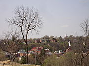
is Galena
.
As part of the Driftless Area, Jo Daviess County is known for its extraordinarily scenic stretches of road and valley views. Within Jo Daviess County lies Charles Mound
, the highest natural point in Illinois.
Jo Daviess County is part of the Tri-State Area and the Dubuque
, Iowa
, Galena
, Illinois
, Platteville
, Wisconsin
, metropolitan area. Jo Daviess County's population holds 13-15% of the area's population.
and Putnam Counties. It is named for Maj. Joseph Hamilton Daveiss, United States District Attorney for Kentucky
, who was killed in 1811 at the Battle of Tippecanoe
. Maj. Daveiss' name is universally misspelled, as in the name of this and other counties. The local pronunciation is "Davis".
A proposed wind farm would be located near the town of Nora
in the northeastern corner of the county.
As of the census
of 2000, there were 22,289 people, 9,218 households, and 6,286 families residing in the county. The population density
was 37 people per square mile (14/km²). There were 12,003 housing units at an average density of 20 per square mile (8/km²). The racial makeup of the county was 98.66% White
, 0.20% Black
or African American
, 0.10% Native American
, 0.16% Asian
, 0.34% from other races
, and 0.53% from two or more races. 1.53% of the population were Hispanic
or Latino
of any race. 46.9% were of German
, 11.5% Irish
, 10.5% American
and 9.0% English
ancestry according to Census 2000. 97.8% spoke English
and 1.7% Spanish
as their first language.
There were 9,218 households out of which 27.30% had children under the age of 18 living with them, 58.20% were married couples
living together, 6.50% had a female householder with no husband present, and 31.80% were non-families. 27.50% of all households were made up of individuals and 12.70% had someone living alone who was 65 years of age or older. The average household size was 2.40 and the average family size was 2.92.
In the county the population was spread out with 23.20% under the age of 18, 6.70% from 18 to 24, 25.30% from 25 to 44, 26.80% from 45 to 64, and 17.90% who were 65 years of age or older. The median age was 42 years. For every 100 females there were 100.50 males. For every 100 females age 18 and over, there were 97.00 males.
The median income for a household in the county was $40,411, and the median income for a family was $48,335. Males had a median income of $32,231 versus $22,096 for females. The per capita income
for the county was $21,497. About 4.00% of families and 6.70% of the population were below the poverty line, including 7.60% of those under age 18 and 7.50% of those age 65 or over.
:
County (United States)
In the United States, a county is a geographic subdivision of a state , usually assigned some governmental authority. The term "county" is used in 48 of the 50 states; Louisiana is divided into parishes and Alaska into boroughs. Parishes and boroughs are called "county-equivalents" by the U.S...
located in the northwest corner of U.S. state
U.S. state
A U.S. state is any one of the 50 federated states of the United States of America that share sovereignty with the federal government. Because of this shared sovereignty, an American is a citizen both of the federal entity and of his or her state of domicile. Four states use the official title of...
of Illinois
Illinois
Illinois is the fifth-most populous state of the United States of America, and is often noted for being a microcosm of the entire country. With Chicago in the northeast, small industrial cities and great agricultural productivity in central and northern Illinois, and natural resources like coal,...
. According to the 2010 census, it has a population of 22,678, which is an increase of 1.7% from 22,289 in 2000. Its county seat
County seat
A county seat is an administrative center, or seat of government, for a county or civil parish. The term is primarily used in the United States....
is Galena
Galena, Illinois
Galena is the county seat of, and largest city in, Jo Daviess County, Illinois in the United States, with a population of 3,429 in 2010. The city is a popular tourist destination known for its history, historical architecture, and ski and golf resorts. Galena was the residence of Ulysses S...
.
As part of the Driftless Area, Jo Daviess County is known for its extraordinarily scenic stretches of road and valley views. Within Jo Daviess County lies Charles Mound
Charles Mound
Charles Mound is a gentle, high hill in northern Jo Daviess County, Illinois, near the small town of Scales Mound and northeast of Galena. It is the highest natural point in the state; thus, it is considered a highpoint.- Geography :...
, the highest natural point in Illinois.
Jo Daviess County is part of the Tri-State Area and the Dubuque
Dubuque, Iowa
Dubuque is a city in and the county seat of Dubuque County, Iowa, United States, located along the Mississippi River. In 2010 its population was 57,637, making it the ninth-largest city in the state and the county's population was 93,653....
, Iowa
Iowa
Iowa is a state located in the Midwestern United States, an area often referred to as the "American Heartland". It derives its name from the Ioway people, one of the many American Indian tribes that occupied the state at the time of European exploration. Iowa was a part of the French colony of New...
, Galena
Galena, Illinois
Galena is the county seat of, and largest city in, Jo Daviess County, Illinois in the United States, with a population of 3,429 in 2010. The city is a popular tourist destination known for its history, historical architecture, and ski and golf resorts. Galena was the residence of Ulysses S...
, Illinois
Illinois
Illinois is the fifth-most populous state of the United States of America, and is often noted for being a microcosm of the entire country. With Chicago in the northeast, small industrial cities and great agricultural productivity in central and northern Illinois, and natural resources like coal,...
, Platteville
Platteville, Wisconsin
Platteville is the largest city in Grant County in southwestern Wisconsin. The population was 11,224 at the 2010 census, growing 12% since the 2000 Census. Much of this growth is likely due to the enrollment increase of the University of Wisconsin–Platteville...
, Wisconsin
Wisconsin
Wisconsin is a U.S. state located in the north-central United States and is part of the Midwest. It is bordered by Minnesota to the west, Iowa to the southwest, Illinois to the south, Lake Michigan to the east, Michigan to the northeast, and Lake Superior to the north. Wisconsin's capital is...
, metropolitan area. Jo Daviess County's population holds 13-15% of the area's population.
Geography
According to the 2010 census, the county has a total area of 618.73 square miles (1,602.5 km²), of which 601.09 square miles (1,556.8 km²) (or 97.15%) is land and 17.64 square miles (45.7 km²) (or 2.85%) is water.Major highways


Adjacent counties
- Lafayette CountyLafayette County, WisconsinLafayette County is a county located in the U.S. state of Wisconsin. As of 2000, the population was 16,137. Its county seat is Darlington.-Geography:According to the U.S...
, WisconsinWisconsinWisconsin is a U.S. state located in the north-central United States and is part of the Midwest. It is bordered by Minnesota to the west, Iowa to the southwest, Illinois to the south, Lake Michigan to the east, Michigan to the northeast, and Lake Superior to the north. Wisconsin's capital is...
- north - Stephenson CountyStephenson County, IllinoisAs of the census of 2000, there were 48,979 people, 19,785 households, and 13,473 families residing in the county. The population density was 87 people per square mile . There were 21,713 housing units at an average density of 38 per square mile...
- east - Carroll County - southeast
- Jackson CountyJackson County, Iowa-2010 census:The 2010 census recorded a population of 19,848 in the county, with a population density of . There were 9,415 housing units, of which 8,289 were occupied.-2000 census:...
, IowaIowaIowa is a state located in the Midwestern United States, an area often referred to as the "American Heartland". It derives its name from the Ioway people, one of the many American Indian tribes that occupied the state at the time of European exploration. Iowa was a part of the French colony of New...
- southwest (across the Mississippi River) - Dubuque CountyDubuque County, IowaDubuque County is a county located in the U.S. state of Iowa. The population was 93,653 in the 2010 census, an increase from 89,143 in the 2000 census. The county seat is the city of Dubuque. Dubuque County is coterminous with the Dubuque, Iowa Metropolitan Statistical Area, and is the seventh...
, IowaIowaIowa is a state located in the Midwestern United States, an area often referred to as the "American Heartland". It derives its name from the Ioway people, one of the many American Indian tribes that occupied the state at the time of European exploration. Iowa was a part of the French colony of New...
- west (across the Mississippi RiverMississippi RiverThe Mississippi River is the largest river system in North America. Flowing entirely in the United States, this river rises in western Minnesota and meanders slowly southwards for to the Mississippi River Delta at the Gulf of Mexico. With its many tributaries, the Mississippi's watershed drains...
) - Grant CountyGrant County, WisconsinGrant County is a county located in the U.S. state of Wisconsin. As of 2000, the population was 49,597. Its county seat is Lancaster. Estimates for 2008 show a population of 49,238...
, WisconsinWisconsinWisconsin is a U.S. state located in the north-central United States and is part of the Midwest. It is bordered by Minnesota to the west, Iowa to the southwest, Illinois to the south, Lake Michigan to the east, Michigan to the northeast, and Lake Superior to the north. Wisconsin's capital is...
- northwest
History
Jo Daviess County was formed in 1827 out of HenryHenry County, Illinois
Henry County is a county located in the U.S. state of Illinois. According to the 2010 census, it has a population of 50,486, which is a decrease of 1.0% from 51,020 in 2000. Its county seat is Cambridge...
and Putnam Counties. It is named for Maj. Joseph Hamilton Daveiss, United States District Attorney for Kentucky
Kentucky
The Commonwealth of Kentucky is a state located in the East Central United States of America. As classified by the United States Census Bureau, Kentucky is a Southern state, more specifically in the East South Central region. Kentucky is one of four U.S. states constituted as a commonwealth...
, who was killed in 1811 at the Battle of Tippecanoe
Battle of Tippecanoe
The Battle of Tippecanoe was fought on November 7, 1811, between United States forces led by Governor William Henry Harrison of the Indiana Territory and Native American warriors associated with the Shawnee leader Tecumseh. Tecumseh and his brother Tenskwatawa were leaders of a confederacy of...
. Maj. Daveiss' name is universally misspelled, as in the name of this and other counties. The local pronunciation is "Davis".
A proposed wind farm would be located near the town of Nora
Nora, Illinois
Nora is a village in Jo Daviess County, Illinois, United States. The population was 121 at the 2010 census, up from 118 at the 2000 census.-Geography:Nora is located at ....
in the northeastern corner of the county.
County border changes
- 1830- The northern border of Illinois and Wisconsin was formally established. Until that time, several Wisconsin towns actually were under the jurisdiction of Jo Daviess County.
- 1831- Rock Island CountyRock Island County, IllinoisRock Island County is a county located in the U.S. state of Illinois. According to the 2010 census, it has a population of 147,546, which is a decrease of 1.2% from 149,374 in 2000. Its county seat is Rock Island...
was formed from a part of the county, along with a new northern extension of Henry County and Putnam County. - 1836- Whiteside, OgleOgle County, IllinoisOgle County is a county located in the U.S. state of Illinois. According to the 2010 census, it has a population of 53,497, which is an increase of 4.8% from 51,032 in 2000. Its county seat is Oregon, and its largest city is Rochelle...
, and WinnebagoWinnebago County, IllinoisWinnebago County is a county located in the U.S. state of Illinois. According to the 2010 census, it has a population of 295,266, which is an increase of 6.1% from 278,418 in 2000...
counties were formed from the southern and eastern sections of the county. - 1837- Stephenson CountyStephenson County, IllinoisAs of the census of 2000, there were 48,979 people, 19,785 households, and 13,473 families residing in the county. The population density was 87 people per square mile . There were 21,713 housing units at an average density of 38 per square mile...
was formed from the eastern section of the county. - 1839- Carroll County was formed from the southern section of the county.
Population
As of the census
Census
A census is the procedure of systematically acquiring and recording information about the members of a given population. It is a regularly occurring and official count of a particular population. The term is used mostly in connection with national population and housing censuses; other common...
of 2000, there were 22,289 people, 9,218 households, and 6,286 families residing in the county. The population density
Population density
Population density is a measurement of population per unit area or unit volume. It is frequently applied to living organisms, and particularly to humans...
was 37 people per square mile (14/km²). There were 12,003 housing units at an average density of 20 per square mile (8/km²). The racial makeup of the county was 98.66% White
Race (United States Census)
Race and ethnicity in the United States Census, as defined by the Federal Office of Management and Budget and the United States Census Bureau, are self-identification data items in which residents choose the race or races with which they most closely identify, and indicate whether or not they are...
, 0.20% Black
Race (United States Census)
Race and ethnicity in the United States Census, as defined by the Federal Office of Management and Budget and the United States Census Bureau, are self-identification data items in which residents choose the race or races with which they most closely identify, and indicate whether or not they are...
or African American
Race (United States Census)
Race and ethnicity in the United States Census, as defined by the Federal Office of Management and Budget and the United States Census Bureau, are self-identification data items in which residents choose the race or races with which they most closely identify, and indicate whether or not they are...
, 0.10% Native American
Race (United States Census)
Race and ethnicity in the United States Census, as defined by the Federal Office of Management and Budget and the United States Census Bureau, are self-identification data items in which residents choose the race or races with which they most closely identify, and indicate whether or not they are...
, 0.16% Asian
Race (United States Census)
Race and ethnicity in the United States Census, as defined by the Federal Office of Management and Budget and the United States Census Bureau, are self-identification data items in which residents choose the race or races with which they most closely identify, and indicate whether or not they are...
, 0.34% from other races
Race (United States Census)
Race and ethnicity in the United States Census, as defined by the Federal Office of Management and Budget and the United States Census Bureau, are self-identification data items in which residents choose the race or races with which they most closely identify, and indicate whether or not they are...
, and 0.53% from two or more races. 1.53% of the population were Hispanic
Race (United States Census)
Race and ethnicity in the United States Census, as defined by the Federal Office of Management and Budget and the United States Census Bureau, are self-identification data items in which residents choose the race or races with which they most closely identify, and indicate whether or not they are...
or Latino
Race (United States Census)
Race and ethnicity in the United States Census, as defined by the Federal Office of Management and Budget and the United States Census Bureau, are self-identification data items in which residents choose the race or races with which they most closely identify, and indicate whether or not they are...
of any race. 46.9% were of German
Germans
The Germans are a Germanic ethnic group native to Central Europe. The English term Germans has referred to the German-speaking population of the Holy Roman Empire since the Late Middle Ages....
, 11.5% Irish
Irish people
The Irish people are an ethnic group who originate in Ireland, an island in northwestern Europe. Ireland has been populated for around 9,000 years , with the Irish people's earliest ancestors recorded having legends of being descended from groups such as the Nemedians, Fomorians, Fir Bolg, Tuatha...
, 10.5% American
United States
The United States of America is a federal constitutional republic comprising fifty states and a federal district...
and 9.0% English
English people
The English are a nation and ethnic group native to England, who speak English. The English identity is of early mediaeval origin, when they were known in Old English as the Anglecynn. England is now a country of the United Kingdom, and the majority of English people in England are British Citizens...
ancestry according to Census 2000. 97.8% spoke English
English language
English is a West Germanic language that arose in the Anglo-Saxon kingdoms of England and spread into what was to become south-east Scotland under the influence of the Anglian medieval kingdom of Northumbria...
and 1.7% Spanish
Spanish language
Spanish , also known as Castilian , is a Romance language in the Ibero-Romance group that evolved from several languages and dialects in central-northern Iberia around the 9th century and gradually spread with the expansion of the Kingdom of Castile into central and southern Iberia during the...
as their first language.
There were 9,218 households out of which 27.30% had children under the age of 18 living with them, 58.20% were married couples
Marriage
Marriage is a social union or legal contract between people that creates kinship. It is an institution in which interpersonal relationships, usually intimate and sexual, are acknowledged in a variety of ways, depending on the culture or subculture in which it is found...
living together, 6.50% had a female householder with no husband present, and 31.80% were non-families. 27.50% of all households were made up of individuals and 12.70% had someone living alone who was 65 years of age or older. The average household size was 2.40 and the average family size was 2.92.
In the county the population was spread out with 23.20% under the age of 18, 6.70% from 18 to 24, 25.30% from 25 to 44, 26.80% from 45 to 64, and 17.90% who were 65 years of age or older. The median age was 42 years. For every 100 females there were 100.50 males. For every 100 females age 18 and over, there were 97.00 males.
The median income for a household in the county was $40,411, and the median income for a family was $48,335. Males had a median income of $32,231 versus $22,096 for females. The per capita income
Per capita income
Per capita income or income per person is a measure of mean income within an economic aggregate, such as a country or city. It is calculated by taking a measure of all sources of income in the aggregate and dividing it by the total population...
for the county was $21,497. About 4.00% of families and 6.70% of the population were below the poverty line, including 7.60% of those under age 18 and 7.50% of those age 65 or over.
Cities and towns
- Apple RiverApple River, IllinoisApple River is a village in Jo Daviess County, Illinois, United States. The population was 366 at the 2010 census, down from 379 at the 2000 census.-Geography:Apple River is located at ....
- East DubuqueEast Dubuque, IllinoisEast Dubuque is a city in Jo Daviess County, Illinois, United States. The population was 1,704 at the 2010 census, down from 1,995 at the 2000 census. East Dubuque is located alongside the Mississippi River. Across the river is the city of Dubuque, Iowa. About three miles north of the city is the...
- ElizabethElizabeth, IllinoisElizabeth is a village in Jo Daviess County, Illinois, United States. The population was 761 at the 2010 census.-Geography:Elizabeth is located at ....
- GalenaGalena, IllinoisGalena is the county seat of, and largest city in, Jo Daviess County, Illinois in the United States, with a population of 3,429 in 2010. The city is a popular tourist destination known for its history, historical architecture, and ski and golf resorts. Galena was the residence of Ulysses S...
- HanoverHanover, IllinoisHanover is a village in Jo Daviess County, Illinois, along the Apple River. The population was 844 at the 2010 census, up from 836 at the 2000 census- Geography :Hanover is located at ....
- MenomineeMenominee, IllinoisMenominee is a village in Jo Daviess County, Illinois, United States. The population was 248 at the 2010 census, up from 237 at the 2000 census...
- NoraNora, IllinoisNora is a village in Jo Daviess County, Illinois, United States. The population was 121 at the 2010 census, up from 118 at the 2000 census.-Geography:Nora is located at ....
- Scales MoundScales Mound, IllinoisScales Mound is a village in Jo Daviess County, Illinois, United States. The population was 376 at the 2010 census, down from 401 at the 2000 census.-History:...
- StocktonStockton, IllinoisStockton is a village in Jo Daviess County, Illinois, United States. The population was 1,862 at the 2010 census, down from 1,926 at the 2000 census.-History:The village of Stockton is the youngest village in Jo Daviess County...
- WarrenWarren, IllinoisWarren is a village in Jo Daviess County, Illinois, United States. The population was 1,428 at the 2010 census, down from 1,496 at the 2000 census.Warren holds several festivals throughout the year...
Townships
Jo Daviess County is divided into twenty-three townshipsCivil township
A civil township is a widely used unit of local government in the United States, subordinate to, and geographic divisions of, a county. Specific responsibilities and the degree of autonomy vary based on each state. Civil townships are distinct from survey townships, but in states that have both,...
:
|
Hanover Township, Jo Daviess County, Illinois Hanover Township is one of twenty-three townships in Jo Daviess County, Illinois, USA. As of the 2000 census, its population was 1,229.-Geography:... Menominee Township, Jo Daviess County, Illinois Menominee Township is one of twenty-three townships in Jo Daviess County, Illinois, USA. As of the 2000 census, its population was 1,020.-Geography:... Nora Township, Jo Daviess County, Illinois Nora Township is one of twenty-three townships in Jo Daviess County, Illinois, USA. As of the 2000 census, its population was 404.-Geography:According to the United States Census Bureau, Nora Township covers an area of .-Adjacent townships:... Pleasant Valley Township, Jo Daviess County, Illinois Pleasant Valley Township is one of twenty-three townships in Jo Daviess County, Illinois, USA. As of the 2000 census, its population was 260.-Geography:According to the United States Census Bureau, Pleasant Valley Township covers an area of .... Rawlins Township, Jo Daviess County, Illinois Rawlins Township is one of twenty-three townships in Jo Daviess County, Illinois, USA. As of the 2000 census, its population was 360. It was formed as Grant Township from West Galena Township on July 12, 1887; its name changed to Rawlins Township on December 20, 1887.-Geography:According to the... Rice Township, Jo Daviess County, Illinois Rice Township is one of twenty-three townships in Jo Daviess County, Illinois, USA. As of the 2000 census, its population was 306. It was formed as Washington Township from East Galena Township on February 22, 1859; its name changed to Rice Township on June 16, 1859.-Geography:According to the... Rush Township, Jo Daviess County, Illinois Rush Township is one of twenty-three townships in Jo Daviess County, Illinois, USA. As of the 2000 census, its population was 427.-Geography:According to the United States Census Bureau, Rush Township covers an area of .-Adjacent townships:... Scales Mound Township, Jo Daviess County, Illinois Scales Mound Township is one of twenty-three townships in Jo Daviess County, Illinois, USA. As of the 2000 census, its population was 635. It was formed from Council Hill and Thompson townships on March 7, 1855.... |
Stockton Township, Jo Daviess County, Illinois Stockton Township is one of twenty-three townships in Jo Daviess County, Illinois, USA. As of the 2000 census, its population was 2,555.-Geography:According to the United States Census Bureau, Stockton Township covers an area of .-Adjacent townships:... Thompson Township, Jo Daviess County, Illinois Thompson Township is one of twenty-three townships in Jo Daviess County, Illinois, USA. As of the 2000 census, its population was 708.-Geography:... Vinegar Hill Township, Jo Daviess County, Illinois Vinegar Hill Township is one of twenty-three townships in Jo Daviess County, Illinois, USA. As of the 2000 census, its population was 250. Its name changed from Mann Township on September 18, 1857.-Geography:... Wards Grove Township, Jo Daviess County, Illinois Wards Grove Township is one of twenty-three townships in Jo Daviess County, Illinois, USA. As of the 2000 census, its population was 280.-Geography:According to the United States Census Bureau, Wards Grove Township covers an area of .-Adjacent townships:... Warren Township, Jo Daviess County, Illinois Warren Township is one of twenty-three townships in Jo Daviess County, Illinois, USA. As of the 2000 census, its population was 1,675. Its name changed from Courtland Township in 1865.-Geography:... West Galena Township, Jo Daviess County, Illinois West Galena Township is one of twenty-three townships in Jo Daviess County, Illinois, USA. As of the 2000 census, its population was 3,364.-Geography:... Woodbine Township, Jo Daviess County, Illinois Woodbine Township is one of twenty-three townships in Jo Daviess County, Illinois, USA. As of the 2000 census, its population was 577. Its name changed from Jefferson Township on September 13, 1853.-Geography:... |