
Jefferson County, Oregon
Encyclopedia
Jefferson County is a county located in the U.S. state
of Oregon
. In 2010, its population was 21,720. It is named
after Mount Jefferson
. The seat
of the county is Madras
.
. The county owes much of its agricultural prosperity to the railroad, which links Madras
with the Columbia River, and was completed in 1911, and to the development of irrigation projects in the late 1930s. The railroad was completed despite constant feuds and battles between two lines working on opposite sides of the Deschutes River.
Madras was incorporated in 1911, and has been the permanent county seat since a general election in 1916. The first (temporary) county seat was Culver, which was selected by a three man commission appointed by the governor. Due to repeated tie votes over several days (with one vote each cast for Culver, Metolius and Madras). The deadlock was eventually broken by allowing the Metolius Commissioner to post the tie-breaker, by voting for Culver. http://www.culver.k12.or.us/education/components/scrapbook/default.php?sectiondetailid=113&sc_id=1177344539&PHPSESSID=2c448115054eb2b061f906685b217908
Rapid development in adjacent Deschutes County, Oregon
during the 1990s has farmers in Jefferson County concerned that they may be priced out of their own farmlands, which could be replaced by destination resorts, golf courses, and other amenities for recent arrivals.
— partially located in the northwestern corner of the county — is the single biggest industry. With 300 days of sunshine and a low yearly rainfall, fishing, hunting, camping, boating, water-skiing and rock hunting are major tourist activities.
The major landowners in the county are the Forest Service
, which owns 24% of the lands within the county boundaries, and the Warm Springs Reservation, which owns 21%.
in Jefferson County, as well as most counties in eastern Oregon, are members of the Republican Party
. In the 2008 presidential election
, 51.47% of Jefferson County voters voted for Republican John McCain
, while 43.05% voted for Democrat
Barack Obama
and 5.46% of voters either voted for a Third Party
candidate or wrote in
a candidate. These numbers show a small shift towards the Democratic candidate as well as a Third Party candidate when compared to the 2004 presidential election
, in which 58.7% of Jefferson Country voters voted for George W. Bush
, while 40% voted for John Kerry
, and 1.3% of voters either voted for a Third Party candidate or wrote in a candidate
.
, the county has a total area of 1791 square miles (4,638.7 km²), of which 1781 square miles (4,612.8 km²) is land and 10 square miles (25.9 km²) (0.58%) is water.
As of the census
of 2000, there were 19,009 people, 6,727 households, and 5,166 families residing in the county. The population density
was 11 people per square mile (4/km²). There were 8,319 housing units at an average density of 5 per square mile (2/km²). The racial makeup of the county was 68.98% White
, 0.26% Black
or African American
, 15.68% Native American
, 0.30% Asian
, 0.22% Pacific Islander
, 11.32% from other races
, and 3.23% from two or more races. 17.74% of the population were Hispanic
or Latino
of any race. 13.6% were of German, 9.5% English
, 8.7% American
and 5.3% Irish
ancestry according to Census 2000. 82.2% spoke English
, 15.5% Spanish
and 1.0% Sahaptian
as their first language.
There were 6,727 households out of which 35.60% had children under the age of 18 living with them, 60.50% were married couples
living together, 10.50% had a female householder with no husband present, and 23.20% were non-families. 18.60% of all households were made up of individuals and 6.90% had someone living alone who was 65 years of age or older. The average household size was 2.80 and the average family size was 3.16.
In the county, the population was spread out with 29.80% under the age of 18, 7.70% from 18 to 24, 26.90% from 25 to 44, 23.20% from 45 to 64, and 12.40% who were 65 years of age or older. The median age was 35 years. For every 100 females there were 101.90 males. For every 100 females age 18 and over, there were 100.80 males.
The median income for a household in the county was $35,853, and the median income for a family was $39,151. Males had a median income of $31,126 versus $22,086 for females. The per capita income
for the county was $15,675. About 10.40% of families and 14.60% of the population were below the poverty line, including 22.20% of those under age 18 and 5.90% of those age 65 or over.
U.S. state
A U.S. state is any one of the 50 federated states of the United States of America that share sovereignty with the federal government. Because of this shared sovereignty, an American is a citizen both of the federal entity and of his or her state of domicile. Four states use the official title of...
of Oregon
Oregon
Oregon is a state in the Pacific Northwest region of the United States. It is located on the Pacific coast, with Washington to the north, California to the south, Nevada on the southeast and Idaho to the east. The Columbia and Snake rivers delineate much of Oregon's northern and eastern...
. In 2010, its population was 21,720. It is named
Oregon Geographic Names
Oregon Geographic Names is an authoritative compilation of the origin and meaning of place names in the U.S. state of Oregon. , the book is in its seventh edition and is compiled and edited by Lewis L. McArthur, who took over from his father, Lewis A. McArthur, as of the fourth edition...
after Mount Jefferson
Mount Jefferson (Oregon)
Mount Jefferson is a stratovolcano in the Cascade Volcanic Arc, part of the Cascade Range, and is the second highest mountain in Oregon. Situated in the far northeastern corner of Linn County on the Jefferson County line, about east of Corvallis, Mount Jefferson is in a rugged wilderness and is...
. The seat
County seat
A county seat is an administrative center, or seat of government, for a county or civil parish. The term is primarily used in the United States....
of the county is Madras
Madras, Oregon
Madras is a city in Jefferson County, Oregon, United States. Originally called The Basin after the circular valley the city is located in, it is unclear as to whether Madras was named in 1903 for the cotton fabric called "Madras" that originated in the Madras area in India, or from the city of...
.
History
Jefferson County was created on December 12, 1914, from a portion of Crook CountyCrook County, Oregon
-Demographics:As of the census of 2000, there were 19,182 people, 7,354 households, and 5,427 families residing in the county. The population density was 6 people per square mile . There were 8,264 housing units at an average density of 3 per square mile...
. The county owes much of its agricultural prosperity to the railroad, which links Madras
Madras, Oregon
Madras is a city in Jefferson County, Oregon, United States. Originally called The Basin after the circular valley the city is located in, it is unclear as to whether Madras was named in 1903 for the cotton fabric called "Madras" that originated in the Madras area in India, or from the city of...
with the Columbia River, and was completed in 1911, and to the development of irrigation projects in the late 1930s. The railroad was completed despite constant feuds and battles between two lines working on opposite sides of the Deschutes River.
Madras was incorporated in 1911, and has been the permanent county seat since a general election in 1916. The first (temporary) county seat was Culver, which was selected by a three man commission appointed by the governor. Due to repeated tie votes over several days (with one vote each cast for Culver, Metolius and Madras). The deadlock was eventually broken by allowing the Metolius Commissioner to post the tie-breaker, by voting for Culver. http://www.culver.k12.or.us/education/components/scrapbook/default.php?sectiondetailid=113&sc_id=1177344539&PHPSESSID=2c448115054eb2b061f906685b217908
Rapid development in adjacent Deschutes County, Oregon
Deschutes County, Oregon
-National protected areas:* Deschutes National Forest * Newberry National Volcanic Monument-Demographics:As of the census of 2000, there were 115,367 people, 45,595 households, and 31,962 families residing in the county. The population density was 38 people per square mile . There were 54,583...
during the 1990s has farmers in Jefferson County concerned that they may be priced out of their own farmlands, which could be replaced by destination resorts, golf courses, and other amenities for recent arrivals.
Economy
Agriculture is the predominant source of income in this county, with vegetable, grass and flower seeds, garlic, mint and sugar beets cultivated on some 60000 acres (242.8 km²) of irrigated land. Jefferson County also has vast rangelands and an industrial base related to forest products. The Warm Springs Forest Products Industry, a multi-million dollar complex owned by the Confederated Tribes of Warm SpringsConfederated Tribes of Warm Springs
The Confederated Tribes of Warm Springs is a federally recognized confederation of Native American Tribes who currently live on and govern the Warm Springs Indian Reservation in the U.S...
— partially located in the northwestern corner of the county — is the single biggest industry. With 300 days of sunshine and a low yearly rainfall, fishing, hunting, camping, boating, water-skiing and rock hunting are major tourist activities.
The major landowners in the county are the Forest Service
United States Forest Service
The United States Forest Service is an agency of the United States Department of Agriculture that administers the nation's 155 national forests and 20 national grasslands, which encompass...
, which owns 24% of the lands within the county boundaries, and the Warm Springs Reservation, which owns 21%.
Politics
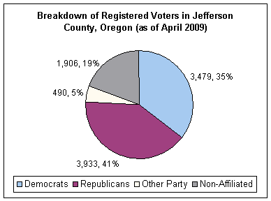
Though Jefferson County is located in central Oregon, politically it falls in line with the eastern side of the state. The majority of registered voters who are part of a political partyPolitical party
A political party is a political organization that typically seeks to influence government policy, usually by nominating their own candidates and trying to seat them in political office. Parties participate in electoral campaigns, educational outreach or protest actions...
in Jefferson County, as well as most counties in eastern Oregon, are members of the Republican Party
Republican Party (United States)
The Republican Party is one of the two major contemporary political parties in the United States, along with the Democratic Party. Founded by anti-slavery expansion activists in 1854, it is often called the GOP . The party's platform generally reflects American conservatism in the U.S...
. In the 2008 presidential election
United States presidential election, 2008
The United States presidential election of 2008 was the 56th quadrennial presidential election. It was held on November 4, 2008. Democrat Barack Obama, then the junior United States Senator from Illinois, defeated Republican John McCain, the senior U.S. Senator from Arizona. Obama received 365...
, 51.47% of Jefferson County voters voted for Republican John McCain
John McCain
John Sidney McCain III is the senior United States Senator from Arizona. He was the Republican nominee for president in the 2008 United States election....
, while 43.05% voted for Democrat
Democratic Party (United States)
The Democratic Party is one of two major contemporary political parties in the United States, along with the Republican Party. The party's socially liberal and progressive platform is largely considered center-left in the U.S. political spectrum. The party has the lengthiest record of continuous...
Barack Obama
Barack Obama
Barack Hussein Obama II is the 44th and current President of the United States. He is the first African American to hold the office. Obama previously served as a United States Senator from Illinois, from January 2005 until he resigned following his victory in the 2008 presidential election.Born in...
and 5.46% of voters either voted for a Third Party
Third party (politics)
In a two-party system of politics, the term third party is sometimes applied to a party other than the two dominant ones. While technically the term is limited to the third largest party or third oldest party, it is common, though innumerate, shorthand for any smaller party.For instance, in the...
candidate or wrote in
Write-in candidate
A write-in candidate is a candidate in an election whose name does not appear on the ballot, but for whom voters may vote nonetheless by writing in the person's name. Some states and local jurisdictions allow a voter to affix a sticker with a write-in candidate's name on it to the ballot in lieu...
a candidate. These numbers show a small shift towards the Democratic candidate as well as a Third Party candidate when compared to the 2004 presidential election
United States presidential election, 2004
The United States presidential election of 2004 was the United States' 55th quadrennial presidential election. It was held on Tuesday, November 2, 2004. Republican Party candidate and incumbent President George W. Bush defeated Democratic Party candidate John Kerry, the then-junior U.S. Senator...
, in which 58.7% of Jefferson Country voters voted for George W. Bush
George W. Bush
George Walker Bush is an American politician who served as the 43rd President of the United States, from 2001 to 2009. Before that, he was the 46th Governor of Texas, having served from 1995 to 2000....
, while 40% voted for John Kerry
John Kerry
John Forbes Kerry is the senior United States Senator from Massachusetts, the 10th most senior U.S. Senator and chairman of the Senate Foreign Relations Committee. He was the presidential nominee of the Democratic Party in the 2004 presidential election, but lost to former President George W...
, and 1.3% of voters either voted for a Third Party candidate or wrote in a candidate
Write-in candidate
A write-in candidate is a candidate in an election whose name does not appear on the ballot, but for whom voters may vote nonetheless by writing in the person's name. Some states and local jurisdictions allow a voter to affix a sticker with a write-in candidate's name on it to the ballot in lieu...
.
Geography
According to the U.S. Census BureauUnited States Census Bureau
The United States Census Bureau is the government agency that is responsible for the United States Census. It also gathers other national demographic and economic data...
, the county has a total area of 1791 square miles (4,638.7 km²), of which 1781 square miles (4,612.8 km²) is land and 10 square miles (25.9 km²) (0.58%) is water.
Adjacent counties
- Wheeler County, OregonWheeler County, OregonAs of the census of 2000, there were 1,547 people, 653 households, and 444 families residing in the county. The population density was 1 people per square mile . There were 842 housing units at an average density of 0 per square mile...
- (east) - Crook County, OregonCrook County, Oregon-Demographics:As of the census of 2000, there were 19,182 people, 7,354 households, and 5,427 families residing in the county. The population density was 6 people per square mile . There were 8,264 housing units at an average density of 3 per square mile...
- (south) - Deschutes County, OregonDeschutes County, Oregon-National protected areas:* Deschutes National Forest * Newberry National Volcanic Monument-Demographics:As of the census of 2000, there were 115,367 people, 45,595 households, and 31,962 families residing in the county. The population density was 38 people per square mile . There were 54,583...
- (south) - Linn County, OregonLinn County, OregonLinn County is a county located in the U.S. state of Oregon. It is named in honor of Lewis F. Linn, a U.S. Senator from Missouri who advocated the American occupation of the Oregon Country. By the 2010 US census the population of Linn county was 116,672 showing a 13.2% growth since the 2000 census...
- (west) - Marion County, OregonMarion County, OregonMarion County is a county located in the U.S. state of Oregon. It was originally named the Champooick District, after Champoeg, a meeting place on the Willamette River. On September 3, 1849, the territorial legislature renamed it in honor of Francis Marion, a Continental Army general of the...
- (northwest) - Wasco County, OregonWasco County, OregonWasco County is a county located in the U.S. state of Oregon. The county is named for a local tribe of Native Americans, the Wasco, a Chinook tribe who lived on the south side of the Columbia River. In 2010, its population was 25,213...
- (north)
National protected areas
- Crooked River National GrasslandCrooked River National GrasslandCrooked River National Grassland is a National Grassland located in Jefferson County in the north-central part of the U.S. state of Oregon. It has a land area of 112,357 acres . It contains two National Wild and Scenic Rivers, the Deschutes River and the Crooked River...
- Deschutes National ForestDeschutes National ForestThe Deschutes National Forest is a United States National Forest located in parts of Deschutes, Klamath, Lake, and Jefferson counties in central Oregon. It comprises 1.8 million acres along the east side of the Cascade mountains. In 1908, the Deschutes National Forest was established from parts...
(part) - Mount Hood National ForestMount Hood National ForestThe Mount Hood National Forest is located east of the city of Portland, Oregon, and the northern Willamette River valley. The Forest extends south from the Columbia River Gorge across more than of forested mountains, lakes and streams to the Olallie Scenic Area, a high lake basin under the slopes...
(part) - Willamette National ForestWillamette National ForestThe Willamette National Forest is a National Forest located in the central portion of the Cascade Range of US state of Oregon.It comprises 1,675,407 acres making it one of the largest national forests. Over 380,000 acres are designated wilderness which include seven major mountain peaks...
(part)
Demographics
As of the census
Census
A census is the procedure of systematically acquiring and recording information about the members of a given population. It is a regularly occurring and official count of a particular population. The term is used mostly in connection with national population and housing censuses; other common...
of 2000, there were 19,009 people, 6,727 households, and 5,166 families residing in the county. The population density
Population density
Population density is a measurement of population per unit area or unit volume. It is frequently applied to living organisms, and particularly to humans...
was 11 people per square mile (4/km²). There were 8,319 housing units at an average density of 5 per square mile (2/km²). The racial makeup of the county was 68.98% White
Race (United States Census)
Race and ethnicity in the United States Census, as defined by the Federal Office of Management and Budget and the United States Census Bureau, are self-identification data items in which residents choose the race or races with which they most closely identify, and indicate whether or not they are...
, 0.26% Black
Race (United States Census)
Race and ethnicity in the United States Census, as defined by the Federal Office of Management and Budget and the United States Census Bureau, are self-identification data items in which residents choose the race or races with which they most closely identify, and indicate whether or not they are...
or African American
Race (United States Census)
Race and ethnicity in the United States Census, as defined by the Federal Office of Management and Budget and the United States Census Bureau, are self-identification data items in which residents choose the race or races with which they most closely identify, and indicate whether or not they are...
, 15.68% Native American
Race (United States Census)
Race and ethnicity in the United States Census, as defined by the Federal Office of Management and Budget and the United States Census Bureau, are self-identification data items in which residents choose the race or races with which they most closely identify, and indicate whether or not they are...
, 0.30% Asian
Race (United States Census)
Race and ethnicity in the United States Census, as defined by the Federal Office of Management and Budget and the United States Census Bureau, are self-identification data items in which residents choose the race or races with which they most closely identify, and indicate whether or not they are...
, 0.22% Pacific Islander
Race (United States Census)
Race and ethnicity in the United States Census, as defined by the Federal Office of Management and Budget and the United States Census Bureau, are self-identification data items in which residents choose the race or races with which they most closely identify, and indicate whether or not they are...
, 11.32% from other races
Race (United States Census)
Race and ethnicity in the United States Census, as defined by the Federal Office of Management and Budget and the United States Census Bureau, are self-identification data items in which residents choose the race or races with which they most closely identify, and indicate whether or not they are...
, and 3.23% from two or more races. 17.74% of the population were Hispanic
Race (United States Census)
Race and ethnicity in the United States Census, as defined by the Federal Office of Management and Budget and the United States Census Bureau, are self-identification data items in which residents choose the race or races with which they most closely identify, and indicate whether or not they are...
or Latino
Race (United States Census)
Race and ethnicity in the United States Census, as defined by the Federal Office of Management and Budget and the United States Census Bureau, are self-identification data items in which residents choose the race or races with which they most closely identify, and indicate whether or not they are...
of any race. 13.6% were of German, 9.5% English
English people
The English are a nation and ethnic group native to England, who speak English. The English identity is of early mediaeval origin, when they were known in Old English as the Anglecynn. England is now a country of the United Kingdom, and the majority of English people in England are British Citizens...
, 8.7% American
United States
The United States of America is a federal constitutional republic comprising fifty states and a federal district...
and 5.3% Irish
Irish people
The Irish people are an ethnic group who originate in Ireland, an island in northwestern Europe. Ireland has been populated for around 9,000 years , with the Irish people's earliest ancestors recorded having legends of being descended from groups such as the Nemedians, Fomorians, Fir Bolg, Tuatha...
ancestry according to Census 2000. 82.2% spoke English
English language
English is a West Germanic language that arose in the Anglo-Saxon kingdoms of England and spread into what was to become south-east Scotland under the influence of the Anglian medieval kingdom of Northumbria...
, 15.5% Spanish
Spanish language
Spanish , also known as Castilian , is a Romance language in the Ibero-Romance group that evolved from several languages and dialects in central-northern Iberia around the 9th century and gradually spread with the expansion of the Kingdom of Castile into central and southern Iberia during the...
and 1.0% Sahaptian
Sahaptian languages
Sahaptian is a sub-grouping of two languages of the Plateau Penutian family spoken by Native American peoples in the Columbia Plateau region of Washington, Oregon, and Idaho in the northwestern United States.-Family division:Sahaptian includes 2 languages*Kittitas *Klickitat*Nez Percé**Nez Percé...
as their first language.
There were 6,727 households out of which 35.60% had children under the age of 18 living with them, 60.50% were married couples
Marriage
Marriage is a social union or legal contract between people that creates kinship. It is an institution in which interpersonal relationships, usually intimate and sexual, are acknowledged in a variety of ways, depending on the culture or subculture in which it is found...
living together, 10.50% had a female householder with no husband present, and 23.20% were non-families. 18.60% of all households were made up of individuals and 6.90% had someone living alone who was 65 years of age or older. The average household size was 2.80 and the average family size was 3.16.
In the county, the population was spread out with 29.80% under the age of 18, 7.70% from 18 to 24, 26.90% from 25 to 44, 23.20% from 45 to 64, and 12.40% who were 65 years of age or older. The median age was 35 years. For every 100 females there were 101.90 males. For every 100 females age 18 and over, there were 100.80 males.
The median income for a household in the county was $35,853, and the median income for a family was $39,151. Males had a median income of $31,126 versus $22,086 for females. The per capita income
Per capita income
Per capita income or income per person is a measure of mean income within an economic aggregate, such as a country or city. It is calculated by taking a measure of all sources of income in the aggregate and dividing it by the total population...
for the county was $15,675. About 10.40% of families and 14.60% of the population were below the poverty line, including 22.20% of those under age 18 and 5.90% of those age 65 or over.
Incorporated cities
- CulverCulver, OregonCulver is a city in Jefferson County, Oregon, United States. The population was 802 at the 2000 census, with an estimated population of 1,315 in 2007.- History :...
- MadrasMadras, OregonMadras is a city in Jefferson County, Oregon, United States. Originally called The Basin after the circular valley the city is located in, it is unclear as to whether Madras was named in 1903 for the cotton fabric called "Madras" that originated in the Madras area in India, or from the city of...
- MetoliusMetolius, OregonMetolius is a city in Jefferson County, Oregon, United States. The city is named for the Metolius River, a nearby tributary of the Deschutes River. The name for both comes from the Warm Springs word for "white fish", referring to a light colored salmon and not a whitefish...
Unincorporated communities and CDPs
|
|
Kilts, Oregon Kilts, formerly known as Axehandle and Donnybrook, is an unincorporated community in Jefferson County, Oregon, United States, named for its resident Jesse Kilts. Its post office operated from September 15, 1914 to June 29, 1940 and the first postmaster was Ruth A. Kilts.... Warm Springs, Oregon Warm Springs is a census-designated place and an unincorporated community in Jefferson County, Oregon, United States. Located on the Warm Springs Indian Reservation, the community is also known as the "Warm Springs Agency." The population was 2,431 at the 2000 census.-Geography:Warm Springs is... |
See also
- National Register of Historic Places listings in Jefferson County, Oregon