
Interstate 37
Encyclopedia
Interstate 37 is a 143 miles (230.1 km) intrastate Interstate Highway located within the U.S. state
of Texas
. The highway was first designated in 1959 as a route between Corpus Christi
and San Antonio. Construction in the urban areas of Corpus Christi and San Antonio began in the 1960s and the segments of the Interstate Highway in rural areas were completed by the 1980s. Prior to I-37, the route between Corpus Christi and San Antonio was served by a combination of State Highway 9 (SH 9) from Corpus Christi to Three Rivers
and U.S. 281
(US 281) from Three Rivers to San Antonio. As a result of the construction of I-37, SH 9 was removed from the State Highway System
.
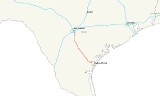
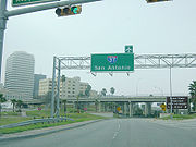
The highway's southern terminus is located in Corpus Christi at US 181
and SH 35, and heads north to San Antonio, where it ends at I-35
. The freeway continues as US 281 beyond I-35 to northern San Antonio as a major freeway. In Corpus Christi, the highway provides access to the downtown area, the Port of Corpus Christi
and the Corpus Christi International Airport
. In San Antonio, it provides access to downtown, Brooks City-Base
, the Alamodome
, the Tower of the Americas
, the River Walk
, the Alamo
, and by extension via US 281, the San Antonio International Airport
. The route provides an important connection between I-35 and the Texas Gulf Coast as well as one of the few limited-access
hurricane evacuation
routes away from the southern Texas coast.
and US 281
from Three Rivers to San Antonio. Beginning in 1971, sections of SH 9 were officially removed from the State Highway System as I-37 was completed. No sections of US 281 were removed from the State Highway System as a result of the construction of I-37, but the two do share the same alignment at two different points between San Antonio and Three Rivers. Also, US 281 was rerouted onto I-37 in San Antonio in 1978.
I-37 was first designated in 1959 to provide a route between San Antonio and Corpus Christi. Construction began in the 1960s and the route was completed by the 1980s. The first sections of the freeway completed were in Corpus Christi. The freeway was completed from its southern terminus to 1.2 miles (1.9 km) to the west at the Port Avenue overpass to include the SH 286 interchange in 1963. In 1964, the freeway was extended another 1.1 miles (1.8 km) westward with the completion of the overpasses at Nueces Bay Boulevard and Buddy Lawrence Boulevard. By 1965, the freeway had been extended west 1.4 miles (2.3 km) to Navigation Boulevard. In 1966, the interchange at SH 358 was complete, as were the mainlanes to Corn Products Road, 1 miles (1.6 km) west of the SH 358 interchange. By 1968, the freeway had been completed an additional 8.1 miles (13 km) further west to Callicoatte Road. The southbound I-37 bridge over the Nueces River
was built in 1933 for US 77 when it was first routed through Corpus Christi. The northbound bridge was built in 1958 with the expansion of US 77 to four lanes.
 Construction in San Antonio also began in the 1960s and was completed in 1972. The first sections were completed in 1967 to include the portion just south of I-410 at the US 181 interchange. The section from Steves Avenue north to Florida Street to include the I-10 interchange was also complete in 1967. In 1968, the section south of I-410 was extended south to Loop 1604. In 1969, the two sections were connected with the completion of overpasses at Goliad Road, Pecan Valley Drive, Fair Avenue and Hackberry Street as well as the completion of the interchanges at I-410 and Loop 13. The last sections left were on the east side of downtown. The downtown overpasses at Durango Boulevard, Commerce Street and the overpass stretching from Houston Street to Jones Avenue were all completed in 1972. The last portion completed in San Antonio was the stack interchange
at I-35. With the completion of the interchange in 1972, the city had a freeway loop in conjunction with I-10 and I-35 around the central business district of the city. At the time construction began in July 1969, the I-35 interchange was the largest highway construction project in state history at $11 million ($65 million in 2007).
 The rural sections of the freeway were completed later than those in the urban areas. Construction of the highway in Corpus Christi and Nueces County continued north over the Nueces River into San Patrico County. The interchange at US 77 was completed in 1969. The road that was already in existence along this stretch, SH 9, would be utilized as a frontage road as many of the bridges along this stretch were from when SH 9 was built in the 1930s. The main lanes were extended northward to SH 234
in 1969. By 1970, the freeway had been extended as far north as SH 188
. In 1971, I-37 reached FM 888 and service to the city of Mathis
. During the mid-1970s, the southern section and northern section were both being extended. The southern section was extended northward inn Live Oak County to US 59 in 1975 and FM 799 in 1976. The northern section saw completion in Atascosa County to FM 541 in 1975 and FM 1099 in 1976. By the early 1980s, the freeway was nearly complete. In 1980, the interchange at US 281 southeast of Pleasanton
was complete. With the completion of the interchange at SH 72 and other bridges in the Pleasanton area in 1981, I-37 was complete.
 I-37 begins in Corpus Christi on the Gulf Coast and heads north to San Antonio. It is the main route between I-35
and the Gulf of Mexico
and the Rio Grande Valley
cities of Brownsville
and McAllen
via US 281 and US 77. The highway also functions as one of the few freeway hurricane evacuation routes for the southern Texas coast. The Interstate roughly parallels US 181 and US 281 and in fact, US 181 both begins and ends at I-37.
The southern terminus of I-37 is at a junction with US 181 and SH 35 near the Corpus Christi Bay
in Corpus Christi. I-37 heads west from US 181 through Corpus Christi, intersecting two freeways, SH 286
(Crosstown Expressway) and SH 358
(Padre Island Drive). The highway turns towards the northwest after the SH 358 interchange roughly paralleling to the south of the Nueces River
. Just prior to leaving the Corpus Christi city limits, I-37 intersects and has a short concurrency with US 77. US 77 merges with I-37 as a freeway from the south; the two continue to the north and split after crossing the Nueces River. I-37 continues to the northwest as US 77 continues to the northeast.
I-37 transitions to a rural setting once outside of the Corpus Christi city limits on its way to Mathis
and Lake Corpus Christi
. It continues on to the northwest and intersects US 59 east of George West
. I-37 begins paralleling US 281 to the east before the two intersect and have a concurrency north of Three Rivers
near Choke Canyon Reservoir
. U.S. Highway 281 Alternate splits off from I-37 near Sunniland and parallels I-37 before rejoining north of Campbellton
. I-37 and US 281 remain concurrent until US 281 splits off to head to Pleasanton
, while I-37 bypasses the city to the east. After US 281 leaves towards the northwest, I-37 turns to the north heading towards San Antonio
.
 As I-37 enters the San Antonio city limits, it intersects the northern terminus of US 181. Continuing to the north, I-37 intersects I-410, the inner loop around San Antonio, at a stack interchange
. At this junction, I-37 once again runs concurrently with US 281 which had been concurrent with I-410. Heading north through the south side of San Antonio, I-37 provides access to Brooks City-Base
(formerly Brooks AFB). After a cloverleaf interchange
at Loop 13
, I-37 turns towards the northwest. The highway intersects I-10
, which is concurrent with US 90 and US 87, at a stack interchange south of downtown. After the interchange, I-37 is once again heading north on the east side of downtown. It passes near the Alamodome
, the Tower of the Americas
, the River Walk
and the Alamo
. I-37 comes to an end northeast of downtown at a junction with I-35. US 281 continues to the north as a freeway providing access to the San Antonio International Airport
.
I-37 in San Antonio from I-410 to I-10 is designated the Lucian Adams Freeway, after the World War II
veteran. Adams is a native of Port Arthur
, and received the Medal of Honor
for his service in France, along with the Bronze Star
and Purple Heart
for his gallantry during the Cassino Campaign
. From I-10 to its northern terminus at I-35, it is designated the Staff Sergeant William J. Bordelon
Freeway. Bordelon was the first San Antonio native to receive the Medal of Honor
after being killed in action during World War II
.
U.S. state
A U.S. state is any one of the 50 federated states of the United States of America that share sovereignty with the federal government. Because of this shared sovereignty, an American is a citizen both of the federal entity and of his or her state of domicile. Four states use the official title of...
of Texas
Texas
Texas is the second largest U.S. state by both area and population, and the largest state by area in the contiguous United States.The name, based on the Caddo word "Tejas" meaning "friends" or "allies", was applied by the Spanish to the Caddo themselves and to the region of their settlement in...
. The highway was first designated in 1959 as a route between Corpus Christi
Corpus Christi, Texas
Corpus Christi is a coastal city in the South Texas region of the U.S. state of Texas. The county seat of Nueces County, it also extends into Aransas, Kleberg, and San Patricio counties. The MSA population in 2008 was 416,376. The population was 305,215 at the 2010 census making it the...
and San Antonio. Construction in the urban areas of Corpus Christi and San Antonio began in the 1960s and the segments of the Interstate Highway in rural areas were completed by the 1980s. Prior to I-37, the route between Corpus Christi and San Antonio was served by a combination of State Highway 9 (SH 9) from Corpus Christi to Three Rivers
Three Rivers, Texas
Three Rivers is a city in Live Oak County, Texas, United States. The population was 1,878 at the 2000 census.The city is named for its proximity to three rivers, the Atascosa River, the Frio River, and the Nueces River...
and U.S. 281
U.S. Route 281
U.S. Route 281 is a north–south United States highway. At 1,872 miles long it is the longest continuous three-digit U.S. Route....
(US 281) from Three Rivers to San Antonio. As a result of the construction of I-37, SH 9 was removed from the State Highway System
Texas state highways
Texas state highways are a network of highways owned and maintained by the U.S. state of Texas. The Texas Department of Transportation is the state agency responsible for the day-to-day operations and maintenance of the system. In addition to the nationally-numbered Interstate highways and U.S...
.
The highway's southern terminus is located in Corpus Christi at US 181
U.S. Route 181
U.S. Highway 181, a north–south route, is one of many intrastate United States Highways in the United States. It lies completely within the state of Texas, and both termini are at Interstate 37, the road that it mainly parallels to the east...
and SH 35, and heads north to San Antonio, where it ends at I-35
Interstate 35 in Texas
Interstate 35 in Texas is a major north–south Interstate Highway running from Laredo near the United States-Mexico border to the Red River north of Gainesville where it crosses into Oklahoma. Along its route, it passes through the cities of San Antonio, Austin, and Waco before it splits into two...
. The freeway continues as US 281 beyond I-35 to northern San Antonio as a major freeway. In Corpus Christi, the highway provides access to the downtown area, the Port of Corpus Christi
Port of Corpus Christi
* Port Corpus Christi is the 5th largest port in the United States in total tonnage . Port Corpus Christi is located on Corpus Christi Bay in the western Gulf of Mexico, with a straight 45’ deep channel. The Port is located close to downtown Corpus Christi, Texas, Nueces County, Texas; but the...
and the Corpus Christi International Airport
Corpus Christi International Airport
Corpus Christi International Airport is a city-owned public-use airport located five nautical miles west of the central business district of Corpus Christi, in Nueces County, Texas, United States.The airport's new six gate, . Hayden W...
. In San Antonio, it provides access to downtown, Brooks City-Base
Brooks City-Base
Brooks City-Base was a United States Air Force facility located in San Antonio, Texas, southeast of Downtown San Antonio.In 2002 Brooks Air Force Base was renamed Brooks City-Base when the property was conveyed to the Brooks Development Authority as part of a unique project between local, state,...
, the Alamodome
Alamodome
The Alamodome is a domed 65,000 seat, multi-purpose facility that is primarily used as a football/basketball stadium and convention center in San Antonio, Texas, U.S...
, the Tower of the Americas
Tower of the Americas
Tower of the Americas is a 750-foot observation tower/restaurant in San Antonio, Texas. The tower was designed by San Antonio architect O'Neil Ford and was built as the theme structure of the 1968 World's Fair, HemisFair '68....
, the River Walk
San Antonio River Walk
The San Antonio River Walk is a network of walkways along the banks of the San Antonio River, one story beneath downtown San Antonio, Texas...
, the Alamo
Alamo
The Battle of the Alamo was a battle fought during the Texas Revolution.Alamo may also refer to:-Places:*Alamo Mission in San Antonio, Texas*Alamo, California*Alamo, Georgia*Alamo Township, Michigan*Alamo, Nevada*Alamo, New Mexico...
, and by extension via US 281, the San Antonio International Airport
San Antonio International Airport
San Antonio International Airport is a commercial airport in San Antonio, Texas, USA. The airport has three runways and covers . Its elevation is above sea level. SAT is a Class C airport.- Overview :...
. The route provides an important connection between I-35 and the Texas Gulf Coast as well as one of the few limited-access
Limited-access road
A limited-access road known by various terms worldwide, including limited-access highway, dual-carriageway and expressway, is a highway or arterial road for high-speed traffic which has many or most characteristics of a controlled-access highway , including limited or no access to adjacent...
hurricane evacuation
Emergency evacuation
Emergency evacuation is the immediate and rapid movement of people away from the threat or actual occurrence of a hazard. Examples range from the small scale evacuation of a building due to a bomb threat or fire to the large scale evacuation of a district because of a flood, bombardment or...
routes away from the southern Texas coast.
History
Prior to I-37, the routing between Corpus Christi and San Antonio was covered by SH 9 from Corpus Christi to Three RiversThree Rivers, Texas
Three Rivers is a city in Live Oak County, Texas, United States. The population was 1,878 at the 2000 census.The city is named for its proximity to three rivers, the Atascosa River, the Frio River, and the Nueces River...
and US 281
U.S. Route 281
U.S. Route 281 is a north–south United States highway. At 1,872 miles long it is the longest continuous three-digit U.S. Route....
from Three Rivers to San Antonio. Beginning in 1971, sections of SH 9 were officially removed from the State Highway System as I-37 was completed. No sections of US 281 were removed from the State Highway System as a result of the construction of I-37, but the two do share the same alignment at two different points between San Antonio and Three Rivers. Also, US 281 was rerouted onto I-37 in San Antonio in 1978.
I-37 was first designated in 1959 to provide a route between San Antonio and Corpus Christi. Construction began in the 1960s and the route was completed by the 1980s. The first sections of the freeway completed were in Corpus Christi. The freeway was completed from its southern terminus to 1.2 miles (1.9 km) to the west at the Port Avenue overpass to include the SH 286 interchange in 1963. In 1964, the freeway was extended another 1.1 miles (1.8 km) westward with the completion of the overpasses at Nueces Bay Boulevard and Buddy Lawrence Boulevard. By 1965, the freeway had been extended west 1.4 miles (2.3 km) to Navigation Boulevard. In 1966, the interchange at SH 358 was complete, as were the mainlanes to Corn Products Road, 1 miles (1.6 km) west of the SH 358 interchange. By 1968, the freeway had been completed an additional 8.1 miles (13 km) further west to Callicoatte Road. The southbound I-37 bridge over the Nueces River
Nueces River
The Nueces River is a river in the U.S. state of Texas, approximately long. It drains a region in central and southern Texas southeastward into the Gulf of Mexico. It is the southernmost major river in Texas northeast of the Rio Grande...
was built in 1933 for US 77 when it was first routed through Corpus Christi. The northbound bridge was built in 1958 with the expansion of US 77 to four lanes.
Stack interchange
A stack interchange is a free-flowing grade separated junction between two roads.In countries where one drives on the right, left turns are handled by semi-directional flyover/under ramps...
at I-35. With the completion of the interchange in 1972, the city had a freeway loop in conjunction with I-10 and I-35 around the central business district of the city. At the time construction began in July 1969, the I-35 interchange was the largest highway construction project in state history at $11 million ($65 million in 2007).
Texas State Highway 234
State Highway 234 is a short state highway connecting Edroy and Odem in San Patricio County, Texas.-Route description:SH 234 begins in Edroy at southbound's exit #22; the roadway north of this interchange is designated . The route travels south into central Edroy before turning to the east, where...
in 1969. By 1970, the freeway had been extended as far north as SH 188
Texas State Highway 188
State Highway 188 or SH 188 is a Texas state highway running from Mathis east to the Gulf of Mexico near Port Aransas. This route was designated in 1993, replacing FM 881 and part of FM 1069.-Previous routes:...
. In 1971, I-37 reached FM 888 and service to the city of Mathis
Mathis, Texas
Mathis is a city in San Patricio County, Texas, United States. The population was 5,034 at the 2000 census.In 1887 when the San Antonio and Aransas Pass Railroad was laying tracks across San Patricio County, Thomas H. Mathis got naming rights when he donated for a townsite and school. Mathis could...
. During the mid-1970s, the southern section and northern section were both being extended. The southern section was extended northward inn Live Oak County to US 59 in 1975 and FM 799 in 1976. The northern section saw completion in Atascosa County to FM 541 in 1975 and FM 1099 in 1976. By the early 1980s, the freeway was nearly complete. In 1980, the interchange at US 281 southeast of Pleasanton
Pleasanton, Texas
Pleasanton is a city in Atascosa County, Texas, United States. The population was 8,266 at the 2000 census. Pleasanton's official motto is "The City of Live Oaks and Friendly Folks." It is part of the San Antonio-New Braunfels Metropolitan Statistical Area....
was complete. With the completion of the interchange at SH 72 and other bridges in the Pleasanton area in 1981, I-37 was complete.
Route description
Interstate 35 in Texas
Interstate 35 in Texas is a major north–south Interstate Highway running from Laredo near the United States-Mexico border to the Red River north of Gainesville where it crosses into Oklahoma. Along its route, it passes through the cities of San Antonio, Austin, and Waco before it splits into two...
and the Gulf of Mexico
Gulf of Mexico
The Gulf of Mexico is a partially landlocked ocean basin largely surrounded by the North American continent and the island of Cuba. It is bounded on the northeast, north and northwest by the Gulf Coast of the United States, on the southwest and south by Mexico, and on the southeast by Cuba. In...
and the Rio Grande Valley
Rio Grande Valley
The Rio Grande Valley or the Lower Rio Grande Valley, informally called The Valley, is an area located in the southernmost tip of South Texas...
cities of Brownsville
Brownsville, Texas
Brownsville is a city in the southernmost tip of the state of Texas, in the United States. It is located on the northern bank of the Rio Grande, directly north and across the border from Matamoros, Tamaulipas, Mexico. Brownsville is the 16th largest city in the state of Texas with a population of...
and McAllen
McAllen, Texas
McAllen is the largest city in Hidalgo County, Texas, United States. It is located at the southern tip of Texas in an area known as the Rio Grande Valley and is part of the . Its southern boundary is located about five miles from the U.S.–Mexico border and the Mexican city of Reynosa, the Rio...
via US 281 and US 77. The highway also functions as one of the few freeway hurricane evacuation routes for the southern Texas coast. The Interstate roughly parallels US 181 and US 281 and in fact, US 181 both begins and ends at I-37.
The southern terminus of I-37 is at a junction with US 181 and SH 35 near the Corpus Christi Bay
Corpus Christi Bay
Corpus Christi Bay is a scenic semi-tropical bay on the Texas coast found in San Patricio and Nueces counties, next to the major city of Corpus Christi. It is separated from the Gulf of Mexico by Mustang Island, and is fed by the Nueces River and Oso Creek from its western and southern extensions,...
in Corpus Christi. I-37 heads west from US 181 through Corpus Christi, intersecting two freeways, SH 286
Texas State Highway 286
State Highway 286 or SH 286 is a Texas state highway running from downtown Corpus Christi south to Chapman Ranch. The route was designated on its current route in 1939. Before 1939, this route was known as SH 96, and was proposed to be extended to the southwest to Riviera...
(Crosstown Expressway) and SH 358
Texas State Highway 358
State Highway 358 or SH 358 is a Texas state highway that runs along the southern edge of Corpus Christi. The route was designated in 1946 from SH 286 to the Naval Air Station, replacing FM 693. It was extended northwest to Interstate 37 in 1958, replacing FM 891. It is also known as Padre...
(Padre Island Drive). The highway turns towards the northwest after the SH 358 interchange roughly paralleling to the south of the Nueces River
Nueces River
The Nueces River is a river in the U.S. state of Texas, approximately long. It drains a region in central and southern Texas southeastward into the Gulf of Mexico. It is the southernmost major river in Texas northeast of the Rio Grande...
. Just prior to leaving the Corpus Christi city limits, I-37 intersects and has a short concurrency with US 77. US 77 merges with I-37 as a freeway from the south; the two continue to the north and split after crossing the Nueces River. I-37 continues to the northwest as US 77 continues to the northeast.
I-37 transitions to a rural setting once outside of the Corpus Christi city limits on its way to Mathis
Mathis, Texas
Mathis is a city in San Patricio County, Texas, United States. The population was 5,034 at the 2000 census.In 1887 when the San Antonio and Aransas Pass Railroad was laying tracks across San Patricio County, Thomas H. Mathis got naming rights when he donated for a townsite and school. Mathis could...
and Lake Corpus Christi
Lake Corpus Christi
Lake Corpus Christi is a reservoir in coastal southern Texas. The lake was created in by the impounding of Wesley E. Seale Dam. The lake and the dam that creates it are managed by the City of Corpus Christi. Lake Corpus Christi was originally known as Lake Lovenskiold...
. It continues on to the northwest and intersects US 59 east of George West
George West, Texas
George West is a city in Live Oak County, Texas, United States. The population was 2,524 at the 2000 census. It is the county seat of Live Oak County. George West was named the "storytelling capital of Texas" in 2005 by the Texas Senate; and it hosts the George West Storyfest, a festival that...
. I-37 begins paralleling US 281 to the east before the two intersect and have a concurrency north of Three Rivers
Three Rivers, Texas
Three Rivers is a city in Live Oak County, Texas, United States. The population was 1,878 at the 2000 census.The city is named for its proximity to three rivers, the Atascosa River, the Frio River, and the Nueces River...
near Choke Canyon Reservoir
Choke Canyon Reservoir
Choke Canyon Reservoir is a reservoir in southern Texas, USA. The lake and the dam that creates it are managed by the City of Corpus Christi.- Geography :...
. U.S. Highway 281 Alternate splits off from I-37 near Sunniland and parallels I-37 before rejoining north of Campbellton
Campbellton, Texas
Campbellton is an unincorporated community in Atascosa County, Texas, United States. An Irish immigrant, John F. Campbell, began the community in the 1860's by promoting settlement in the area. According to the Handbook of Texas, the community had an estimated population of 350 in 2000.It is...
. I-37 and US 281 remain concurrent until US 281 splits off to head to Pleasanton
Pleasanton, Texas
Pleasanton is a city in Atascosa County, Texas, United States. The population was 8,266 at the 2000 census. Pleasanton's official motto is "The City of Live Oaks and Friendly Folks." It is part of the San Antonio-New Braunfels Metropolitan Statistical Area....
, while I-37 bypasses the city to the east. After US 281 leaves towards the northwest, I-37 turns to the north heading towards San Antonio
San Antonio, Texas
San Antonio is the seventh-largest city in the United States of America and the second-largest city within the state of Texas, with a population of 1.33 million. Located in the American Southwest and the south–central part of Texas, the city serves as the seat of Bexar County. In 2011,...
.
Stack interchange
A stack interchange is a free-flowing grade separated junction between two roads.In countries where one drives on the right, left turns are handled by semi-directional flyover/under ramps...
. At this junction, I-37 once again runs concurrently with US 281 which had been concurrent with I-410. Heading north through the south side of San Antonio, I-37 provides access to Brooks City-Base
Brooks City-Base
Brooks City-Base was a United States Air Force facility located in San Antonio, Texas, southeast of Downtown San Antonio.In 2002 Brooks Air Force Base was renamed Brooks City-Base when the property was conveyed to the Brooks Development Authority as part of a unique project between local, state,...
(formerly Brooks AFB). After a cloverleaf interchange
Cloverleaf interchange
A cloverleaf interchange is a two-level interchange in which left turns, reverse direction in left-driving regions, are handled by ramp roads...
at Loop 13
Texas State Highway Loop 13
Loop 13 is a partial loop route around the city of San Antonio in the U.S. state of Texas. Prior to Interstate 410 , Loop 13 served as the primary loop for the city. Loop 13 follows Military Drive from U.S. Highway 90 through the south side of the city. It then follows W.W. White road after it...
, I-37 turns towards the northwest. The highway intersects I-10
Interstate 10 in Texas
Interstate 10 is the major east–west Interstate Highway in the Southern United States. In the U.S. state of Texas, it runs east from El Paso, near the border with New Mexico, through San Antonio and Houston to the border with Louisiana in Orange, Texas....
, which is concurrent with US 90 and US 87, at a stack interchange south of downtown. After the interchange, I-37 is once again heading north on the east side of downtown. It passes near the Alamodome
Alamodome
The Alamodome is a domed 65,000 seat, multi-purpose facility that is primarily used as a football/basketball stadium and convention center in San Antonio, Texas, U.S...
, the Tower of the Americas
Tower of the Americas
Tower of the Americas is a 750-foot observation tower/restaurant in San Antonio, Texas. The tower was designed by San Antonio architect O'Neil Ford and was built as the theme structure of the 1968 World's Fair, HemisFair '68....
, the River Walk
San Antonio River Walk
The San Antonio River Walk is a network of walkways along the banks of the San Antonio River, one story beneath downtown San Antonio, Texas...
and the Alamo
Alamo Mission in San Antonio
The Alamo, originally known as Mission San Antonio de Valero, is a former Roman Catholic mission and fortress compound, site of the Battle of the Alamo in 1836, and now a museum, in San Antonio, Texas....
. I-37 comes to an end northeast of downtown at a junction with I-35. US 281 continues to the north as a freeway providing access to the San Antonio International Airport
San Antonio International Airport
San Antonio International Airport is a commercial airport in San Antonio, Texas, USA. The airport has three runways and covers . Its elevation is above sea level. SAT is a Class C airport.- Overview :...
.
I-37 in San Antonio from I-410 to I-10 is designated the Lucian Adams Freeway, after the World War II
World War II
World War II, or the Second World War , was a global conflict lasting from 1939 to 1945, involving most of the world's nations—including all of the great powers—eventually forming two opposing military alliances: the Allies and the Axis...
veteran. Adams is a native of Port Arthur
Port Arthur, Texas
-Demographics:As of the 2000 census, there were 57,755 people, 21,839 households, and 14,675 families residing in the city. The population density was 696.5 people per square mile . There were 24,713 housing units at an average density of 298.0 per square mile...
, and received the Medal of Honor
Medal of Honor
The Medal of Honor is the highest military decoration awarded by the United States government. It is bestowed by the President, in the name of Congress, upon members of the United States Armed Forces who distinguish themselves through "conspicuous gallantry and intrepidity at the risk of his or her...
for his service in France, along with the Bronze Star
Bronze Star Medal
The Bronze Star Medal is a United States Armed Forces individual military decoration that may be awarded for bravery, acts of merit, or meritorious service. As a medal it is awarded for merit, and with the "V" for valor device it is awarded for heroism. It is the fourth-highest combat award of the...
and Purple Heart
Purple Heart
The Purple Heart is a United States military decoration awarded in the name of the President to those who have been wounded or killed while serving on or after April 5, 1917 with the U.S. military. The National Purple Heart Hall of Honor is located in New Windsor, New York...
for his gallantry during the Cassino Campaign
Battle of Monte Cassino
The Battle of Monte Cassino was a costly series of four battles during World War II, fought by the Allies against Germans and Italians with the intention of breaking through the Winter Line and seizing Rome.In the beginning of 1944, the western half of the Winter Line was being anchored by Germans...
. From I-10 to its northern terminus at I-35, it is designated the Staff Sergeant William J. Bordelon
William J. Bordelon
....
Freeway. Bordelon was the first San Antonio native to receive the Medal of Honor
Medal of Honor
The Medal of Honor is the highest military decoration awarded by the United States government. It is bestowed by the President, in the name of Congress, upon members of the United States Armed Forces who distinguish themselves through "conspicuous gallantry and intrepidity at the risk of his or her...
after being killed in action during World War II
World War II
World War II, or the Second World War , was a global conflict lasting from 1939 to 1945, involving most of the world's nations—including all of the great powers—eventually forming two opposing military alliances: the Allies and the Axis...
.
Exit list
| County | Location | # Exit number An exit number is a number assigned to a road junction, usually an exit from a freeway. It is usually marked on the same sign as the destinations of the exit, as well as a sign in the gore.... |
Destinations | Notes |
|---|---|---|---|---|
| Nueces | Corpus Christi Corpus Christi, Texas Corpus Christi is a coastal city in the South Texas region of the U.S. state of Texas. The county seat of Nueces County, it also extends into Aransas, Kleberg, and San Patricio counties. The MSA population in 2008 was 416,376. The population was 305,215 at the 2010 census making it the... |
Southbound exit and northbound entrance | ||
| 1A | Buffalo Street | Southbound exit and northbound entrance | ||
| 1B | Brownlee Boulevard, Port Avenue | Northbound exit and southbound entrance | ||
| 1C | ||||
| 1D | Port Avenue | Southbound exit and northbound entrance | ||
| 1E | Lawrence Drive, Nueces Bay Boulevard | |||
| 2 | Up River Road | |||
| 3A | Navigation Boulevard | |||
| 3B | McBride Lane, Lantana Street | Northbound exit and southbound entrance | ||
| 4A | – NAS Corpus Christi Naval Air Station Corpus Christi Naval Air Station Corpus Christi , also known as Truax Field, is a naval base located six miles southeast of the central business district of Corpus Christi, in Nueces County, Texas, USA.-History:... , Padre Island Padre Island Padre Island is part of the U.S. state of Texas. The island is located on Texas' southern coast of the Gulf of Mexico and is famous for its white sandy beaches at the south end... |
|||
| 4B | Lantana Street, McBride Lane | Southbound exit and northbound entrance | ||
| 5 | Corn Products Road | |||
| 6 | Southern Minerals Road | |||
| 7 | Tuloso Road, Suntide Road | |||
| 9 | ||||
| 10 | Carbon Plant Road | |||
| 11A | ||||
| 11B | ||||
| 13A | ||||
| 13B | Sharpsburg Road | Northbound exit and southbound entrance | ||
| 14A | South end of US 77 overlap; signed as exit 14 southbound | |||
| 14B | Red Bird Lane | Northbound exit and southbound entrance | ||
| 15 | Sharpsburg Road, Red Bird Lane | Southbound exit and northbound entrance | ||
| 16 | Nueces River Park | |||
| San Patricio | 17 | North end of US 77 overlap | ||
| 20A | Picnic Area | |||
| 20B | Cooper Road | |||
| Edroy Edroy, Texas Edroy is a census-designated place in San Patricio County, Texas, United States. The population was 420 at the 2000 census.-Geography:Edroy is located at .... |
22 | |||
| 31 | ||||
| Mathis Mathis, Texas Mathis is a city in San Patricio County, Texas, United States. The population was 5,034 at the 2000 census.In 1887 when the San Antonio and Aransas Pass Railroad was laying tracks across San Patricio County, Thomas H. Mathis got naming rights when he donated for a townsite and school. Mathis could... |
34 | |||
| 36 | ||||
| Live Oak | 40 | |||
| 47 | ||||
| 51 | Hailey Ranch Road | |||
| 56 | ||||
| 59 | ||||
| 65 | ||||
| 69 | ||||
| 72 | South end of US 281 overlap | |||
| 76 | ||||
| 83 | ||||
| Atascosa | 88 | |||
| 92 | Southbound exit and northbound entrance | |||
| 98 | ||||
| 103 | North end of US 281 overlap; northbound exit and southbound entrance | |||
| 104 | No southbound entrance | |||
| 106 | Coughran Road | |||
| 109 | ||||
| 113 | ||||
| 117 | ||||
| Bexar Bexar County, Texas As of the census of 2000, there were 1,392,931 people, 488,942 households, and 345,681 families residing in the county. The population density was 1,117 people per square mile . There were 521,359 housing units at an average density of 418 per square mile... |
120 | Hardy Road | ||
| 122 | Priest Road | |||
| 125 | ||||
| 127 | San Antonio River San Antonio River The San Antonio River is a major waterway that originates in central Texas in a cluster of springs in north central San Antonio, approximately four miles north of downtown, and follows a roughly southeastern path through the state. It eventually feeds into the Guadalupe River about ten miles from... Turnaround |
Northbound exit and southbound entrance | ||
| San Antonio | 130 | Southton Road, Donop Road | ||
| 132 | Northbound exit and southbound entrance | |||
| 132 | Southbound exit and northbound entrance | |||
| 133 | South end of US 281 overlap | |||
| 135 | – Brooks City-Base Brooks City-Base Brooks City-Base was a United States Air Force facility located in San Antonio, Texas, southeast of Downtown San Antonio.In 2002 Brooks Air Force Base was renamed Brooks City-Base when the property was conveyed to the Brooks Development Authority as part of a unique project between local, state,... |
|||
| 136 | Pecan Valley Drive | |||
| 137 | Hot Wells Boulevard | |||
| 138 | New Braunfels Avenue, Southcross Boulevard | Signed as exits 138A (east) and 138B (west) southbound | ||
| 138C | Fair Avenue, Hackberry Street | |||
| 139 | ||||
| 140A | Florida Street, Carolina Street | |||
| 140B | Durango Boulevard – Alamodome Alamodome The Alamodome is a domed 65,000 seat, multi-purpose facility that is primarily used as a football/basketball stadium and convention center in San Antonio, Texas, U.S... |
|||
| 141A | Commerce Street – Downtown San Antonio Downtown San Antonio Downtown San Antonio is the central business district of San Antonio, Texas, United States.Downtown is encircled by three numerical freeways, I-35, I-37, and I-10... , The Alamo |
Signed as exit 141 southbound | ||
| 141B | Houston Street – The Alamo | Southbound exit and northbound entrance | ||
| 141C | McCullough Avenue, Nolan Street | Southbound exit and northbound entrance | ||
| 142 | Signed as exits 142A (north) and 142B (south) | |||
| , San Antonio International Airport San Antonio International Airport San Antonio International Airport is a commercial airport in San Antonio, Texas, USA. The airport has three runways and covers . Its elevation is above sea level. SAT is a Class C airport.- Overview :... |
Continuation beyond I-35 |