

Highway route markers
Encyclopedia
Highway route markers are the modern-day equivalent of milestone
s. Unlike traditional milestones, however, which (as their name suggests) were originally carved from stone and sited at one-mile intervals, modern highway route markers are made from a variety of materials and are almost invariably (except in the United States, where miles are used) spaced at intervals of a kilometre or a fraction thereof.
In most cases they had the name of the town or city to which they headed, for example The Old Portsmouth Road
. Other ancient highway names include The Pilgrims Way
, Watling Street
and the Via Appia
.
However, with the increase in private traffic after the First World War a simpler way of identifying roads was needed. Different countries adopted different ways of identifying roads. Under the 1966 Local Government Act Great Britain
[excluding Northern Ireland
] adopted a system of road numbering so that each roads had a unique number across the entire country. The relative importance of the road was identified by a “A” or a “B” prefix.
In France
roads that were in the care of the national government were prefixed by “RN” (later just “N”) and had a number that was unique across all of France. Roads that were maintained by departments had a number that was prefixed by “D” and were unique within the department concerned while roads that were maintained by communes
had numbers that were prefixed by a “C” were unique within a commune. The advent of motorways meant an extension to both the British and the French methods of roads identification.
Highway route identifiers often have the route identifier marked on them.
A highway may be divided into more than one sector, with different sector having different numbering sequences (though it is possible, as will be explained later for two sectors to share a sequence). Sector boundaries could be the boundaries of a state (as is the case of the United States Interstate highway system), or could be the middle of a large town or any one of a number of other locations.
Each numbering sequence is defined by its reference point
and all the numbers within one sequence having a fixed relationship to the reference point and hence to each other (such as being at 0.1 km intervals). The reference point might be the start of the highway, it might be the start of the sector or it might be some artificial point that is located before the start of the highway. Such artificial points include the Zero Milestone
in Washington, D.C.
and Charing Cross
in London
.
In some countries such as Spain
or the United States
, highway Exit number
are identified using location identifiers.
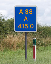 Major British roads have marker posts at 100 metre intervals. These posts, which are used for administrative purposes, give the distance in kilometres from some reference point. The digits on the posts are not designed to be used by the general public. There are no fixed rules for such reference points: they may be the centre of a city, an administrative boundary or follow some other rule. Marker posts on motorways also have arrows that point to the closest emergency telephone. The markerpost in the picture is on a trunk road
, not a motorway and hence has no arrow. It is however unusual in that it has the highway identifier (A38) and carriageway identifier (A) in addition to the location identification (415.0).
The advent of the mobile phone required a government rethink regarding marker posts. This has led to the erection of driver location signs in England (but at the time of writing, not in Scotland, Wales or Northern Ireland)
at about 500 metre (about 1/3 mile) intervals on many motorways.
Driver location signs have three pieces of information:
The location is identical to the location given on marker posts. The most commonly used carriageway identifiers are the letters “A”, “B”, “J”, “K”, “L” and “M”.
The letter “A” normally denotes the carriageway in the direction of increasing location numbers (usually away from London), “B” the carriageway in the direction of decreasing location numbers while “J”, “K”, “L” and “M” denote junction slip roads.
markers are spaced at 100 m intervals. In addition to having the motorway number and location on them, they also have a carriageway identifier – Li for Links (Left) and Re for Rechts (Right). The carriageways are identified as being left-hand and right-hand as viewed by somebody looking in the direction of increasing location numbers. By and large, Dutch location numbers increase as one moves away from Amsterdam, or in the case of roads that do not originate in Amsterdam, location numbers increase as one moves eastwards away from the North Sea. Carriageway identifiers “a”, “b”, “c” and “d” are used to identify slip roads on and off the motorway.
Another novel concept on Dutch hectometre markers is that speed limits are displayed on the marker boards when speed limit is not the national default of 120 km/h. This is shown on the accompanying illustration. Pictures of the normal boards can be found in main article.
s, including U.S. Routes and Interstate Highways. The postmile markers indicate the distance a route travels through individual counties, as opposed to mile markers that indicate the distance traveled through a state.

Region, and the third row the control segment and distance from the segment start. The control segment has one digit while the distance from the start of the segment has three digits and is given in units of tenths of a mile.
 The Indian route markers carry a number of different distances. The marker illustrated carries the following information:
Although the sign illustrated uses Latin script, a number of Indian location markers use the Indian national language Hindi
.
Milestone
A milestone is one of a series of numbered markers placed along a road or boundary at intervals of one mile or occasionally, parts of a mile. They are typically located at the side of the road or in a median. They are alternatively known as mile markers, mileposts or mile posts...
s. Unlike traditional milestones, however, which (as their name suggests) were originally carved from stone and sited at one-mile intervals, modern highway route markers are made from a variety of materials and are almost invariably (except in the United States, where miles are used) spaced at intervals of a kilometre or a fraction thereof.
Route identification
Until the beginning of the twentieth century, highways were usually named rather than numbered.In most cases they had the name of the town or city to which they headed, for example The Old Portsmouth Road
A3 road
The A3, known as the Portsmouth Road for much of its length, is a dual carriageway, or expressway, which follows the historic route between London and Portsmouth passing close to Kingston upon Thames, Guildford, Haslemere and Petersfield. For much of its length, it is classified as a trunk road...
. Other ancient highway names include The Pilgrims Way
Pilgrims' Way
The Pilgrims' Way is the historic route supposed to have been taken by pilgrims from Winchester in Hampshire, England, to the shrine of Thomas Becket at Canterbury in Kent...
, Watling Street
Watling Street
Watling Street is the name given to an ancient trackway in England and Wales that was first used by the Britons mainly between the modern cities of Canterbury and St Albans. The Romans later paved the route, part of which is identified on the Antonine Itinerary as Iter III: "Item a Londinio ad...
and the Via Appia
Appian Way
The Appian Way was one of the earliest and strategically most important Roman roads of the ancient republic. It connected Rome to Brindisi, Apulia, in southeast Italy...
.
However, with the increase in private traffic after the First World War a simpler way of identifying roads was needed. Different countries adopted different ways of identifying roads. Under the 1966 Local Government Act Great Britain
Great Britain
Great Britain or Britain is an island situated to the northwest of Continental Europe. It is the ninth largest island in the world, and the largest European island, as well as the largest of the British Isles...
[excluding Northern Ireland
Northern Ireland
Northern Ireland is one of the four countries of the United Kingdom. Situated in the north-east of the island of Ireland, it shares a border with the Republic of Ireland to the south and west...
] adopted a system of road numbering so that each roads had a unique number across the entire country. The relative importance of the road was identified by a “A” or a “B” prefix.
In France
France
The French Republic , The French Republic , The French Republic , (commonly known as France , is a unitary semi-presidential republic in Western Europe with several overseas territories and islands located on other continents and in the Indian, Pacific, and Atlantic oceans. Metropolitan France...
roads that were in the care of the national government were prefixed by “RN” (later just “N”) and had a number that was unique across all of France. Roads that were maintained by departments had a number that was prefixed by “D” and were unique within the department concerned while roads that were maintained by communes
Communes of France
The commune is the lowest level of administrative division in the French Republic. French communes are roughly equivalent to incorporated municipalities or villages in the United States or Gemeinden in Germany...
had numbers that were prefixed by a “C” were unique within a commune. The advent of motorways meant an extension to both the British and the French methods of roads identification.
Highway route identifiers often have the route identifier marked on them.
Location identification
Location identification is achieved by the highway route markers having numbers on them – usually the distance from some reference point. Highway route markers invariably have a location identifier marker on them.A highway may be divided into more than one sector, with different sector having different numbering sequences (though it is possible, as will be explained later for two sectors to share a sequence). Sector boundaries could be the boundaries of a state (as is the case of the United States Interstate highway system), or could be the middle of a large town or any one of a number of other locations.
Each numbering sequence is defined by its reference point
Kilometre Zero
In many countries, Kilometre Zero or similar terms in other languages, is a particular location , from which distances are traditionally measured...
and all the numbers within one sequence having a fixed relationship to the reference point and hence to each other (such as being at 0.1 km intervals). The reference point might be the start of the highway, it might be the start of the sector or it might be some artificial point that is located before the start of the highway. Such artificial points include the Zero Milestone
Zero Milestone
The Zero Milestone is a zero mile marker monument in Washington, D.C. intended as the initial milestone from which all road distances in the United States should be reckoned when it was built. At present, only roads in the Washington, D.C...
in Washington, D.C.
Washington, D.C.
Washington, D.C., formally the District of Columbia and commonly referred to as Washington, "the District", or simply D.C., is the capital of the United States. On July 16, 1790, the United States Congress approved the creation of a permanent national capital as permitted by the U.S. Constitution....
and Charing Cross
Charing Cross
Charing Cross denotes the junction of Strand, Whitehall and Cockspur Street, just south of Trafalgar Square in central London, England. It is named after the now demolished Eleanor cross that stood there, in what was once the hamlet of Charing. The site of the cross is now occupied by an equestrian...
in London
London
London is the capital city of :England and the :United Kingdom, the largest metropolitan area in the United Kingdom, and the largest urban zone in the European Union by most measures. Located on the River Thames, London has been a major settlement for two millennia, its history going back to its...
.
In some countries such as Spain
Spain
Spain , officially the Kingdom of Spain languages]] under the European Charter for Regional or Minority Languages. In each of these, Spain's official name is as follows:;;;;;;), is a country and member state of the European Union located in southwestern Europe on the Iberian Peninsula...
or the United States
United States
The United States of America is a federal constitutional republic comprising fifty states and a federal district...
, highway Exit number
Exit number
An exit number is a number assigned to a road junction, usually an exit from a freeway. It is usually marked on the same sign as the destinations of the exit, as well as a sign in the gore....
are identified using location identifiers.
Rerouting problems
If a highway is rerouted, then invariably its length changes. This can be handled in one of three ways:- Location identifiers can be adjusted to take the rerouting into account. This is often impractical.
- The new section of road can be given a new identifier. This is often done in Italy.
- The sequence can be broken. Any adjustments in the sequence are recorded using the milepost equationMilepost equationA milepost equation, milepoint equation, or postmile equation is a place where mileposts on a linear feature, such as a highway or rail line, fail to increase normally, usually due to realignment or changes in planned alignment...
Carriageway identification
Until the advent of dual carriageways, it was seldom necessary to identify the actual carriageway. When this was necessary, the carriageway was often identified informally in terms of the town or city to which the carriageway is heading or by using one of the points of the compass. However, the use of highway route markers to pinpoint accidents made it necessary to identify the correct carriageway in an unambiguous manner so that the emergency services could get to the scene of the accident with minimal delay.Route marker examples
These route marker examples have been chosen because each has a novel feature over and above route and location identification.United Kingdom
Trunk road
A trunk road, trunk highway, or strategic road is a major road—usually connecting two or more cities, ports, airports, and other things.—which is the recommended route for long-distance and freight traffic...
, not a motorway and hence has no arrow. It is however unusual in that it has the highway identifier (A38) and carriageway identifier (A) in addition to the location identification (415.0).
The advent of the mobile phone required a government rethink regarding marker posts. This has led to the erection of driver location signs in England (but at the time of writing, not in Scotland, Wales or Northern Ireland)
at about 500 metre (about 1/3 mile) intervals on many motorways.
Driver location signs have three pieces of information:
- The road identifier
- The carriageway identifier
- The location
The location is identical to the location given on marker posts. The most commonly used carriageway identifiers are the letters “A”, “B”, “J”, “K”, “L” and “M”.
The letter “A” normally denotes the carriageway in the direction of increasing location numbers (usually away from London), “B” the carriageway in the direction of decreasing location numbers while “J”, “K”, “L” and “M” denote junction slip roads.
Netherlands
As the name suggests, the Dutch hectometreHectometre
A hectometre is a somewhat uncommonly used unit of length in the metric system, equal to one hundred metres. It derives from the Greek word "ekato", meaning "hundred". A regulation football or soccer field is approximately 1 hectometre in length.*For area the square hectometre is a common unit...
markers are spaced at 100 m intervals. In addition to having the motorway number and location on them, they also have a carriageway identifier – Li for Links (Left) and Re for Rechts (Right). The carriageways are identified as being left-hand and right-hand as viewed by somebody looking in the direction of increasing location numbers. By and large, Dutch location numbers increase as one moves away from Amsterdam, or in the case of roads that do not originate in Amsterdam, location numbers increase as one moves eastwards away from the North Sea. Carriageway identifiers “a”, “b”, “c” and “d” are used to identify slip roads on and off the motorway.
Another novel concept on Dutch hectometre markers is that speed limits are displayed on the marker boards when speed limit is not the national default of 120 km/h. This is shown on the accompanying illustration. Pictures of the normal boards can be found in main article.
United States – California
California uses a postmile system on all of its state highwayState highway
State highway, state road or state route can refer to one of three related concepts, two of them related to a state or provincial government in a country that is divided into states or provinces :#A...
s, including U.S. Routes and Interstate Highways. The postmile markers indicate the distance a route travels through individual counties, as opposed to mile markers that indicate the distance traveled through a state.
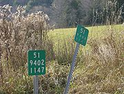
United States – New York
New York reference markers are plates 252 mm by 200 mm (10 by 8 in approx) that have three rows of numbers. Since the lettering is small (60 mm, 2.4 in), they are designed for use by highway engineers rather than motorists. The first row displays the route number, the second row the NYSDOTNew York State Department of Transportation
The New York State Department of Transportation is responsible for the development and operation of highways, railroads, mass transit systems, ports, waterways and aviation facilities in the U.S...
Region, and the third row the control segment and distance from the segment start. The control segment has one digit while the distance from the start of the segment has three digits and is given in units of tenths of a mile.
India
- National Highway 58National Highway 58 (India)National Highway 58 is a National Highway in Northern India. It links Ghaziabad in Uttar Pradesh with Badrinath in Uttarakhand. This Highway passes through Badrinath, Joshimath, Chamoli, Nandaprayag, Rudraprayag, Srinagar, Devprayag, Rishikesh, Haridwar, Muzaffarnagar, Purquazi, Meerut,...
- 180 kilometres from the start of the highway (in DelhiDelhiDelhi , officially National Capital Territory of Delhi , is the largest metropolis by area and the second-largest by population in India, next to Mumbai. It is the eighth largest metropolis in the world by population with 16,753,265 inhabitants in the Territory at the 2011 Census...
) - 24 kilometres to the next big city - HaridwarHaridwarHaridwar is an important pilgrimage city and municipality in the Haridwar district of Uttarakhand, India...
- 352 kilometres to the last town on the route - Mana, IndiaMana, IndiaMana is a village in the district of Chamoli in the Indian state of Uttarakhand. It is located on the northern terminus of National Route 58, Mana is the last village before the Mana Pass and is 24 kilometres from the border of India and Tibet/China. It has about 180 households and a population of...
(which is close to Mana PassMana PassMana Pass , alternatively as Māna La, Chirbitya, Chirbitya-la, or Dungri La is a mountain pass in the Himalayas between India and Tibet...
on the TibetanTibetTibet is a plateau region in Asia, north-east of the Himalayas. It is the traditional homeland of the Tibetan people as well as some other ethnic groups such as Monpas, Qiang, and Lhobas, and is now also inhabited by considerable numbers of Han and Hui people...
/ChineseChinaChinese civilization may refer to:* China for more general discussion of the country.* Chinese culture* Greater China, the transnational community of ethnic Chinese.* History of China* Sinosphere, the area historically affected by Chinese culture...
border, the terminus of the route).
Although the sign illustrated uses Latin script, a number of Indian location markers use the Indian national language Hindi
Hindi
Standard Hindi, or more precisely Modern Standard Hindi, also known as Manak Hindi , High Hindi, Nagari Hindi, and Literary Hindi, is a standardized and sanskritized register of the Hindustani language derived from the Khariboli dialect of Delhi...
.