
High Knob
Encyclopedia
High Knob is the peak of Stone Mountain, and is part of a large mountain, or massif
, in Wise County
, Virginia
near the city of Norton
that rises to 4,223 feet ( 1,287 meters ) above mean sea level.
, along the mountainous southeastern edge of the Cumberland Plateau
of southwestern Virginia. It's massif is unique to Virginia in containing both Appalachian Plateau
and Ridge and Valley
topography; although, it is largely a karstic landform of the Ridge and Valley Province.
The High Knob Massif stretches across portions of southern Wise County, northern Scott County
, and the northeastern tip of Lee County
. It is one of the most significant physical features in Virginia and is among the widest singular mountains in the southern Appalachians, being locally greater than 13 miles ( 21 km ) wide from base to base and more than 26 miles (42 km) long. From the perspective of a singular mountain the High Knob mass is very large and can be said to represent a small massif, being today a remnant of a much greater mountain mass that once filled a large portion of the geologically celebrated upon which it rests (first described in notable detail during the 1920s and 1930s by geologists Charles Butts and John Rich
).
Although some 1,000 to 1,500 feet (300 to 450 m) lower in elevation than the famed Mount Rogers
highcountry (Mount Rogers is the highest peak in Virginia), the terrain surrounding the High Knob of Stone Mountain forms a true highcountry with respect to the western slopes of the Appalachians in Virginia (i.e., the Cumberland Mountains
).
The HKL forms one of the greatest natural areas in the eastern United States. Today its calcareous heart has been breached by massive erosion to expose an ecologically renowned karst landscape which stretches from the subterranean wilderness of its remnant massif, and the Powell Valley
of Wise County, southwest across the Powell River Valley
of Lee County to the Norris Lake
of Tennessee. Drainage from the High Knob Massif has also formed hydrologically complex conduit systems which have directly led to formation of the magnificent Natural Tunnel
and Rye Cove Karst Basin of Scott County, where endemic species such as the Rye Cove Isopod are found.
Included amid these amazing karst valleys of the HKL are such renowned features as The Cedars Natural Area Preserve
and The Unthanks Cave Natural Area Preserve. The Cedars contain a unique
flatrock-type of calcareous terrain that is home to at least 33 rare species of flora and fauna, such as the federally endangered Lee County Cave Isopod, and is considered to be one of the most significant natural areas in the southern Appalachians. The limestone barrens and glades of The Cedars are underlain
by a complex subterranean drainage system that spreads outward to greatly enhance the ecological richness of the Powell River, and to join other renowned systems such as Unthanks Cave, one of the most biologically significant cave systems in Virginia and the southern Appalachians.
Standing boldly above this vast karst landscape are the rugged flanks of the HKL, which extend southwestward from the highcountry of its remnant massif to hold such incredible features as
Cumberland Gap National Historical Park
(NHP), Cave Springs Wilderness Area, Roaring Branch Gorge, and Flag Rock Recreation Area.
The northwestern arm of the HKL can be traced from Pickem Mountain, above the city of Norton
and High Knob Massif, southwest to beyond Cumberland Gap NHP. It is only broken by water level gaps at Big Stone Gap
and Pennington Gap
before reaching Cumberland Gap NHP, with the wind gap of Little Stone Mountain near Norton featuring the scenic Powell Valley
Overlook and passage of U.S. 23
(i.e., the Country Music Highway). The most famous gap of all within the northwestern arm of the HKL is historic Cumberland Gap
.
The northwestern mountain arm of the HKL contains some of the most rugged terrain in the Appalachians, associated with highly overturned rock stratas, with the "White Rocks" of Cumberland Gap NHP being one of the more infamous sections. The Grindstone Ridge Dome, towering above the head of Powell Valley
in Wise County, looks downward upon the northwestern arm (across the Valley) and features a 2,000 foot (610 meters) vertical drop within only 0.8 mile (among the greatest short-distance plunges in Virginia and the southern Appalachians).
The southeastern arm of the HKL is separated from its remnant massif of High Knob by the North Fork of the Clinch River Gap, between Duffield
and Jasper, and stretches southwest as Powell Mountain and Powell Mountain-Newman Ridge into Tennessee. The southeastern arm of the HKL, and much of the remnant massif of its highcountry, acts to greatly enhance the flow volume and diversity of the ecologically renowned Clinch River
.
near its confluence with the mainstem of the Big Stony Basin of High Knob. The Big Stony Basin is a 42-square mile (108.8 km2) multi-gorge wonder, with a vertical elevation range of nearly 3,000 feet (915 meters).
The HKL is essentially the geological equivalent of the Powell Valley Anticline of the Cumberland Mountain Overthrust Block, and is its most dominant structural feature. With its adjoining faults (Hunter Valley-Clinchport system), this region possesses the greatest concentration of significant caves in Virginia.
The High Knob Massif of the HKL, in particular, exerts a significant impact upon the climate of southwestern Virginia and surrounding areas, being one of the rainiest and snowiest locations in both Virginia and the southern Appalachians. It helps generate an atypical decrease in precipitation upon traveling up-basin in the Clinch River Valley, via moisture extraction leeward of its windward slopes and crests, which makes the head of the Clinch River Basin much drier than locations within, and downstream of, the High Knob Massif.
This orographically forced climate has, through the vastness of time, worked in intimate union with the geology and topography to create a richly diverse landscape possessing vast biological diversity.
The renowned biodiversity of the Clinch River Valley.
The High Knob Massif unofficially holds the record for the most snow ever measured in Virginia during a single season, with 200.5 inches (509 cm) during the 1995–96 winter.
During a typical year, 60.0 inches to 70.0 inches (152.4 cm to 178.0 cm) of total precipitation falls across the massif, to make it one of the wettest areas north of the Great Smokies
, and the wettest in Virginia for which there are available records. Significant additional moisture contributions occur from fog drip
off trees and rime
deposition on trees, with many days during the year being spent amid orographic
feeder clouds that cap its upper elevations.
The High Knob Massif contains numerous bogs & wetlands, as well as seven mid-upper elevation man-made water bodies (when including its northwestern arm segment called Little Stone Mountain), ranging
in elevation between 2,360 feet and 3,490 feet (720 to 1,064 m) above mean sea level.
It is the only known mountain in the southern Appalachians with so many bodies of water upon its crest, and the only mountain in which one can drive by five different lakes and never drop below 3,000 feet (915 m) above mean sea level until either the very end or beginning of the journey (depending upon the starting point). Many more lakes, including the great Norris Lake
, are contained within the complete expanse of the HKL.
A large number of mid-upper elevation basins hold all these lakes and wetlands, which acts to separate the High Knob Massif from other mountains within the southern Appalachians (again, a function of its atypically large base-to-base widths, and sprawling crestal surface).
A few of the more notable basins within the core of the massif include: High Knob Lake Basin, Benges Basin, Big Cherry Basin, Glady Fork Basin, and Bark Camp Basin.
The High Knob Massif contains one of the greatest concentrations of mountain gorges in Virginia, with many being associated with a complex duplex
imbricate system that topographically possesses an atypically long back-slope. The longest back-slope on any mountain in western Virginia.
The High Knob Massif contains one of the greatest concentrations of extreme whitewater creeks of any single mountain in the eastern United States, arising from its high concentration of gorges,
with such notable American Whitewater rated runs as:
many other extreme to super-extreme micro-creek runs such as the Jasper Creek Narrows of Dry Fork Gorge.
Rugged extreme creeks, and micro-creeks, draining the immense Straight Fork Gorge and Chimney Rock Fork Gorge have not yet even been run or rated. Many more are candidates.
The High Knob peak is located just beyond the northern end of Powell Mountain
, which is also part of the High Knob Massif and HKL.
The High Knob Massif forms a core area of the Clinch Valley Bioreserve, a 2,200 square mile (5,700 km²) section of southwestern Virginia and upper east Tennessee
that has been designated by the Nature Conservancy as one of the Last Great Places in the World.
The HKL is a national biodiversity
hotspot, with the HKL and its remnant massif of High Knob forming the center of rarity and richness of limited range species in the continental United States,
as designated by Precious Heritage: The Status of Biodiversity in the United States.
On a clear day, four other states can be seen from the summit: West Virginia
, Tennessee
, Kentucky
, and North Carolina
.
, the original structure was a 14' × 14' wooden house. The most recent three-story structure was built by the Flatwoods Job Corps
in 1978–79. High Knob's fire tower is listed in the National Historic Lookout Registry.
On October 31, 2007, the High Knob Lookout Tower was destroyed by arson
. The tower was set on fire in the early hours of Halloween
morning. By the time the Jefferson Forest Service and local fire departments arrived on scene, the fire tower was fully engulfed in flames, and could not be saved. Firefighters were able to keep the fire from spreading to the rest of the Knob, which was suffering from drought conditions.
For more information about the High Knob Landform (HKL), to read about current climate and biodiversity topics, or to contact the biologist and climate researcher behind this project, please reference High Knob Landform.
Massif
In geology, a massif is a section of a planet's crust that is demarcated by faults or flexures. In the movement of the crust, a massif tends to retain its internal structure while being displaced as a whole...
, in Wise County
Wise County, Virginia
Wise County is a county located in the U.S. state of Virginia. In 1856, the county was formed from land taken from Lee, Scott, and Russell Counties. It was named after Henry A. Wise, who was the Governor of Virginia at the time. As of 2010, the population was 41,452, making it the largest...
, Virginia
Virginia
The Commonwealth of Virginia , is a U.S. state on the Atlantic Coast of the Southern United States. Virginia is nicknamed the "Old Dominion" and sometimes the "Mother of Presidents" after the eight U.S. presidents born there...
near the city of Norton
Norton, Virginia
Norton is an independent city within the confines of Wise County in the Commonwealth of Virginia. As of the 2010 Census, the city population was 3,958, making it the smallest city in the state by population...
that rises to 4,223 feet ( 1,287 meters ) above mean sea level.
Location
High Knob is found on the western front range of the Appalachian MountainsAppalachian Mountains
The Appalachian Mountains #Whether the stressed vowel is or ,#Whether the "ch" is pronounced as a fricative or an affricate , and#Whether the final vowel is the monophthong or the diphthong .), often called the Appalachians, are a system of mountains in eastern North America. The Appalachians...
, along the mountainous southeastern edge of the Cumberland Plateau
Cumberland Plateau
The Cumberland Plateau is the southern part of the Appalachian Plateau. It includes much of eastern Kentucky and western West Virginia, part of Tennessee, and a small portion of northern Alabama and northwest Georgia . The terms "Allegheny Plateau" and the "Cumberland Plateau" both refer to the...
of southwestern Virginia. It's massif is unique to Virginia in containing both Appalachian Plateau
Appalachian Plateau
The Appalachian Plateau is the western part of the Appalachian mountains, stretching from New York and Alabama. The plateau is a second level United States physiographic region....
and Ridge and Valley
Ridge-and-valley Appalachians
The Ridge-and-Valley Appalachians, also called the Ridge and Valley Province or the Valley and Ridge Appalachians, are a physiographic province of the larger Appalachian division and are also a belt within the Appalachian Mountains extending from southeastern New York through northwestern New...
topography; although, it is largely a karstic landform of the Ridge and Valley Province.
The High Knob Massif stretches across portions of southern Wise County, northern Scott County
Scott County, Virginia
As of the census of 2000, there were 23,403 people, 9,795 households, and 7,023 families residing in the county. The population density was 44 people per square mile . There were 11,355 housing units at an average density of 21 per square mile...
, and the northeastern tip of Lee County
Lee County, Virginia
According to the census 2009 estimates, there were 25001 people, 11,587 households, and 6,852 families residing in the county. The population density was 54 people per square mile . There were 11,587 housing units at an average density of 25 per square mile...
. It is one of the most significant physical features in Virginia and is among the widest singular mountains in the southern Appalachians, being locally greater than 13 miles ( 21 km ) wide from base to base and more than 26 miles (42 km) long. From the perspective of a singular mountain the High Knob mass is very large and can be said to represent a small massif, being today a remnant of a much greater mountain mass that once filled a large portion of the geologically celebrated upon which it rests (first described in notable detail during the 1920s and 1930s by geologists Charles Butts and John Rich
John Rich
John Rich may refer to:* John Tyler Rich, US Congressman* John Rich , television and film director* John Rich , American musician* John Rich , 18th century theater manager and father of English Pantomime...
).
Although some 1,000 to 1,500 feet (300 to 450 m) lower in elevation than the famed Mount Rogers
Mount Rogers
Mount Rogers is the highest natural point in the state of Virginia, USA, with a summit elevation of above mean sea level. It lies in Grayson County and Smyth County, Virginia, about WSW of Troutdale, Virginia, within the Mount Rogers National Recreation Area and Jefferson National Forest.The...
highcountry (Mount Rogers is the highest peak in Virginia), the terrain surrounding the High Knob of Stone Mountain forms a true highcountry with respect to the western slopes of the Appalachians in Virginia (i.e., the Cumberland Mountains
Cumberland Mountains
The Cumberland Mountains are a mountain range in the southeastern section of the Appalachian Mountains. They are located in southern West Virginia, western Virginia, eastern edges of Kentucky, and eastern middle Tennessee, including the Crab Orchard Mountains...
).
Geology
The High Knob peak caps the High Knob Landform (HKL), which collectively contains the remnant massif of its highcountry (between the Duffield Valley and Guest River Gorge), as well as the extended landform of its ancient domain.The HKL forms one of the greatest natural areas in the eastern United States. Today its calcareous heart has been breached by massive erosion to expose an ecologically renowned karst landscape which stretches from the subterranean wilderness of its remnant massif, and the Powell Valley
Powell Valley
Powell Valley in southwest Virginia, in the United States, is located near the city of Norton and the town of Big Stone Gap in Wise County, Virginia....
of Wise County, southwest across the Powell River Valley
Powell River (Virginia)
The Powell River in the United States rises in southwest Virginia and flows into East Tennessee.The river rises in rural Wise County, Virginia near the Laurel Grove community northwest of Norton and flows for several miles before the confluence with Roaring Fork in the Kent Junction community...
of Lee County to the Norris Lake
Norris Dam
Norris Dam is a hydroelectric and flood control structure located on the Clinch River in Anderson County and Campbell County, Tennessee, USA. Its construction in the mid-1930s was the first major project for the Tennessee Valley Authority, which had been created in 1933 to bring economic...
of Tennessee. Drainage from the High Knob Massif has also formed hydrologically complex conduit systems which have directly led to formation of the magnificent Natural Tunnel
Natural Tunnel State Park
Natural Tunnel State Park is a Virginia state park, centered around the Natural Tunnel, a massive naturally formed cave that is so large it is used as a railroad tunnel...
and Rye Cove Karst Basin of Scott County, where endemic species such as the Rye Cove Isopod are found.
Included amid these amazing karst valleys of the HKL are such renowned features as The Cedars Natural Area Preserve
The Cedars Natural Area Preserve
The Cedars Natural Area Preserve is a Natural Area Preserve located in Lee County, Virginia. It derives its name from The Cedars, the karst region near the Powell River in which it is located. It supports a community of limestone glades and woodlands over limestone bedrock, and much of the...
and The Unthanks Cave Natural Area Preserve. The Cedars contain a unique
flatrock-type of calcareous terrain that is home to at least 33 rare species of flora and fauna, such as the federally endangered Lee County Cave Isopod, and is considered to be one of the most significant natural areas in the southern Appalachians. The limestone barrens and glades of The Cedars are underlain
by a complex subterranean drainage system that spreads outward to greatly enhance the ecological richness of the Powell River, and to join other renowned systems such as Unthanks Cave, one of the most biologically significant cave systems in Virginia and the southern Appalachians.
Standing boldly above this vast karst landscape are the rugged flanks of the HKL, which extend southwestward from the highcountry of its remnant massif to hold such incredible features as
Cumberland Gap National Historical Park
Cumberland Gap National Historical Park
Established on June 11, 1940, Cumberland Gap National Historical Park is a United States National Historical Park located at the border between Kentucky, Tennessee, and Virginia. The Cumberland Gap is a sizable natural break in the Appalachian Mountains....
(NHP), Cave Springs Wilderness Area, Roaring Branch Gorge, and Flag Rock Recreation Area.
The northwestern arm of the HKL can be traced from Pickem Mountain, above the city of Norton
Norton, Virginia
Norton is an independent city within the confines of Wise County in the Commonwealth of Virginia. As of the 2010 Census, the city population was 3,958, making it the smallest city in the state by population...
and High Knob Massif, southwest to beyond Cumberland Gap NHP. It is only broken by water level gaps at Big Stone Gap
Big Stone Gap, Virginia
Big Stone Gap is a town in Wise County, Virginia, United States. The population was 5,643 at the 2010 census.-History:The community was formerly known as "Meneral City" and "Three Forks." The "Big Stone Gap" refers to the valley which has been created on the Appalachia Straight, located between...
and Pennington Gap
Pennington Gap, Virginia
Pennington Gap is the most populous town in Lee County, Virginia, United States. The population was 1,781 at the 2000 census.The Lee Regional Medical Center is in Pennington Gap, and the United States Penitentiary, Lee is nearby.-Geography:...
before reaching Cumberland Gap NHP, with the wind gap of Little Stone Mountain near Norton featuring the scenic Powell Valley
Powell Valley
Powell Valley in southwest Virginia, in the United States, is located near the city of Norton and the town of Big Stone Gap in Wise County, Virginia....
Overlook and passage of U.S. 23
U.S. Route 23 in Virginia
U.S. Route 23 is a part of the U.S. Highway System that runs from Jacksonville, Florida to Mackinaw City, Michigan. In Virginia, the U.S. Highway runs from the Tennessee state line near Weber City north to the Kentucky state line near Pound...
(i.e., the Country Music Highway). The most famous gap of all within the northwestern arm of the HKL is historic Cumberland Gap
Cumberland Gap
Cumberland Gap is a pass through the Cumberland Mountains region of the Appalachian Mountains, also known as the Cumberland Water Gap, at the juncture of the U.S. states of Tennessee, Kentucky, and Virginia...
.
The northwestern mountain arm of the HKL contains some of the most rugged terrain in the Appalachians, associated with highly overturned rock stratas, with the "White Rocks" of Cumberland Gap NHP being one of the more infamous sections. The Grindstone Ridge Dome, towering above the head of Powell Valley
Powell Valley
Powell Valley in southwest Virginia, in the United States, is located near the city of Norton and the town of Big Stone Gap in Wise County, Virginia....
in Wise County, looks downward upon the northwestern arm (across the Valley) and features a 2,000 foot (610 meters) vertical drop within only 0.8 mile (among the greatest short-distance plunges in Virginia and the southern Appalachians).
The southeastern arm of the HKL is separated from its remnant massif of High Knob by the North Fork of the Clinch River Gap, between Duffield
Duffield, Virginia
Duffield is a town in Scott County, Virginia, United States. The population was 91 at the 2010 census. It is part of the Kingsport–Bristol –Bristol Metropolitan Statistical Area, which is a component of the Johnson City–Kingsport–Bristol, TN-VA Combined Statistical Area – commonly known as...
and Jasper, and stretches southwest as Powell Mountain and Powell Mountain-Newman Ridge into Tennessee. The southeastern arm of the HKL, and much of the remnant massif of its highcountry, acts to greatly enhance the flow volume and diversity of the ecologically renowned Clinch River
Clinch River
The Clinch River rises in Southwest Virginia near Tazewell, Virginia and flows southwest through the Great Appalachian Valley, gathering various tributaries including the Powell River before joining the Tennessee River in East Tennessee.-Course:...
.
Features
The Nature Conservancy's Pendleton Island Preserve is located on the Clinch RiverClinch River
The Clinch River rises in Southwest Virginia near Tazewell, Virginia and flows southwest through the Great Appalachian Valley, gathering various tributaries including the Powell River before joining the Tennessee River in East Tennessee.-Course:...
near its confluence with the mainstem of the Big Stony Basin of High Knob. The Big Stony Basin is a 42-square mile (108.8 km2) multi-gorge wonder, with a vertical elevation range of nearly 3,000 feet (915 meters).
The HKL is essentially the geological equivalent of the Powell Valley Anticline of the Cumberland Mountain Overthrust Block, and is its most dominant structural feature. With its adjoining faults (Hunter Valley-Clinchport system), this region possesses the greatest concentration of significant caves in Virginia.
The High Knob Massif of the HKL, in particular, exerts a significant impact upon the climate of southwestern Virginia and surrounding areas, being one of the rainiest and snowiest locations in both Virginia and the southern Appalachians. It helps generate an atypical decrease in precipitation upon traveling up-basin in the Clinch River Valley, via moisture extraction leeward of its windward slopes and crests, which makes the head of the Clinch River Basin much drier than locations within, and downstream of, the High Knob Massif.
This orographically forced climate has, through the vastness of time, worked in intimate union with the geology and topography to create a richly diverse landscape possessing vast biological diversity.
The renowned biodiversity of the Clinch River Valley.
The High Knob Massif unofficially holds the record for the most snow ever measured in Virginia during a single season, with 200.5 inches (509 cm) during the 1995–96 winter.
During a typical year, 60.0 inches to 70.0 inches (152.4 cm to 178.0 cm) of total precipitation falls across the massif, to make it one of the wettest areas north of the Great Smokies
Great Smoky Mountains
The Great Smoky Mountains are a mountain range rising along the Tennessee–North Carolina border in the southeastern United States. They are a subrange of the Appalachian Mountains, and form part of the Blue Ridge Physiographic Province. The range is sometimes called the Smoky Mountains or the...
, and the wettest in Virginia for which there are available records. Significant additional moisture contributions occur from fog drip
Fog drip
Fog drip is a type of precipitation that forms when fog droplets condense on the needles or leaves of trees or other objects, and drips to the ground....
off trees and rime
Rime
Rime is a coating of ice:*Hard rime, white ice that forms when water droplets in fog freeze to the outer surfaces of objects, such as trees*Soft rime, similar to hard rime, but feathery and milky in appearance...
deposition on trees, with many days during the year being spent amid orographic
Orographic lift
Orographic lift occurs when an air mass is forced from a low elevation to a higher elevation as it moves over rising terrain. As the air mass gains altitude it quickly cools down adiabatically, which can raise the relative humidity to 100% and create clouds and, under the right conditions,...
feeder clouds that cap its upper elevations.
The High Knob Massif contains numerous bogs & wetlands, as well as seven mid-upper elevation man-made water bodies (when including its northwestern arm segment called Little Stone Mountain), ranging
in elevation between 2,360 feet and 3,490 feet (720 to 1,064 m) above mean sea level.
It is the only known mountain in the southern Appalachians with so many bodies of water upon its crest, and the only mountain in which one can drive by five different lakes and never drop below 3,000 feet (915 m) above mean sea level until either the very end or beginning of the journey (depending upon the starting point). Many more lakes, including the great Norris Lake
Norris Lake
Norris Lake may refer to:* Norris Lake, a Tennessee Valley Authority reservoir in Tennessee, impounded by Norris Dam* Lake Norris in Lake County, Florida...
, are contained within the complete expanse of the HKL.
A large number of mid-upper elevation basins hold all these lakes and wetlands, which acts to separate the High Knob Massif from other mountains within the southern Appalachians (again, a function of its atypically large base-to-base widths, and sprawling crestal surface).
A few of the more notable basins within the core of the massif include: High Knob Lake Basin, Benges Basin, Big Cherry Basin, Glady Fork Basin, and Bark Camp Basin.
The High Knob Massif contains one of the greatest concentrations of mountain gorges in Virginia, with many being associated with a complex duplex
Thrust fault
A thrust fault is a type of fault, or break in the Earth's crust across which there has been relative movement, in which rocks of lower stratigraphic position are pushed up and over higher strata. They are often recognized because they place older rocks above younger...
imbricate system that topographically possesses an atypically long back-slope. The longest back-slope on any mountain in western Virginia.
The High Knob Massif contains one of the greatest concentrations of extreme whitewater creeks of any single mountain in the eastern United States, arising from its high concentration of gorges,
with such notable American Whitewater rated runs as:
- Little Stony Gorge,
- South Fork Gorge,
- Mountain Fork of Big Stony Gorge,
- Guest River Gorge, and
many other extreme to super-extreme micro-creek runs such as the Jasper Creek Narrows of Dry Fork Gorge.
Rugged extreme creeks, and micro-creeks, draining the immense Straight Fork Gorge and Chimney Rock Fork Gorge have not yet even been run or rated. Many more are candidates.
The High Knob peak is located just beyond the northern end of Powell Mountain
Powell Mountain (Virginia)
Powell Mountain is a mountain ridge of the Ridge-and-valley Appalachians of the Appalachian Mountains. It is a long and narrow ridge, running northeast to southwest, from about Norton, Virginia to near Tazewell, Tennessee...
, which is also part of the High Knob Massif and HKL.
The High Knob Massif forms a core area of the Clinch Valley Bioreserve, a 2,200 square mile (5,700 km²) section of southwestern Virginia and upper east Tennessee
Tennessee
Tennessee is a U.S. state located in the Southeastern United States. It has a population of 6,346,105, making it the nation's 17th-largest state by population, and covers , making it the 36th-largest by total land area...
that has been designated by the Nature Conservancy as one of the Last Great Places in the World.
The HKL is a national biodiversity
Biodiversity
Biodiversity is the degree of variation of life forms within a given ecosystem, biome, or an entire planet. Biodiversity is a measure of the health of ecosystems. Biodiversity is in part a function of climate. In terrestrial habitats, tropical regions are typically rich whereas polar regions...
hotspot, with the HKL and its remnant massif of High Knob forming the center of rarity and richness of limited range species in the continental United States,
as designated by Precious Heritage: The Status of Biodiversity in the United States.
On a clear day, four other states can be seen from the summit: West Virginia
West Virginia
West Virginia is a state in the Appalachian and Southeastern regions of the United States, bordered by Virginia to the southeast, Kentucky to the southwest, Ohio to the northwest, Pennsylvania to the northeast and Maryland to the east...
, Tennessee
Tennessee
Tennessee is a U.S. state located in the Southeastern United States. It has a population of 6,346,105, making it the nation's 17th-largest state by population, and covers , making it the 36th-largest by total land area...
, Kentucky
Kentucky
The Commonwealth of Kentucky is a state located in the East Central United States of America. As classified by the United States Census Bureau, Kentucky is a Southern state, more specifically in the East South Central region. Kentucky is one of four U.S. states constituted as a commonwealth...
, and North Carolina
North Carolina
North Carolina is a state located in the southeastern United States. The state borders South Carolina and Georgia to the south, Tennessee to the west and Virginia to the north. North Carolina contains 100 counties. Its capital is Raleigh, and its largest city is Charlotte...
.
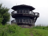
High Knob Lookout Tower
At its peak stood one of the few remaining fire towers of the Appalachian Mountains. Built in 1938–39 by the Civilian Conservation CorpsCivilian Conservation Corps
The Civilian Conservation Corps was a public work relief program that operated from 1933 to 1942 in the United States for unemployed, unmarried men from relief families, ages 18–25. A part of the New Deal of President Franklin D...
, the original structure was a 14' × 14' wooden house. The most recent three-story structure was built by the Flatwoods Job Corps
Job Corps
Job Corps is a program administered by the United States Department of Labor that offers free-of-charge education and vocational training to youth ages 16 to 24.-Mission and purpose:...
in 1978–79. High Knob's fire tower is listed in the National Historic Lookout Registry.
On October 31, 2007, the High Knob Lookout Tower was destroyed by arson
Arson
Arson is the crime of intentionally or maliciously setting fire to structures or wildland areas. It may be distinguished from other causes such as spontaneous combustion and natural wildfires...
. The tower was set on fire in the early hours of Halloween
Halloween
Hallowe'en , also known as Halloween or All Hallows' Eve, is a yearly holiday observed around the world on October 31, the night before All Saints' Day...
morning. By the time the Jefferson Forest Service and local fire departments arrived on scene, the fire tower was fully engulfed in flames, and could not be saved. Firefighters were able to keep the fire from spreading to the rest of the Knob, which was suffering from drought conditions.
Mountain information
For more information about High Knob, current events, and important news, please reference The Clinch Coalition, link below.For more information about the High Knob Landform (HKL), to read about current climate and biodiversity topics, or to contact the biologist and climate researcher behind this project, please reference High Knob Landform.
External links
- Clinch Coalition
-
- www.timesnews.net has a Google Advisory for being a malicious website ***
-