
Mount Rogers
Encyclopedia
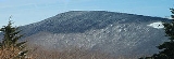
Mount Rogers is the highest natural point in the state of Virginia
, USA
, with a summit elevation of 5729 feet (1,746.2 m) above mean sea level. It lies in Grayson County
and Smyth County, Virginia, about 6.45 miles (10.4 km) WSW of Troutdale, Virginia
, within the Mount Rogers National Recreation Area
and Jefferson National Forest.
The mountain is named for William Barton Rogers
, a Virginian educated at the College of William & Mary, who taught at William & Mary and the University of Virginia
, became Virginia's first State Geologist, and went on to found the Massachusetts Institute of Technology
.
The summit is most easily accessed from Grayson Highlands State Park
by following the Appalachian Trail
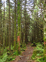
southbound for 3.5 miles (5.6 km) to a blue-blazed trail leading to the summit, which is covered by trees and marked with four National Geodetic Survey triangulation station disk
s; a standard station disk marked with an equilateral triangle and three standard reference disks marked with arrows pointing towards the station disk. One reference disk has been obscured by dense overgrowth. Because the Appalachian Trail passes within a half mile of the summit, the area is especially popular with hikers.
es were part of the landscape. Roughly 750 million years ago, rift
-related (divergent) volcanoes erupted along the axis of what later became the Appalachians, and one remnant of that volcanic zone, with its volcanic rock
s, still can be seen at Mount Rogers. Massive rhyolite
lava
flows erupted at the mountain during the Precambrian
rifting event. Mount Rogers is also the only place in Virginia that preserves evidence of ancient Proterozoic
glaciation.
 Mount Rogers is the northernmost habitat of the high-altitude Southern Appalachian spruce-fir forest
s, which are found in only five other locations in the United States: the Great Smoky Mountains
, the Black Mountains
, the Great Balsam Mountains
, Grandfather Mountain
, and Roan Mountain
. This forest type is one of the few remaining habitats of the Fraser fir, which is only found at high elevations, typically above 5500 feet (1,676.4 m), in the southern Appalachian Mountains.
These forests have suffered recent declines due to infestations by the balsam woolly adelgid (Adelges piceae), a non-native insect that originated in Europe. It first infested Mount Rogers in 1962 and the entire U.S. population of Fraser firs suffered a 67% mortality rate since, although Mount Rogers was not affected as severely as other locations.
Some researchers have proposed that air pollution in the form of nitrogen and sulfur compounds originating from power plants has been a source of stress to the Fraser firs, resulting in an increased susceptibility to the balsam woolly adelgid, but this relationship has not been confirmed.
Virginia
The Commonwealth of Virginia , is a U.S. state on the Atlantic Coast of the Southern United States. Virginia is nicknamed the "Old Dominion" and sometimes the "Mother of Presidents" after the eight U.S. presidents born there...
, USA
United States
The United States of America is a federal constitutional republic comprising fifty states and a federal district...
, with a summit elevation of 5729 feet (1,746.2 m) above mean sea level. It lies in Grayson County
Grayson County, Virginia
As of the census of 2000, there were 17,917 people, 7,259 households, and 5,088 families residing in the county. The population density was 40 people per square mile . There were 9,123 housing units at an average density of 21 per square mile...
and Smyth County, Virginia, about 6.45 miles (10.4 km) WSW of Troutdale, Virginia
Troutdale, Virginia
Troutdale is a town in Grayson County, Virginia, United States. The population was 194 at the 2000 census.-Geography:Troutdale is located at ....
, within the Mount Rogers National Recreation Area
Mount Rogers National Recreation Area
Mount Rogers National Recreation Area is a United States National Recreation Area located in southwestern Virginia near the border with Tennessee and North Carolina. The centerpiece of the recreation area is Mount Rogers, the highest point in the state of Virginia with a summit elevation of 5,729...
and Jefferson National Forest.
The mountain is named for William Barton Rogers
William Barton Rogers
William Barton Rogers was a geologist, physicist and educator. He is best known for setting down the founding principles for, advocating for, and finally obtaining the incorporation of the Massachusetts Institute of Technology in 1861...
, a Virginian educated at the College of William & Mary, who taught at William & Mary and the University of Virginia
University of Virginia
The University of Virginia is a public research university located in Charlottesville, Virginia, United States, founded by Thomas Jefferson...
, became Virginia's first State Geologist, and went on to found the Massachusetts Institute of Technology
Massachusetts Institute of Technology
The Massachusetts Institute of Technology is a private research university located in Cambridge, Massachusetts. MIT has five schools and one college, containing a total of 32 academic departments, with a strong emphasis on scientific and technological education and research.Founded in 1861 in...
.
The summit is most easily accessed from Grayson Highlands State Park
Grayson Highlands State Park
Grayson Highlands State Park is located in Virginia, United States, adjacent to Mount Rogers National Recreation Area. The park lies within Jefferson National Forest. The park was established in 1965 and contains a total of 4,822 acres...
by following the Appalachian Trail
Appalachian Trail
The Appalachian National Scenic Trail, generally known as the Appalachian Trail or simply the AT, is a marked hiking trail in the eastern United States extending between Springer Mountain in Georgia and Mount Katahdin in Maine. It is approximately long...
southbound for 3.5 miles (5.6 km) to a blue-blazed trail leading to the summit, which is covered by trees and marked with four National Geodetic Survey triangulation station disk
Benchmark (surveying)
The term bench mark, or benchmark, originates from the chiseled horizontal marks that surveyors made in stone structures, into which an angle-iron could be placed to form a "bench" for a leveling rod, thus ensuring that a leveling rod could be accurately repositioned in the same place in the future...
s; a standard station disk marked with an equilateral triangle and three standard reference disks marked with arrows pointing towards the station disk. One reference disk has been obscured by dense overgrowth. Because the Appalachian Trail passes within a half mile of the summit, the area is especially popular with hikers.
Geology
The Mount Rogers area contains a unique record of the geohistory of Virginia. There is evidence from the rocks that volcanoVolcano
2. Bedrock3. Conduit 4. Base5. Sill6. Dike7. Layers of ash emitted by the volcano8. Flank| 9. Layers of lava emitted by the volcano10. Throat11. Parasitic cone12. Lava flow13. Vent14. Crater15...
es were part of the landscape. Roughly 750 million years ago, rift
Rift
In geology, a rift or chasm is a place where the Earth's crust and lithosphere are being pulled apart and is an example of extensional tectonics....
-related (divergent) volcanoes erupted along the axis of what later became the Appalachians, and one remnant of that volcanic zone, with its volcanic rock
Volcanic rock
Volcanic rock is a rock formed from magma erupted from a volcano. In other words, it is an igneous rock of volcanic origin...
s, still can be seen at Mount Rogers. Massive rhyolite
Rhyolite
This page is about a volcanic rock. For the ghost town see Rhyolite, Nevada, and for the satellite system, see Rhyolite/Aquacade.Rhyolite is an igneous, volcanic rock, of felsic composition . It may have any texture from glassy to aphanitic to porphyritic...
lava
Lava
Lava refers both to molten rock expelled by a volcano during an eruption and the resulting rock after solidification and cooling. This molten rock is formed in the interior of some planets, including Earth, and some of their satellites. When first erupted from a volcanic vent, lava is a liquid at...
flows erupted at the mountain during the Precambrian
Precambrian
The Precambrian is the name which describes the large span of time in Earth's history before the current Phanerozoic Eon, and is a Supereon divided into several eons of the geologic time scale...
rifting event. Mount Rogers is also the only place in Virginia that preserves evidence of ancient Proterozoic
Proterozoic
The Proterozoic is a geological eon representing a period before the first abundant complex life on Earth. The name Proterozoic comes from the Greek "earlier life"...
glaciation.
Spruce-fir forests
Southern Appalachian spruce-fir forest
The Southern Appalachian spruce-fir forest is a type of montane coniferous forest that grows in the highest elevations in the southern Appalachian Mountains of the eastern United States...
s, which are found in only five other locations in the United States: the Great Smoky Mountains
Great Smoky Mountains
The Great Smoky Mountains are a mountain range rising along the Tennessee–North Carolina border in the southeastern United States. They are a subrange of the Appalachian Mountains, and form part of the Blue Ridge Physiographic Province. The range is sometimes called the Smoky Mountains or the...
, the Black Mountains
Black Mountains (North Carolina)
The Black Mountains are a mountain range in western North Carolina, in the southeastern United States. They are part of the Blue Ridge Province of the Southern Appalachian Mountains. The Blacks are the highest mountains in the Eastern United States...
, the Great Balsam Mountains
Great Balsam Mountains
The Great Balsam Mountains, or Balsam Mountains, are in the mountain region of western North Carolina, United States. The Great Balsams are a subrange of the Blue Ridge Mountains, which in turn are a part of the Appalachian Mountains...
, Grandfather Mountain
Grandfather Mountain
Grandfather Mountain is a mountain, a non-profit attraction, and a North Carolina state parknear Linville, North Carolina. At 5,946 feet , it is the highest peak on the eastern escarpment of the Blue Ridge Mountains, one of the major chains of the Appalachian Mountains. The Blue Ridge Parkway...
, and Roan Mountain
Roan Mountain (Roan Highlands)
Roan Mountain is the highpoint of the Roan-Unaka Range of the Southern Appalachian Mountains, located in the Southeastern United States. The mountain is clad in a dense stand of Southern Appalachian spruce-fir forest, and includes the world's largest natural rhododendron garden, and the longest...
. This forest type is one of the few remaining habitats of the Fraser fir, which is only found at high elevations, typically above 5500 feet (1,676.4 m), in the southern Appalachian Mountains.
These forests have suffered recent declines due to infestations by the balsam woolly adelgid (Adelges piceae), a non-native insect that originated in Europe. It first infested Mount Rogers in 1962 and the entire U.S. population of Fraser firs suffered a 67% mortality rate since, although Mount Rogers was not affected as severely as other locations.
Some researchers have proposed that air pollution in the form of nitrogen and sulfur compounds originating from power plants has been a source of stress to the Fraser firs, resulting in an increased susceptibility to the balsam woolly adelgid, but this relationship has not been confirmed.
See also
- Mount Rogers National Recreation AreaMount Rogers National Recreation AreaMount Rogers National Recreation Area is a United States National Recreation Area located in southwestern Virginia near the border with Tennessee and North Carolina. The centerpiece of the recreation area is Mount Rogers, the highest point in the state of Virginia with a summit elevation of 5,729...
- Whitetop MountainWhitetop MountainWhitetop Mountain is the second highest mountain in the U.S. state of Virginia, after nearby Mount Rogers. It is located at the juncture of Grayson, Smyth, and Washington Counties in the state of Virginia. Whitetop was the location of the White Top Folk Festival from 1932 to 1939, with the...
- Reddish KnobReddish KnobReddish Knob of Shenandoah Mountain is one of the highest points in Virginia, rising . No other peak rises higher to the northeast before New York's Catskills...
- High KnobHigh KnobHigh Knob is the peak of Stone Mountain, and is part of a large mountain, or massif, in Wise County, Virginia near the city of Norton that rises to 4,223 feet above mean sea level.-Location:...
- List of tallest mountains of U.S. states