
Derwent Edge
Encyclopedia
Derwent Edge is a Millstone Grit
escarpment that lies above the Upper Derwent Valley
in the Peak District
National Park
in the English
county of Derbyshire
. The Millstone Grit
forms the edge of the high peat moorland
plateau on the eastern side of the valley above Ladybower Reservoir
, the edges being the last remains of the gritstone which originally covered all of the Peak District, most of which was scraped off by glaciers in the last ice age
. An Ordnance Survey
column
marks the highest point of the Edge at Back Tor at a height of 538 metres (1765 feet). North of Back Tor the edge extends into Howden Edge
and enters the county of South Yorkshire
.
The Edge itself is notable for its unusual gritstone tors and its views of the Derwent Valley and the Dark Peak
landscape; these features along with its proximity to Sheffield
have made it a popular venue for walkers. Its popularity has led to substantial path erosion and the most affected parts of the edge between The Salt Cellar and Lost Lad Hillend have been paved with natural stone slabs to reduce further damage as part of the Lottery Paths Project.
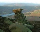
Derwent Edge has several examples of unusually shaped gritstone tors which have been formed by the actions of wind
, rain
and frost
over many centuries. These tors have been named over the years by local residents and have now been officially titled on Ordnance Survey maps. These include the Cakes of Bread, the Coach and Horses and the Salt Cellar. The Coach and Horses (also known as the Wheel Stones and thus named on Ordnance Survey maps) resembles a coach and horses on the horizon when viewed from the A57 road
to the south. Lost Lad Hillend is worth visiting as it has a stone built topographic indicator to aid identifying landmarks in the extensive view.
Derwent Edge is popular with walkers and is described in many walking guides. Mark Richards describes a 10.5 mile walk in his book “High Peak Walks” (ISBN 0-902363-43-3), starting at the Fairholmes car park in the Upper Derwent Valley (Grid Reference ) at the northern end of Ladybower Reservoir; it is also possible to access the edge from Cutthroat Bridge (lay by parking) on the A57 or from Strines Reservoir
car park near the Strines public house. Derwent Edge is popular with rock climbers
and has about 50 different routes ranging from difficult to hard very severe; however, it is not as well used as the nearby Stanage Edge.
Much of the moorland around Derwent Edge has been declared a Site of Special Scientific Interest
(SSSI) because of its special vegetation and rare birds and animals, such as the Eurasian Golden Plover
, Red Grouse
, Ring Ouzel
and Mountain Hare
. Rare species of plants such as Common Cottongrass
, Mountain Strawberry, and Crowberry
grow in the area. It has been proposed as a Special Protection Area
for birds under a European Directive. The edge is part of the National Trust's
High Peak Estate
and visitors are free to roam at will but are urged to keep to established routes to avoid disturbing breeding birds. There are occasional times that the moors are closed for management purposes.
Gritstone
Gritstone or Grit is a hard, coarse-grained, siliceous sandstone. This term is especially applied to such sandstones that are quarried for building material. British gritstone was used for millstones to mill flour, to grind wood into pulp for paper and for grindstones to sharpen blades. "Grit" is...
escarpment that lies above the Upper Derwent Valley
Upper Derwent Valley
The Upper Derwent Valley is an area of the Peak District National Park in England. It largely lies in Derbyshire, but its north eastern area lies in Sheffield, South Yorkshire...
in the Peak District
Peak District
The Peak District is an upland area in central and northern England, lying mainly in northern Derbyshire, but also covering parts of Cheshire, Greater Manchester, Staffordshire, and South and West Yorkshire....
National Park
National park
A national park is a reserve of natural, semi-natural, or developed land that a sovereign state declares or owns. Although individual nations designate their own national parks differently A national park is a reserve of natural, semi-natural, or developed land that a sovereign state declares or...
in the English
England
England is a country that is part of the United Kingdom. It shares land borders with Scotland to the north and Wales to the west; the Irish Sea is to the north west, the Celtic Sea to the south west, with the North Sea to the east and the English Channel to the south separating it from continental...
county of Derbyshire
Derbyshire
Derbyshire is a county in the East Midlands of England. A substantial portion of the Peak District National Park lies within Derbyshire. The northern part of Derbyshire overlaps with the Pennines, a famous chain of hills and mountains. The county contains within its boundary of approx...
. The Millstone Grit
Millstone Grit
Millstone Grit is the name given to any of a number of coarse-grained sandstones of Carboniferous age which occur in the Northern England. The name derives from its use in earlier times as a source of millstones for use principally in watermills...
forms the edge of the high peat moorland
Moorland
Moorland or moor is a type of habitat, in the temperate grasslands, savannas, and shrublands biome, found in upland areas, characterised by low-growing vegetation on acidic soils and heavy fog...
plateau on the eastern side of the valley above Ladybower Reservoir
Ladybower Reservoir
Ladybower Reservoir is a large Y-shaped reservoir, the lowest of three in the Upper Derwent Valley in Derbyshire, England. The River Ashop flows into the reservoir from the west; the River Derwent flows south, initially through Howden Reservoir, then Derwent Reservoir, and finally through Ladybower...
, the edges being the last remains of the gritstone which originally covered all of the Peak District, most of which was scraped off by glaciers in the last ice age
Ice age
An ice age or, more precisely, glacial age, is a generic geological period of long-term reduction in the temperature of the Earth's surface and atmosphere, resulting in the presence or expansion of continental ice sheets, polar ice sheets and alpine glaciers...
. An Ordnance Survey
Ordnance Survey
Ordnance Survey , an executive agency and non-ministerial government department of the Government of the United Kingdom, is the national mapping agency for Great Britain, producing maps of Great Britain , and one of the world's largest producers of maps.The name reflects its creation together with...
column
Trig point
A triangulation station, also known as a triangulation pillar, trigonometrical station, trigonometrical point, trig station, trig beacon or trig point, and sometimes informally as a trig, is a fixed surveying station, used in geodetic surveying and other surveying projects in its vicinity...
marks the highest point of the Edge at Back Tor at a height of 538 metres (1765 feet). North of Back Tor the edge extends into Howden Edge
Howden Edge
Howden Edge is a peak which lies in the north east of the Upper Derwent Valley area of the Peak District National Park in England. At 545 m it is the second highest point in South Yorkshire, after Margery Hill. It is situated to the north east of Howden Reservoir and north of Abbey Brook....
and enters the county of South Yorkshire
South Yorkshire
South Yorkshire is a metropolitan county in the Yorkshire and the Humber region of England. It has a population of 1.29 million. It consists of four metropolitan boroughs: Barnsley, Doncaster, Rotherham, and City of Sheffield...
.
The Edge itself is notable for its unusual gritstone tors and its views of the Derwent Valley and the Dark Peak
Dark Peak
The Dark Peak is the higher, wilder northern part of the Peak District in England.It gets its name because , the underlying limestone is covered by a cap of Millstone Grit which means that in winter the soil is almost always saturated with water...
landscape; these features along with its proximity to Sheffield
Sheffield
Sheffield is a city and metropolitan borough of South Yorkshire, England. Its name derives from the River Sheaf, which runs through the city. Historically a part of the West Riding of Yorkshire, and with some of its southern suburbs annexed from Derbyshire, the city has grown from its largely...
have made it a popular venue for walkers. Its popularity has led to substantial path erosion and the most affected parts of the edge between The Salt Cellar and Lost Lad Hillend have been paved with natural stone slabs to reduce further damage as part of the Lottery Paths Project.
Derwent Edge has several examples of unusually shaped gritstone tors which have been formed by the actions of wind
Wind
Wind is the flow of gases on a large scale. On Earth, wind consists of the bulk movement of air. In outer space, solar wind is the movement of gases or charged particles from the sun through space, while planetary wind is the outgassing of light chemical elements from a planet's atmosphere into space...
, rain
Rain
Rain is liquid precipitation, as opposed to non-liquid kinds of precipitation such as snow, hail and sleet. Rain requires the presence of a thick layer of the atmosphere to have temperatures above the melting point of water near and above the Earth's surface...
and frost
Frost
Frost is the solid deposition of water vapor from saturated air. It is formed when solid surfaces are cooled to below the dew point of the adjacent air as well as below the freezing point of water. Frost crystals' size differ depending on time and water vapour available. Frost is also usually...
over many centuries. These tors have been named over the years by local residents and have now been officially titled on Ordnance Survey maps. These include the Cakes of Bread, the Coach and Horses and the Salt Cellar. The Coach and Horses (also known as the Wheel Stones and thus named on Ordnance Survey maps) resembles a coach and horses on the horizon when viewed from the A57 road
A57 road
The A57 is a major road in England. It runs east from Liverpool to Lincoln, via Warrington, Cadishead, Irlam, Patricroft, Eccles, Salford and Manchester, then through the Pennines over the Snake Pass , around the Ladybower Reservoir, through Sheffield and past Worksop...
to the south. Lost Lad Hillend is worth visiting as it has a stone built topographic indicator to aid identifying landmarks in the extensive view.
Derwent Edge is popular with walkers and is described in many walking guides. Mark Richards describes a 10.5 mile walk in his book “High Peak Walks” (ISBN 0-902363-43-3), starting at the Fairholmes car park in the Upper Derwent Valley (Grid Reference ) at the northern end of Ladybower Reservoir; it is also possible to access the edge from Cutthroat Bridge (lay by parking) on the A57 or from Strines Reservoir
Strines Reservoir
Strines Reservoir is a water storage reservoir situated at , it lies west of the centre of Sheffield in South Yorkshire, England.-Construction:...
car park near the Strines public house. Derwent Edge is popular with rock climbers
Climbing
Climbing is the activity of using one's hands and feet to ascend a steep object. It is done both for recreation and professionally, as part of activities such as maintenance of a structure, or military operations.Climbing activities include:* Bouldering: Ascending boulders or small...
and has about 50 different routes ranging from difficult to hard very severe; however, it is not as well used as the nearby Stanage Edge.
Much of the moorland around Derwent Edge has been declared a Site of Special Scientific Interest
Site of Special Scientific Interest
A Site of Special Scientific Interest is a conservation designation denoting a protected area in the United Kingdom. SSSIs are the basic building block of site-based nature conservation legislation and most other legal nature/geological conservation designations in Great Britain are based upon...
(SSSI) because of its special vegetation and rare birds and animals, such as the Eurasian Golden Plover
Eurasian Golden Plover
The European Golden Plover is a largish plover. This species is similar to two other golden plovers. American Golden Plover, Pluvialis dominiica, and Pacific Golden Plover, Pluvialis fulva, are both smaller, slimmer and relatively longer-legged than European Golden Plover, and both have grey...
, Red Grouse
Red grouse
The Red Grouse is a medium sized bird of the grouse family which is found in heather moorland in Great Britain and Ireland. It is usually classified as a subspecies of the Willow Grouse but is sometimes considered to be a separate species Lagopus scoticus...
, Ring Ouzel
Ring Ouzel
The Ring Ouzel is a European member of the thrush family Turdidae.It is the mountain equivalent of the closely related Common Blackbird, and breeds in gullies, rocky areas or scree slopes....
and Mountain Hare
Mountain Hare
The Mountain Hare , also known as Blue Hare, Tundra Hare, Variable Hare, White Hare, Alpine Hare and Irish Hare, is a hare, which is largely adapted to polar and mountainous habitats. It is distributed from Fennoscandia to eastern Siberia; in addition there are isolated populations in the Alps,...
. Rare species of plants such as Common Cottongrass
Common Cottongrass
Common Cottongrass is a plant from the sedge family, so even though it looks like a form of grass, technically it is not. It grows in acidic wetlands and peat bogs all over northern parts of Europe, Asia and North America...
, Mountain Strawberry, and Crowberry
Crowberry
Crowberry is a small genus of dwarf evergreen shrubs that bear edible fruit. They are commonly found in the northern hemisphere, from temperate to subarctic climates, and also in the Southern Andes of South America and on the South Atlantic islands of South Georgia, the Falklands and Tristan da...
grow in the area. It has been proposed as a Special Protection Area
Special Protection Area
A Special Protection Area or SPA is a designation under the European Union Directive on the Conservation of Wild Birds.Under the Directive, Member States of the European Union have a duty to safeguard the habitats of migratory birds and certain particularly threatened birds.Together with Special...
for birds under a European Directive. The edge is part of the National Trust's
National Trust for Places of Historic Interest or Natural Beauty
The National Trust for Places of Historic Interest or Natural Beauty, usually known as the National Trust, is a conservation organisation in England, Wales and Northern Ireland...
High Peak Estate
High Peak Estate
The High Peak Estate is an area of Pennine moorland in the ownership of the National Trust in the Dark Peak area of Derbyshire, England.The National Trust High Peak Estate is to be known as the 'Dark Peak Area' from summer 2010 which is now part of the Peak District Estate...
and visitors are free to roam at will but are urged to keep to established routes to avoid disturbing breeding birds. There are occasional times that the moors are closed for management purposes.