
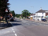
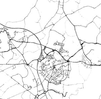
Hedge End
Encyclopedia
Hedge End is a town
and civil parish located in Hampshire
in England
. It is situated to the east of the City of Southampton
, adjoining the districts of West End
and Botley
. Hedge End lies within the Borough of Eastleigh
and is part of the Southampton Urban Area.
It is sometimes mistakenly claimed that the Rose Bowl
, home of Hampshire County Cricket Club
is part of Hedge End. The Rose Bowl is situated nearby in West End
benefitting from the road and rail links that serve the area and allowing Hedge End residents to benefit from its proximity.
 The earliest history of the area now known as Hedge End is lost in the Dark Ages. There are few records. The Belgae
tribe inhabited this area prior to the Roman conquest
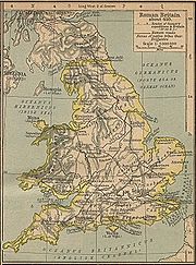
. The Roman Road
that ran from Clausentum (Southampton)
to Portus Adurni (Portchester Castle)
and Noviomagus Reginorum (Chichester)
is known to pass through the area. There is also a record that dates the crossing of the River Itchen
at Mansbridge and the crossing of the River Hamble
at Botley
to AD932. The road that linked those two river crossings would have followed the approximate route of the modern Grange Road. There is therefore evidence of travellers passing through the Hedge End area prior to the Norman Conquest. From Mansbridge, it is only 4 miles (6.4 km) to the port of Southampton
and 12 miles (19.3 km) to Winchester
. At that time, Winchester
was the capital of England
. Formerly, it was the capital of Wessex
. The route through the Hedge End area towards the town of Portchester
would therefore have been an important one. Kings of England owned land here originally known as King's Forest, now King's Copse, which was used for hunting.
Farming at the Manor of Shamblehurst is mentioned in a record dating to 1219 Although this area is within the boundary of modern Hedge End, the original Hamlet
of Hedge End first established itself on Botley Common. This land was granted to the men of Botley as common pasture in 1250. That area is towards the bottom of the hill that rises up to Netley Common and is rich with natural streams and springs. Prior to the Erection of Cottages Act 1588, an Englishman could build his house on common land
if he could raise the roof over his head and have a fire in the hearth between sunrise and sunset and claim the dwelling as his home. That procedure and the presence of a reliable water supply would have allowed a few dwellings to become established on Botley Common from 1250 onwards.
In 1267, Royal charters allowed Botley
to hold an annual fair and a weekly market. It became a market town, with people from the neighbouring Manors buying and selling goods there. The inhabitants of Botley Common would have found the proximity of that market and the mills at Botley and Bursledon to be conveniently situated.
The Manor of Shamblehurst died out in the sixteenth century. Botleigh Grange was built in the 16th century on land that was formerly part of the Manor of Shamblehurst.
The origin of the name Hedge End is not known for certain, but it was clearly in use by the beginning of the 18th century. There is an explicit reference to Hedge End in a Court Baron held at Botley Manor on 19 May 1735, concerning the tenancy of a cottage and garden at Hedge End. There is further reference to dating to 1764 concerning a £10 fine for taking in part of the common at Hedge End. Hedge End is also marked on a 1759 map of Southampton.
The Enclosure Acts ended the system of open farming on common land
. Such land was required to be fenced in and title-deeded. This allowed a number of farms to establish themselves in the Hedge End area during the late 18th and 19th centuries.
 The development of two new roads to serve the toll bridges at Northam
and Woolston brought travellers closer to Hedge End.
Northam road was opened in 1799, with a Tollgate at Hedge End. In 1839, another new road was built to provide access to the Floating Bridge
at Woolston. This new road cut through the centre of Botley Common, opening the way for further development. In modern Hedge End this is St. Johns Road.
An Enclosure Act of 1863–1865 formally divided Botley Common into plots. Some plots were used for development, 2 acres (8,093.7 m²) were for Allotments and 3 acres (12,140.6 m²) were assigned to the Lord of the Manor, William Warner
to be used for a Recreation Ground.
St. John's School was built in 1863, admitting its first 13 children on 18 January 1864. By 1885, the building had been enlarged twice. By 1888, the building was also used as a Library.
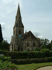
St. John's Church was consecrated on 15 July 1874. In February 1876, St. Johns, Hedge End was constituted as a separate parish for ecclesiastical purposes.
A sub-Post Office was established on 2 August 1894. Hedge End was constituted a civil Parish at its inaugural meeting on 14 December 1894. In 1895, the Parish took over responsibility for the recreation ground. The Recreation ground between St Johns Road and Bursledon road is all that remains of Botley Common.
In the late 19th Century, Hedge End, like many neighbouring villages in the area, was a strawberry growing area. Its produce was despatched to London and Scotland by train service from Botley
station.
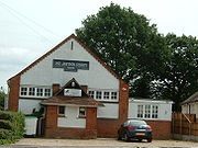
St. John's Room was built in 1907, which was the Church Hall until the Underhill Centre (Named for the Reverend Spencer Underhill, Vicar of St Johns Church 1961-1994) was opened in 2002. St. John's Room now serves as a day nursery for small children.
 To avoid the air-raids, some of Southampton's citizens rented accommodation or otherwise sought shelter in Hedge End during World War II
In 1943 and 1944, during the build up to D-Day
and the invasion of Europe, Hedge End was on the outermost edge of a huge marshalling site set up in Hampshire by the military, known as Area C Hedge End was actually part of sub-area Z within Area C with the nearest camp, camp C3, located at Netley Common. St Johns Road and Upper Northam Road are shown on a military map dated 1 May 1944 as being operational routes for the flow of military vehicles around the area. Upper Northam Road is also recorded on that map as being used as a vehicle park.
Hedge End was situated within Regulated Area (No 2)
established 31 March 1944, which placed restrictions on the movement of people in the final build-up to D-Day
.
A V-1 flying bomb
fell on HMS Cricket a military camp just outside Hedge End on 15 July 1944
enabled Hedge End to expand further in the final two decades of the 20th century, although as a Southampton suburb, rapid development had commenced in the two decades before the arrival of the motorway.
Hedge End is situated near Junctions 7 and 8 of the M27 motorway
. With good access to the new infrastructure, there was rapid expansion of the village with office parks, out-of-town superstores and new residential areas.
The most recent major development in Hedge End has been that of Grange Park, situated to the North and East of the village centre. It has continued to grow extensively for several years, and now includes an extensive public park at Dowd's Farm. In the early 1990s the village gained Hedge End railway station
, a stop on the Eastleigh-Portsmouth line. In 1992 the Parish Council renamed itself as a Town
Council.
Hedge End is twinned with Comines-Warneton
, in Belgium
. The twinning charter was signed in 1994, but very little twinning activity takes place.
On 22 May 2011 Marwell Wildlife was called in by Hampshire Constabulary
to advise how to tranquilise a white tiger
lurking in grass in the village. The tiger turned out to be a life-size cuddly toy.
 The population grew rapidly from an estimated 1,000 in the 1950s to around 17,978 in 2001.
New residential areas are still under development. The Hedge End population is predicted to reach 21,456 by 2012, with new houses to be built next to Kings Copse and Cranbourne Park.
The nearby village of Botley
was better established than Hedge End, but when the M27 was built, living close to the new motorway became more desirable. For this reason Botley
has not grown as much as Hedge End, and is projected to shrink between 2001 and 2012
. These have not been exploited, due to their proximity to the residential area. The company is still, as of February 2010, seeking ways to access the oil.
and a golf
centre. A children's paddling pool has been built on the recreation ground that was once part of Botley Common.
A community theatre/cinema (The WAVE) has been built at Wildern School with support from Eastleigh Borough
Council. A new professional theatre on the site, funded by the Borough and Town Councils, with seating up to 300 members of the local community, was completed in 2011. The Berry Theatre has gained a strong reputation in its opening months for drama, comedy, music, dance and film.
. Shamblehurst Primary School is adjacent to the Wildern site.
King Copse Primary School is also in Hedge End, located near Cranbourne Park. Kings Copse Primary School recently underwent a complete rebuild and opened in September 2008 as a state-of-the-art school. It boasts many modern facilities and provides a stunning learning environment for its pupils.
An additional primary school, Wellstead, opened at Dowd's Farm in Grange Park in April 2008, built nearly twenty years after the first primary school for the expanding Grange Park area, Berrywood.
Freegrounds (infant and junior) is the only school in Hedge End with an Ofsted
rating of 'Outstanding' in every subject.
In 2008 following a number of unsuccessful takeover attempts, presenter Mike Green bought the station which continues to broadcast its original blend of music.
Town
A town is a human settlement larger than a village but smaller than a city. The size a settlement must be in order to be called a "town" varies considerably in different parts of the world, so that, for example, many American "small towns" seem to British people to be no more than villages, while...
and civil parish located in Hampshire
Hampshire
Hampshire is a county on the southern coast of England in the United Kingdom. The county town of Hampshire is Winchester, a historic cathedral city that was once the capital of England. Hampshire is notable for housing the original birthplaces of the Royal Navy, British Army, and Royal Air Force...
in England
England
England is a country that is part of the United Kingdom. It shares land borders with Scotland to the north and Wales to the west; the Irish Sea is to the north west, the Celtic Sea to the south west, with the North Sea to the east and the English Channel to the south separating it from continental...
. It is situated to the east of the City of Southampton
Southampton
Southampton is the largest city in the county of Hampshire on the south coast of England, and is situated south-west of London and north-west of Portsmouth. Southampton is a major port and the closest city to the New Forest...
, adjoining the districts of West End
West End, Hampshire
The Parish of West End in Hampshire is situated within the borough of Eastleigh, and to the north east of the city of Southampton. As well as the village itself, the parish contains the Chartwell Green suburb of Southampton....
and Botley
Botley, Hampshire
Botley is a historic village in Hampshire, England that obtained a charter for a market from Henry III in 1267. The area has been settled since at least the 10th century....
. Hedge End lies within the Borough of Eastleigh
Eastleigh (borough)
The Borough of Eastleigh is a local government district and borough in Hampshire, England, bordering the unitary authority of Southampton, Test Valley, the City of Winchester and the borough of Fareham. Eastleigh is separated from the New Forest by Southampton Water...
and is part of the Southampton Urban Area.
It is sometimes mistakenly claimed that the Rose Bowl
Rose Bowl, Hampshire
The Rose Bowl is an English cricket ground used for county, One Day International and Test Matches. It is situated at West End, Hampshire, near Southampton, and is home to Hampshire Cricket. The design of the venue is set into an amphitheatre creating a bowl, hence the name...
, home of Hampshire County Cricket Club
Hampshire County Cricket Club
Hampshire County Cricket Club represents the historic county of Hampshire in cricket's County Championship. The club was founded in 1863 as a successor to the Hampshire county cricket teams and has played at the Antelope Ground from then until 1885, before moving to the County Ground where it...
is part of Hedge End. The Rose Bowl is situated nearby in West End
West End, Hampshire
The Parish of West End in Hampshire is situated within the borough of Eastleigh, and to the north east of the city of Southampton. As well as the village itself, the parish contains the Chartwell Green suburb of Southampton....
benefitting from the road and rail links that serve the area and allowing Hedge End residents to benefit from its proximity.
Origins
Belgae
The Belgae were a group of tribes living in northern Gaul, on the west bank of the Rhine, in the 3rd century BC, and later also in Britain, and possibly even Ireland...
tribe inhabited this area prior to the Roman conquest
Roman conquest of Britain
The Roman conquest of Britain was a gradual process, beginning effectively in AD 43 under Emperor Claudius, whose general Aulus Plautius served as first governor of Britannia. Great Britain had already frequently been the target of invasions, planned and actual, by forces of the Roman Republic and...
. The Roman Road
Roman road
The Roman roads were a vital part of the development of the Roman state, from about 500 BC through the expansion during the Roman Republic and the Roman Empire. Roman roads enabled the Romans to move armies and trade goods and to communicate. The Roman road system spanned more than 400,000 km...
that ran from Clausentum (Southampton)
Southampton
Southampton is the largest city in the county of Hampshire on the south coast of England, and is situated south-west of London and north-west of Portsmouth. Southampton is a major port and the closest city to the New Forest...
to Portus Adurni (Portchester Castle)
Portus Adurni
Portus Adurni was a Roman fortress in the Roman province of Britannia. Listed in the Notitia Dignitatum, it is generally accepted as having been located at adjoining Portchester in the English county of Hampshire and was later converted into a medieval castle known as Portchester Castle...
and Noviomagus Reginorum (Chichester)
Noviomagus Reginorum
Noviomagus Reginorum was the Roman town which is today called Chichester, situated in the modern English county of West Sussex. Alternative versions of the name include Noviomagus Regnorum, Regnentium and Regentium..-Development:...
is known to pass through the area. There is also a record that dates the crossing of the River Itchen
River Itchen, Hampshire
The River Itchen is a river in Hampshire, England. It flows from mid-Hampshire to join with Southampton Water below the Itchen Bridge in the city of Southampton. The river has a total length of , and is noted as one of England's - if not one of the World's - premier chalk streams for fly fishing,...
at Mansbridge and the crossing of the River Hamble
River Hamble
The River Hamble is a river in Hampshire, England. It rises near Bishop's Waltham and flows for some 7.5 miles through Botley, Bursledon and Swanwick before entering Southampton Water near Hamble-le-Rice and Warsash....
at Botley
Botley, Hampshire
Botley is a historic village in Hampshire, England that obtained a charter for a market from Henry III in 1267. The area has been settled since at least the 10th century....
to AD932. The road that linked those two river crossings would have followed the approximate route of the modern Grange Road. There is therefore evidence of travellers passing through the Hedge End area prior to the Norman Conquest. From Mansbridge, it is only 4 miles (6.4 km) to the port of Southampton
Southampton
Southampton is the largest city in the county of Hampshire on the south coast of England, and is situated south-west of London and north-west of Portsmouth. Southampton is a major port and the closest city to the New Forest...
and 12 miles (19.3 km) to Winchester
Winchester
Winchester is a historic cathedral city and former capital city of England. It is the county town of Hampshire, in South East England. The city lies at the heart of the wider City of Winchester, a local government district, and is located at the western end of the South Downs, along the course of...
. At that time, Winchester
Winchester
Winchester is a historic cathedral city and former capital city of England. It is the county town of Hampshire, in South East England. The city lies at the heart of the wider City of Winchester, a local government district, and is located at the western end of the South Downs, along the course of...
was the capital of England
England
England is a country that is part of the United Kingdom. It shares land borders with Scotland to the north and Wales to the west; the Irish Sea is to the north west, the Celtic Sea to the south west, with the North Sea to the east and the English Channel to the south separating it from continental...
. Formerly, it was the capital of Wessex
Wessex
The Kingdom of Wessex or Kingdom of the West Saxons was an Anglo-Saxon kingdom of the West Saxons, in South West England, from the 6th century, until the emergence of a united English state in the 10th century, under the Wessex dynasty. It was to be an earldom after Canute the Great's conquest...
. The route through the Hedge End area towards the town of Portchester
Portchester
Portchester is a locality and suburb 10km northwest of Portsmouth, England. It is part of the borough of Fareham in Hampshire. Once a small village, Portchester is now a busy part of the expanding conurbation between Portsmouth and Southampton, on the A27 main thoroughfare...
would therefore have been an important one. Kings of England owned land here originally known as King's Forest, now King's Copse, which was used for hunting.
Farming at the Manor of Shamblehurst is mentioned in a record dating to 1219 Although this area is within the boundary of modern Hedge End, the original Hamlet
Hamlet
The Tragical History of Hamlet, Prince of Denmark, or more simply Hamlet, is a tragedy by William Shakespeare, believed to have been written between 1599 and 1601...
of Hedge End first established itself on Botley Common. This land was granted to the men of Botley as common pasture in 1250. That area is towards the bottom of the hill that rises up to Netley Common and is rich with natural streams and springs. Prior to the Erection of Cottages Act 1588, an Englishman could build his house on common land
Common land
Common land is land owned collectively or by one person, but over which other people have certain traditional rights, such as to allow their livestock to graze upon it, to collect firewood, or to cut turf for fuel...
if he could raise the roof over his head and have a fire in the hearth between sunrise and sunset and claim the dwelling as his home. That procedure and the presence of a reliable water supply would have allowed a few dwellings to become established on Botley Common from 1250 onwards.
In 1267, Royal charters allowed Botley
Botley, Hampshire
Botley is a historic village in Hampshire, England that obtained a charter for a market from Henry III in 1267. The area has been settled since at least the 10th century....
to hold an annual fair and a weekly market. It became a market town, with people from the neighbouring Manors buying and selling goods there. The inhabitants of Botley Common would have found the proximity of that market and the mills at Botley and Bursledon to be conveniently situated.
The Manor of Shamblehurst died out in the sixteenth century. Botleigh Grange was built in the 16th century on land that was formerly part of the Manor of Shamblehurst.
The origin of the name Hedge End is not known for certain, but it was clearly in use by the beginning of the 18th century. There is an explicit reference to Hedge End in a Court Baron held at Botley Manor on 19 May 1735, concerning the tenancy of a cottage and garden at Hedge End. There is further reference to dating to 1764 concerning a £10 fine for taking in part of the common at Hedge End. Hedge End is also marked on a 1759 map of Southampton.
The Enclosure Acts ended the system of open farming on common land
Common land
Common land is land owned collectively or by one person, but over which other people have certain traditional rights, such as to allow their livestock to graze upon it, to collect firewood, or to cut turf for fuel...
. Such land was required to be fenced in and title-deeded. This allowed a number of farms to establish themselves in the Hedge End area during the late 18th and 19th centuries.
Growing into a village
Northam Bridge
The Northam Bridge is a road bridge across the River Itchen in Southampton, England, linking the suburbs of Northam and Bitterne Manor. The current bridge was the first major prestressed concrete road bridge to be built in the United Kingdom...
and Woolston brought travellers closer to Hedge End.
Northam road was opened in 1799, with a Tollgate at Hedge End. In 1839, another new road was built to provide access to the Floating Bridge
Woolston ferry
The Woolston Floating Bridge, was a cable ferry that crossed the River Itchen in England between Woolston and Southampton from 23 November 1836 until 11 June 1977...
at Woolston. This new road cut through the centre of Botley Common, opening the way for further development. In modern Hedge End this is St. Johns Road.
An Enclosure Act of 1863–1865 formally divided Botley Common into plots. Some plots were used for development, 2 acres (8,093.7 m²) were for Allotments and 3 acres (12,140.6 m²) were assigned to the Lord of the Manor, William Warner
William Warner
William Warner may refer to:*William Warner , English poet*William Warner , U.S. Congressman and Senator*Cheiro, aka William John Warner, , Irish astrologer and palmist...
to be used for a Recreation Ground.
St. John's School was built in 1863, admitting its first 13 children on 18 January 1864. By 1885, the building had been enlarged twice. By 1888, the building was also used as a Library.
St. John's Church was consecrated on 15 July 1874. In February 1876, St. Johns, Hedge End was constituted as a separate parish for ecclesiastical purposes.
A sub-Post Office was established on 2 August 1894. Hedge End was constituted a civil Parish at its inaugural meeting on 14 December 1894. In 1895, the Parish took over responsibility for the recreation ground. The Recreation ground between St Johns Road and Bursledon road is all that remains of Botley Common.
In the late 19th Century, Hedge End, like many neighbouring villages in the area, was a strawberry growing area. Its produce was despatched to London and Scotland by train service from Botley
Botley, Hampshire
Botley is a historic village in Hampshire, England that obtained a charter for a market from Henry III in 1267. The area has been settled since at least the 10th century....
station.
St. John's Room was built in 1907, which was the Church Hall until the Underhill Centre (Named for the Reverend Spencer Underhill, Vicar of St Johns Church 1961-1994) was opened in 2002. St. John's Room now serves as a day nursery for small children.
Wartime history
World War II
World War II, or the Second World War , was a global conflict lasting from 1939 to 1945, involving most of the world's nations—including all of the great powers—eventually forming two opposing military alliances: the Allies and the Axis...
In 1943 and 1944, during the build up to D-Day
D-Day
D-Day is a term often used in military parlance to denote the day on which a combat attack or operation is to be initiated. "D-Day" often represents a variable, designating the day upon which some significant event will occur or has occurred; see Military designation of days and hours for similar...
and the invasion of Europe, Hedge End was on the outermost edge of a huge marshalling site set up in Hampshire by the military, known as Area C Hedge End was actually part of sub-area Z within Area C with the nearest camp, camp C3, located at Netley Common. St Johns Road and Upper Northam Road are shown on a military map dated 1 May 1944 as being operational routes for the flow of military vehicles around the area. Upper Northam Road is also recorded on that map as being used as a vehicle park.
Hedge End was situated within Regulated Area (No 2)
Regulated Area (No 2)
Regulated Area was a region of England that was under government restriction during the preparations for D-Day and the Invasion of Europe during the Second World War. The order establishing Regulated Area was issued on 31 March 1944...
established 31 March 1944, which placed restrictions on the movement of people in the final build-up to D-Day
D-Day
D-Day is a term often used in military parlance to denote the day on which a combat attack or operation is to be initiated. "D-Day" often represents a variable, designating the day upon which some significant event will occur or has occurred; see Military designation of days and hours for similar...
.
A V-1 flying bomb
V-1 flying bomb
The V-1 flying bomb, also known as the Buzz Bomb or Doodlebug, was an early pulse-jet-powered predecessor of the cruise missile....
fell on HMS Cricket a military camp just outside Hedge End on 15 July 1944
Becoming a town
Development of another new road, the M27 motorwayM27 motorway
The M27 is a motorway in Hampshire, England. It is long and runs west-east from Cadnam to Portsmouth. It was opened in stages between 1975 and 1983. It is however unfinished as an extension to the east was planned...
enabled Hedge End to expand further in the final two decades of the 20th century, although as a Southampton suburb, rapid development had commenced in the two decades before the arrival of the motorway.
Hedge End is situated near Junctions 7 and 8 of the M27 motorway
M27 motorway
The M27 is a motorway in Hampshire, England. It is long and runs west-east from Cadnam to Portsmouth. It was opened in stages between 1975 and 1983. It is however unfinished as an extension to the east was planned...
. With good access to the new infrastructure, there was rapid expansion of the village with office parks, out-of-town superstores and new residential areas.
The most recent major development in Hedge End has been that of Grange Park, situated to the North and East of the village centre. It has continued to grow extensively for several years, and now includes an extensive public park at Dowd's Farm. In the early 1990s the village gained Hedge End railway station
Hedge End railway station
Hedge End railway station is situated on the northern edge of the town of Hedge End in Hampshire, England.-Services:The station is located on the Eastleigh to Fareham line, and is served by regular trains to London Waterloo and Portsmouth Harbour operated by South West Trains.The typical service...
, a stop on the Eastleigh-Portsmouth line. In 1992 the Parish Council renamed itself as a Town
Town
A town is a human settlement larger than a village but smaller than a city. The size a settlement must be in order to be called a "town" varies considerably in different parts of the world, so that, for example, many American "small towns" seem to British people to be no more than villages, while...
Council.
Hedge End is twinned with Comines-Warneton
Comines-Warneton
Comines-Warneton is a Walloon municipality located in the Belgian province of Hainaut. On January 1, 2006, Comines-Warneton had a total population of 17,562. The total area is 61.09 km² which gives a population density of 287 inhabitants per km². The name "Comines" is believed to have a...
, in Belgium
Belgium
Belgium , officially the Kingdom of Belgium, is a federal state in Western Europe. It is a founding member of the European Union and hosts the EU's headquarters, and those of several other major international organisations such as NATO.Belgium is also a member of, or affiliated to, many...
. The twinning charter was signed in 1994, but very little twinning activity takes place.
On 22 May 2011 Marwell Wildlife was called in by Hampshire Constabulary
Hampshire Constabulary
Hampshire Constabulary is the territorial police force responsible for policing Hampshire and the Isle of Wight in southern England.The force area includes the cities of Winchester, Southampton and Portsmouth...
to advise how to tranquilise a white tiger
White tiger
The white tiger is a recessive mutant of the Bengal tiger, which was reported in the wild from time to time in Assam, Bengal, Bihar and especially from the former State of Rewa.-Color comparison:...
lurking in grass in the village. The tiger turned out to be a life-size cuddly toy.
Population growth
New residential areas are still under development. The Hedge End population is predicted to reach 21,456 by 2012, with new houses to be built next to Kings Copse and Cranbourne Park.
The nearby village of Botley
Botley, Hampshire
Botley is a historic village in Hampshire, England that obtained a charter for a market from Henry III in 1267. The area has been settled since at least the 10th century....
was better established than Hedge End, but when the M27 was built, living close to the new motorway became more desirable. For this reason Botley
Botley, Hampshire
Botley is a historic village in Hampshire, England that obtained a charter for a market from Henry III in 1267. The area has been settled since at least the 10th century....
has not grown as much as Hedge End, and is projected to shrink between 2001 and 2012
Natural resources
In 2005 an oil company sought permission to search for oil reservesOil reserves
The total estimated amount of oil in an oil reservoir, including both producible and non-producible oil, is called oil in place. However, because of reservoir characteristics and limitations in petroleum extraction technologies, only a fraction of this oil can be brought to the surface, and it is...
. These have not been exploited, due to their proximity to the residential area. The company is still, as of February 2010, seeking ways to access the oil.
Community facilities
Catering for the growth in population, new community facilities have been provided, including a libraryLibrary
In a traditional sense, a library is a large collection of books, and can refer to the place in which the collection is housed. Today, the term can refer to any collection, including digital sources, resources, and services...
and a golf
Golf
Golf is a precision club and ball sport, in which competing players use many types of clubs to hit balls into a series of holes on a golf course using the fewest number of strokes....
centre. A children's paddling pool has been built on the recreation ground that was once part of Botley Common.
A community theatre/cinema (The WAVE) has been built at Wildern School with support from Eastleigh Borough
Eastleigh (borough)
The Borough of Eastleigh is a local government district and borough in Hampshire, England, bordering the unitary authority of Southampton, Test Valley, the City of Winchester and the borough of Fareham. Eastleigh is separated from the New Forest by Southampton Water...
Council. A new professional theatre on the site, funded by the Borough and Town Councils, with seating up to 300 members of the local community, was completed in 2011. The Berry Theatre has gained a strong reputation in its opening months for drama, comedy, music, dance and film.
Education
The town is served by Wildern Secondary School which currently has around 1800 pupils. The Wildern site, on Wildern Lane near the town centre, houses a high-tech media facility known as the "d.@rt Centre" (d.@rt representing Digital Art"). It also has a recently renovated sports centre which serves the local community with a large sports hall, indoor heated swimming pool, toddlers' swimming pool, gym facilities and a professional dance studio. The school also has a £250,000 Multi Use Games Area (MUGA), an all-weather surface similar to AstroturfAstroTurf
AstroTurf is a brand of artificial turf. Although the term is a registered trademark, it is sometimes used as a generic description of any kind of artificial turf. The original AstroTurf product was a short pile synthetic turf while the current products incorporate modern features such as...
. Shamblehurst Primary School is adjacent to the Wildern site.
King Copse Primary School is also in Hedge End, located near Cranbourne Park. Kings Copse Primary School recently underwent a complete rebuild and opened in September 2008 as a state-of-the-art school. It boasts many modern facilities and provides a stunning learning environment for its pupils.
An additional primary school, Wellstead, opened at Dowd's Farm in Grange Park in April 2008, built nearly twenty years after the first primary school for the expanding Grange Park area, Berrywood.
Freegrounds (infant and junior) is the only school in Hedge End with an Ofsted
Ofsted
The Office for Standards in Education, Children's Services and Skills is the non-ministerial government department of Her Majesty's Chief Inspector of Schools In England ....
rating of 'Outstanding' in every subject.
Radio station
The town has its own non-profit radio station — Skyline on 102.5FM — which exists to promote and support community organisations and events. Broadcasts reach people in Hedge End, nearby Botley, West End and beyond. Founded by David Gates, Skyline was initially funded by grants and now relies on competitively low-cost advertising from local businesses. This aims to cover the necessary running costs, i.e. radio licensing, utility bills and performing-rights fees for the music played on air. Skyline produces a wide variety of programmes — rock, country, pop, local bands, easy listening — and regularly features interviews from local community groups from the arts, environment and altruistic societies. All of the people involved in the station are unpaid volunteers. As of 10 February 2007, Skyline streams live on the internet.In 2008 following a number of unsuccessful takeover attempts, presenter Mike Green bought the station which continues to broadcast its original blend of music.