
Hebert box
Encyclopedia

Atlantic Ocean
The Atlantic Ocean is the second-largest of the world's oceanic divisions. With a total area of about , it covers approximately 20% of the Earth's surface and about 26% of its water surface area...
that are useful as predictors of hurricanes that will strike South Florida, USA
United States
The United States of America is a federal constitutional republic comprising fifty states and a federal district...
. They are named for former National Weather Service
National Weather Service
The National Weather Service , once known as the Weather Bureau, is one of the six scientific agencies that make up the National Oceanic and Atmospheric Administration of the United States government...
and National Hurricane Center
National Hurricane Center
The National Hurricane Center , located at Florida International University in Miami, Florida, is the division of the National Weather Service responsible for tracking and predicting weather systems within the tropics between the Prime Meridian and the 140th meridian west poleward to the 30th...
forecaster Paul Hebert, who observed in the late 1970s that most strong hurricanes (characterized as those with winds exceeding 110 miles per hour (49 m/s)) which had struck South Florida since 1900 had also passed through one of these two small 335-mile-by-335-mile (517-km-by-517-km) square geographic regions.
Examples include unnamed hurricanes in 1926
1926 Miami Hurricane
The 1926 Miami hurricane was a Category 4 hurricane that devastated Miami in September 1926. The storm also caused significant damage in the Florida Panhandle, the U.S. state of Alabama, and the Bahamas...
, 1928
1928 Okeechobee Hurricane
The Okeechobee hurricane, or San Felipe Segundo hurricane, was a deadly hurricane that struck the Leeward Islands, Puerto Rico, the Bahamas, and Florida in September of the 1928 Atlantic hurricane season...
, 1933, and 1935
1935 Yankee hurricane
The Yankee Hurricane of 1935 was a rare Category 1 hurricane that affected the Bahamas and South Florida in November. It remains the only tropical cyclone to affect Miami from the northeast in November. The sixth tropical cyclone and fifth hurricane of the 1935 Atlantic hurricane season, it...
, as well as the major hurricanes Donna
Hurricane Donna
Hurricane Donna in the 1960 Atlantic hurricane season was a Cape Verde-type hurricane which moved across the Leeward Islands, Puerto Rico, Hispanola, Cuba, The Bahamas, and every state on the East Coast of the United States...
and Betsy
Hurricane Betsy
Hurricane Betsy was a Category 4 hurricane of the 1965 Atlantic hurricane season which caused enormous damage in the Bahamas, Florida, and Louisiana. Betsy made its most intense landfall near the mouth of the Mississippi River, causing significant flooding of the waters of Lake Pontchartrain into...
, all of which came through an Hebert Box. Collectively these storms killed more than 2,000 people in Florida. Conversely, storms such as the major hurricanes Floyd
Hurricane Floyd
Hurricane Floyd was the sixth named storm, fourth hurricane, and third major hurricane in the 1999 Atlantic hurricane season. Floyd triggered the third largest evacuation in US history when 2.6 million coastal residents of five states were ordered from their homes as it approached...
and Gert
Hurricane Gert (1999)
Hurricane Gert was the fourth of five major hurricanes in the moderately active 1999 Atlantic hurricane season. A Cape Verde-type hurricane, Gert formed on September 11 off the coast of Africa before heading west-northwest. It reached a peak wind speed of 150 mph by September 15...
in 1999, which both were headed for Florida at one point, missed the Hebert Boxes and turned away from Florida at the last minute.
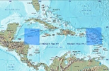
Location
The first Hebert Box is located east of Puerto RicoPuerto Rico
Puerto Rico , officially the Commonwealth of Puerto Rico , is an unincorporated territory of the United States, located in the northeastern Caribbean, east of the Dominican Republic and west of both the United States Virgin Islands and the British Virgin Islands.Puerto Rico comprises an...
over the US Virgin Islands, between 15° and 20° north latitude and 60° to 65° west longitude. This was the first area that Hebert discovered, and provides an indication for the behavior of Cape Verde
Cape Verde
The Republic of Cape Verde is an island country, spanning an archipelago of 10 islands located in the central Atlantic Ocean, 570 kilometres off the coast of Western Africa...
type storms, which form off of the western coast of Africa near the islands of the same name. This first box is useful for storms that typically form in the early part of the Atlantic hurricane season
Atlantic hurricane season
The Atlantic hurricane season is the period in a year when hurricanes usually form in the Atlantic Ocean. Tropical cyclones in the North Atlantic are called hurricanes, tropical storms, or tropical depressions. In addition, there have been several storms over the years that have not been fully...
(June through early September).
The second Hebert Box is located over the Cayman Islands
Cayman Islands
The Cayman Islands is a British Overseas Territory and overseas territory of the European Union located in the western Caribbean Sea. The territory comprises the three islands of Grand Cayman, Cayman Brac, and Little Cayman, located south of Cuba and northwest of Jamaica...
between 15° and 20° north latitude and 80° to 85° west longitude. This was the second discovered, and provides an indication for the behavior of storms that will move north to hit Florida. These are usually late-season storms that form in this region in late September and October, and this box is mostly concerned with them.
As predictors
The geography of the Hebert Boxes is the key to their use as predictors. The boxes are located such that hurricanes have plenty of space to intensify after passing through them, and the prevailing winds tend to push them towards Florida. Conversely, if they pass outside the box they are either too close to land to intensify much, or are far enough away from land that they are more subject to the influences of steering winds and other atmospheric conditions. These tend to either push the hurricane more westward across the Caribbean SeaCaribbean Sea
The Caribbean Sea is a sea of the Atlantic Ocean located in the tropics of the Western hemisphere. It is bounded by Mexico and Central America to the west and southwest, to the north by the Greater Antilles, and to the east by the Lesser Antilles....
towards the Dominican Republic
Dominican Republic
The Dominican Republic is a nation on the island of La Hispaniola, part of the Greater Antilles archipelago in the Caribbean region. The western third of the island is occupied by the nation of Haiti, making Hispaniola one of two Caribbean islands that are shared by two countries...
, Haiti
Haiti
Haiti , officially the Republic of Haiti , is a Caribbean country. It occupies the western, smaller portion of the island of Hispaniola, in the Greater Antillean archipelago, which it shares with the Dominican Republic. Ayiti was the indigenous Taíno or Amerindian name for the island...
, Cuba
Cuba
The Republic of Cuba is an island nation in the Caribbean. The nation of Cuba consists of the main island of Cuba, the Isla de la Juventud, and several archipelagos. Havana is the largest city in Cuba and the country's capital. Santiago de Cuba is the second largest city...
, or into the Gulf of Mexico
Gulf of Mexico
The Gulf of Mexico is a partially landlocked ocean basin largely surrounded by the North American continent and the island of Cuba. It is bounded on the northeast, north and northwest by the Gulf Coast of the United States, on the southwest and south by Mexico, and on the southeast by Cuba. In...
where they threaten Mexico
Mexico
The United Mexican States , commonly known as Mexico , is a federal constitutional republic in North America. It is bordered on the north by the United States; on the south and west by the Pacific Ocean; on the southeast by Guatemala, Belize, and the Caribbean Sea; and on the east by the Gulf of...
and the Gulf Coast states, or eastwards causing them to curve outwards over the Atlantic and miss landfall altogether.
While these boxes provide an indication that a hurricane may threaten South Florida, a hurricane does not have to pass through one to strike there, as were the case with the Labor Day Hurricane of 1935
Labor Day Hurricane of 1935
The 1935 Labor Day Hurricane was the strongest tropical cyclone of the 1935 Atlantic hurricane season, and one of the most intense hurricanes to make landfall in the United States in recorded history...
and Hurricane Andrew
Hurricane Andrew
Hurricane Andrew was the third Category 5 hurricane to make landfall in the United States, after the Labor Day Hurricane of 1935 and Hurricane Camille in 1969. Andrew was the first named storm and only major hurricane of the otherwise inactive 1992 Atlantic hurricane season...
, though the latter did skirt the edges of the eastern box. Additionally, a hurricane which does pass through a Hebert Box can very easily miss Florida, or indeed any landfall entirely. Hebert himself acknowledged that the boxes are not a guarantee of hurricane landfall either way, but cautions that if a hurricane passes through one, "really, really pay attention. We worry plenty in August and September when one goes through that box, and we have a certain comfort level when one misses the box."