
Harrisville, New Hampshire
Encyclopedia
Harrisville is a town
in Cheshire County
, New Hampshire
, United States
. Besides the town center, it also includes the village of Chesham
. The population of the town was 961 at the 2010 census.
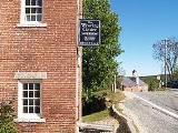
Harrisville is a unique, preserved 19th-century mill town
located in the Monadnock region
of southern New Hampshire. There are nine bodies of water in the town, many back roads and trails to explore, and two original train depots at Harrisville and Chesham.
and gristmill
was built here in 1774. Harrisville township was formed in 1870 from lands ceded by Marlborough
, Dublin
, Hancock
, Nelson
, and Roxbury
. The Manchester & Keene Railroad opened in 1878, helping it prosper as a textile
mill town. It was named for Milan Harris, whose stone and brick Cheshire Mills operated until 1970, but look virtually unchanged since the mid-19th century.
Today, the Cheshire Mills are protected as part of the Harrisville Historic District, a National Historic Landmark
which includes the center of town. With its red brick buildings and mills reflected in Harrisville Pond
and canal, the village is frequently photographed as an iconic example of picturesque old New England
. The Harrisville Rural District
includes the southern part of the town near the Dublin border.
, the town has a total area of 20.2 square miles (52.3 km²), of which 18.6 square miles (48.2 km²) is land and 1.6 square miles (4.1 km²) is water, comprising 7.80% of the town. The highest point in Harrisville is the summit of Cobb Hill, at 1909 feet (581.9 m) above sea level
. Roughly the western half of Harrisville, drained by Minnewawa Brook, lies within the Ashuelot River
watershed
, part of the Connecticut River
basin, while the eastern half, drained by Nubanusit Brook
, is in the Merrimack River
watershed. Significant lakes include Silver Lake
, Seaver Reservoir, and Chesham Pond on the western side, and Harrisville Pond
and Skatutakee Lake
draining to the east.
The Community Church is a member of the United Church of Christ
(UCC) and the American Baptist Association
, and it retains a united congregation using both buildings. There is also a Roman Catholic Church in Harrisville.
of 2000, there were 1,075 people, 449 households, and 306 families residing in the town. The population density
was 57.4 people per square mile (22.1/km²). There were 698 housing units at an average density of 37.2 per square mile (14.4/km²). The racial makeup of the town was 97.77% White, 0.09% African American, 0.56% Native American, 0.28% Asian, and 1.30% from two or more races. Hispanic or Latino of any race were 0.56% of the population.
There were 449 households out of which 31.2% had children under the age of 18 living with them, 55.2% were married couples
living together, 8.9% had a female householder with no husband present, and 31.8% were non-families. 26.5% of all households were made up of individuals and 7.8% had someone living alone who was 65 years of age or older. The average household size was 2.39 and the average family size was 2.87.
In the town the population was spread out with 24.8% under the age of 18, 4.6% from 18 to 24, 25.7% from 25 to 44, 30.0% from 45 to 64, and 15.0% who were 65 years of age or older. The median age was 43 years. For every 100 females there were 92.3 males. For every 100 females age 18 and over, there were 87.0 males.
The median income for a household in the town was $48,625, and the median income for a family was $55,083. Males had a median income of $34,625 versus $27,171 for females. The per capita income
for the town was $25,397. About 4.3% of families and 5.7% of the population were below the poverty line, including 8.0% of those under age 18 and 3.8% of those age 65 or over.
New England town
The New England town is the basic unit of local government in each of the six New England states. Without a direct counterpart in most other U.S. states, New England towns are conceptually similar to civil townships in other states, but are incorporated, possessing powers like cities in other...
in Cheshire County
Cheshire County, New Hampshire
-Demographics:As of the census of 2000, there were 73,825 people, 28,299 households, and 18,790 families residing in the county. The population density was 104 people per square mile . There were 31,876 housing units at an average density of 45 per square mile...
, New Hampshire
New Hampshire
New Hampshire is a state in the New England region of the northeastern United States of America. The state was named after the southern English county of Hampshire. It is bordered by Massachusetts to the south, Vermont to the west, Maine and the Atlantic Ocean to the east, and the Canadian...
, United States
United States
The United States of America is a federal constitutional republic comprising fifty states and a federal district...
. Besides the town center, it also includes the village of Chesham
Chesham, New Hampshire
Chesham is a village within the town of Harrisville in Cheshire County, New Hampshire, United States. The village is listed on the National Register of Historic Places.Chesham has an elementary school called Wells Memorial School...
. The population of the town was 961 at the 2010 census.
Harrisville is a unique, preserved 19th-century mill town
Mill town
A mill town, also known as factory town or mill village, is typically a settlement that developed around one or more mills or factories .- United Kingdom:...
located in the Monadnock region
Monadnock Region
The Monadnock Region is a tourism region in southwestern New Hampshire. It is named after Mount Monadnock, the major geographic landmark in the region. The Monadnock Region is composed of all of Cheshire County and western Hillsborough County. The largest city in the region is Keene...
of southern New Hampshire. There are nine bodies of water in the town, many back roads and trails to explore, and two original train depots at Harrisville and Chesham.
History
First known as Twitchell's Mills, a combination sawmillSawmill
A sawmill is a facility where logs are cut into boards.-Sawmill process:A sawmill's basic operation is much like those of hundreds of years ago; a log enters on one end and dimensional lumber exits on the other end....
and gristmill
Gristmill
The terms gristmill or grist mill can refer either to a building in which grain is ground into flour, or to the grinding mechanism itself.- Early history :...
was built here in 1774. Harrisville township was formed in 1870 from lands ceded by Marlborough
Marlborough, New Hampshire
Marlborough is a town in Cheshire County, New Hampshire, United States. The population was 2,063 at the 2010 census. The town is home to the Kensan-Devan Wildlife Sanctuary at Meetinghouse Pond....
, Dublin
Dublin, New Hampshire
Dublin is a town in Cheshire County, New Hampshire, United States. The population was 1,597 at the 2010 census. It is home to both the Dublin School and Yankee Magazine.-History:...
, Hancock
Hancock, New Hampshire
Hancock is a town in Hillsborough County, New Hampshire, United States. The population was 1,654 at the 2010 census. Hancock is home to the Welch Family Farm Forest....
, Nelson
Nelson, New Hampshire
Nelson is a town in Cheshire County, New Hampshire, United States. The population was 729 at the 2010 census. Nelson includes the village of Munsonville.-History:...
, and Roxbury
Roxbury, New Hampshire
Roxbury is a town in Cheshire County, New Hampshire, United States. The population was 229 at the 2010 census.- History :The smallest town in Cheshire County, Roxbury was incorporated in 1812 from portions of Nelson, Marlborough, and Keene...
. The Manchester & Keene Railroad opened in 1878, helping it prosper as a textile
Textile
A textile or cloth is a flexible woven material consisting of a network of natural or artificial fibres often referred to as thread or yarn. Yarn is produced by spinning raw fibres of wool, flax, cotton, or other material to produce long strands...
mill town. It was named for Milan Harris, whose stone and brick Cheshire Mills operated until 1970, but look virtually unchanged since the mid-19th century.
Today, the Cheshire Mills are protected as part of the Harrisville Historic District, a National Historic Landmark
National Historic Landmark
A National Historic Landmark is a building, site, structure, object, or district, that is officially recognized by the United States government for its historical significance...
which includes the center of town. With its red brick buildings and mills reflected in Harrisville Pond
Harrisville Pond
Harrisville Pond is a water body located in Cheshire County in southwestern New Hampshire, in the town of Harrisville. It is one of many lakes and ponds along Nubanusit Brook. Water from Nubanusit Lake flows via the Great Meadows into the pond on the north side and out of the pond at two dams on...
and canal, the village is frequently photographed as an iconic example of picturesque old New England
New England
New England is a region in the northeastern corner of the United States consisting of the six states of Maine, New Hampshire, Vermont, Massachusetts, Rhode Island, and Connecticut...
. The Harrisville Rural District
Harrisville Rural District
Harrisville Rural District was listed on the National Register of Historic Places in 1987. According to the boundary description given, it is located in a rural area to the south of the Harrisville Historic District, near the town boundary of Dublin, New Hampshire....
includes the southern part of the town near the Dublin border.
Geography
According to the United States Census BureauUnited States Census Bureau
The United States Census Bureau is the government agency that is responsible for the United States Census. It also gathers other national demographic and economic data...
, the town has a total area of 20.2 square miles (52.3 km²), of which 18.6 square miles (48.2 km²) is land and 1.6 square miles (4.1 km²) is water, comprising 7.80% of the town. The highest point in Harrisville is the summit of Cobb Hill, at 1909 feet (581.9 m) above sea level
Sea level
Mean sea level is a measure of the average height of the ocean's surface ; used as a standard in reckoning land elevation...
. Roughly the western half of Harrisville, drained by Minnewawa Brook, lies within the Ashuelot River
Ashuelot River
The Ashuelot River is a tributary of the Connecticut River, approximately long, in southwestern New Hampshire in the United States. It drains a mountainous area of , including much of the area known as the Monadnock Region...
watershed
Drainage basin
A drainage basin is an extent or an area of land where surface water from rain and melting snow or ice converges to a single point, usually the exit of the basin, where the waters join another waterbody, such as a river, lake, reservoir, estuary, wetland, sea, or ocean...
, part of the Connecticut River
Connecticut River
The Connecticut River is the largest and longest river in New England, and also an American Heritage River. It flows roughly south, starting from the Fourth Connecticut Lake in New Hampshire. After flowing through the remaining Connecticut Lakes and Lake Francis, it defines the border between the...
basin, while the eastern half, drained by Nubanusit Brook
Nubanusit Brook
Nubanusit Brook is a stream located in southern New Hampshire in the United States. It is a tributary of the Contoocook River, part of the Merrimack River watershed.Nubanusit Brook begins at the outlet of Nubanusit Lake in Nelson, New Hampshire...
, is in the Merrimack River
Merrimack River
The Merrimack River is a river in the northeastern United States. It rises at the confluence of the Pemigewasset and Winnipesaukee rivers in Franklin, New Hampshire, flows southward into Massachusetts, and then flows northeast until it empties into the Atlantic Ocean at Newburyport...
watershed. Significant lakes include Silver Lake
Silver Lake (Harrisville, New Hampshire)
Silver Lake is a water body located in Cheshire County in southwestern New Hampshire, in the towns of Harrisville and Nelson. Water from Silver Lake flows via Minnewawa Brook and The Branch to the Ashuelot River, a tributary of the Connecticut River....
, Seaver Reservoir, and Chesham Pond on the western side, and Harrisville Pond
Harrisville Pond
Harrisville Pond is a water body located in Cheshire County in southwestern New Hampshire, in the town of Harrisville. It is one of many lakes and ponds along Nubanusit Brook. Water from Nubanusit Lake flows via the Great Meadows into the pond on the north side and out of the pond at two dams on...
and Skatutakee Lake
Skatutakee Lake
Skatutakee Lake is a water body located in Cheshire County in southwestern New Hampshire, in the town of Harrisville. Water from Skatutakee Lake flows via Nubanusit Brook to the Contoocook River in Peterborough, New Hampshire and ultimately to the Merrimack River....
draining to the east.
Churches
The Community Church of Harrisville and Chesham was formed from Chesham Baptist Church and Harrisville Congregational Church. Chesham Baptist Church dates back to 1785. The church building was originally built in 1797, re-modeled in 1830, and again re-modeled in 1844. The Evangelical Congregational church of Harrisville dates back to 1840, and the church building was erected in 1840-43.The Community Church is a member of the United Church of Christ
United Church of Christ
The United Church of Christ is a mainline Protestant Christian denomination primarily in the Reformed tradition but also historically influenced by Lutheranism. The Evangelical and Reformed Church and the Congregational Christian Churches united in 1957 to form the UCC...
(UCC) and the American Baptist Association
American Baptist Association
The American Baptist Association , formed in 1924, is an association of nearly 2,000 theologically conservative churches that are Landmark Baptist in their missions and teachings...
, and it retains a united congregation using both buildings. There is also a Roman Catholic Church in Harrisville.
Demographics
As of the censusCensus
A census is the procedure of systematically acquiring and recording information about the members of a given population. It is a regularly occurring and official count of a particular population. The term is used mostly in connection with national population and housing censuses; other common...
of 2000, there were 1,075 people, 449 households, and 306 families residing in the town. The population density
Population density
Population density is a measurement of population per unit area or unit volume. It is frequently applied to living organisms, and particularly to humans...
was 57.4 people per square mile (22.1/km²). There were 698 housing units at an average density of 37.2 per square mile (14.4/km²). The racial makeup of the town was 97.77% White, 0.09% African American, 0.56% Native American, 0.28% Asian, and 1.30% from two or more races. Hispanic or Latino of any race were 0.56% of the population.
There were 449 households out of which 31.2% had children under the age of 18 living with them, 55.2% were married couples
Marriage
Marriage is a social union or legal contract between people that creates kinship. It is an institution in which interpersonal relationships, usually intimate and sexual, are acknowledged in a variety of ways, depending on the culture or subculture in which it is found...
living together, 8.9% had a female householder with no husband present, and 31.8% were non-families. 26.5% of all households were made up of individuals and 7.8% had someone living alone who was 65 years of age or older. The average household size was 2.39 and the average family size was 2.87.
In the town the population was spread out with 24.8% under the age of 18, 4.6% from 18 to 24, 25.7% from 25 to 44, 30.0% from 45 to 64, and 15.0% who were 65 years of age or older. The median age was 43 years. For every 100 females there were 92.3 males. For every 100 females age 18 and over, there were 87.0 males.
The median income for a household in the town was $48,625, and the median income for a family was $55,083. Males had a median income of $34,625 versus $27,171 for females. The per capita income
Per capita income
Per capita income or income per person is a measure of mean income within an economic aggregate, such as a country or city. It is calculated by taking a measure of all sources of income in the aggregate and dividing it by the total population...
for the town was $25,397. About 4.3% of families and 5.7% of the population were below the poverty line, including 8.0% of those under age 18 and 3.8% of those age 65 or over.