

Green Sands Beach
Encyclopedia

Ka Lae
Ka Lae , also known as South Point, is the southernmost point of the Big Island of Hawaii and of the 50 United States. The Ka Lae area is registered as a National Historic Landmark District under the name South Point Complex...
, in the Kaū district
Kau, Hawaii
thumb|right|300px|The districts of the [[Hawaii |Big Island]]. From Northernmost, clockwise; [[Kohala, Hawaii|Kohala]], [[Hamakua]], [[Hilo, Hawaii|Hilo]], [[Puna, Hawaii|Puna]], Kau , [[Kona District, Hawaii|Kona]]...
of the island of Hawaii
Hawaii (island)
The Island of Hawaii, also called the Big Island or Hawaii Island , is a volcanic island in the North Pacific Ocean...
. One of only two green sand beaches in the United States, the other being in Guam
Guam
Guam is an organized, unincorporated territory of the United States located in the western Pacific Ocean. It is one of five U.S. territories with an established civilian government. Guam is listed as one of 16 Non-Self-Governing Territories by the Special Committee on Decolonization of the United...
, the beach gets distinctive coloring from olivine
Olivine
The mineral olivine is a magnesium iron silicate with the formula 2SiO4. It is a common mineral in the Earth's subsurface but weathers quickly on the surface....
crystals found in the enclosing cinder cone
Cinder cone
According to the , Cinder Cone is the proper name of 1 cinder cone in Canada and 7 cinder cones in the United States:In Canada: Cinder Cone In the United States:...
.
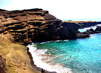
Characteristics
Bay
A bay is an area of water mostly surrounded by land. Bays generally have calmer waters than the surrounding sea, due to the surrounding land blocking some waves and often reducing winds. Bays also exist as an inlet in a lake or pond. A large bay may be called a gulf, a sea, a sound, or a bight...
half circled by Puu Mahana, a cinder cone
Cinder cone
According to the , Cinder Cone is the proper name of 1 cinder cone in Canada and 7 cinder cones in the United States:In Canada: Cinder Cone In the United States:...
formed over 49,000 years ago and associated with the southwest rift of Mauna Loa
Mauna Loa
Mauna Loa is one of five volcanoes that form the Island of Hawaii in the U.S. state of Hawaii in the Pacific Ocean, and the largest on Earth in terms of volume and area covered. It is an active shield volcano, with a volume estimated at approximately , although its peak is about lower than that...
. Since its last eruption, the cinder cone has partially collapsed and been partially eroded by the ocean. The beach is sometimes named after the cinder cone, and sometimes after the area of land called Papakōlea, which comes from papa kōlea, which means plover
Plover
Plovers are a widely distributed group of wading birds belonging to the subfamily Charadriinae. There are about 40 species in the subfamily, most of them called "plover" or "dotterel". The closely related lapwing subfamily, Vanellinae, comprises another 20-odd species.Plovers are found throughout...
flats in the Hawaiian language
Hawaiian language
The Hawaiian language is a Polynesian language that takes its name from Hawaii, the largest island in the tropical North Pacific archipelago where it developed. Hawaiian, along with English, is an official language of the state of Hawaii...
. Papakōlea is the area near the crater where the Pacific Golden Plover
Pacific Golden Plover
The Pacific Golden Plover is a medium-sized plover.The 23–26 cm long breeding adult is spotted gold and black on the crown, back and wings. Its face and neck are black with a white border and it has a black breast and a dark rump. The legs are black...
(Pluvialis fulva) are sometimes seen in winter.
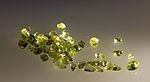
The cinder cone is rich in olivine
Olivine
The mineral olivine is a magnesium iron silicate with the formula 2SiO4. It is a common mineral in the Earth's subsurface but weathers quickly on the surface....
, a silicate
Silicate
A silicate is a compound containing a silicon bearing anion. The great majority of silicates are oxides, but hexafluorosilicate and other anions are also included. This article focuses mainly on the Si-O anions. Silicates comprise the majority of the earth's crust, as well as the other...
mineral containing iron
Iron
Iron is a chemical element with the symbol Fe and atomic number 26. It is a metal in the first transition series. It is the most common element forming the planet Earth as a whole, forming much of Earth's outer and inner core. It is the fourth most common element in the Earth's crust...
and magnesium
Magnesium
Magnesium is a chemical element with the symbol Mg, atomic number 12, and common oxidation number +2. It is an alkaline earth metal and the eighth most abundant element in the Earth's crust and ninth in the known universe as a whole...
, also known as peridot
Peridot
-Chemistry:The chemical composition of peridot is 2SiO4, with Mg in greater quantities than Fe.-Etymology:The origin of the name "peridot" is uncertain...
when of gem quality. Olivine is a common mineral component of Hawaiian lava
Lava
Lava refers both to molten rock expelled by a volcano during an eruption and the resulting rock after solidification and cooling. This molten rock is formed in the interior of some planets, including Earth, and some of their satellites. When first erupted from a volcanic vent, lava is a liquid at...
s and one of the first crystals to form as magma
Magma
Magma is a mixture of molten rock, volatiles and solids that is found beneath the surface of the Earth, and is expected to exist on other terrestrial planets. Besides molten rock, magma may also contain suspended crystals and dissolved gas and sometimes also gas bubbles. Magma often collects in...
cools. Olivine is locally known as "Hawaiian Diamond" and is notably found in Oahu's
Oahu
Oahu or Oahu , known as "The Gathering Place", is the third largest of the Hawaiian Islands and most populous of the islands in the U.S. state of Hawaii. The state capital Honolulu is located on the southeast coast...
famous Diamond Head
Diamond Head, Hawaii
Diamond Head is the name of a volcanic tuff cone on the Hawaiian island of Oahu and known to Hawaiians as Lēahi, most likely from lae 'browridge, promontory' plus ahi 'tuna' because the shape of the ridgeline resembles the shape of a tuna's dorsal fin...
landmark. The source of the green coloration of the beach sands is due to the olivine crystals which are winnowed from the eroding headland by the action of the sea. Olivine, being denser and tougher than the ash fragments, glass and black pyroxene
Pyroxene
The pyroxenes are a group of important rock-forming inosilicate minerals found in many igneous and metamorphic rocks. They share a common structure consisting of single chains of silica tetrahedra and they crystallize in the monoclinic and orthorhombic systems...
of the rest of the rocks and lava flows, tends to accumulate on the beach whereas the usual volcanic sand
Black sand
Black sand is sand that is black in color. One type of black sand is a heavy, glossy, partly magnetic mixture of usually fine sands, found as part of a placer deposit. Another type of black sand, found on beaches near a volcano, consists of tiny fragments of lava.While some beaches are...
is swept out to sea. Although these crystals are eventually washed away as well, the constant erosion of the cinder cone ensures a steady supply of sand for the foreseeable future—eventually, however, the supply will run out and the beach will look like any other.
The formation of the cinder cone is currently a point of contention, with some arguing that lava flowing into the sea was suddenly cooled, forming an edifice on the coastline (a littoral cone
Cinder cone
According to the , Cinder Cone is the proper name of 1 cinder cone in Canada and 7 cinder cones in the United States:In Canada: Cinder Cone In the United States:...
) and others noting that the cone was most likely too far away from the ocean at the time of formation to make such an event possible. Regardless of how it was formed according to the United States Geological Survey
United States Geological Survey
The United States Geological Survey is a scientific agency of the United States government. The scientists of the USGS study the landscape of the United States, its natural resources, and the natural hazards that threaten it. The organization has four major science disciplines, concerning biology,...
, the last lava flow in the area ended over 10,000 years ago, making the area one of the more stable features in the geologically turbulent Kaū region. As such, the geologic history of the site can be seen in the rock surrounding the beach and bay, which are not subject to erosion and thus display geologic layers formed by previous eruptions, lava flows, and other volcanic events. In addition, the current patterns of erosion can be seen first-hand, as only the portions at the bottom of the cinder cone collapse have been subject to the waves and turned into green sand; the remaining portions appear gray.
Green sand in space
Gemini Observatory
The Gemini Observatory is an astronomical observatory consisting of two telescopes at sites in Hawai‘i and Chile. Together, the twin Gemini telescopes provide almost complete coverage of both the northern and southern skies...
observed the collision of Deep Impact with the comet
Comet
A comet is an icy small Solar System body that, when close enough to the Sun, displays a visible coma and sometimes also a tail. These phenomena are both due to the effects of solar radiation and the solar wind upon the nucleus of the comet...
9P/Tempel
9P/Tempel
Tempel 1 , is a periodic comet discovered by Wilhelm Tempel in 1867. It currently completes an orbit of the Sun every 5.5 years. Tempel 1 was the target of the Deep Impact space mission, which photographed a deliberate high-speed impact upon the comet in 2005...
. By examining the aftermath of the collision in infrared, scientists were able to confirm that a portion of the material ejected was olivine crystals similar in shape and structure to the sand found at Papakolea Beach, albeit smaller. Although the comet Hale-Bopp routinely sheds green crystals from its surface, this was the first time that green sand was confirmed to exist within a comet already "cooked" by the sun.
Access
The beach is located at coordinates 18.936379°N 155.646315°W, about 3 miles (4.8 km) east of Ka LaeKa Lae
Ka Lae , also known as South Point, is the southernmost point of the Big Island of Hawaii and of the 50 United States. The Ka Lae area is registered as a National Historic Landmark District under the name South Point Complex...
(known as South Point) on the island of Hawaii
Hawaii (island)
The Island of Hawaii, also called the Big Island or Hawaii Island , is a volcanic island in the North Pacific Ocean...
.
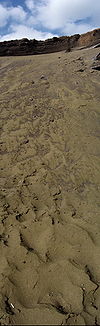
It is surrounded by pasture
Pasture
Pasture is land used for grazing. Pasture lands in the narrow sense are enclosed tracts of farmland, grazed by domesticated livestock, such as horses, cattle, sheep or swine. The vegetation of tended pasture, forage, consists mainly of grasses, with an interspersion of legumes and other forbs...
lands and is only accessible on foot or by using a vehicle equipped with four-wheel drive. To actually reach the beach, an additional climb down the cinder cone is required.