

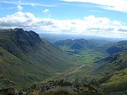
Great Langdale
Encyclopedia
Valley
In geology, a valley or dale is a depression with predominant extent in one direction. A very deep river valley may be called a canyon or gorge.The terms U-shaped and V-shaped are descriptive terms of geography to characterize the form of valleys...
in the Lake District National Park
Lake District National Park
The Lake District National Park is located in the north-west of England and is the largest of the English National Parks and the second largest in the United Kingdom. It is in the central and most-visited part of the Lake District....
in the county of Cumbria
Cumbria
Cumbria , is a non-metropolitan county in North West England. The county and Cumbria County Council, its local authority, came into existence in 1974 after the passage of the Local Government Act 1972. Cumbria's largest settlement and county town is Carlisle. It consists of six districts, and in...
, in the northwest of England
England
England is a country that is part of the United Kingdom. It shares land borders with Scotland to the north and Wales to the west; the Irish Sea is to the north west, the Celtic Sea to the south west, with the North Sea to the east and the English Channel to the south separating it from continental...
. It is often simply referred to as Langdale, the epithet Great distinguishing it from the neighbouring valley of Little Langdale
Little Langdale
Little Langdale is a valley in the Lake District, England containing Little Langdale Tarn and a hamlet also called Little Langdale. A second tarn, Blea Tarn, is in a hanging valley between Little Langdale and the larger Great Langdale to the north...
.
Langdale is a popular location for hikers
Hiking
Hiking is an outdoor activity which consists of walking in natural environments, often in mountainous or other scenic terrain. People often hike on hiking trails. It is such a popular activity that there are numerous hiking organizations worldwide. The health benefits of different types of hiking...
, climbers, fell-runners and other outdoor enthusiasts, who are attracted by the many fells ringing the head of the valley. One of the best known features of Great Langdale are the Langdale Pikes, a group of peaks on the northern side of the dale. England's highest mountain, Scafell Pike
Scafell Pike
Scafell Pike is the highest mountain in England at . It is located in Lake District National Park sometimes confused with the neighbouring Sca Fell, to which it is connected by the col of Mickledore...
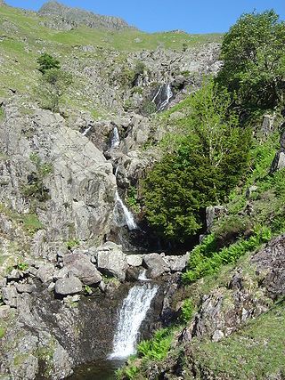
, can be climbed by a route from Langdale. Langdale has spectacular views of, in particular, Dungeon Ghyll Force waterfall
Waterfall
A waterfall is a place where flowing water rapidly drops in elevation as it flows over a steep region or a cliff.-Formation:Waterfalls are commonly formed when a river is young. At these times the channel is often narrow and deep. When the river courses over resistant bedrock, erosion happens...
, Harrison Stickle
Harrison Stickle
Harrison Stickle is a fell in the central part of the English Lake District, situated above Great Langdale. The fell is one of the three fells which make up the picturesque Langdale Pikes, the others being Pike of Stickle and Loft Crag. Together they make up one of the most picturesque, and...
and the Pike of Stickle
Pike of Stickle
Pike of Stickle, also known as Pike O’ Stickle, is a fell in the English Lake District. It reaches a height of 709 metres and is situated in the central part of the national park in the valley of Great Langdale...
.
Langdale was an important site during the Neolithic
Neolithic
The Neolithic Age, Era, or Period, or New Stone Age, was a period in the development of human technology, beginning about 9500 BC in some parts of the Middle East, and later in other parts of the world. It is traditionally considered as the last part of the Stone Age...
period for producing stone axes
Langdale axe industry
The Langdale axe industry is the name given by archaeologists to the centre of a specialised stone tool manufacturing at Great Langdale in England's Lake District during the Neolithic period .The area has outcrops of fine-grained greenstone suitable for making polished axes which have been...
, and was also one of the centres of the Lakeland slate industry.
History
Langdale is known to archaeologists as the source of a particular type of NeolithicNeolithic
The Neolithic Age, Era, or Period, or New Stone Age, was a period in the development of human technology, beginning about 9500 BC in some parts of the Middle East, and later in other parts of the world. It is traditionally considered as the last part of the Stone Age...
polished stone axe
Axe
The axe, or ax, is an implement that has been used for millennia to shape, split and cut wood; to harvest timber; as a weapon; and as a ceremonial or heraldic symbol...
head, created on the slopes of the Pike of Stickle and traded all over prehistoric Great Britain
Great Britain
Great Britain or Britain is an island situated to the northwest of Continental Europe. It is the ninth largest island in the world, and the largest European island, as well as the largest of the British Isles...
and Europe
Europe
Europe is, by convention, one of the world's seven continents. Comprising the westernmost peninsula of Eurasia, Europe is generally 'divided' from Asia to its east by the watershed divides of the Ural and Caucasus Mountains, the Ural River, the Caspian and Black Seas, and the waterways connecting...
. It also supplied stone for some Bronze Age
Bronze Age
The Bronze Age is a period characterized by the use of copper and its alloy bronze as the chief hard materials in the manufacture of some implements and weapons. Chronologically, it stands between the Stone Age and Iron Age...
items, such as stone wrist-guards. Neolithic cup and ring marks are found on the Langdale Boulders at Copt Howe.
Geography
The mouth of the valley is located at Skelwith Bridge, which lies about two miles west of the town of AmblesideAmbleside
Ambleside is a town in Cumbria, in North West England.Historically within the county of Westmorland, it is situated at the head of Windermere, England's largest lake...
. The Langdale valley contains two villages, Chapel Stile and Elterwater
Elterwater
Elter Water is a small lake that lies half a mile south-east of the village of Elterwater. Both are situated in the valley of Great Langdale in the English Lake District...
, and a hamlet
Hamlet
The Tragical History of Hamlet, Prince of Denmark, or more simply Hamlet, is a tragedy by William Shakespeare, believed to have been written between 1599 and 1601...
at High Close. It is a U-shaped valley
U-shaped valley
A U-shaped valley also known as a glacial trough is one formed by the process of glaciation. It has a characteristic U-shape, with steep, straight sides, and a flat bottom. Glaciated valleys are formed when a glacier travels across and down a slope, carving the valley by the action of scouring...
formed by glacier
Glacier
A glacier is a large persistent body of ice that forms where the accumulation of snow exceeds its ablation over many years, often centuries. At least 0.1 km² in area and 50 m thick, but often much larger, a glacier slowly deforms and flows due to stresses induced by its weight...
s, while Little Langdale is a hanging valley.
Slate industry
Langdale and Elterwater were centres of the Lakeland slate industry. Two slate workings, Elterwater Quarry and Spout Cragg Quarry, have been more or less continually working using modern methods. Elterwater is the larger of the two, and like Spout Cragg, is operated by the Burlington Stone company. There are various other local quarries now fallen into disuse, such as Lingmoor, Banks, Thrang Crag and Colt Howe.Langdale is also the name of a valley in the Howgill Fells
Howgill Fells
The Howgill Fells are hills in Northern England between the Lake District and the Yorkshire Dales, lying roughly in between the vertices of a triangle made by the towns of Sedbergh, Kirkby Stephen and Tebay....
, elsewhere in Cumbria
Cumbria
Cumbria , is a non-metropolitan county in North West England. The county and Cumbria County Council, its local authority, came into existence in 1974 after the passage of the Local Government Act 1972. Cumbria's largest settlement and county town is Carlisle. It consists of six districts, and in...
.
Axe industry
Langdale had a productive stone axe industry during the NeolithicNeolithic
The Neolithic Age, Era, or Period, or New Stone Age, was a period in the development of human technology, beginning about 9500 BC in some parts of the Middle East, and later in other parts of the world. It is traditionally considered as the last part of the Stone Age...
period. The area has outcrops of fine-grained greenstone
Greenstone (archaeology)
Greenstone is a common generic term for valuable, green-hued minerals and metamorphosed igneous rocks and stones, that were used in the fashioning of hardstone carvings such as jewelry, statuettes, ritual tools, and various other artefacts in early cultures...
suitable for making polished axes which have been found distributed across the British Isles
British Isles
The British Isles are a group of islands off the northwest coast of continental Europe that include the islands of Great Britain and Ireland and over six thousand smaller isles. There are two sovereign states located on the islands: the United Kingdom of Great Britain and Northern Ireland and...
. The rock is an epidotised
Epidote
Epidote is a calcium aluminium iron sorosilicate mineral, Ca2Al2O, crystallizing in the monoclinic system. Well-developed crystals are of frequent occurrence: they are commonly prismatic in habit, the direction of elongation being perpendicular to the single plane of symmetry. The faces are often...
greenstone quarried or perhaps just collected from the scree slopes in the Langdale Valley on Harrison Stickle
Harrison Stickle
Harrison Stickle is a fell in the central part of the English Lake District, situated above Great Langdale. The fell is one of the three fells which make up the picturesque Langdale Pikes, the others being Pike of Stickle and Loft Crag. Together they make up one of the most picturesque, and...
and Pike of Stickle
Pike of Stickle
Pike of Stickle, also known as Pike O’ Stickle, is a fell in the English Lake District. It reaches a height of 709 metres and is situated in the central part of the national park in the valley of Great Langdale...
.
The Langdale Pikes
One of the best known features of Great Langdale are the Langdale Pikes, a group of peaks on the northern side of the dale. From below, they appear as a sharp rocky ridge, though they are only precipitous on their southern side; to the north, the land sweeps gently to High Raise, the parent peak of the range. The Pikes themselves include (from west to east) Pike of Stickle, Loft Crag, Harrison Stickle and Pavey Ark.Pike of Stickle
Pike of Stickle, also known as Pike O’ Stickle, reaches a height of 709 metres (2,326 feet). The rearward slopes show evidence of the Pavey Ark Member, pebbly sandstoneSandstone
Sandstone is a sedimentary rock composed mainly of sand-sized minerals or rock grains.Most sandstone is composed of quartz and/or feldspar because these are the most common minerals in the Earth's crust. Like sand, sandstone may be any colour, but the most common colours are tan, brown, yellow,...
and breccia
Breccia
Breccia is a rock composed of broken fragments of minerals or rock cemented together by a fine-grained matrix, that can be either similar to or different from the composition of the fragments....
. The Langdale face displays several strata, from the top The Lingmell Formation, Crinkle Member and Bad Step Tuff. These are composed, respectively, of tuff
Tuff
Tuff is a type of rock consisting of consolidated volcanic ash ejected from vents during a volcanic eruption. Tuff is sometimes called tufa, particularly when used as construction material, although tufa also refers to a quite different rock. Rock that contains greater than 50% tuff is considered...
, lapilli
Lapilli
Lapilli is a size classification term for tephra, which is material that falls out of the air during a volcanic eruption or during some meteorite impacts. Lapilli means "little stones" in Latin. They are in some senses similar to ooids or pisoids in calcareous sediments.By definition lapilli range...
-tuff and breccia; rhyolitic tuff and breccia; and rhyolitic lava
Lava
Lava refers both to molten rock expelled by a volcano during an eruption and the resulting rock after solidification and cooling. This molten rock is formed in the interior of some planets, including Earth, and some of their satellites. When first erupted from a volcanic vent, lava is a liquid at...
-like tuff.
Despite the peaked profile the summit is wide enough for a sizeable cairn
Cairn
Cairn is a term used mainly in the English-speaking world for a man-made pile of stones. It comes from the or . Cairns are found all over the world in uplands, on moorland, on mountaintops, near waterways and on sea cliffs, and also in barren desert and tundra areas...
surrounded by a small level area. Loft Crag and Gimmer Crag steal the attention in the foreground while Bowfell
Bowfell
Bowfell is a pyramid-shaped mountain lying at the heart of the English Lake District, in the Southern Fells area. It is the sixth highest mountain in the lakes and one of the most popular of the Lake District fells...
impresses across Langdale. A wide swathe of the Southern Fells
Southern Fells
Image:Annotated Scafell range.jpg|thumb|300px|The Scafellsrect 23 372 252 419 Slight Side rect 173 794 560 834 Scafell East Buttressrect 707 787 893 861 Esk Pike or Crag rect 245 303 409 358 Sca Fell rect 408 238 637 280 Mickledore Image:Annotated Scafell range.jpg|thumb|300px|The Scafellsrect 23...
is in view, whilst even distant Skiddaw
Skiddaw
Skiddaw is a mountain in the Lake District National Park in England. With a summit at 931 m above sea level it is the fourth highest mountain in England. It lies just north of the town of Keswick, Cumbria, and dominates the skyline in this part of the northern lakes...
puts in an appearance.
Loft Crag
Loft Crag has an altitude of 2,238 ft (682 metres) it lies between Harrison Stickle and Pike o’ Stickle and is usually climbed in conjunction with these two peaks. The fell has a small sharp summit below which rises Gimmer Crag, which is one of the top rock climbingRock climbing
Rock climbing also lightly called 'The Gravity Game', is a sport in which participants climb up, down or across natural rock formations or artificial rock walls. The goal is to reach the summit of a formation or the endpoint of a pre-defined route without falling...
venues in the Lake District, the crag is made of Rhyolite
Rhyolite
This page is about a volcanic rock. For the ghost town see Rhyolite, Nevada, and for the satellite system, see Rhyolite/Aquacade.Rhyolite is an igneous, volcanic rock, of felsic composition . It may have any texture from glassy to aphanitic to porphyritic...
rock and was pioneered in the early 1880s by the father of British rock climbing Walter Parry Haskett Smith
Walter Parry Haskett Smith
Walter Parry Haskett Smith is often called the Father of Rock Climbing. Born in Kent, England, the son of a wealthy landowner, he attended Eton where he excelled at athletics, before enrolling in Trinity College, Oxford.-Background:...
.
Harrison Stickle
High Raise (Langdale)
High Raise is a fell in the Central Fells of the English Lake District not to be confused with another High Raise situated in the Far Eastern Fells...
. The craggy eastern face of this ridge continues north as far as Harrison's near neighbour, Pavey Ark
Pavey Ark
Pavey Ark is a fell in the English county of Cumbria. It is one of the Langdale Pikes, lying to the north of Great Langdale, in the heart of the Lake District, immediately to the north-east of Harrison Stickle.-Topography:...
, visually the most impressive face in the area. The south western border of Harrison Stickle is formed by the deep ravine of Dungeon Ghyll, which cuts through the parapet of the Langdale Pikes and into the lower hinterland of Harrison Combe. Across the Ghyll westwards are Thorn Crag, Loft Crag and finally Pike of Stickle. Below the steep eastern face of Harrison Stickle lie Stickle Tarn and its Ghyll, thus ensuring that all drainage from the fell is to Great Langdale. The tarn
Tarn (lake)
A tarn is a mountain lake or pool, formed in a cirque excavated by a glacier. A moraine may form a natural dam below a tarn. A corrie may be called a cirque.The word is derived from the Old Norse word tjörn meaning pond...
is a water filled corrie about 50 ft deep, this being enhanced by a dam. The water is used for public consumption in Great Langdale.
Pavey Ark
Pavey Ark is 700 m (2,297 ft) high. The main face is a little over a quarter of a mile across and drops about 400 ft. To the south west it merges into the crags of Harrison StickleHarrison Stickle
Harrison Stickle is a fell in the central part of the English Lake District, situated above Great Langdale. The fell is one of the three fells which make up the picturesque Langdale Pikes, the others being Pike of Stickle and Loft Crag. Together they make up one of the most picturesque, and...
, while the northern end peters out into the valley of Bright Beck. Stickle Tarn is wholly within the territory of the Ark, a corrie
Cirque
Cirque may refer to:* Cirque, a geological formation* Makhtesh, an erosional landform found in the Negev desert of Israel and Sinai of Egypt*Cirque , an album by Biosphere* Cirque Corporation, a company that makes touchpads...
tarn
Tarn (lake)
A tarn is a mountain lake or pool, formed in a cirque excavated by a glacier. A moraine may form a natural dam below a tarn. A corrie may be called a cirque.The word is derived from the Old Norse word tjörn meaning pond...
which has been dammed to create additional capacity. The stone faced barage is low enough not to spoil the character of the pool, and the water is used for public consumption in the hotels and homes below. The tarn has a depth of around 50 ft.
Other fells
Langdale's highest fell is Bow Fell. Other notable Langdale fells are Crinkle Crags, at the head of the Oxendale valley, and Pike O'Blisco on the southern side of the valley.Dungeon Ghyll
Dungeon Ghyll is a ravineRavine
A ravine is a landform narrower than a canyon and is often the product of streamcutting erosion. Ravines are typically classified as larger in scale than gullies, although smaller than valleys. A ravine is generally a fluvial slope landform of relatively steep sides, on the order of twenty to...
on the north side of the valley, that starts on the fell slopes between Harrison Stickle and Loft Crag/Pike o'Stickle. It is narrow, and a No Through Route for walkers. Much more open is Stickle Ghyll, which descends from Stickle Tarn. There is a well–trodden path from the Stickle Ghyll car park at Old Dungeon Ghyll up to the tarn, parts of which have been improved with stone slabs to reduce erosion
Erosion
Erosion is when materials are removed from the surface and changed into something else. It only works by hydraulic actions and transport of solids in the natural environment, and leads to the deposition of these materials elsewhere...
. The waterfall
Waterfall
A waterfall is a place where flowing water rapidly drops in elevation as it flows over a steep region or a cliff.-Formation:Waterfalls are commonly formed when a river is young. At these times the channel is often narrow and deep. When the river courses over resistant bedrock, erosion happens...
is known as Dungeon Ghyll Force.
Tourism
Scafell Pike
Scafell Pike is the highest mountain in England at . It is located in Lake District National Park sometimes confused with the neighbouring Sca Fell, to which it is connected by the col of Mickledore...
. There are also rock climbing spots on the valley floor, such as Raven Crag, Gimmer Crag and White Ghyll, providing some of the most spectacular rock routes in the UK.
The Langdale Leisure Limited company, consisting of a hotel, timeshare lodges and leisure facilities, operates in the valley.
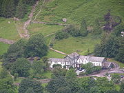
Old Dungeon Ghyll
The Old Dungeon Ghyll pub and hotel was originally a farm and inn. It was bought by the historian Professor G.M. Trevelyan who donated it to the National TrustNational Trust for Places of Historic Interest or Natural Beauty
The National Trust for Places of Historic Interest or Natural Beauty, usually known as the National Trust, is a conservation organisation in England, Wales and Northern Ireland...
. The hotel and the Hikers Bar have a long association with climbing
Climbing
Climbing is the activity of using one's hands and feet to ascend a steep object. It is done both for recreation and professionally, as part of activities such as maintenance of a structure, or military operations.Climbing activities include:* Bouldering: Ascending boulders or small...
and many famous climbers have stayed at the hotel or drank in the bar. In climbing circles it is known as the "ODG". Other places to stay include the New Dungeon Ghyll hotel, the National Trust campsite, Chapel Stile
campsite and the Stickle Barn bunkhouse.