
Pavey Ark
Encyclopedia
Pavey Ark is a fell
in the English
county of Cumbria
. It is one of the Langdale Pikes, lying to the north of Great Langdale
, in the heart of the Lake District
, immediately to the north-east of Harrison Stickle
.
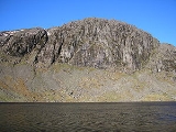
, Pavey Ark gives the impression of being a rocky ridge. In fact this is misleading, and the north-western side is simply an undulating area of moorland
, rising towards Thunacar Knott
. The summit plateau is characterised by tarns, rocky outcrops and bilberry
terraces.
Pavey Ark is the largest cliff in the Langdales, but faces east over Stickle Tarn
and is less prominent from the floor of Great Langdale away to the south. The main face is a little over a quarter of a mile across and drops about 400 ft. To the south west it merges into the crags of Harrison Stickle
, while the northern end peters out into the valley of Bright Beck. Stickle Tarn is wholly within the territory of the Ark, a corrie
tarn
which has been dammed to create additional capacity. The stone faced barage is low enough not to spoil the character of the pool, and the water is used for public consumption in the hotels and homes below. The tarn has a depth of around 50 ft.
and breccia
and is set within the Seathwaite Fell Formation of volcaniclastic sandstone with interbeds of tuff
, lapilli
-tuff, breccia and conglomerate.
up to Stickle Tarn
, which can also be reached via a much less popular and more strenuous path following the Dungeon Ghyll ravines. From Stickle Tarn there is a choice of routes; one of the most popular is to follow a diagonal slit on Pavey Ark's crag
gy south-eastern face. This route is known as Jack's Rake, and requires scrambling
. Alternative, easier, ascents are available on either side of the main crag.
Jack's Rake is the most famous ascent of the Pavey Ark precipice. It is classified as a Grade 1 scramble, but it is within the capability of many walkers, though it does require a head for heights and is considerably harder in bad weather. The rake starts beneath the East Buttress at the precipice's eastern end, near a large cairn
(with a tablet marked 'JWS 1900') immediately north of Stickle Tarn, and then climbs west across the face of the crag. The rake follows a natural groove in the precipice face and is clearly indicated by several Ash
trees. Wainwright
wrote that for fellwalkers Jack's Rake is "difficult and awkward", although there is "curiously little sense of exposure, for a comforting parapet of rock accompanies all the steeper parts of the ascent". The summit is a short walk from the top exit of the rake, which is also used as a descent route and by rockclimbers accessing the climbs on the cliff face.
As with Lord's Rake on Scafell Crag, the word 'rake' refers to a path across major precipices, originally used by climbers for access to rock climbs, but which can also be used by walkers.
Pavey Ark can also be ascended from Stickle Tarn via Easy Gully, North Rake or by the path to Harrison Stickle
. Easy Gully is a steep walk on scree
between the crags at the eastern end of the precipice, starting from the same place as Jack's Rake, and is blocked by large boulders near the top, where tough scrambling is required. North Rake (so named by Wainwright) starts from the path to High Raise at the very eastern end of the cliff and rises west over the top of the East Buttress. This is a much less exposed and strenuous walking route to the summit.
on the bare rock of the summit, set back a few yards from the edge and a little to the north of the exit from Jack's Rake. The view north west is perhaps spoilt by the long slopes of High Raise
, but the Eastern
and Southern Fells
are well seen
Fell
“Fell” is a word used to refer to mountains, or certain types of mountainous landscape, in Scandinavia, the Isle of Man, and parts of northern England.- Etymology :...
in the English
England
England is a country that is part of the United Kingdom. It shares land borders with Scotland to the north and Wales to the west; the Irish Sea is to the north west, the Celtic Sea to the south west, with the North Sea to the east and the English Channel to the south separating it from continental...
county of Cumbria
Cumbria
Cumbria , is a non-metropolitan county in North West England. The county and Cumbria County Council, its local authority, came into existence in 1974 after the passage of the Local Government Act 1972. Cumbria's largest settlement and county town is Carlisle. It consists of six districts, and in...
. It is one of the Langdale Pikes, lying to the north of Great Langdale
Great Langdale
Great Langdale is a valley in the Lake District National Park in the county of Cumbria, in the northwest of England. It is often simply referred to as Langdale, the epithet Great distinguishing it from the neighbouring valley of Little Langdale....
, in the heart of the Lake District
Lake District
The Lake District, also commonly known as The Lakes or Lakeland, is a mountainous region in North West England. A popular holiday destination, it is famous not only for its lakes and its mountains but also for its associations with the early 19th century poetry and writings of William Wordsworth...
, immediately to the north-east of Harrison Stickle
Harrison Stickle
Harrison Stickle is a fell in the central part of the English Lake District, situated above Great Langdale. The fell is one of the three fells which make up the picturesque Langdale Pikes, the others being Pike of Stickle and Loft Crag. Together they make up one of the most picturesque, and...
.
Topography
From the shores of Stickle TarnStickle Tarn
Stickle Tarn is a small tarn near Harrison Stickle in Lake District, England.The tarn was enlarged by the building of a stone dam in 1838 and is used to supply water for the inhabitants of Langdale....
, Pavey Ark gives the impression of being a rocky ridge. In fact this is misleading, and the north-western side is simply an undulating area of moorland
Moorland
Moorland or moor is a type of habitat, in the temperate grasslands, savannas, and shrublands biome, found in upland areas, characterised by low-growing vegetation on acidic soils and heavy fog...
, rising towards Thunacar Knott
Thunacar Knott
Thunacar Knott is a fell in the central part of the English Lake District in the county of Cumbria.-Topography:The main spine of the Central Fells runs south from Bleaberry Fell to High Raise, before turning sharply east en route for Blea Rigg and Loughrigg Fell. A secondary ridge projects...
. The summit plateau is characterised by tarns, rocky outcrops and bilberry
Bilberry
Bilberry is any of several species of low-growing shrubs in the genus Vaccinium , bearing edible berries. The species most often referred to is Vaccinium myrtillus L., but there are several other closely related species....
terraces.
Pavey Ark is the largest cliff in the Langdales, but faces east over Stickle Tarn
Stickle Tarn
Stickle Tarn is a small tarn near Harrison Stickle in Lake District, England.The tarn was enlarged by the building of a stone dam in 1838 and is used to supply water for the inhabitants of Langdale....
and is less prominent from the floor of Great Langdale away to the south. The main face is a little over a quarter of a mile across and drops about 400 ft. To the south west it merges into the crags of Harrison Stickle
Harrison Stickle
Harrison Stickle is a fell in the central part of the English Lake District, situated above Great Langdale. The fell is one of the three fells which make up the picturesque Langdale Pikes, the others being Pike of Stickle and Loft Crag. Together they make up one of the most picturesque, and...
, while the northern end peters out into the valley of Bright Beck. Stickle Tarn is wholly within the territory of the Ark, a corrie
Cirque
Cirque may refer to:* Cirque, a geological formation* Makhtesh, an erosional landform found in the Negev desert of Israel and Sinai of Egypt*Cirque , an album by Biosphere* Cirque Corporation, a company that makes touchpads...
tarn
Tarn (lake)
A tarn is a mountain lake or pool, formed in a cirque excavated by a glacier. A moraine may form a natural dam below a tarn. A corrie may be called a cirque.The word is derived from the Old Norse word tjörn meaning pond...
which has been dammed to create additional capacity. The stone faced barage is low enough not to spoil the character of the pool, and the water is used for public consumption in the hotels and homes below. The tarn has a depth of around 50 ft.
Geology
The face is an outcrop of the formation named for the fell, the Pavey Ark Member. This consists of pebbly sandstoneSandstone
Sandstone is a sedimentary rock composed mainly of sand-sized minerals or rock grains.Most sandstone is composed of quartz and/or feldspar because these are the most common minerals in the Earth's crust. Like sand, sandstone may be any colour, but the most common colours are tan, brown, yellow,...
and breccia
Breccia
Breccia is a rock composed of broken fragments of minerals or rock cemented together by a fine-grained matrix, that can be either similar to or different from the composition of the fragments....
and is set within the Seathwaite Fell Formation of volcaniclastic sandstone with interbeds of tuff
Tuff
Tuff is a type of rock consisting of consolidated volcanic ash ejected from vents during a volcanic eruption. Tuff is sometimes called tufa, particularly when used as construction material, although tufa also refers to a quite different rock. Rock that contains greater than 50% tuff is considered...
, lapilli
Lapilli
Lapilli is a size classification term for tephra, which is material that falls out of the air during a volcanic eruption or during some meteorite impacts. Lapilli means "little stones" in Latin. They are in some senses similar to ooids or pisoids in calcareous sediments.By definition lapilli range...
-tuff, breccia and conglomerate.
Ascents
Pavey Ark is most often climbed from the New Dungeon Ghyll Hotel, located some 1 ¼ miles (2 km) to the south. The route follows Mill GillGill (stream)
Ghyll or Gill is used for a stream or narrow valley in the North of England and other parts of the United Kingdom. The word originates from the Old Norse Gil...
up to Stickle Tarn
Tarn (lake)
A tarn is a mountain lake or pool, formed in a cirque excavated by a glacier. A moraine may form a natural dam below a tarn. A corrie may be called a cirque.The word is derived from the Old Norse word tjörn meaning pond...
, which can also be reached via a much less popular and more strenuous path following the Dungeon Ghyll ravines. From Stickle Tarn there is a choice of routes; one of the most popular is to follow a diagonal slit on Pavey Ark's crag
Cliff
In geography and geology, a cliff is a significant vertical, or near vertical, rock exposure. Cliffs are formed as erosion landforms due to the processes of erosion and weathering that produce them. Cliffs are common on coasts, in mountainous areas, escarpments and along rivers. Cliffs are usually...
gy south-eastern face. This route is known as Jack's Rake, and requires scrambling
Scrambling
Scrambling is a method of ascending rocky faces and ridges. It is an ambiguous term that lies somewhere between hillwalking and rock climbing. It is often distinguished from hillwalking by defining a scramble as a route where hands must be used in the ascent...
. Alternative, easier, ascents are available on either side of the main crag.
Jack's Rake is the most famous ascent of the Pavey Ark precipice. It is classified as a Grade 1 scramble, but it is within the capability of many walkers, though it does require a head for heights and is considerably harder in bad weather. The rake starts beneath the East Buttress at the precipice's eastern end, near a large cairn
Cairn
Cairn is a term used mainly in the English-speaking world for a man-made pile of stones. It comes from the or . Cairns are found all over the world in uplands, on moorland, on mountaintops, near waterways and on sea cliffs, and also in barren desert and tundra areas...
(with a tablet marked 'JWS 1900') immediately north of Stickle Tarn, and then climbs west across the face of the crag. The rake follows a natural groove in the precipice face and is clearly indicated by several Ash
European Ash
Fraxinus excelsior , is a species of Fraxinus native to most of Europe with the exception of northern Scandinavia and southern Iberia, and also southwestern Asia from northern Turkey east to the Caucasus and Alborz mountains...
trees. Wainwright
Alfred Wainwright
Alfred Wainwright MBE was a British fellwalker, guidebook author and illustrator. His seven-volume Pictorial Guide to the Lakeland Fells, published between 1955 and 1966 and consisting entirely of reproductions of his manuscript, has become the standard reference work to 214 of the fells of the...
wrote that for fellwalkers Jack's Rake is "difficult and awkward", although there is "curiously little sense of exposure, for a comforting parapet of rock accompanies all the steeper parts of the ascent". The summit is a short walk from the top exit of the rake, which is also used as a descent route and by rockclimbers accessing the climbs on the cliff face.
As with Lord's Rake on Scafell Crag, the word 'rake' refers to a path across major precipices, originally used by climbers for access to rock climbs, but which can also be used by walkers.
Pavey Ark can also be ascended from Stickle Tarn via Easy Gully, North Rake or by the path to Harrison Stickle
Harrison Stickle
Harrison Stickle is a fell in the central part of the English Lake District, situated above Great Langdale. The fell is one of the three fells which make up the picturesque Langdale Pikes, the others being Pike of Stickle and Loft Crag. Together they make up one of the most picturesque, and...
. Easy Gully is a steep walk on scree
Scree
Scree, also called talus, is a term given to an accumulation of broken rock fragments at the base of crags, mountain cliffs, or valley shoulders. Landforms associated with these materials are sometimes called scree slopes or talus piles...
between the crags at the eastern end of the precipice, starting from the same place as Jack's Rake, and is blocked by large boulders near the top, where tough scrambling is required. North Rake (so named by Wainwright) starts from the path to High Raise at the very eastern end of the cliff and rises west over the top of the East Buttress. This is a much less exposed and strenuous walking route to the summit.
Summit and view
There is no cairnCairn
Cairn is a term used mainly in the English-speaking world for a man-made pile of stones. It comes from the or . Cairns are found all over the world in uplands, on moorland, on mountaintops, near waterways and on sea cliffs, and also in barren desert and tundra areas...
on the bare rock of the summit, set back a few yards from the edge and a little to the north of the exit from Jack's Rake. The view north west is perhaps spoilt by the long slopes of High Raise
High Raise (Langdale)
High Raise is a fell in the Central Fells of the English Lake District not to be confused with another High Raise situated in the Far Eastern Fells...
, but the Eastern
Eastern Fells
The Eastern Fells are a group of hills in the English Lake District. Centred on Helvellyn they primarily comprise a north south ridge running between Ullswater and Lakeland's Central Valley.-Partition of the Lakeland Fells:...
and Southern Fells
Southern Fells
Image:Annotated Scafell range.jpg|thumb|300px|The Scafellsrect 23 372 252 419 Slight Side rect 173 794 560 834 Scafell East Buttressrect 707 787 893 861 Esk Pike or Crag rect 245 303 409 358 Sca Fell rect 408 238 637 280 Mickledore Image:Annotated Scafell range.jpg|thumb|300px|The Scafellsrect 23...
are well seen