
Gilgit District
Encyclopedia
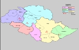
Gilgit District is one of the districts of the federal territory of Gilgit-Baltistan in northern Pakistan
. It was formed in 1970 when Gilgit-Baltistan was federally administered as the "Northern Areas". It is bounded by the Wakhan Corridor
(Afghanistan
) to the north; Xinjiang
(China
) to the northeast and east; Skardu
, Astore
and Diamer
to the south; and Ghizar District to the west. The town of Gilgit
is the capital of Gilgit District. According to the 1998 census Gilgit District had a population of 243,324.
The district includes Gilgit town
, Gojal
(Upper Hunza), Hunza
, Juglot
, Naltar
, Nomal, and Shimshal
. It also includes many small villages like Minapin, Hope and Hispar
etc. The highest peak in the district is Distaghil Sar
(7,885m) which is the seventh highest peak in Pakistan
and 19th highest on earth
.
ghazanfar ali shah, who is the constitutional head of provincial government, assisted an executive Chief Minister
fatah ali khan and a council of ministers.
Administered by a tailor-made political and local government system. The local government system is based on a Legislative Council (Provincial Assembly), elected by people in all six districts through voting, headed by a speaker. Technocrats and women members are later elected/selected through a proper system.
Chief Secretary is administrative head of all departments, controlling all the affairs on behalf of chief minister Government of Pakistan
.
Inspector General of Police, currently mr.Husain Asghar, heads the police department, with deputy superintendents in all six districts.
, composed of three judges selected by the government, supported by the Supreme Appellate Court.
,i.e. Gilgit Valley
is included within the political boundaries of Gilgit District. There is an intervening width of mountainous country, represented chiefly by glacier
s and ice field
s, and intersected by narrow sterile valleys, measuring some 100 metres (328.1 ft) to 150 metres (492.1 ft) in width, to the north and north-east, which separates the province of Gilgit from the Chinese frontier beyond the Muztagh
and Karakoram
. Towering above Gilgit is Mount Rakaposhi
at 7788 metres (25,551.2 ft).
There are many tributaries of the above main rivers, some of which are Ghujerab River, Shimshal River, Hispar River
, Naltar River and Yaheen River.
Pakistan
Pakistan , officially the Islamic Republic of Pakistan is a sovereign state in South Asia. It has a coastline along the Arabian Sea and the Gulf of Oman in the south and is bordered by Afghanistan and Iran in the west, India in the east and China in the far northeast. In the north, Tajikistan...
. It was formed in 1970 when Gilgit-Baltistan was federally administered as the "Northern Areas". It is bounded by the Wakhan Corridor
Wakhan Corridor
Wakhan Corridor is commonly used as a synonym for Wakhan, an area of far north-eastern Afghanistan which forms a land link or "corridor" between Afghanistan and China. The Corridor is a long and slender panhandle or salient, roughly long and between wide. It separates Tajikistan in the north...
(Afghanistan
Afghanistan
Afghanistan , officially the Islamic Republic of Afghanistan, is a landlocked country located in the centre of Asia, forming South Asia, Central Asia and the Middle East. With a population of about 29 million, it has an area of , making it the 42nd most populous and 41st largest nation in the world...
) to the north; Xinjiang
Xinjiang
Xinjiang is an autonomous region of the People's Republic of China. It is the largest Chinese administrative division and spans over 1.6 million km2...
(China
China
Chinese civilization may refer to:* China for more general discussion of the country.* Chinese culture* Greater China, the transnational community of ethnic Chinese.* History of China* Sinosphere, the area historically affected by Chinese culture...
) to the northeast and east; Skardu
Skardu District
Skardu District is part of Baltistan and currently constitutes one of the seven districts of the Gilgit-Baltistan territory of Pakistan...
, Astore
Astore District
Astore is one of the six districts of the Gilgit Baltistan. The district contains the Astore Valley and is bounded to the west by Diamer District , to the north by Gilgit District, to the east by Skardu District and to the south by Khyber-Pakhtunkhwa and Neelum District of Azad Kashmir...
and Diamer
Diamer District
Diamer District is one of the seven districts of the Northern Areas of Pakistan. It is the district in which the Karakoram Highway enters that territory from the North-West Frontier Province, the capital of the district is Chilas...
to the south; and Ghizar District to the west. The town of Gilgit
Gilgit
Gilgit is a city in northern PakistanGilgit may refer to other terms related with the area of the city:* Gilgit River* Gilgit Valley* Gilgit District* Gilgit Agency * Gilgit Airport...
is the capital of Gilgit District. According to the 1998 census Gilgit District had a population of 243,324.
The district includes Gilgit town
Gilgit
Gilgit is a city in northern PakistanGilgit may refer to other terms related with the area of the city:* Gilgit River* Gilgit Valley* Gilgit District* Gilgit Agency * Gilgit Airport...
, Gojal
Gojal
Gojal, also known as Upper Hunza, is an area north of Gilgit in the far north of Pakistan near the Chinese and Afghan borders. It is the largest tehsil of the Gilgit-Baltistan autonomous area of northern Pakistan....
(Upper Hunza), Hunza
Hunza (princely state)
Hunza was a princely state in the northernmost part of the Northern Areas of Pakistan until 1974. The state was also known as Kanjut. The state bordered the Gilgit Agency to the south, the former princely state of Nagar to the east, China, to the north and Afghanistan to the northwest. The state...
, Juglot
Juglot
Juglot or Jaglot is a town in Gilgit District Pakistan, situated 45 km south east of Gilgit on the Karakoram Highway. It is located on the junction of three mighty mountain ranges, the Kurrakuram, Hindukush and Himalayas. It is also a junction point between Skardu and Gilgit. The road to...
, Naltar
Naltar
Naltar is a valley near Gilgit and Hunza in the Gilgit-Baltistan region of Pakistan. Naltar is 40 km from Gilgit and can be reached by jeeps. Naltar is a forested village known for its wildlife and magnificent mountain scenery. Now the communication is available by the efforts of Pakistan army...
, Nomal, and Shimshal
Shimshal
Shimshal شمشال is a beautiful village located in Gojal, Hunza-Nagar District, in the Pakistan-administered Gilgit-Baltistan formerly known as Northern Areas of Pakistan. It lies at an altitude of 3,200 m above sea level, and is the highest settlement in Hunza Valley of Pakistan...
. It also includes many small villages like Minapin, Hope and Hispar
Hispar
Hispar is a village two kilometers below the snout of the 49 kilometer-long Hispar Glacier. It can be reached from the Karakoram Highway by the road that leads south of Hunza towards Nagar , Hopar and Hispar, though in August 2006 this road was washed out at the confluence of the Hispar and Hunza...
etc. The highest peak in the district is Distaghil Sar
Distaghil Sar
Disteghil Sar or Distaghil Sar is the highest mountain in the Hispar Muztagh, a subrange of the Karakoram mountain range, in Gilgit-Baltistan. It is the 19th highest mountain on earth and the 7th highest peak in Pakistan...
(7,885m) which is the seventh highest peak in Pakistan
Pakistan
Pakistan , officially the Islamic Republic of Pakistan is a sovereign state in South Asia. It has a coastline along the Arabian Sea and the Gulf of Oman in the south and is bordered by Afghanistan and Iran in the west, India in the east and China in the far northeast. In the north, Tajikistan...
and 19th highest on earth
Earth
Earth is the third planet from the Sun, and the densest and fifth-largest of the eight planets in the Solar System. It is also the largest of the Solar System's four terrestrial planets...
.
Administration
The Government of Pakistan has recently changed the status of the Northern Areas through a constitutional order and has renamed it as the defacto province of Gilgit-Baltistan. The ceremonial head is the GovernorGovernor
A governor is a governing official, usually the executive of a non-sovereign level of government, ranking under the head of state...
ghazanfar ali shah, who is the constitutional head of provincial government, assisted an executive Chief Minister
Chief Minister
A Chief Minister is the elected head of government of a sub-national state, provinces of Sri Lanka, Pakistan, notably a state of India, a territory of Australia or a British Overseas Territory that has attained self-government...
fatah ali khan and a council of ministers.
Administered by a tailor-made political and local government system. The local government system is based on a Legislative Council (Provincial Assembly), elected by people in all six districts through voting, headed by a speaker. Technocrats and women members are later elected/selected through a proper system.
Chief Secretary is administrative head of all departments, controlling all the affairs on behalf of chief minister Government of Pakistan
Government of Pakistan
The Government of Pakistan is a federal parliamentary system, with an indirectly-elected President as the Head of State and Commander in Chief of the Pakistani Armed Forces, and an indirectly-elected Prime Minister as the Head of Government. The President’s appointment and term are...
.
Inspector General of Police, currently mr.Husain Asghar, heads the police department, with deputy superintendents in all six districts.
Judiciary
The main judivial structure in Gilgit-Baltistan comprises a High CourtHigh Court
The term High Court usually refers to the superior court of a country or state. In some countries, it is the highest court . In others, it is positioned lower in the hierarchy of courts The term High Court usually refers to the superior court (or supreme court) of a country or state. In some...
, composed of three judges selected by the government, supported by the Supreme Appellate Court.
Geography
Only a part of the basin of the Gilgit RiverGilgit River
Gilgit River is a tributary of the Indus River, and flows past the town of Gilgit. It is located in the Northern Areas of Gilgit-Baltistan, Pakistan. The Gilgit starts from Shandur lake. The Gilgit River is also referred to as the Ghizar River....
,i.e. Gilgit Valley
Gilgit Valley
Gilgit Valley is located in Gilgit, Pakistan. The Gilgit River flows here. 375 km of road connect it to Chitral via the Shandur Pass ....
is included within the political boundaries of Gilgit District. There is an intervening width of mountainous country, represented chiefly by glacier
Glacier
A glacier is a large persistent body of ice that forms where the accumulation of snow exceeds its ablation over many years, often centuries. At least 0.1 km² in area and 50 m thick, but often much larger, a glacier slowly deforms and flows due to stresses induced by its weight...
s and ice field
Ice field
An ice field is an area less than 50,000 km² of ice often found in the colder climates and higher altitudes of the world where there is sufficient precipitation. It is an extensive area of interconnected valley glaciers from which the higher peaks rise as nunataks...
s, and intersected by narrow sterile valleys, measuring some 100 metres (328.1 ft) to 150 metres (492.1 ft) in width, to the north and north-east, which separates the province of Gilgit from the Chinese frontier beyond the Muztagh
Muztagh
Muztagh may refer to:The Greater Karakoram ranges*Baltoro Muztagh*Batura Muztagh*Hispar Muztagh*Panmah Muztagh*Rimo Muztagh*Saser Muztagh*Siachen MuztaghTwo mountain passes in the Karakoram, the western and the eastern*Mustagh PassesThe Mountains...
and Karakoram
Karakoram
The Karakoram, or Karakorum , is a large mountain range spanning the borders between Pakistan, India and China, located in the regions of Gilgit-Baltistan , Ladakh , and Xinjiang region,...
. Towering above Gilgit is Mount Rakaposhi
Rakaposhi
Rakaposhi , is a mountain in the Karakoram mountain range in Pakistan. It is situated in the Nagar Valley approximately 100 km north of the city of Gilgit in the Gilgit District of the Gilgit-Baltistan province of Pakistan. Rakaposhi means "Snow Covered" in the local language. Rakaposhi is...
at 7788 metres (25,551.2 ft).
Rivers in Gilgit District
The main rivers in the District are:- Khunjerab River - flows south along the Karakoram HighwayKarakoram HighwayThe Karakoram Highway is the highest paved international road in the world, but at its peak at the China-Pakistan border it is only paved on the Chinese side. It connects China and Pakistan across the Karakoram mountain range, through the Khunjerab Pass, at an altitude of as confirmed by both...
from the Khunjerab Valley, known as Hunza RiverHunza RiverHunza River is the principal river of Hunza, in the Northern Areas of Pakistan. It is formed by the confluence of the Kilik and Khunjerab nalas which are fed by glaciers. It is joined by the Gilgit River and the Naltar River before it flows into the Indus River.The river cuts through the...
in the south of SustSustSust or Sost is a dry port in Gojal region of the Northern Areas of Pakistan. It is the last town inside Pakistan on the Karakoram Highway before the Chinese border... - Hunza RiverHunza RiverHunza River is the principal river of Hunza, in the Northern Areas of Pakistan. It is formed by the confluence of the Kilik and Khunjerab nalas which are fed by glaciers. It is joined by the Gilgit River and the Naltar River before it flows into the Indus River.The river cuts through the...
- flows further south and falls into Gilgit RiverGilgit RiverGilgit River is a tributary of the Indus River, and flows past the town of Gilgit. It is located in the Northern Areas of Gilgit-Baltistan, Pakistan. The Gilgit starts from Shandur lake. The Gilgit River is also referred to as the Ghizar River....
just in the northeast of GilgitGilgitGilgit is a city in northern PakistanGilgit may refer to other terms related with the area of the city:* Gilgit River* Gilgit Valley* Gilgit District* Gilgit Agency * Gilgit Airport...
town - Gilgit RiverGilgit RiverGilgit River is a tributary of the Indus River, and flows past the town of Gilgit. It is located in the Northern Areas of Gilgit-Baltistan, Pakistan. The Gilgit starts from Shandur lake. The Gilgit River is also referred to as the Ghizar River....
- enters Gilgit District from west in the south of Bichhar PassBichhar PassBichhar pass is a high mountain pass at the boundary of the Ghizer and Gilgit districts in the Northern Areas of Pakistan. To the north of the pass is Bichhari village in the Naltar valley in Gilgit district. To the south of the pass is the village Sherqila on the Gilgit river in the Ghizer...
(Naltar Valley) and flows west through the Gilgit town. - Indus RiverIndus RiverThe Indus River is a major river which flows through Pakistan. It also has courses through China and India.Originating in the Tibetan plateau of western China in the vicinity of Lake Mansarovar in Tibet Autonomous Region, the river runs a course through the Ladakh district of Jammu and Kashmir and...
- enters Gilgit District from Skardu DistrictSkardu DistrictSkardu District is part of Baltistan and currently constitutes one of the seven districts of the Gilgit-Baltistan territory of Pakistan...
about six kilometers north of Jaglot where Gilgit RiverGilgit RiverGilgit River is a tributary of the Indus River, and flows past the town of Gilgit. It is located in the Northern Areas of Gilgit-Baltistan, Pakistan. The Gilgit starts from Shandur lake. The Gilgit River is also referred to as the Ghizar River....
falls into Indus RiverIndus RiverThe Indus River is a major river which flows through Pakistan. It also has courses through China and India.Originating in the Tibetan plateau of western China in the vicinity of Lake Mansarovar in Tibet Autonomous Region, the river runs a course through the Ladakh district of Jammu and Kashmir and...
and the Indus flows south along the Karakoram Highway.- Astor River
There are many tributaries of the above main rivers, some of which are Ghujerab River, Shimshal River, Hispar River
Hispar River
The Hispar River forms from the melt water of the Hispar Glacier - a 49 kilometer-long glacier in the Northern Areas of Pakistan's Karakoram Mountains. The Hispar Glacier and river both flow northwest, passing through Hispar, Hopar and Nagar villages until the confluence with the Hunza River in...
, Naltar River and Yaheen River.
Passes in Gilgit District
- Khunjerab PassKhunjerab PassKhunjerab Pass is a high mountain pass in the Karakoram Mountains in a strategic position on the northern border of Pakistan's Gilgit-Baltistan region within the disputed region of Kashmir and on the southwest border of the Xinjiang region of China...
, Mintika Pass, Kilik PassKilik PassThe Kilik Pass , to the west of Mintaka Pass is a high mountain pass in the Karakorum Mountains between Pakistan-administered Kashmir and Xinjiang in the People's Republic of China. The two passes were, in ancient times, the two main access points into the Upper Hunza Valley from the north...
, Chillingi Pass, Shimshal Pass, Ghujerab Pass, Chapchingal Pass, Chaprot PassChaprot PassChaprot Pass is a mountain pass to the northeast of Mehrbani Peak in the northwest of Chaprot.-External links:*...
, Naltar PassNaltar PassNaltar Pass is a mountain pass to the north of Shani Peak in Naltar Valley in Pakistan. The pass lies west of Chaprot Pass and east of Hayal Pass.-External links:*...
and Talmutz Pass.
Lakes in Gilgit District
- Naltar Lakes
- Borit Lake
- Rush LakeRush Lake (Pakistan)Rush Lake is a high altitude lake located near Rush Pari Peak . At over 4,694 meters, Rush is one of the highest alpine lakes in the world. It is located about 15 km north of Miar Peak and Spantik , which are in the Nagar valley...
(Rush Peak) - Pahote Lake