

List of highest mountains
Encyclopedia
The following is a list of the world's 100+ highest mountain
Mountain
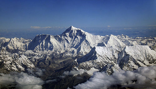
Image:Himalaya_annotated.jpg|thumb|right|The Himalayan mountain range with Mount Everestrect 58 14 160 49 Chomo Lonzorect 200 28 335 52 Makalurect 378 24 566 45 Mount Everestrect 188 581 920 656 Tibetan Plateaurect 250 406 340 427 Rong River...
s per height above sea level (>7200 metres (23,622 ft)), all of which are located in central and southern Asia
Asia
Asia is the world's largest and most populous continent, located primarily in the eastern and northern hemispheres. It covers 8.7% of the Earth's total surface area and with approximately 3.879 billion people, it hosts 60% of the world's current human population...
. Only those summit
Summit (topography)
In topography, a summit is a point on a surface that is higher in elevation than all points immediately adjacent to it. Mathematically, a summit is a local maximum in elevation...
s are included that, by an objective measure, may be considered individual mountains as opposed to subsidiary peak
Summit (topography)
In topography, a summit is a point on a surface that is higher in elevation than all points immediately adjacent to it. Mathematically, a summit is a local maximum in elevation...
s.
Considerations

Highest unclimbed mountain
The highest unclimbed mountain in a particular region or in the world is often a matter of controversy. In some parts of the world surveying and mapping are still not reliable, and there are not comprehensive records of the routes of explorers, mountaineers and local inhabitants.However, a major...
). A popular and intuitive way to distinguish mountains from subsidiary peaks is by their height above the highest saddle connecting it to a higher summit, a measure called topographic prominence
Topographic prominence
In topography, prominence, also known as autonomous height, relative height, shoulder drop , or prime factor , categorizes the height of the mountain's or hill's summit by the elevation between it and the lowest contour line encircling it and no higher summit...
or re-ascent (the higher summit is called the "parent peak"). A common definition of a mountain is a summit with 300 m (984.3 ft) prominence. Alternatively, a relative prominence (prominence/height) is used (usually 7-8%) to reflect that in higher mountain ranges everything is on a larger scale. The table below lists the highest 100 summits with at least 500 m (1,640.4 ft) prominence, approximating a 7% relative prominence. A drawback of a prominence-based list is that it may exclude well-known or spectacular mountains that are connected via a high ridge to a taller summit, like the Eiger
Eiger
The Eiger is a mountain in the Bernese Alps in Switzerland. It is the easternmost peak of a ridge crest that extends across the Mönch to the Jungfrau at 4,158 m...
or Nuptse
Nuptse
Nuptse is a mountain in the Khumbu region of the Mahalangur Himal, in the Nepalese Himalayas. It lies two kilometres WSW of Mount Everest. Nuptse is Tibetan for "west peak", as it is the western segment of the Lhotse-Nuptse massif....
. A few such peaks and mountains with nearly sufficient prominence are included but not numbered in this list.
It is very unlikely that all given heights are correct to the nearest metre; indeed, the sea level is often problematic to define when a mountain is remote from the sea. Different sources often differ by many metres, and the heights given below may well differ from those elsewhere in this encyclopedia. As an extreme example, Ulugh Muztagh
Ulugh Muztagh
Ulugh Muztagh or Ulugh Muztag and Muztag Feng , is an extremely remote mountain group on the northern Qinghai-Tibetan Plateau. Located on the border between the Tibetan Autonomous Region and Xinjiang Uyghur Autonomous Region, it is part of the main range of the Kunlun Mountains of East-Central...
on the north Tibetan Plateau
Tibetan Plateau
The Tibetan Plateau , also known as the Qinghai–Tibetan Plateau is a vast, elevated plateau in Central Asia covering most of the Tibet Autonomous Region and Qinghai, in addition to smaller portions of western Sichuan, southwestern Gansu, and northern Yunnan in Western China and Ladakh in...
is often listed as 7723 m (25,338 ft) to 7754 m (25,440 ft), but appears to be only 6973 m (22,877 ft) to 6987 m (22,923 ft). Some mountains differ by > 100 m (328.1 ft) on different maps, while even very thorough current measurements of Mount Everest range from 8840 m (29,003 ft) to 8850 m (29,035 ft). These discrepancies serve to emphasize the uncertainties in the listed heights.
Though some parts of the world, especially the most mountainous parts, have never been thoroughly mapped, it is unlikely that any mountains this high have been overlooked, because synthetic aperture radar
Synthetic aperture radar
Synthetic-aperture radar is a form of radar whose defining characteristic is its use of relative motion between an antenna and its target region to provide distinctive long-term coherent-signal variations that are exploited to obtain finer spatial resolution than is possible with conventional...
can and has been used to measure altitudes of most otherwise inaccessible places. Still, heights and/or prominences may be revised, so that the order of the list may change and even "new" mountains could enter the list over time. To be safe, the list has been extended to include all >7200 m (23,622 ft) peaks.
The highest mountains above sea level are generally not the highest above the surrounding terrain. There is no precise definition of surrounding base, but Mount McKinley
Mount McKinley
Mount McKinley or Denali in Alaska, United States is the highest mountain peak in North America and the United States, with a summit elevation of above sea level. It is the centerpiece of Denali National Park and Preserve.- Geology and features :Mount McKinley is a granitic pluton...
, Mount Kilimanjaro
Mount Kilimanjaro
Kilimanjaro, with its three volcanic cones, Kibo, Mawenzi, and Shira, is a dormant volcano in Kilimanjaro National Park, Tanzania and the highest mountain in Africa at above sea level .-Geology:...
and Nanga Parbat
Nanga Parbat
Nanga Parbat is the ninth highest mountain on Earth, the second highest mountain in Pakistan and among the eight-thousanders with a summit elevation of 8,126 meters...
are possible candidates for the tallest mountain on land by this measure. The bases of mountain islands are below sea level, and given this consideration Mauna Kea
Mauna Kea
Mauna Kea is a volcano on the island of Hawaii. Standing above sea level, its peak is the highest point in the state of Hawaii. However, much of the mountain is under water; when measured from its oceanic base, Mauna Kea is over tall—significantly taller than Mount Everest...
(4207 m (13,802 ft) above sea level) is the world
World
World is a common name for the whole of human civilization, specifically human experience, history, or the human condition in general, worldwide, i.e. anywhere on Earth....
's tallest mountain and volcano
Volcano
2. Bedrock3. Conduit 4. Base5. Sill6. Dike7. Layers of ash emitted by the volcano8. Flank| 9. Layers of lava emitted by the volcano10. Throat11. Parasitic cone12. Lava flow13. Vent14. Crater15...
, rising about 10203 m (33,474 ft) from the Pacific Ocean
Pacific Ocean
The Pacific Ocean is the largest of the Earth's oceanic divisions. It extends from the Arctic in the north to the Southern Ocean in the south, bounded by Asia and Australia in the west, and the Americas in the east.At 165.2 million square kilometres in area, this largest division of the World...
floor. Ojos del Salado
Ojos del Salado
Nevado Ojos del Salado is a massive stratovolcano in the Andes on the Argentina-Chile border and the highest volcano in the world at . It is also the second highest mountain in the Western Hemisphere and Southern Hemisphere and the highest in Chile...
has the greatest rise on Earth
Earth
Earth is the third planet from the Sun, and the densest and fifth-largest of the eight planets in the Solar System. It is also the largest of the Solar System's four terrestrial planets...
— 13420 m (44,029 ft) from the summit to the bottom of the Atacama Trench about 560 km (348 mi) away, though most of this rise is not part of the mountain.
The highest mountains are also not generally the most voluminous. Mauna Loa
Mauna Loa
Mauna Loa is one of five volcanoes that form the Island of Hawaii in the U.S. state of Hawaii in the Pacific Ocean, and the largest on Earth in terms of volume and area covered. It is an active shield volcano, with a volume estimated at approximately , although its peak is about lower than that...
(4169 m (13,678 ft)) is the largest mountain on Earth in terms of base area (about 2000 sq mi (5,180 km²)) and volume (about 10000 cu mi (41,681.8 km³)), although, due to the intergrade of lava
Lava
Lava refers both to molten rock expelled by a volcano during an eruption and the resulting rock after solidification and cooling. This molten rock is formed in the interior of some planets, including Earth, and some of their satellites. When first erupted from a volcanic vent, lava is a liquid at...
from Kilauea
Kilauea
Kīlauea is a volcano in the Hawaiian Islands, and one of five shield volcanoes that together form the island of Hawaii. Kīlauea means "spewing" or "much spreading" in the Hawaiian language, referring to its frequent outpouring of lava. The Puu Ōō cone has been continuously erupting in the eastern...
, Hualalai
Hualalai
Hualālai is a dormant shield volcano on the island of Hawaii in the Hawaiian Islands. It is the third-youngest and the third most active of the five volcanoes that form the island of Hawaii, following Kīlauea and the much larger Mauna Loa, and also the westernmost. Its peak is above sea...
and Mauna Kea
Mauna Kea
Mauna Kea is a volcano on the island of Hawaii. Standing above sea level, its peak is the highest point in the state of Hawaii. However, much of the mountain is under water; when measured from its oceanic base, Mauna Kea is over tall—significantly taller than Mount Everest...
, the volume can only be estimated based on surface area and height of the edifice). Mt. Kilimanjaro is the largest non-shield volcano in terms of both base area (245 sq mi (635 km²)) and volume (1150 cu mi (4,793 km³)). Mount Logan
Mount Logan
Mount Logan is the highest mountain in Canada and the second-highest peak in North America, after Mount McKinley . The mountain was named after Sir William Edmond Logan, a Canadian geologist and founder of the Geological Survey of Canada . Mount Logan is located within Kluane National Park and...
is the largest non-volcanic mountain in base area (120 sq mi (311 km²)).
The highest mountains above sea level are also not those with peaks farthest from the centre of the Earth, because the figure of the Earth
Figure of the Earth
The expression figure of the Earth has various meanings in geodesy according to the way it is used and the precision with which the Earth's size and shape is to be defined. The actual topographic surface is most apparent with its variety of land forms and water areas. This is, in fact, the surface...
is not spherical. Sea level closer to the equator is several miles farther from the centre of the Earth. The summit of Chimborazo
Chimborazo (volcano)
Chimborazo is a currently inactive stratovolcano located in the Cordillera Occidental range of the Andes. Its last known eruption is believed to have occurred around 550 AD....
, Ecuador
Ecuador
Ecuador , officially the Republic of Ecuador is a representative democratic republic in South America, bordered by Colombia on the north, Peru on the east and south, and by the Pacific Ocean to the west. It is one of only two countries in South America, along with Chile, that do not have a border...
's tallest mountain, is usually considered to be the farthest point from the Earth's centre, although the southern summit of Peru
Peru
Peru , officially the Republic of Peru , is a country in western South America. It is bordered on the north by Ecuador and Colombia, on the east by Brazil, on the southeast by Bolivia, on the south by Chile, and on the west by the Pacific Ocean....
's tallest mountain, Huascarán
Huascarán
Huascarán or Nevado Huascarán is a mountain in the Peruvian province of Yungay, situated in the Cordillera Blanca range of the Western Andes. The highest southern summit of Huascarán is the highest point in Peru, and all the Earth's Tropics...
, is another contender. Both have elevations above sea level more than 2km less than that of Everest.
Geographical distribution
Most mountains in the list are located in the Himalaya and KarakoramKarakoram
The Karakoram, or Karakorum , is a large mountain range spanning the borders between Pakistan, India and China, located in the regions of Gilgit-Baltistan , Ladakh , and Xinjiang region,...
ranges. In fact, all 7000 m (22,965.9 ft) peaks in the world are located in the centre of Asia
Asia
Asia is the world's largest and most populous continent, located primarily in the eastern and northern hemispheres. It covers 8.7% of the Earth's total surface area and with approximately 3.879 billion people, it hosts 60% of the world's current human population...
(East Asia
East Asia
East Asia or Eastern Asia is a subregion of Asia that can be defined in either geographical or cultural terms...
, Central Asia
Central Asia
Central Asia is a core region of the Asian continent from the Caspian Sea in the west, China in the east, Afghanistan in the south, and Russia in the north...
and South Asia
South Asia
South Asia, also known as Southern Asia, is the southern region of the Asian continent, which comprises the sub-Himalayan countries and, for some authorities , also includes the adjoining countries to the west and the east...
) in a rectangle edged by Noshaq
Noshaq
Noshaq is the highest mountain in Afghanistan and the second highest independent peak of the Hindu Kush after Tirich Mir . Noshaq is located in the northeastern corner of the country along the Durand line which marks the border with Pakistan. It is the westernmost peak in the world...
(7492 m (24,580 ft)) on the Afghanistan
Afghanistan
Afghanistan , officially the Islamic Republic of Afghanistan, is a landlocked country located in the centre of Asia, forming South Asia, Central Asia and the Middle East. With a population of about 29 million, it has an area of , making it the 42nd most populous and 41st largest nation in the world...
-Pakistan
Pakistan
Pakistan , officially the Islamic Republic of Pakistan is a sovereign state in South Asia. It has a coastline along the Arabian Sea and the Gulf of Oman in the south and is bordered by Afghanistan and Iran in the west, India in the east and China in the far northeast. In the north, Tajikistan...
border in the West, Peak Jengish Chokusu, (Tuōmù'ěr Fēng) (7439 m (24,406 ft)) on the Kyrgyzstan
Kyrgyzstan
Kyrgyzstan , officially the Kyrgyz Republic is one of the world's six independent Turkic states . Located in Central Asia, landlocked and mountainous, Kyrgyzstan is bordered by Kazakhstan to the north, Uzbekistan to the west, Tajikistan to the southwest and China to the east...
- Xinjiang
Xinjiang
Xinjiang is an autonomous region of the People's Republic of China. It is the largest Chinese administrative division and spans over 1.6 million km2...
border to the North, Gongga Shan
Gongga Shan
Mount Gongga , also known as Minya Konka, is the highest mountain in Sichuan, China. It is situated in the Daxue Shan mountain range, part of the Hengduan mountainous region...
(Minya Konka) (7556 m (24,790 ft)) in Sichuan
Sichuan
' , known formerly in the West by its postal map spellings of Szechwan or Szechuan is a province in Southwest China with its capital in Chengdu...
to the East, and Kabru
Kabru
Kabru is a mountain in the Himalayas on the border of India and eastern Nepal. It is part of a ridge that extends south from Kangchenjunga.The main features of this ridge are as follows :* Kangchenjunga south top, 8476 m, at...
(7412 m (24,318 ft)) on the Sikkim
Sikkim
Sikkim is a landlocked Indian state nestled in the Himalayan mountains...
- Nepal
Nepal
Nepal , officially the Federal Democratic Republic of Nepal, is a landlocked sovereign state located in South Asia. It is located in the Himalayas and bordered to the north by the People's Republic of China, and to the south, east, and west by the Republic of India...
border to the South.
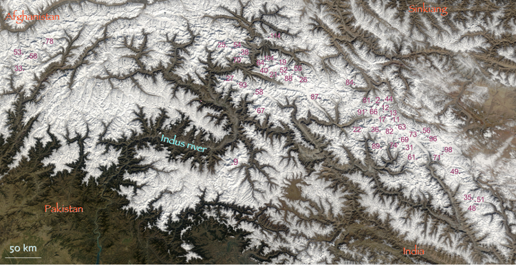
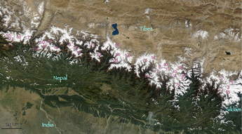
The locations of the highest mountains are shown on the composite satellite image of High Asia below. The numbers refer to the ranking in the list. For clarity, lower peaks with labels overlapping higher peaks are left out of the main image. The boxed regions are those with the highest density of summits and are enlarged in two separate images to show all peaks.

The list
| Rank | Mountain | Height (m) | Height (ft) | Range | Coordinates | Prominence (m) | Parent mountain | First ascent | Ascents (attempts) bef.2004 |
|---|---|---|---|---|---|---|---|---|---|
| 1 | Mount Everest Mount Everest Mount Everest is the world's highest mountain, with a peak at above sea level. It is located in the Mahalangur section of the Himalayas. The international boundary runs across the precise summit point... / Sagarmatha / Chomolungma |
8,848 | 29,029 | Mahalangur Mahalangur Himal Mahālangūr Himāl is a section of the Himalaya in northeast Nepal and south-central Tibet extending from the pass Nangpa La between Rolwaling Himal and Cho Oyu east to the Arun River. It includes Mount Everest, Lhotse, Makalu, and Cho Oyu) -- four of Earth's six highest peaks... Himalaya |
27°59′17"N 86°55′31"E | 8,848 | none | 1953 | >>145 (121) |
| 2 | K2 K2 K2 is the second-highest mountain on Earth, after Mount Everest... / Qogir / Godwin Austen |
8,611 | 28,251 | Baltoro Baltoro Muztagh The Baltoro Muztagh is a subrange of the Karakoram mountain range, in Baltistan region of the Gilgit-Baltistan province in northern Pakistan; and in Xinjiang, China. The crest of the range forms part of the Pakistan-China border.... Karakoram Karakoram The Karakoram, or Karakorum , is a large mountain range spanning the borders between Pakistan, India and China, located in the regions of Gilgit-Baltistan , Ladakh , and Xinjiang region,... |
35°52′53"N 76°30′48"E | 4,017 | Mount Everest Mount Everest Mount Everest is the world's highest mountain, with a peak at above sea level. It is located in the Mahalangur section of the Himalayas. The international boundary runs across the precise summit point... |
1954 | 45 (44) |
| 3 | Kangchenjunga Kangchenjunga Kangchenjunga is the third highest mountain of the world with an elevation of and located along the India-Nepal border in the Himalayas.Kangchenjunga is also the name of the section of the Himalayas and means "The Five Treasures of Snows", as it contains five peaks, four of them over... |
8,586 | 28,169 | Kangchenjunga Kangchenjunga Kangchenjunga is the third highest mountain of the world with an elevation of and located along the India-Nepal border in the Himalayas.Kangchenjunga is also the name of the section of the Himalayas and means "The Five Treasures of Snows", as it contains five peaks, four of them over... Himalaya |
27°42′12"N 88°08′51"E * | 3,922 | Mount Everest Mount Everest Mount Everest is the world's highest mountain, with a peak at above sea level. It is located in the Mahalangur section of the Himalayas. The international boundary runs across the precise summit point... |
1955 | 38 (24) |
| 4 | Lhotse Lhotse Lhotse is the fourth highest mountain on Earth and is connected to Everest via the South Col. In addition to the main summit at 8,516 metres above sea level, Lhotse Middle is and Lhotse Shar is... |
8,516 | 27,940 | Mahalangur Mahalangur Himal Mahālangūr Himāl is a section of the Himalaya in northeast Nepal and south-central Tibet extending from the pass Nangpa La between Rolwaling Himal and Cho Oyu east to the Arun River. It includes Mount Everest, Lhotse, Makalu, and Cho Oyu) -- four of Earth's six highest peaks... Himalaya |
27°57′42"N 86°55′59"E | 610 | Mount Everest Mount Everest Mount Everest is the world's highest mountain, with a peak at above sea level. It is located in the Mahalangur section of the Himalayas. The international boundary runs across the precise summit point... |
1956 | 26 (26) |
| 5 | Makalu Makalu Makalu is the fifth highest mountain in the world at and is located southeast of Mount Everest, on the border between Nepal and China... |
8,485 | 27,838 | Mahalangur Mahalangur Himal Mahālangūr Himāl is a section of the Himalaya in northeast Nepal and south-central Tibet extending from the pass Nangpa La between Rolwaling Himal and Cho Oyu east to the Arun River. It includes Mount Everest, Lhotse, Makalu, and Cho Oyu) -- four of Earth's six highest peaks... Himalaya |
27°53′23"N 87°5′20"E | 2,386 | Mount Everest Mount Everest Mount Everest is the world's highest mountain, with a peak at above sea level. It is located in the Mahalangur section of the Himalayas. The international boundary runs across the precise summit point... (Lhotse Lhotse Lhotse is the fourth highest mountain on Earth and is connected to Everest via the South Col. In addition to the main summit at 8,516 metres above sea level, Lhotse Middle is and Lhotse Shar is... ) |
1955 | 45 (52) |
| 6 | Cho Oyu Cho Oyu Cho Oyu is the sixth highest mountain in the world at above sea level. Cho Oyu lies in the Himalayas and is 20 km west of Mount Everest, at the border between China and Nepal... |
8,188 | 26,864 | Mahalangur Mahalangur Himal Mahālangūr Himāl is a section of the Himalaya in northeast Nepal and south-central Tibet extending from the pass Nangpa La between Rolwaling Himal and Cho Oyu east to the Arun River. It includes Mount Everest, Lhotse, Makalu, and Cho Oyu) -- four of Earth's six highest peaks... Himalaya |
28°05′39"N 86°39′39"E | 2,340 | Mount Everest Mount Everest Mount Everest is the world's highest mountain, with a peak at above sea level. It is located in the Mahalangur section of the Himalayas. The international boundary runs across the precise summit point... |
1954 | 79 (28) |
| 7 | Dhaulagiri I Dhaulagiri Dhaulagiri is Earth's seventh highest mountain at ; one of fourteen over eight thousand metres. Dhaulagiri was first climbed May 13, 1960 by a Swiss/Austrian expedition.... |
8,167 | 26,795 | Dhaulagiri Dhaulagiri Dhaulagiri is Earth's seventh highest mountain at ; one of fourteen over eight thousand metres. Dhaulagiri was first climbed May 13, 1960 by a Swiss/Austrian expedition.... Himalaya |
28°41′48"N 83°29′35"E | 3,357 | K2 K2 K2 is the second-highest mountain on Earth, after Mount Everest... |
1960 | 51 (39) |
| 8 | Manaslu Manaslu Manaslu , also known as Kutang) is the eighth highest mountain in the world, and is located in the Mansiri Himal, part of the Nepalese Himalayas, in the west-central part of Nepal. Its name, which means "Mountain of the Spirit", comes from the Sanskrit word Manasa, meaning "intellect" or "soul"... |
8,163 | 26,781 | Manaslu Manaslu Manaslu , also known as Kutang) is the eighth highest mountain in the world, and is located in the Mansiri Himal, part of the Nepalese Himalayas, in the west-central part of Nepal. Its name, which means "Mountain of the Spirit", comes from the Sanskrit word Manasa, meaning "intellect" or "soul"... Himalaya |
28°33′00"N 84°33′35"E | 3,092 | Cho Oyu Cho Oyu Cho Oyu is the sixth highest mountain in the world at above sea level. Cho Oyu lies in the Himalayas and is 20 km west of Mount Everest, at the border between China and Nepal... |
1956 | 49 (45) |
| 9 | Nanga Parbat Nanga Parbat Nanga Parbat is the ninth highest mountain on Earth, the second highest mountain in Pakistan and among the eight-thousanders with a summit elevation of 8,126 meters... |
8,126 | 26,660 | Nanga Parbat Nanga Parbat Nanga Parbat is the ninth highest mountain on Earth, the second highest mountain in Pakistan and among the eight-thousanders with a summit elevation of 8,126 meters... Himalaya |
35°14′14"N 74°35′21"E | 4,608 | Dhaulagiri Dhaulagiri Dhaulagiri is Earth's seventh highest mountain at ; one of fourteen over eight thousand metres. Dhaulagiri was first climbed May 13, 1960 by a Swiss/Austrian expedition.... |
1953 | 52 (67) |
| 10 | Annapurna I | 8,091 | 26,545 | Annapurna Annapurna Annapurna is a section of the Himalayas in north-central Nepal that includes Annapurna I, thirteen additional peaks over and 16 more over .... Himalaya |
28°35′44"N 83°49′13"E | 2,984 | Cho Oyu Cho Oyu Cho Oyu is the sixth highest mountain in the world at above sea level. Cho Oyu lies in the Himalayas and is 20 km west of Mount Everest, at the border between China and Nepal... |
1950 | 36 (47) |
| 11 | Gasherbrum I Gasherbrum I Gasherbrum I , also known as Hidden Peak or K5, is the 11th highest peak on Earth, located on the Pakistan-China border in Gilgit-Baltistan region of Pakistan and Xinjiang region of China. Gasherbrum I is part of the Gasherbrum massif, located in the Karakoram region of the Himalaya... |
8,080 | 26,509 | Baltoro Baltoro Muztagh The Baltoro Muztagh is a subrange of the Karakoram mountain range, in Baltistan region of the Gilgit-Baltistan province in northern Pakistan; and in Xinjiang, China. The crest of the range forms part of the Pakistan-China border.... Karakoram Karakoram The Karakoram, or Karakorum , is a large mountain range spanning the borders between Pakistan, India and China, located in the regions of Gilgit-Baltistan , Ladakh , and Xinjiang region,... |
35°43′28"N 76°41′47"E | 2,155 | K2 K2 K2 is the second-highest mountain on Earth, after Mount Everest... |
1958 | 31 (16) |
| 12 | Broad Peak Broad Peak Broad Peak , is the 12th highest mountain on Earth, with an elevation of 8,051 meters . The literal translation of "Broad Peak" to Faichan Kangri is not accepted among the Balti people.- Geography :... |
8,051 | 26,414 | Baltoro Baltoro Muztagh The Baltoro Muztagh is a subrange of the Karakoram mountain range, in Baltistan region of the Gilgit-Baltistan province in northern Pakistan; and in Xinjiang, China. The crest of the range forms part of the Pakistan-China border.... Karakoram Karakoram The Karakoram, or Karakorum , is a large mountain range spanning the borders between Pakistan, India and China, located in the regions of Gilgit-Baltistan , Ladakh , and Xinjiang region,... |
35°48′38"N 76°34′06"E | 1,701 | Gasherbrum I Gasherbrum I Gasherbrum I , also known as Hidden Peak or K5, is the 11th highest peak on Earth, located on the Pakistan-China border in Gilgit-Baltistan region of Pakistan and Xinjiang region of China. Gasherbrum I is part of the Gasherbrum massif, located in the Karakoram region of the Himalaya... |
1957 | 39 (19) |
| 13 | Gasherbrum II Gasherbrum II Gasherbrum II , also known as K4, is the 13th highest mountain on Earth, located on the border of Gilgit-Baltistan province, Pakistan and Xinjiang, China... |
8,034 | 26,362 | Baltoro Baltoro Muztagh The Baltoro Muztagh is a subrange of the Karakoram mountain range, in Baltistan region of the Gilgit-Baltistan province in northern Pakistan; and in Xinjiang, China. The crest of the range forms part of the Pakistan-China border.... Karakoram Karakoram The Karakoram, or Karakorum , is a large mountain range spanning the borders between Pakistan, India and China, located in the regions of Gilgit-Baltistan , Ladakh , and Xinjiang region,... |
35°45′28"N 76°39′12"E | 1,523 | Gasherbrum I Gasherbrum I Gasherbrum I , also known as Hidden Peak or K5, is the 11th highest peak on Earth, located on the Pakistan-China border in Gilgit-Baltistan region of Pakistan and Xinjiang region of China. Gasherbrum I is part of the Gasherbrum massif, located in the Karakoram region of the Himalaya... |
1956 | 54 (12) |
| 14 | Shishapangma Shishapangma Xixabangma, frequently spelled Shishapangma or Shisha Pangma , also called Gosainthān , is the fourteenth-highest mountain in the world and, at 8,013 m , the lowest of the eight-thousanders... |
8,027 | 26,335 | Jugal Himalaya | 28°21′12"N 85°46′43"E | 2,897 | Cho Oyu Cho Oyu Cho Oyu is the sixth highest mountain in the world at above sea level. Cho Oyu lies in the Himalayas and is 20 km west of Mount Everest, at the border between China and Nepal... |
1964 | 43 (19) |
| 15 | Gyachung Kang Gyachung Kang Gyachung Kang is a mountain in the Mahalangur Himal section of the Himalaya, and is the highest peak between Cho Oyu and Mount Everest . It lies on the border between Nepal and China... |
7,952 | 26,089 | Mahalangur Mahalangur Himal Mahālangūr Himāl is a section of the Himalaya in northeast Nepal and south-central Tibet extending from the pass Nangpa La between Rolwaling Himal and Cho Oyu east to the Arun River. It includes Mount Everest, Lhotse, Makalu, and Cho Oyu) -- four of Earth's six highest peaks... Himalaya |
28°05′53"N 86°44′42"E | 700 | Cho Oyu Cho Oyu Cho Oyu is the sixth highest mountain in the world at above sea level. Cho Oyu lies in the Himalayas and is 20 km west of Mount Everest, at the border between China and Nepal... |
1964 | 5 (3) |
| Gasherbrum III Gasherbrum III Gasherbrum III is a summit in the Gasherbrum massif of the Baltoro Muztagh, a subrange of the Karakoram on the border between Northern Areas of Pakistan and Xinjiang, China, in the region of Baltistan... |
7,946 | 26,070 | Baltoro Baltoro Muztagh The Baltoro Muztagh is a subrange of the Karakoram mountain range, in Baltistan region of the Gilgit-Baltistan province in northern Pakistan; and in Xinjiang, China. The crest of the range forms part of the Pakistan-China border.... Karakoram Karakoram The Karakoram, or Karakorum , is a large mountain range spanning the borders between Pakistan, India and China, located in the regions of Gilgit-Baltistan , Ladakh , and Xinjiang region,... |
35°45′33"N 76°38′30"E | 355 | Gasherbrum II Gasherbrum II Gasherbrum II , also known as K4, is the 13th highest mountain on Earth, located on the border of Gilgit-Baltistan province, Pakistan and Xinjiang, China... |
1975 | 2 (2) | |
| 16 | Annapurna II | 7,937 | 26,040 | Annapurna Annapurna Annapurna is a section of the Himalayas in north-central Nepal that includes Annapurna I, thirteen additional peaks over and 16 more over .... Himalaya |
28°32′05"N 84°07′19"E | 2,437 | Annapurna I | 1960 | 6 (19) |
| 17 | Gasherbrum IV Gasherbrum IV Gasherbrum IV is the 17th highest mountain on Earth and the 6th highest in Pakistan. It is one of the peaks in the Gasherbrum massif.The Gasherbrums are a remote group of peaks located at the northeastern end of the Baltoro Glacier in the Karakoram range of the Himalaya. The massif contains three... |
7,932 | 26,024 | Baltoro Baltoro Muztagh The Baltoro Muztagh is a subrange of the Karakoram mountain range, in Baltistan region of the Gilgit-Baltistan province in northern Pakistan; and in Xinjiang, China. The crest of the range forms part of the Pakistan-China border.... Karakoram Karakoram The Karakoram, or Karakorum , is a large mountain range spanning the borders between Pakistan, India and China, located in the regions of Gilgit-Baltistan , Ladakh , and Xinjiang region,... |
35°45′38"N 76°36′58"E | 715 | Gasherbrum III Gasherbrum III Gasherbrum III is a summit in the Gasherbrum massif of the Baltoro Muztagh, a subrange of the Karakoram on the border between Northern Areas of Pakistan and Xinjiang, China, in the region of Baltistan... |
1958 | 4 (11) |
| 18 | Himalchuli Himalchuli Himalchuli is the second highest mountain in the Mansiri Himal, part of the Nepalese Himalayas. It lies south of Manaslu, one of the Eight-thousanders. Himalchuli has three main peaks: East , West and North... |
7,893 | 25,896 | Manaslu Manaslu Manaslu , also known as Kutang) is the eighth highest mountain in the world, and is located in the Mansiri Himal, part of the Nepalese Himalayas, in the west-central part of Nepal. Its name, which means "Mountain of the Spirit", comes from the Sanskrit word Manasa, meaning "intellect" or "soul"... Himalaya |
28°26′12"N 84°38′23"E * | 1,633 | Manaslu Manaslu Manaslu , also known as Kutang) is the eighth highest mountain in the world, and is located in the Mansiri Himal, part of the Nepalese Himalayas, in the west-central part of Nepal. Its name, which means "Mountain of the Spirit", comes from the Sanskrit word Manasa, meaning "intellect" or "soul"... |
1960 | 6 (12) |
| 19 | Distaghil Sar Distaghil Sar Disteghil Sar or Distaghil Sar is the highest mountain in the Hispar Muztagh, a subrange of the Karakoram mountain range, in Gilgit-Baltistan. It is the 19th highest mountain on earth and the 7th highest peak in Pakistan... |
7,884 | 25,866 | Hispar Hispar Muztagh Hispar Muztagh is a sub-range of the Karakoram mountain range. It is located in the Gojal region of the Northern Areas of Pakistan, north of Hispar Glacier, south of Shimshal Valley, and east of the Hunza Valley. It is the second highest sub-range of the Karakoram, the highest being the Baltoro... Karakoram Karakoram The Karakoram, or Karakorum , is a large mountain range spanning the borders between Pakistan, India and China, located in the regions of Gilgit-Baltistan , Ladakh , and Xinjiang region,... |
36°19′33"N 75°11′16"E | 2,525 | K2 K2 K2 is the second-highest mountain on Earth, after Mount Everest... |
1960 | 3 (5) |
| 20 | Ngadi Chuli Ngadi Chuli Ngadi Chuli is a high peak in the Mansiri Himal , also known as the Gurkha Massif, in Nepal. It is flanked by Manaslu to the north and Himalchuli to the south.... |
7,871 | 25,823 | Manaslu Manaslu Manaslu , also known as Kutang) is the eighth highest mountain in the world, and is located in the Mansiri Himal, part of the Nepalese Himalayas, in the west-central part of Nepal. Its name, which means "Mountain of the Spirit", comes from the Sanskrit word Manasa, meaning "intellect" or "soul"... Himalaya |
28°30′12"N 84°34′00"E | 1,020 | Manaslu Manaslu Manaslu , also known as Kutang) is the eighth highest mountain in the world, and is located in the Mansiri Himal, part of the Nepalese Himalayas, in the west-central part of Nepal. Its name, which means "Mountain of the Spirit", comes from the Sanskrit word Manasa, meaning "intellect" or "soul"... |
1970 | 2 (6) |
| Nuptse Nuptse Nuptse is a mountain in the Khumbu region of the Mahalangur Himal, in the Nepalese Himalayas. It lies two kilometres WSW of Mount Everest. Nuptse is Tibetan for "west peak", as it is the western segment of the Lhotse-Nuptse massif.... |
7,864 | 25,801 | Mahalangur Mahalangur Himal Mahālangūr Himāl is a section of the Himalaya in northeast Nepal and south-central Tibet extending from the pass Nangpa La between Rolwaling Himal and Cho Oyu east to the Arun River. It includes Mount Everest, Lhotse, Makalu, and Cho Oyu) -- four of Earth's six highest peaks... Himalaya |
27°58′03"N 86°53′13"E | 319 | Lhotse Lhotse Lhotse is the fourth highest mountain on Earth and is connected to Everest via the South Col. In addition to the main summit at 8,516 metres above sea level, Lhotse Middle is and Lhotse Shar is... |
1961 | 5 (12) | |
| 21 | Khunyang Chhish Khunyang Chhish Khunyang Chhish or Kunyang Chhish is the second-highest mountain in the Hispar Muztagh, a subrange of the Karakoram mountains of Pakistan. Alternate variations of the name include Kunyang Kish and Khiangyang Kish, among others. Its height is also sometimes given as 7823m... |
7,823 | 25,666 | Hispar Hispar Muztagh Hispar Muztagh is a sub-range of the Karakoram mountain range. It is located in the Gojal region of the Northern Areas of Pakistan, north of Hispar Glacier, south of Shimshal Valley, and east of the Hunza Valley. It is the second highest sub-range of the Karakoram, the highest being the Baltoro... Karakoram Karakoram The Karakoram, or Karakorum , is a large mountain range spanning the borders between Pakistan, India and China, located in the regions of Gilgit-Baltistan , Ladakh , and Xinjiang region,... |
36°12′19"N 75°12′28"E * | 1,765 | Distaghil Sar Distaghil Sar Disteghil Sar or Distaghil Sar is the highest mountain in the Hispar Muztagh, a subrange of the Karakoram mountain range, in Gilgit-Baltistan. It is the 19th highest mountain on earth and the 7th highest peak in Pakistan... |
1971 | 2 (6) |
| 22 | Masherbrum Masherbrum Masherbrum is located in the Gilgit Baltistan of Pakistan. At it is the 22nd highest mountain in the world and the 9th highest in Pakistan. It was the first scaled and mapped peak in the Karakoram mountain range, hence its name.... |
7,821 | 25,659 | Masherbrum Masherbrum Mountains The Masherbrum Mountains are a subrange of the Karakoram mountain range, in Baltistan region of the Gilgit-Baltistan province in northern Pakistan.-Geography:The Masherbrum Mountains are located on the south side of the Baltoro Glacier... Karakoram Karakoram The Karakoram, or Karakorum , is a large mountain range spanning the borders between Pakistan, India and China, located in the regions of Gilgit-Baltistan , Ladakh , and Xinjiang region,... |
35°38′28"N 76°18′21"E | 2,457 | Gasherbrum I Gasherbrum I Gasherbrum I , also known as Hidden Peak or K5, is the 11th highest peak on Earth, located on the Pakistan-China border in Gilgit-Baltistan region of Pakistan and Xinjiang region of China. Gasherbrum I is part of the Gasherbrum massif, located in the Karakoram region of the Himalaya... |
1960 | 4 (9) |
| 23 | Nanda Devi Nanda Devi Nanda Devi is the second highest mountain in India and the highest entirely within the country ; owing to this geography it was the highest known mountain in the world until computations on Dhaulagiri by western surveyors in 1808... |
7,816 | 25,643 | Garhwal Garhwal Division Garhwal is the north-western region and administrative division of the northern Indian state of Uttarakhand which is home to the Garhwali people. Lying in the Himalayas, It is bounded on the north by Tibet, on the east by Kumaon region, on the south by Uttar Pradesh state, and on the north-west by... Himalaya |
30°22′33"N 79°58′15"E | 3,139 | Dhaulagiri Dhaulagiri Dhaulagiri is Earth's seventh highest mountain at ; one of fourteen over eight thousand metres. Dhaulagiri was first climbed May 13, 1960 by a Swiss/Austrian expedition.... |
1936 | 14 (12) |
| 24 | Chomo Lonzo Chomo Lonzo Chomo Lonzo is a mountain in Tibet, 5 km northeast of Makalu in the Mahalungur or Khumbu Himalayas. Alternate spellings of the same name include Chomolonzo, Chomolönzo, Chomo Lönzo, Jomolönzo, and Lhamalangcho.... |
7,804 | 25,604 | Mahalangur Mahalangur Himal Mahālangūr Himāl is a section of the Himalaya in northeast Nepal and south-central Tibet extending from the pass Nangpa La between Rolwaling Himal and Cho Oyu east to the Arun River. It includes Mount Everest, Lhotse, Makalu, and Cho Oyu) -- four of Earth's six highest peaks... Himalaya |
27°55′50"N 87°06′28"E | 590 | Makalu Makalu Makalu is the fifth highest mountain in the world at and is located southeast of Mount Everest, on the border between Nepal and China... |
1954 | 3 (1) |
| 25 | Batura Sar Batura Sar Batura Sar, also referred to as Batura I, is the 25th highest mountain on earth and the 10th highest in Pakistan. It is the highest peak of the Batura Muztagh, which is the westernmost subrange of the Karakoram range... |
7,795 | 25,574 | Batura Batura Muztagh The Batura Muztagh mountains are a sub-range of the Karakoram mountain range. They are located west of the Hunza Valley in the Gilgit District of the Gilgit-Baltistan province in northern Pakistan.... Karakoram Karakoram The Karakoram, or Karakorum , is a large mountain range spanning the borders between Pakistan, India and China, located in the regions of Gilgit-Baltistan , Ladakh , and Xinjiang region,... |
36°30′37"N 74°31′21"E | 3,118 | Distaghil Sar Distaghil Sar Disteghil Sar or Distaghil Sar is the highest mountain in the Hispar Muztagh, a subrange of the Karakoram mountain range, in Gilgit-Baltistan. It is the 19th highest mountain on earth and the 7th highest peak in Pakistan... |
1976 | 4 (6) |
| 26 | Kanjut Sar Kanjut Sar Kanjut Sar is a mountain located in the Hispar Muztagh, a subrange of the Karakoram mountain range. It lies within the Gilgit-Baltistan province of Pakistan... |
7,790 | 25,558 | Hispar Hispar Muztagh Hispar Muztagh is a sub-range of the Karakoram mountain range. It is located in the Gojal region of the Northern Areas of Pakistan, north of Hispar Glacier, south of Shimshal Valley, and east of the Hunza Valley. It is the second highest sub-range of the Karakoram, the highest being the Baltoro... Karakoram Karakoram The Karakoram, or Karakorum , is a large mountain range spanning the borders between Pakistan, India and China, located in the regions of Gilgit-Baltistan , Ladakh , and Xinjiang region,... |
36°12′20"N 75°25′01"E | 1,690 | Khunyang Chhish Khunyang Chhish Khunyang Chhish or Kunyang Chhish is the second-highest mountain in the Hispar Muztagh, a subrange of the Karakoram mountains of Pakistan. Alternate variations of the name include Kunyang Kish and Khiangyang Kish, among others. Its height is also sometimes given as 7823m... |
1959 | 2 (1) |
| 27 | Rakaposhi Rakaposhi Rakaposhi , is a mountain in the Karakoram mountain range in Pakistan. It is situated in the Nagar Valley approximately 100 km north of the city of Gilgit in the Gilgit District of the Gilgit-Baltistan province of Pakistan. Rakaposhi means "Snow Covered" in the local language. Rakaposhi is... |
7,788 | 25,551 | Rakaposhi-Haramosh Rakaposhi-Haramosh Mountains The Rakaposhi-Haramosh Mountains are a subrange of the Karakoram range. They are located in the Gilgit District, in the Gilgit-Baltistan of Pakistan... Karakoram Karakoram The Karakoram, or Karakorum , is a large mountain range spanning the borders between Pakistan, India and China, located in the regions of Gilgit-Baltistan , Ladakh , and Xinjiang region,... |
36°08′33"N 74°29′22"E | 2,818 | Khunyang Chhish Khunyang Chhish Khunyang Chhish or Kunyang Chhish is the second-highest mountain in the Hispar Muztagh, a subrange of the Karakoram mountains of Pakistan. Alternate variations of the name include Kunyang Kish and Khiangyang Kish, among others. Its height is also sometimes given as 7823m... |
1958 | 8 (13) |
| 28 | Namcha Barwa Namcha Barwa Namjagbarwa Peak , also known as Namcha Barwa, Namchabarwa, or Nanjiabawa Feng, is a mountain in the Tibetan Himalaya. The traditional definition of the Himalaya extending from the Indus River to the Brahmaputra would make it the eastern anchor of the entire mountain chain, and it is the highest... |
7,782 | 25,531 | Assam Assam Himalaya Assam Himalaya is a traditional designation for the portion of the Himalaya range between the eastern border of Bhutan, on the west, and the Great Bend of the Tsangpo River, on the east. The highest peak of this range is Namcha Barwa. Other high peaks include Gyala Peri, sister peak to Namcha... Himalaya |
29°37′52"N 95°03′19"E | 4,106 | Kangchenjunga Kangchenjunga Kangchenjunga is the third highest mountain of the world with an elevation of and located along the India-Nepal border in the Himalayas.Kangchenjunga is also the name of the section of the Himalayas and means "The Five Treasures of Snows", as it contains five peaks, four of them over... |
1992 | 1 (2) |
| 29 | Kamet Kamet Kamet is the second highest mountain in the Garhwal region of India, after Nanda Devi. It lies in the Chamoli District of Uttarakhand, close to the border with Tibet. It is the third highest mountain in India Kamet is the second highest mountain in the Garhwal region of India, after Nanda Devi.... |
7,756 | 25,446 | Garhwal Garhwal Division Garhwal is the north-western region and administrative division of the northern Indian state of Uttarakhand which is home to the Garhwali people. Lying in the Himalayas, It is bounded on the north by Tibet, on the east by Kumaon region, on the south by Uttar Pradesh state, and on the north-west by... Himalaya |
30°55′12"N 79°35′30"E * | 2,825 | Nanda Devi Nanda Devi Nanda Devi is the second highest mountain in India and the highest entirely within the country ; owing to this geography it was the highest known mountain in the world until computations on Dhaulagiri by western surveyors in 1808... |
1931 | 23 (14) |
| 30 | Dhaulagiri II Dhaulagiri Dhaulagiri is Earth's seventh highest mountain at ; one of fourteen over eight thousand metres. Dhaulagiri was first climbed May 13, 1960 by a Swiss/Austrian expedition.... |
7,751 | 25,430 | Dhaulagiri Dhaulagiri Dhaulagiri is Earth's seventh highest mountain at ; one of fourteen over eight thousand metres. Dhaulagiri was first climbed May 13, 1960 by a Swiss/Austrian expedition.... Himalaya |
28°45′46"N 83°23′18"E | 2,396 | Dhaulagiri Dhaulagiri Dhaulagiri is Earth's seventh highest mountain at ; one of fourteen over eight thousand metres. Dhaulagiri was first climbed May 13, 1960 by a Swiss/Austrian expedition.... |
1971 | 4 (11) |
| 31 | Saltoro Kangri Saltoro Kangri Saltoro Kangri is the highest peak of the Saltoro Mountains, better known as the Saltoro Range, which is a minor range of the Karakoram. It is one of the highest mountains on Earth, but it is in a very remote location deep in the Karakoram.... |
7,742 | 25,400 | Saltoro Saltoro Mountains The Saltoro Mountains are a subrange of the Karakoram Range. They are located in the heart of the Karakoram, on the southwest side of the Siachen Glacier, one of the longest glaciers outside of the polar regions.They are claimed as part of Jammu and Kashmir by India and as part of Gilgit-Baltistan... Karakoram Karakoram The Karakoram, or Karakorum , is a large mountain range spanning the borders between Pakistan, India and China, located in the regions of Gilgit-Baltistan , Ladakh , and Xinjiang region,... |
35°23′57"N 76°50′53"E * | 2,160 | Gasherbrum I Gasherbrum I Gasherbrum I , also known as Hidden Peak or K5, is the 11th highest peak on Earth, located on the Pakistan-China border in Gilgit-Baltistan region of Pakistan and Xinjiang region of China. Gasherbrum I is part of the Gasherbrum massif, located in the Karakoram region of the Himalaya... |
1962 | 2 (1) |
| 32 | Jannu Jannu Jannu or Kumbhakarna is the 32nd highest mountain in the world. It is an important Western outlier of Kangchenjunga, the world's third highest peak. Jannu is a large and steep peak in its own right, and has numerous challenging climbing routes.The official name of this peak is Kumbhakarna, but the... |
7,711 | 25,299 | Kangchenjunga Kangchenjunga Kangchenjunga is the third highest mountain of the world with an elevation of and located along the India-Nepal border in the Himalayas.Kangchenjunga is also the name of the section of the Himalayas and means "The Five Treasures of Snows", as it contains five peaks, four of them over... Himalaya |
27°40′56"N 88°02′40"E * | 1,036 | Kangchenjunga Kangchenjunga Kangchenjunga is the third highest mountain of the world with an elevation of and located along the India-Nepal border in the Himalayas.Kangchenjunga is also the name of the section of the Himalayas and means "The Five Treasures of Snows", as it contains five peaks, four of them over... |
1962 | 17 (12) |
| 33 | Tirich Mir Tirich Mir Tirich Mir is the highest mountain in the Hindu Kush region and the highest mountain outside of the Himalaya-Karakoram range, located in Khyber Pakhtunkhwa, Pakistan. The mountain was first climbed in 1950 by a Norwegian expedition consisting of Arne Næss, P. Kvernberg, H... |
7,708 | 25,289 | Hindu Kush Hindu Kush The Hindu Kush is an mountain range that stretches between central Afghanistan and northern Pakistan. The highest point in the Hindu Kush is Tirich Mir in the Chitral region of Khyber-Pakhtunkhwa, Pakistan.It is the westernmost extension of the Pamir Mountains, the Karakoram Range, and is a... |
36°15′19"N 71°50′30"E * | 3,910 | Batura Sar Batura Sar Batura Sar, also referred to as Batura I, is the 25th highest mountain on earth and the 10th highest in Pakistan. It is the highest peak of the Batura Muztagh, which is the westernmost subrange of the Karakoram range... |
1950 | 20 (11) |
| Molamenqing Molamenqing Molamenqing or Phola Gangchen is an eastern outlier of Shishapangma, the 14th highest peak in the world. Both are in the Jugal Himal, a subrange of the Himalaya in Tibet. Its elevation is also given as 7,661 m ; the elevation given here is from a Chinese survey... |
7,703 | 25,272 | Langtang Langtang Langtang is a region in Nepal to the north of Kathmandu and bordering Tibet. It is protected as Langtang National Park and has a number of high peaks including Langtang Lirung . As of 2010, the entrance ticket to the park cost 2400 Nepali Rupees for foreigners.About 4,500 people live inside the... Himalaya |
28°21′18"N 85°48′35"E | 430 | Shishapangma Shishapangma Xixabangma, frequently spelled Shishapangma or Shisha Pangma , also called Gosainthān , is the fourteenth-highest mountain in the world and, at 8,013 m , the lowest of the eight-thousanders... |
1981 | 1 (0) | |
| 34 | Gurla Mandhata Gurla Mandhata Gurla Mandhata, or Naimona'nyi or Memo Nani is the highest peak of the Nalakankar Himal, a small subrange of the Himalaya. It lies in Burang County of the Ngari Prefecture in the Tibet Autonomous Region of China, near the northwest corner of Nepal. It is the 34th highest peak in the world... |
7,694 | 25,243 | Nalakankar Nalakankar Himal The Nalakankar Himal is a small subrange of the Himalayan range in southern Tibet and the northwest corner of Nepal. It lies south of Lake Manasarowar. Its southern boundary is the Humla Karnali, a tributary of the Karnali, one of the major rivers of western Nepal. This river separates the range... Himalaya |
30°26′19"N 81°17′48"E | 2,788 | Dhaulagiri Dhaulagiri Dhaulagiri is Earth's seventh highest mountain at ; one of fourteen over eight thousand metres. Dhaulagiri was first climbed May 13, 1960 by a Swiss/Austrian expedition.... |
1985 | 6 (4) |
| 35 | Saser Kangri Saser Kangri Saser Kangri is the highest peak in the Saser Muztagh, the easternmost subrange of the Karakoram range in India.The Saser Kangri massif consists of five named peaks:... I |
7,672 | 25,171 | Saser Saser Muztagh The Saser Muztagh is the easternmost subrange of the Karakoram range, in the Kashmir region of India. It is bounded on the south, east and northeast by the Shyok River, which bends sharply around the southeast corner of the range... Karakoram Karakoram The Karakoram, or Karakorum , is a large mountain range spanning the borders between Pakistan, India and China, located in the regions of Gilgit-Baltistan , Ladakh , and Xinjiang region,... |
34°52′00"N 77°45′09"E | 2,304 | Gasherbrum I Gasherbrum I Gasherbrum I , also known as Hidden Peak or K5, is the 11th highest peak on Earth, located on the Pakistan-China border in Gilgit-Baltistan region of Pakistan and Xinjiang region of China. Gasherbrum I is part of the Gasherbrum massif, located in the Karakoram region of the Himalaya... |
1973 | 6 (4) |
| 36 | Chogolisa Chogolisa Chogolisa is a mountain in the Karakoram region of Pakistan. It lies near the Baltoro Glacier in the Concordia region which is home to some of the highest peaks of the world. Chogolisa has several peaks, the highest on the SW face rises to... |
7,665 | 25,148 | Masherbrum Masherbrum Mountains The Masherbrum Mountains are a subrange of the Karakoram mountain range, in Baltistan region of the Gilgit-Baltistan province in northern Pakistan.-Geography:The Masherbrum Mountains are located on the south side of the Baltoro Glacier... Karakoram Karakoram The Karakoram, or Karakorum , is a large mountain range spanning the borders between Pakistan, India and China, located in the regions of Gilgit-Baltistan , Ladakh , and Xinjiang region,... |
35°36′47"N 76°34′29"E | 1,624 | Masherbrum Masherbrum Masherbrum is located in the Gilgit Baltistan of Pakistan. At it is the 22nd highest mountain in the world and the 9th highest in Pakistan. It was the first scaled and mapped peak in the Karakoram mountain range, hence its name.... |
1975 | 4 (2) |
| Dhaulagiri IV Dhaulagiri Dhaulagiri is Earth's seventh highest mountain at ; one of fourteen over eight thousand metres. Dhaulagiri was first climbed May 13, 1960 by a Swiss/Austrian expedition.... |
7,661 | 25,135 | Dhaulagiri Dhaulagiri Dhaulagiri is Earth's seventh highest mountain at ; one of fourteen over eight thousand metres. Dhaulagiri was first climbed May 13, 1960 by a Swiss/Austrian expedition.... Himalaya |
28°44′09"N 83°18′55"E | 469 | Dhaulagiri II | 1975 | 2 (10) | |
| 37 | Kongur Tagh Kongur Tagh Kongur Tagh or Kongkoerh is at 7,649 m the highest mountain wholly within the Xinjiang Uyghur Autonomous Region.-Geography:... |
7,649 | 25,095 | Kongur Shan Kunlun Kunlun Mountains The Kunlun Mountains are one of the longest mountain chains in Asia, extending more than 3,000 km. In the broadest sense, it forms the northern edge of the Tibetan Plateau south of the Tarim Basin and the Gansu Corridor and continues east south of the Wei River to end at the North China Plain.The... |
38°35′36"N 75°18′48"E | 3,585 | Distaghil Sar Distaghil Sar Disteghil Sar or Distaghil Sar is the highest mountain in the Hispar Muztagh, a subrange of the Karakoram mountain range, in Gilgit-Baltistan. It is the 19th highest mountain on earth and the 7th highest peak in Pakistan... |
1981 | 2 (4) |
| Dhaulagiri V Dhaulagiri Dhaulagiri is Earth's seventh highest mountain at ; one of fourteen over eight thousand metres. Dhaulagiri was first climbed May 13, 1960 by a Swiss/Austrian expedition.... |
7,618 | 24,993 | Dhaulagiri Dhaulagiri Dhaulagiri is Earth's seventh highest mountain at ; one of fourteen over eight thousand metres. Dhaulagiri was first climbed May 13, 1960 by a Swiss/Austrian expedition.... Himalaya |
28°44′02"N 83°21′41"E * | 340 | Dhaulagiri IV | 1975 | 2 (3) | |
| 38 | Shispare Shispare Shispare is one of the high peaks of the Batura Muztagh,which is the westernmost subrange of the Karakoram range.Alternate forms of the name of this peak are Shispare Sar and Shisparé Sar.-Location:... |
7,611 | 24,970 | Batura Batura Muztagh The Batura Muztagh mountains are a sub-range of the Karakoram mountain range. They are located west of the Hunza Valley in the Gilgit District of the Gilgit-Baltistan province in northern Pakistan.... Karakoram Karakoram The Karakoram, or Karakorum , is a large mountain range spanning the borders between Pakistan, India and China, located in the regions of Gilgit-Baltistan , Ladakh , and Xinjiang region,... |
36°26′26"N 74°40′51"E | 1,240 | Batura Sar Batura Sar Batura Sar, also referred to as Batura I, is the 25th highest mountain on earth and the 10th highest in Pakistan. It is the highest peak of the Batura Muztagh, which is the westernmost subrange of the Karakoram range... |
1974 | 3 (1) |
| 39 | Trivor Trivor Trivor is one of the high peaks of the Hispar Muztagh, a subrange of the Karakoram range in the Gilgit-Baltistan of Pakistan.Its height is often given as 7,728 metres, but this elevation is not consistent with photographic evidence... |
7,577 | 24,859 | Hispar Hispar Muztagh Hispar Muztagh is a sub-range of the Karakoram mountain range. It is located in the Gojal region of the Northern Areas of Pakistan, north of Hispar Glacier, south of Shimshal Valley, and east of the Hunza Valley. It is the second highest sub-range of the Karakoram, the highest being the Baltoro... Karakoram Karakoram The Karakoram, or Karakorum , is a large mountain range spanning the borders between Pakistan, India and China, located in the regions of Gilgit-Baltistan , Ladakh , and Xinjiang region,... |
36°17′15"N 75°05′06"E * | 980 | Distaghil Sar Distaghil Sar Disteghil Sar or Distaghil Sar is the highest mountain in the Hispar Muztagh, a subrange of the Karakoram mountain range, in Gilgit-Baltistan. It is the 19th highest mountain on earth and the 7th highest peak in Pakistan... |
1960 | 2 (5) |
| 40 | Gangkhar Puensum Gangkhar Puensum Gangkhar Puensum is the highest mountain in Bhutan and a strong candidate for the highest unclimbed mountain in the world with an elevation of 7,570 metres and a prominence of over 2990 metres. It lies on the border with China... |
7,570 | 24,836 | Kula Kangri Kula Kangri Kula Kangri is claimed by many authorities to be the highest mountain in Bhutan but this is disputed by others, who claim that Kula Kangri is wholly in Tibet. The first ascent was by a Japanese team in 1986... Himalaya |
28°02′50"N 90°27′19"E * | 2,995 | Kangchenjunga Kangchenjunga Kangchenjunga is the third highest mountain of the world with an elevation of and located along the India-Nepal border in the Himalayas.Kangchenjunga is also the name of the section of the Himalayas and means "The Five Treasures of Snows", as it contains five peaks, four of them over... |
unclimbed | 0 (3) |
| 41 | Gongga Shan Gongga Shan Mount Gongga , also known as Minya Konka, is the highest mountain in Sichuan, China. It is situated in the Daxue Shan mountain range, part of the Hengduan mountainous region... / Minya Konka |
7,556 | 24,790 | Daxue Shan Daxue Shan Daxue Mountain is a mountain in Shangri-La County of China's Yunnan province, linking the high mountains around Yulong Xueshan to the Southeast Asian lowlands. It measures 7,556 m high.... |
29°35′43"N 101°52′47"E | 3,642 | Mount Everest Mount Everest Mount Everest is the world's highest mountain, with a peak at above sea level. It is located in the Mahalangur section of the Himalayas. The international boundary runs across the precise summit point... |
1932 | 6 (7) |
| 42 | Annapurna III Annapurna Annapurna is a section of the Himalayas in north-central Nepal that includes Annapurna I, thirteen additional peaks over and 16 more over .... |
7,555 | 24,787 | Annapurna Annapurna Annapurna is a section of the Himalayas in north-central Nepal that includes Annapurna I, thirteen additional peaks over and 16 more over .... Himalaya |
28°35′06"N 83°59′24"E | 703 | Annapurna I | 1961 | 10 (17) |
| 43 | Muztagh Ata Muztagh Ata Muztagh Ata, or Muztagata , is the second highest of the mountains which form the northern edge of the Tibetan Plateau . It is sometimes regarded as being part of the Kunlun Shan, although physically it is more closely connected to the Pamirs... |
7,546 | 24,757 | Muztagata Kunlun Kunlun Mountains The Kunlun Mountains are one of the longest mountain chains in Asia, extending more than 3,000 km. In the broadest sense, it forms the northern edge of the Tibetan Plateau south of the Tarim Basin and the Gansu Corridor and continues east south of the Wei River to end at the North China Plain.The... |
38°16′33"N 75°06′58"E | 2,735 | Kongur Tagh Kongur Tagh Kongur Tagh or Kongkoerh is at 7,649 m the highest mountain wholly within the Xinjiang Uyghur Autonomous Region.-Geography:... |
1956 | many |
| 44 | Skyang Kangri Skyang Kangri Skyang Kangri, or Staircase Peak, is a high peak of the Baltoro Muztagh, a subrange of the Karakoram range. It lies on the Pakistan-China border, about 7 km northeast of K2, the world's second-highest mountain... |
7,545 | 24,754 | Baltoro Baltoro Muztagh The Baltoro Muztagh is a subrange of the Karakoram mountain range, in Baltistan region of the Gilgit-Baltistan province in northern Pakistan; and in Xinjiang, China. The crest of the range forms part of the Pakistan-China border.... Karakoram Karakoram The Karakoram, or Karakorum , is a large mountain range spanning the borders between Pakistan, India and China, located in the regions of Gilgit-Baltistan , Ladakh , and Xinjiang region,... |
35°55′35"N 76°34′03"E | 1,085 | K2 K2 K2 is the second-highest mountain on Earth, after Mount Everest... |
1976 | 1 (2) |
| 45 | Changtse Changtse Changtse is a mountain situated between the Main Rongbuk and East Rongbuk Glaciers in Tibet immediately north of Mount Everest. It is connected to Mount Everest via the North Col.... |
7,543 | 24,747 | Mahalangur Mahalangur Himal Mahālangūr Himāl is a section of the Himalaya in northeast Nepal and south-central Tibet extending from the pass Nangpa La between Rolwaling Himal and Cho Oyu east to the Arun River. It includes Mount Everest, Lhotse, Makalu, and Cho Oyu) -- four of Earth's six highest peaks... Himalaya |
28°01′29"N 86°54′51"E | 520 | Mount Everest Mount Everest Mount Everest is the world's highest mountain, with a peak at above sea level. It is located in the Mahalangur section of the Himalayas. The international boundary runs across the precise summit point... |
1982 | 9 (9) |
| 46 | Kula Kangri Kula Kangri Kula Kangri is claimed by many authorities to be the highest mountain in Bhutan but this is disputed by others, who claim that Kula Kangri is wholly in Tibet. The first ascent was by a Japanese team in 1986... |
7,538 | 24,731 | Kula Kangri Kula Kangri Kula Kangri is claimed by many authorities to be the highest mountain in Bhutan but this is disputed by others, who claim that Kula Kangri is wholly in Tibet. The first ascent was by a Japanese team in 1986... Himalaya |
28°13′37"N 90°36′59"E | 1,650 | Gangkhar Puensum Gangkhar Puensum Gangkhar Puensum is the highest mountain in Bhutan and a strong candidate for the highest unclimbed mountain in the world with an elevation of 7,570 metres and a prominence of over 2990 metres. It lies on the border with China... |
1986 | 3 (2) |
| 47 | Kongur Tiube | 7,530 | 24,705 | Kongur Shan Kunlun Kunlun Mountains The Kunlun Mountains are one of the longest mountain chains in Asia, extending more than 3,000 km. In the broadest sense, it forms the northern edge of the Tibetan Plateau south of the Tarim Basin and the Gansu Corridor and continues east south of the Wei River to end at the North China Plain.The... |
38°36′57"N 75°11′45"E | 840 | Kongur Tagh Kongur Tagh Kongur Tagh or Kongkoerh is at 7,649 m the highest mountain wholly within the Xinjiang Uyghur Autonomous Region.-Geography:... |
1956 | 2 (3) |
| 48 | Mamostong Kangri Mamostong Kangri Mamostong Kangri or Mamostang Kangri is the highest peak in the remote Rimo Muztagh, a subrange of the Karakoram range in India near its border with China. It is located about 30 km east-southeast of the snout of the Siachen Glacier... |
7,516 | 24,659 | Rimo Rimo Muztagh The Rimo Muztagh is one of the most remote subranges of the Karakoram range. The southern part of Rimo Muztagh is in the Kashmir portion of far northwestern India, also claimed by Pakistan. The northern half, including the Rimo massif, is in the Siachen area The Rimo Muztagh is one of the most... Karakoram Karakoram The Karakoram, or Karakorum , is a large mountain range spanning the borders between Pakistan, India and China, located in the regions of Gilgit-Baltistan , Ladakh , and Xinjiang region,... |
35°08′31"N 77°34′39"E | 1,803 | Gasherbrum I Gasherbrum I Gasherbrum I , also known as Hidden Peak or K5, is the 11th highest peak on Earth, located on the Pakistan-China border in Gilgit-Baltistan region of Pakistan and Xinjiang region of China. Gasherbrum I is part of the Gasherbrum massif, located in the Karakoram region of the Himalaya... |
1984 | 5 (0) |
| 49 | Saser Kangri Saser Kangri Saser Kangri is the highest peak in the Saser Muztagh, the easternmost subrange of the Karakoram range in India.The Saser Kangri massif consists of five named peaks:... II E |
7,513 | 24,649 | Saser Saser Muztagh The Saser Muztagh is the easternmost subrange of the Karakoram range, in the Kashmir region of India. It is bounded on the south, east and northeast by the Shyok River, which bends sharply around the southeast corner of the range... Karakoram Karakoram The Karakoram, or Karakorum , is a large mountain range spanning the borders between Pakistan, India and China, located in the regions of Gilgit-Baltistan , Ladakh , and Xinjiang region,... |
34°48′17"N 77°48′24"E | 1,450 | Saser Kangri Saser Kangri Saser Kangri is the highest peak in the Saser Muztagh, the easternmost subrange of the Karakoram range in India.The Saser Kangri massif consists of five named peaks:... I |
2011 | 0 (0) |
| 50 | Ismail Samani Peak Ismail Samani Peak Ismoil Somoni Peak is the highest mountain in Tajikistan and in the former Soviet Union, named after Ismoil Somoni, the ancestor of the Samanid dynasty.When the existence of a peak in the Soviet Pamir Mountains higher than Lenin Peak was first established in 1928, the mountain... |
7,495 | 24,590 | Pamir Pamir Mountains The Pamir Mountains are a mountain range in Central Asia formed by the junction or knot of the Himalayas, Tian Shan, Karakoram, Kunlun, and Hindu Kush ranges. They are among the world’s highest mountains and since Victorian times they have been known as the "Roof of the World" a probable... (Akademiya Nauk Range Akademiya Nauk Range Akademiya Nauk Range is a mountain range in the Western Pamirs of Tajikistan. It is stretched in the meridianal direction and considered to be the core of the Pamir mountain system.... ) |
38°56′35"N 72°00′57"E | 3,402 | Muztagh Ata Muztagh Ata Muztagh Ata, or Muztagata , is the second highest of the mountains which form the northern edge of the Tibetan Plateau . It is sometimes regarded as being part of the Kunlun Shan, although physically it is more closely connected to the Pamirs... |
1933 | |
| 51 | Saser Kangri Saser Kangri Saser Kangri is the highest peak in the Saser Muztagh, the easternmost subrange of the Karakoram range in India.The Saser Kangri massif consists of five named peaks:... III |
7,495 | 24,590 | Saser Saser Muztagh The Saser Muztagh is the easternmost subrange of the Karakoram range, in the Kashmir region of India. It is bounded on the south, east and northeast by the Shyok River, which bends sharply around the southeast corner of the range... Karakoram Karakoram The Karakoram, or Karakorum , is a large mountain range spanning the borders between Pakistan, India and China, located in the regions of Gilgit-Baltistan , Ladakh , and Xinjiang region,... |
34°50′44"N 77°47′06"E | 850 | Saser Kangri Saser Kangri Saser Kangri is the highest peak in the Saser Muztagh, the easternmost subrange of the Karakoram range in India.The Saser Kangri massif consists of five named peaks:... I |
1986 | 1 (0) |
| 52 | Noshaq Noshaq Noshaq is the highest mountain in Afghanistan and the second highest independent peak of the Hindu Kush after Tirich Mir . Noshaq is located in the northeastern corner of the country along the Durand line which marks the border with Pakistan. It is the westernmost peak in the world... |
7,492 | 24,580 | Hindu Kush Hindu Kush The Hindu Kush is an mountain range that stretches between central Afghanistan and northern Pakistan. The highest point in the Hindu Kush is Tirich Mir in the Chitral region of Khyber-Pakhtunkhwa, Pakistan.It is the westernmost extension of the Pamir Mountains, the Karakoram Range, and is a... |
36°25′56"N 71°49′43"E | 2,024 | Tirich Mir Tirich Mir Tirich Mir is the highest mountain in the Hindu Kush region and the highest mountain outside of the Himalaya-Karakoram range, located in Khyber Pakhtunkhwa, Pakistan. The mountain was first climbed in 1950 by a Norwegian expedition consisting of Arne Næss, P. Kvernberg, H... |
1960 | 33 (3) |
| 53 | Pumari Chhish Pumari Chhish Pumari Chhish, is a high peak of the Hispar Muztagh, a subrange of the Karakoram range. It lies about 4 km east of Khunyang Chhish, in the heart of the Hispar, north of the Hispar Glacier.... |
7,492 | 24,580 | Hispar Hispar Muztagh Hispar Muztagh is a sub-range of the Karakoram mountain range. It is located in the Gojal region of the Northern Areas of Pakistan, north of Hispar Glacier, south of Shimshal Valley, and east of the Hunza Valley. It is the second highest sub-range of the Karakoram, the highest being the Baltoro... Karakoram Karakoram The Karakoram, or Karakorum , is a large mountain range spanning the borders between Pakistan, India and China, located in the regions of Gilgit-Baltistan , Ladakh , and Xinjiang region,... |
36°12′41"N 75°15′01"E | 890 | Khunyang Chhish Khunyang Chhish Khunyang Chhish or Kunyang Chhish is the second-highest mountain in the Hispar Muztagh, a subrange of the Karakoram mountains of Pakistan. Alternate variations of the name include Kunyang Kish and Khiangyang Kish, among others. Its height is also sometimes given as 7823m... |
1979 | 1 (2) |
| 54 | Pasu Sar | 7,476 | 24,528 | Batura Batura Muztagh The Batura Muztagh mountains are a sub-range of the Karakoram mountain range. They are located west of the Hunza Valley in the Gilgit District of the Gilgit-Baltistan province in northern Pakistan.... Karakoram Karakoram The Karakoram, or Karakorum , is a large mountain range spanning the borders between Pakistan, India and China, located in the regions of Gilgit-Baltistan , Ladakh , and Xinjiang region,... |
36°29′16"N 74°35′16"E | 645 | Batura Sar Batura Sar Batura Sar, also referred to as Batura I, is the 25th highest mountain on earth and the 10th highest in Pakistan. It is the highest peak of the Batura Muztagh, which is the westernmost subrange of the Karakoram range... |
1994 | 1 (0) |
| 55 | Yukshin Gardan Sar Yukshin Gardan Sar Yukshin Gardan Sar is a high peak of the Hispar Muztagh, a subrange of the Karakoram range in Pakistan. Its height is also often given as 7,469 m or 7,641 m . It lies about 15 km northeast of Khunyang Chhish and 5 km northwest of Kanjut Sar... |
7,469 | 24,505 | Hispar Hispar Muztagh Hispar Muztagh is a sub-range of the Karakoram mountain range. It is located in the Gojal region of the Northern Areas of Pakistan, north of Hispar Glacier, south of Shimshal Valley, and east of the Hunza Valley. It is the second highest sub-range of the Karakoram, the highest being the Baltoro... Karakoram Karakoram The Karakoram, or Karakorum , is a large mountain range spanning the borders between Pakistan, India and China, located in the regions of Gilgit-Baltistan , Ladakh , and Xinjiang region,... |
36°15′04"N 75°22′29"E | 1,313 | Pumari Chhish Pumari Chhish Pumari Chhish, is a high peak of the Hispar Muztagh, a subrange of the Karakoram range. It lies about 4 km east of Khunyang Chhish, in the heart of the Hispar, north of the Hispar Glacier.... |
1984 | 4 (1) |
| 56 | Teram Kangri Teram Kangri The Teram Kangri group is a mountain massif in the remote Siachen Muztagh, a subrange of the Karakoram range. The high point of the group, and of the Siachen Muztagh, is Teram Kangri I. The peak lies on the boundary between China and the disputed Siachen Glacier region near the line of control... I |
7,462 | 24,482 | Siachen Siachen Muztagh The Siachen Muztagh is a remote subrange of the eastern Karakoram Range. Close to 60% is in area controlled by China, 40% in area controlled by India. Pakistan claims the Indian-controlled portion as part of the Siachen Conflict. India claims the Chinese-controlled portion. India administers its... Karakoram Karakoram The Karakoram, or Karakorum , is a large mountain range spanning the borders between Pakistan, India and China, located in the regions of Gilgit-Baltistan , Ladakh , and Xinjiang region,... |
35°34′48"N 77°04′42"E | 1,702 | Gasherbrum I Gasherbrum I Gasherbrum I , also known as Hidden Peak or K5, is the 11th highest peak on Earth, located on the Pakistan-China border in Gilgit-Baltistan region of Pakistan and Xinjiang region of China. Gasherbrum I is part of the Gasherbrum massif, located in the Karakoram region of the Himalaya... |
1975 | 2 (0) |
| 57 | Jongsong Peak Jongsong Peak Jongsong Peak is a mountain in the Janak section of the Himalaya. At it is 57th highest in the world, although it is dominated by 3rd highest Kangchenjunga 20 km to the south.... |
7,462 | 24,482 | Kangchenjunga Kangchenjunga Kangchenjunga is the third highest mountain of the world with an elevation of and located along the India-Nepal border in the Himalayas.Kangchenjunga is also the name of the section of the Himalayas and means "The Five Treasures of Snows", as it contains five peaks, four of them over... Himalaya |
27°52′54"N 88°08′09"E | 1,298 | Kangchenjunga Kangchenjunga Kangchenjunga is the third highest mountain of the world with an elevation of and located along the India-Nepal border in the Himalayas.Kangchenjunga is also the name of the section of the Himalayas and means "The Five Treasures of Snows", as it contains five peaks, four of them over... |
1930 | 2 (3) |
| 58 | Malubiting Malubiting Malubiting is the second highestpeak in the Rakaposhi-Haramosh Mountains, a subrange of the Karakoram range of Pakistan.- Location :... |
7,458 | 24,469 | Rakaposhi-Haramosh Rakaposhi-Haramosh Mountains The Rakaposhi-Haramosh Mountains are a subrange of the Karakoram range. They are located in the Gilgit District, in the Gilgit-Baltistan of Pakistan... Karakoram Karakoram The Karakoram, or Karakorum , is a large mountain range spanning the borders between Pakistan, India and China, located in the regions of Gilgit-Baltistan , Ladakh , and Xinjiang region,... |
36°00′12"N 74°52′31"E | 2,193 | Rakaposhi Rakaposhi Rakaposhi , is a mountain in the Karakoram mountain range in Pakistan. It is situated in the Nagar Valley approximately 100 km north of the city of Gilgit in the Gilgit District of the Gilgit-Baltistan province of Pakistan. Rakaposhi means "Snow Covered" in the local language. Rakaposhi is... |
1971 | 2 (6) |
| 59 | Gangapurna | 7,455 | 24,459 | Annapurna Annapurna Annapurna is a section of the Himalayas in north-central Nepal that includes Annapurna I, thirteen additional peaks over and 16 more over .... Himalaya |
28°36′18"N 83°57′49"E | 563 | Annapurna III | 1965 | 8 (13) |
| 60 | Jengish Chokusu | 7,439 | 24,406 | Tian Shan Tian Shan The Tian Shan , also spelled Tien Shan, is a large mountain system located in Central Asia. The highest peak in the Tian Shan is Victory Peak , .... |
42°02′05"N 80°07′47"E | 4,148 | Ismail Samani Peak Ismail Samani Peak Ismoil Somoni Peak is the highest mountain in Tajikistan and in the former Soviet Union, named after Ismoil Somoni, the ancestor of the Samanid dynasty.When the existence of a peak in the Soviet Pamir Mountains higher than Lenin Peak was first established in 1928, the mountain... |
1938 | |
| 61 | K12 K12 K12 is the second highest peak in the Saltoro Mountains, a subrange of the Karakoram range in the Siachen region of Pakistan, near the indian-occupied part of kashmir. It lies near the Line of Control... |
7,428 | 24,370 | Saltoro Saltoro Mountains The Saltoro Mountains are a subrange of the Karakoram Range. They are located in the heart of the Karakoram, on the southwest side of the Siachen Glacier, one of the longest glaciers outside of the polar regions.They are claimed as part of Jammu and Kashmir by India and as part of Gilgit-Baltistan... Karakoram Karakoram The Karakoram, or Karakorum , is a large mountain range spanning the borders between Pakistan, India and China, located in the regions of Gilgit-Baltistan , Ladakh , and Xinjiang region,... |
35°17′45"N 77°01′20"E | 1,978 | Saltoro Kangri Saltoro Kangri Saltoro Kangri is the highest peak of the Saltoro Mountains, better known as the Saltoro Range, which is a minor range of the Karakoram. It is one of the highest mountains on Earth, but it is in a very remote location deep in the Karakoram.... |
1974 | 4 (2) |
| 62 | Yangra Yangra Yangra is the highest peak of the Ganesh Himal,which is a subrange of the Himalayan mountain range. Although not an 8,000 metre peak, and little visited, it enjoys great vertical relief over the nearby valleys.-Location:... / Ganesh I |
7,422 | 24,350 | Ganesh Ganesh Himal Ganesh Himāl is a sub-range of the Himalaya located mostly in north-central Nepal, but some peaks lie on the border with Tibet. TheTrisuli Gandaki valley on the east separates it from the Langtang Himal; the... Himalaya |
28°23′29"N 85°07′38"E | 2,352 | Manaslu Manaslu Manaslu , also known as Kutang) is the eighth highest mountain in the world, and is located in the Mansiri Himal, part of the Nepalese Himalayas, in the west-central part of Nepal. Its name, which means "Mountain of the Spirit", comes from the Sanskrit word Manasa, meaning "intellect" or "soul"... |
1955 | 1 (6) |
| 63 | Sia Kangri Sia Kangri Sia Kangri is a mountain in the Baltoro Muztagh in the Karakoram. Its summit is on the Tibet and Pakistan border. It is the 63rd highest mountain in the world, and the 25th highest in Pakistan. The peak is on the watershed between the Indus River basin and the Tarim Basin... |
7,422 | 24,350 | Siachen Siachen Muztagh The Siachen Muztagh is a remote subrange of the eastern Karakoram Range. Close to 60% is in area controlled by China, 40% in area controlled by India. Pakistan claims the Indian-controlled portion as part of the Siachen Conflict. India claims the Chinese-controlled portion. India administers its... Karakoram Karakoram The Karakoram, or Karakorum , is a large mountain range spanning the borders between Pakistan, India and China, located in the regions of Gilgit-Baltistan , Ladakh , and Xinjiang region,... |
35°39′48"N 76°45′42"E | 640 | Gasherbrum I Gasherbrum I Gasherbrum I , also known as Hidden Peak or K5, is the 11th highest peak on Earth, located on the Pakistan-China border in Gilgit-Baltistan region of Pakistan and Xinjiang region of China. Gasherbrum I is part of the Gasherbrum massif, located in the Karakoram region of the Himalaya... |
1934 | 6 (0) |
| 64 | Momhil Sar Momhil Sar Momhil Sar, at above sea level, is the 64th highest mountain peak in the world. It is situated in the Hispar Muztagh subrange of the Karakoram range, a few kilometres to the north-west of its parent peak Trivor.... |
7,414 | 24,324 | Hispar Hispar Muztagh Hispar Muztagh is a sub-range of the Karakoram mountain range. It is located in the Gojal region of the Northern Areas of Pakistan, north of Hispar Glacier, south of Shimshal Valley, and east of the Hunza Valley. It is the second highest sub-range of the Karakoram, the highest being the Baltoro... Karakoram Karakoram The Karakoram, or Karakorum , is a large mountain range spanning the borders between Pakistan, India and China, located in the regions of Gilgit-Baltistan , Ladakh , and Xinjiang region,... |
36°19′04"N 75°02′11"E * | 980 | Trivor Trivor Trivor is one of the high peaks of the Hispar Muztagh, a subrange of the Karakoram range in the Gilgit-Baltistan of Pakistan.Its height is often given as 7,728 metres, but this elevation is not consistent with photographic evidence... |
1964 | 2 (6) |
| 65 | Kabru Kabru Kabru is a mountain in the Himalayas on the border of India and eastern Nepal. It is part of a ridge that extends south from Kangchenjunga.The main features of this ridge are as follows :* Kangchenjunga south top, 8476 m, at... N |
7,412 | 24,318 | Kangchenjunga Kangchenjunga Kangchenjunga is the third highest mountain of the world with an elevation of and located along the India-Nepal border in the Himalayas.Kangchenjunga is also the name of the section of the Himalayas and means "The Five Treasures of Snows", as it contains five peaks, four of them over... Himalaya |
27°38′02"N 88°07′00"E | 780 | Kangchenjunga Kangchenjunga Kangchenjunga is the third highest mountain of the world with an elevation of and located along the India-Nepal border in the Himalayas.Kangchenjunga is also the name of the section of the Himalayas and means "The Five Treasures of Snows", as it contains five peaks, four of them over... |
1994 | 1 (2) |
| 66 | Skil Brum Skil Brum Skil Brum, or Skilbrum, is a mountain in the Karakoram range in Northern Areas of Pakistan, approximately 9 km west-southwest of K2. It lies on the western side of the Godwin-Austen Glacier, roughly opposite Broad Peak.... |
7,410 | 24,311 | Baltoro Baltoro Muztagh The Baltoro Muztagh is a subrange of the Karakoram mountain range, in Baltistan region of the Gilgit-Baltistan province in northern Pakistan; and in Xinjiang, China. The crest of the range forms part of the Pakistan-China border.... Karakoram Karakoram The Karakoram, or Karakorum , is a large mountain range spanning the borders between Pakistan, India and China, located in the regions of Gilgit-Baltistan , Ladakh , and Xinjiang region,... |
35°51′03"N 76°25′43"E | 1,152 | K2 K2 K2 is the second-highest mountain on Earth, after Mount Everest... |
1957 | 2 (1) |
| 67 | Haramosh | 7,409 | 24,308 | Rakaposhi Rakaposhi-Haramosh Mountains The Rakaposhi-Haramosh Mountains are a subrange of the Karakoram range. They are located in the Gilgit District, in the Gilgit-Baltistan of Pakistan... Karakoram Karakoram The Karakoram, or Karakorum , is a large mountain range spanning the borders between Pakistan, India and China, located in the regions of Gilgit-Baltistan , Ladakh , and Xinjiang region,... |
35°50′24"N 74°53′51"E | 2,277 | Malubiting Malubiting Malubiting is the second highestpeak in the Rakaposhi-Haramosh Mountains, a subrange of the Karakoram range of Pakistan.- Location :... |
1958 | 4 (3) |
| 68 | Istor-o-Nal Istor-o-Nal Istor-o-Nal is the third highest mountain in the Hindu Kush, in the Chitral District of the North-West Frontier Province of Pakistan. It is the 68th highest independent peak in the world. It crowns a massif with eleven peaks of elevation more than . The peak is located a few kilometres northeast of... |
7,403 | 24,288 | Hindu Kush Hindu Kush The Hindu Kush is an mountain range that stretches between central Afghanistan and northern Pakistan. The highest point in the Hindu Kush is Tirich Mir in the Chitral region of Khyber-Pakhtunkhwa, Pakistan.It is the westernmost extension of the Pamir Mountains, the Karakoram Range, and is a... |
36°22′32"N 71°53′54"E | 1,040 | Noshaq Noshaq Noshaq is the highest mountain in Afghanistan and the second highest independent peak of the Hindu Kush after Tirich Mir . Noshaq is located in the northeastern corner of the country along the Durand line which marks the border with Pakistan. It is the westernmost peak in the world... |
1969 | 4 (5) |
| 69 | Ghent Kangri Ghent Kangri Ghent Kangri is a high peak at the north end of the Saltoro Mountains, a subrange of the Karakoram range. It is located west of the Siachen Glacier in an area under Indian control since 1984.... |
7,401 | 24,281 | Saltoro Saltoro Mountains The Saltoro Mountains are a subrange of the Karakoram Range. They are located in the heart of the Karakoram, on the southwest side of the Siachen Glacier, one of the longest glaciers outside of the polar regions.They are claimed as part of Jammu and Kashmir by India and as part of Gilgit-Baltistan... Karakoram Karakoram The Karakoram, or Karakorum , is a large mountain range spanning the borders between Pakistan, India and China, located in the regions of Gilgit-Baltistan , Ladakh , and Xinjiang region,... |
35°31′04"N 76°48′02"E | 1,493 | Saltoro Kangri Saltoro Kangri Saltoro Kangri is the highest peak of the Saltoro Mountains, better known as the Saltoro Range, which is a minor range of the Karakoram. It is one of the highest mountains on Earth, but it is in a very remote location deep in the Karakoram.... |
1961 | 4 (0) |
| 70 | Ultar Sar | 7,388 | 24,239 | Batura Batura Muztagh The Batura Muztagh mountains are a sub-range of the Karakoram mountain range. They are located west of the Hunza Valley in the Gilgit District of the Gilgit-Baltistan province in northern Pakistan.... Karakoram Karakoram The Karakoram, or Karakorum , is a large mountain range spanning the borders between Pakistan, India and China, located in the regions of Gilgit-Baltistan , Ladakh , and Xinjiang region,... |
36°23′27"N 74°43′00"E | 700 | Shispare Shispare Shispare is one of the high peaks of the Batura Muztagh,which is the westernmost subrange of the Karakoram range.Alternate forms of the name of this peak are Shispare Sar and Shisparé Sar.-Location:... |
1996 | 2 (5) |
| 71 | Rimo I Rimo I Rimo I is the main summit of the Rimo massif with an elevation of . It lies in the northern part of the remote Rimo Muztagh, a subrange of the Karakoram range. It is located about 20 km northeast of the snout of the Siachen Glacier... |
7,385 | 24,229 | Rimo Rimo Muztagh The Rimo Muztagh is one of the most remote subranges of the Karakoram range. The southern part of Rimo Muztagh is in the Kashmir portion of far northwestern India, also claimed by Pakistan. The northern half, including the Rimo massif, is in the Siachen area The Rimo Muztagh is one of the most... Karakoram Karakoram The Karakoram, or Karakorum , is a large mountain range spanning the borders between Pakistan, India and China, located in the regions of Gilgit-Baltistan , Ladakh , and Xinjiang region,... |
35°21′18"N 77°22′08"E | 1,438 | Teram Kangri Teram Kangri The Teram Kangri group is a mountain massif in the remote Siachen Muztagh, a subrange of the Karakoram range. The high point of the group, and of the Siachen Muztagh, is Teram Kangri I. The peak lies on the boundary between China and the disputed Siachen Glacier region near the line of control... I |
1988 | 1 (3) |
| 72 | Churen Himal | 7,385 | 24,229 | Dhaulagiri Dhaulagiri Dhaulagiri is Earth's seventh highest mountain at ; one of fourteen over eight thousand metres. Dhaulagiri was first climbed May 13, 1960 by a Swiss/Austrian expedition.... Himalaya |
28°44′05"N 83°13′03"E | 600 | Dhaulagiri IV | 1970 | 3 (0) |
| 73 | Teram Kangri III Teram Kangri The Teram Kangri group is a mountain massif in the remote Siachen Muztagh, a subrange of the Karakoram range. The high point of the group, and of the Siachen Muztagh, is Teram Kangri I. The peak lies on the boundary between China and the disputed Siachen Glacier region near the line of control... |
7,382 | 24,219 | Siachen Siachen Muztagh The Siachen Muztagh is a remote subrange of the eastern Karakoram Range. Close to 60% is in area controlled by China, 40% in area controlled by India. Pakistan claims the Indian-controlled portion as part of the Siachen Conflict. India claims the Chinese-controlled portion. India administers its... Karakoram Karakoram The Karakoram, or Karakorum , is a large mountain range spanning the borders between Pakistan, India and China, located in the regions of Gilgit-Baltistan , Ladakh , and Xinjiang region,... |
35°35′59"N 77°02′53"E | 520 | Teram Kangri Teram Kangri The Teram Kangri group is a mountain massif in the remote Siachen Muztagh, a subrange of the Karakoram range. The high point of the group, and of the Siachen Muztagh, is Teram Kangri I. The peak lies on the boundary between China and the disputed Siachen Glacier region near the line of control... I |
1979 | 1 (0) |
| 74 | Sherpi Kangri Sherpi Kangri Sherpi Kangri is a mountain peak in the Karakoram Range. It lies five km south of Ghent Kangri and ten km northwest of Saltoro Kangri .Sherpi Kangri lies in the Sherpi Kangri glacier region... |
7,380 | 24,213 | Saltoro Saltoro Mountains The Saltoro Mountains are a subrange of the Karakoram Range. They are located in the heart of the Karakoram, on the southwest side of the Siachen Glacier, one of the longest glaciers outside of the polar regions.They are claimed as part of Jammu and Kashmir by India and as part of Gilgit-Baltistan... Karakoram Karakoram The Karakoram, or Karakorum , is a large mountain range spanning the borders between Pakistan, India and China, located in the regions of Gilgit-Baltistan , Ladakh , and Xinjiang region,... |
35°27′58"N 76°46′53"E * | 1,000 | Ghent Kangri Ghent Kangri Ghent Kangri is a high peak at the north end of the Saltoro Mountains, a subrange of the Karakoram range. It is located west of the Siachen Glacier in an area under Indian control since 1984.... |
1976 | 1 (1) |
| 75 | Labuche Kang Labuche Kang Labuche Kang is a northern outlier of the Himalayas inside Tibet northwest of Cho Oyu and east of Shishapangma. The peak belongs to a little-known section of the Himalaya variously called Labuche Himal, Pamari Himal and Lapchi Kang. This section extends south into Nepal immediately east of Arniko... |
7,367 | 24,170 | Labuche Himalaya | 28°18′15"N 86°21′03"E | 1,957 | Cho Oyu Cho Oyu Cho Oyu is the sixth highest mountain in the world at above sea level. Cho Oyu lies in the Himalayas and is 20 km west of Mount Everest, at the border between China and Nepal... |
1987 | 1 (0) |
| 76 | Kirat Chuli | 7,362 | 24,153 | Kangchenjunga Kangchenjunga Kangchenjunga is the third highest mountain of the world with an elevation of and located along the India-Nepal border in the Himalayas.Kangchenjunga is also the name of the section of the Himalayas and means "The Five Treasures of Snows", as it contains five peaks, four of them over... Himalaya |
27°47′16"N 88°11′43"E | 1,168 | Kangchenjunga Kangchenjunga Kangchenjunga is the third highest mountain of the world with an elevation of and located along the India-Nepal border in the Himalayas.Kangchenjunga is also the name of the section of the Himalayas and means "The Five Treasures of Snows", as it contains five peaks, four of them over... |
1939 | 1 (6) |
| Abi Gamin Abi Gamin Abi Gamin is a Himalayan mountain peak situated in the Chamoli district of Uttarakhand state in India, 2 km northeast of Kamet. It lies on the northern border of Chamoli district, where India meets Tibet.... |
7,355 | 24,131 | Garhwal Garhwal Division Garhwal is the north-western region and administrative division of the northern Indian state of Uttarakhand which is home to the Garhwali people. Lying in the Himalayas, It is bounded on the north by Tibet, on the east by Kumaon region, on the south by Uttar Pradesh state, and on the north-west by... Himalaya |
30°55′57"N 79°36′09"E | 217 | Kamet Kamet Kamet is the second highest mountain in the Garhwal region of India, after Nanda Devi. It lies in the Chamoli District of Uttarakhand, close to the border with Tibet. It is the third highest mountain in India Kamet is the second highest mountain in the Garhwal region of India, after Nanda Devi.... |
1950 | 17 (2) | |
| 77 | Nangpai Gosum | 7,350 | 24,114 | Mahalangur Mahalangur Himal Mahālangūr Himāl is a section of the Himalaya in northeast Nepal and south-central Tibet extending from the pass Nangpa La between Rolwaling Himal and Cho Oyu east to the Arun River. It includes Mount Everest, Lhotse, Makalu, and Cho Oyu) -- four of Earth's six highest peaks... Himalaya |
28°04′24"N 86°36′51"E | 500 | Cho Oyu Cho Oyu Cho Oyu is the sixth highest mountain in the world at above sea level. Cho Oyu lies in the Himalayas and is 20 km west of Mount Everest, at the border between China and Nepal... |
1996 | 3 (1) |
| Gimmigela/ The Twins |
7,350 | 24,114 | Kangchenjunga Kangchenjunga Kangchenjunga is the third highest mountain of the world with an elevation of and located along the India-Nepal border in the Himalayas.Kangchenjunga is also the name of the section of the Himalayas and means "The Five Treasures of Snows", as it contains five peaks, four of them over... Himalaya |
27°44′27"N 88°09′31"E | 432 | Kangchenjunga Kangchenjunga Kangchenjunga is the third highest mountain of the world with an elevation of and located along the India-Nepal border in the Himalayas.Kangchenjunga is also the name of the section of the Himalayas and means "The Five Treasures of Snows", as it contains five peaks, four of them over... |
1994 | 3 (1) | |
| 78 | Saraghrar Saraghrar Saraghrar is the fourth highest independent peak in the Hindu Kush. The entire Saraghrar massif is a huge, irregular stretched plateau at elevation around , lying above vertical granite and ice faces, which protect it all around. Its distinct summits are poorly identified, and information gathered... |
7,349 | 24,111 | Hindu Kush Hindu Kush The Hindu Kush is an mountain range that stretches between central Afghanistan and northern Pakistan. The highest point in the Hindu Kush is Tirich Mir in the Chitral region of Khyber-Pakhtunkhwa, Pakistan.It is the westernmost extension of the Pamir Mountains, the Karakoram Range, and is a... |
36°32′51"N 72°06′54"E | 1,979 | Noshaq Noshaq Noshaq is the highest mountain in Afghanistan and the second highest independent peak of the Hindu Kush after Tirich Mir . Noshaq is located in the northeastern corner of the country along the Durand line which marks the border with Pakistan. It is the westernmost peak in the world... |
1959 | 2 (3) |
| 79 | Jomolhari | 7,326 | 24,035 | Jomolhari Himalaya | 27°49′36"N 89°16′04"E * | 2,077 | Gangkhar Puensum Gangkhar Puensum Gangkhar Puensum is the highest mountain in Bhutan and a strong candidate for the highest unclimbed mountain in the world with an elevation of 7,570 metres and a prominence of over 2990 metres. It lies on the border with China... |
1937 | 4 (0) |
| 80 | Chamlang | 7,321 | 24,019 | Mahalangur Mahalangur Himal Mahālangūr Himāl is a section of the Himalaya in northeast Nepal and south-central Tibet extending from the pass Nangpa La between Rolwaling Himal and Cho Oyu east to the Arun River. It includes Mount Everest, Lhotse, Makalu, and Cho Oyu) -- four of Earth's six highest peaks... Himalaya |
27°46′30"N 86°58′47"E | 1,240 | Lhotse Lhotse Lhotse is the fourth highest mountain on Earth and is connected to Everest via the South Col. In addition to the main summit at 8,516 metres above sea level, Lhotse Middle is and Lhotse Shar is... |
1961 | 7 (1) |
| 81 | Chongtar | 7,315 | 23,999 | Baltoro Baltoro Muztagh The Baltoro Muztagh is a subrange of the Karakoram mountain range, in Baltistan region of the Gilgit-Baltistan province in northern Pakistan; and in Xinjiang, China. The crest of the range forms part of the Pakistan-China border.... Karakoram Karakoram The Karakoram, or Karakorum , is a large mountain range spanning the borders between Pakistan, India and China, located in the regions of Gilgit-Baltistan , Ladakh , and Xinjiang region,... |
35°54′55"N 76°25′45"E | 1,300 | Skil Brum Skil Brum Skil Brum, or Skilbrum, is a mountain in the Karakoram range in Northern Areas of Pakistan, approximately 9 km west-southwest of K2. It lies on the western side of the Godwin-Austen Glacier, roughly opposite Broad Peak.... |
1994 | 1 (1) |
| 82 | Baltoro Kangri Baltoro Kangri Baltoro Kangri is a mountain of the Karakoram mountain range in Gilgit-Baltistan, Pakistan. Baltoro Kangri is the 82nd highest mountain in the world with an elevation of . It lies to the south of the Gasherbrums and east of Chogolisa Peak... |
7,312 | 23,990 | Masherbrum Masherbrum Mountains The Masherbrum Mountains are a subrange of the Karakoram mountain range, in Baltistan region of the Gilgit-Baltistan province in northern Pakistan.-Geography:The Masherbrum Mountains are located on the south side of the Baltoro Glacier... Karakoram Karakoram The Karakoram, or Karakorum , is a large mountain range spanning the borders between Pakistan, India and China, located in the regions of Gilgit-Baltistan , Ladakh , and Xinjiang region,... |
35°38′21"N 76°40′24"E | 1,200 | Chogolisa Chogolisa Chogolisa is a mountain in the Karakoram region of Pakistan. It lies near the Baltoro Glacier in the Concordia region which is home to some of the highest peaks of the world. Chogolisa has several peaks, the highest on the SW face rises to... |
1976 | 1 (0) |
| 83 | Siguang Ri | 7,309 | 23,980 | Mahalangur Mahalangur Himal Mahālangūr Himāl is a section of the Himalaya in northeast Nepal and south-central Tibet extending from the pass Nangpa La between Rolwaling Himal and Cho Oyu east to the Arun River. It includes Mount Everest, Lhotse, Makalu, and Cho Oyu) -- four of Earth's six highest peaks... Himalaya |
28°08′50"N 86°41′06"E | 650 | Cho Oyu Cho Oyu Cho Oyu is the sixth highest mountain in the world at above sea level. Cho Oyu lies in the Himalayas and is 20 km west of Mount Everest, at the border between China and Nepal... |
1989 | 2 (1) |
| 84 | The Crown The Crown (mountain) The Crown, also known as Huang Guan Shan and sometimes Crown Peak, is a mountain in the Karakoram mountain range in China. It is located in the Xinjiang Uygur Autonomous Region of China... / Huang Guan |
7,295 | 23,934 | Yengisogat Yengisogat The Yengisogat range, also known as the Wesm Mountains, is a Chinese subrange of the Karakoram mountain range. It lies north of the Baltoro Muztagh, home of the eight-thousanders of the Karakoram... Karakoram Karakoram The Karakoram, or Karakorum , is a large mountain range spanning the borders between Pakistan, India and China, located in the regions of Gilgit-Baltistan , Ladakh , and Xinjiang region,... |
36°06′24"N 76°12′21"E | 1,919 | Skil Brum Skil Brum Skil Brum, or Skilbrum, is a mountain in the Karakoram range in Northern Areas of Pakistan, approximately 9 km west-southwest of K2. It lies on the western side of the Godwin-Austen Glacier, roughly opposite Broad Peak.... (K2 K2 K2 is the second-highest mountain on Earth, after Mount Everest... ) |
1993 | 1 (3) |
| 85 | Gyala Peri Gyala Peri Gyala Peri is a peak just beyond the eastern end of the Himalaya at the entrance to Tsangpo gorge. Its height is sometimes listed as 7150 m.... |
7,294 | 23,930 | Assam Assam Assam , also, rarely, Assam Valley and formerly the Assam Province , is a northeastern state of India and is one of the most culturally and geographically distinct regions of the country... Himalaya |
29°48′52"N 94°58′07"E | 2,942 | Mount Everest Mount Everest Mount Everest is the world's highest mountain, with a peak at above sea level. It is located in the Mahalangur section of the Himalayas. The international boundary runs across the precise summit point... |
1986 | 1 (0) |
| 86 | Porong Ri | 7,292 | 23,924 | Langtang Langtang Langtang is a region in Nepal to the north of Kathmandu and bordering Tibet. It is protected as Langtang National Park and has a number of high peaks including Langtang Lirung . As of 2010, the entrance ticket to the park cost 2400 Nepali Rupees for foreigners.About 4,500 people live inside the... Himalaya |
28°23′22"N 85°43′12"E | 520 | Shisha Pangma | 1982 | 5 (0) |
| 87 | Baintha Brakk/ The Ogre The Ogre (mountain) Baintha Brakk or The Ogre is a steep, craggy mountain, high, in the Panmah Muztagh, a subrange of the Karakoram mountain range. It is located in Gilgit-Baltistan, Pakistan... |
7,285 | 23,901 | Panmah Panmah Muztagh The Panmah Muztagh is a subrange of the Karakoram range, in Baltistan, a district of the Northern Areas of Pakistan. Its highest peaks are not particularly high by Karakoram standards, but they are exceedingly steep rock spires, unlike many of the peaks in the surrounding subranges... Karakoram Karakoram The Karakoram, or Karakorum , is a large mountain range spanning the borders between Pakistan, India and China, located in the regions of Gilgit-Baltistan , Ladakh , and Xinjiang region,... |
35°56′51"N 75°45′12"E * | 1,891 | Kanjut Sar Kanjut Sar Kanjut Sar is a mountain located in the Hispar Muztagh, a subrange of the Karakoram mountain range. It lies within the Gilgit-Baltistan province of Pakistan... |
1977 | 3 (13) |
| 88 | Yutmaru Sar | 7,283 | 23,894 | Hispar Hispar Muztagh Hispar Muztagh is a sub-range of the Karakoram mountain range. It is located in the Gojal region of the Northern Areas of Pakistan, north of Hispar Glacier, south of Shimshal Valley, and east of the Hunza Valley. It is the second highest sub-range of the Karakoram, the highest being the Baltoro... Karakoram Karakoram The Karakoram, or Karakorum , is a large mountain range spanning the borders between Pakistan, India and China, located in the regions of Gilgit-Baltistan , Ladakh , and Xinjiang region,... |
36°13′35"N 75°22′02"E | 620 | Yukshin Gardan Sar Yukshin Gardan Sar Yukshin Gardan Sar is a high peak of the Hispar Muztagh, a subrange of the Karakoram range in Pakistan. Its height is also often given as 7,469 m or 7,641 m . It lies about 15 km northeast of Khunyang Chhish and 5 km northwest of Kanjut Sar... |
1980 | 1 (1) |
| 89 | Baltistan Peak/ K6 |
7,282 | 23,891 | Masherbrum Masherbrum Mountains The Masherbrum Mountains are a subrange of the Karakoram mountain range, in Baltistan region of the Gilgit-Baltistan province in northern Pakistan.-Geography:The Masherbrum Mountains are located on the south side of the Baltoro Glacier... Karakoram Karakoram The Karakoram, or Karakorum , is a large mountain range spanning the borders between Pakistan, India and China, located in the regions of Gilgit-Baltistan , Ladakh , and Xinjiang region,... |
35°25′06"N 76°33′06"E | 1,962 | Chogolisa Chogolisa Chogolisa is a mountain in the Karakoram region of Pakistan. It lies near the Baltoro Glacier in the Concordia region which is home to some of the highest peaks of the world. Chogolisa has several peaks, the highest on the SW face rises to... |
1970 | 1 (3) |
| 90 | Kangpenqing/ Gang Benchhen |
7,281 | 23,888 | Baiku Himalaya | 28°33′03"N 85°32′44"E | 1,340 | Shisha Pangma | 1982 | 1 (1) |
| 91 | Muztagh Tower Muztagh Tower Muztagh Tower , is a mountain in the Baltoro Muztagh, part of the Karakoram range on the border of the Gilgit-Baltistan region of Pakistan and the Xinjiang Uygur region of China... |
7,276 | 23,871 | Baltoro Baltoro Muztagh The Baltoro Muztagh is a subrange of the Karakoram mountain range, in Baltistan region of the Gilgit-Baltistan province in northern Pakistan; and in Xinjiang, China. The crest of the range forms part of the Pakistan-China border.... Karakoram Karakoram The Karakoram, or Karakorum , is a large mountain range spanning the borders between Pakistan, India and China, located in the regions of Gilgit-Baltistan , Ladakh , and Xinjiang region,... |
35°49′40"N 76°21′40"E | 1,710 | Skil Brum Skil Brum Skil Brum, or Skilbrum, is a mountain in the Karakoram range in Northern Areas of Pakistan, approximately 9 km west-southwest of K2. It lies on the western side of the Godwin-Austen Glacier, roughly opposite Broad Peak.... |
1956 | 4 (2) |
| 92 | Mana Kamet Kamet is the second highest mountain in the Garhwal region of India, after Nanda Devi. It lies in the Chamoli District of Uttarakhand, close to the border with Tibet. It is the third highest mountain in India Kamet is the second highest mountain in the Garhwal region of India, after Nanda Devi.... |
7,272 | 23,858 | Garhwal Garhwal Division Garhwal is the north-western region and administrative division of the northern Indian state of Uttarakhand which is home to the Garhwali people. Lying in the Himalayas, It is bounded on the north by Tibet, on the east by Kumaon region, on the south by Uttar Pradesh state, and on the north-west by... Himalaya |
30°52′50"N 79°36′55"E | 730 | Kamet Kamet Kamet is the second highest mountain in the Garhwal region of India, after Nanda Devi. It lies in the Chamoli District of Uttarakhand, close to the border with Tibet. It is the third highest mountain in India Kamet is the second highest mountain in the Garhwal region of India, after Nanda Devi.... |
1937 | 7 (3) |
| Dhaulagiri VI Dhaulagiri Dhaulagiri is Earth's seventh highest mountain at ; one of fourteen over eight thousand metres. Dhaulagiri was first climbed May 13, 1960 by a Swiss/Austrian expedition.... |
7,268 | 23,845 | Dhaulagiri Dhaulagiri Dhaulagiri is Earth's seventh highest mountain at ; one of fourteen over eight thousand metres. Dhaulagiri was first climbed May 13, 1960 by a Swiss/Austrian expedition.... Himalaya |
28°42′31"N 83°16′27"E | 485 | Dhaulagiri IV | 1970 | 5 (0) | |
| 93 | Diran Diran Diran is a mountain in the Karakoram range in Gilgit-Baltistan, Pakistan. This pyramid shaped mountain lies to the east of Rakaposhi .... |
7,266 | 23,839 | Rakaposhi-Haramosh Rakaposhi-Haramosh Mountains The Rakaposhi-Haramosh Mountains are a subrange of the Karakoram range. They are located in the Gilgit District, in the Gilgit-Baltistan of Pakistan... Karakoram Karakoram The Karakoram, or Karakorum , is a large mountain range spanning the borders between Pakistan, India and China, located in the regions of Gilgit-Baltistan , Ladakh , and Xinjiang region,... |
36°07′13"N 74°39′42"E | 1,325 | Malubiting Malubiting Malubiting is the second highestpeak in the Rakaposhi-Haramosh Mountains, a subrange of the Karakoram range of Pakistan.- Location :... |
1968 | 12 (8) |
| 94 | Labuche Kang Labuche Kang Labuche Kang is a northern outlier of the Himalayas inside Tibet northwest of Cho Oyu and east of Shishapangma. The peak belongs to a little-known section of the Himalaya variously called Labuche Himal, Pamari Himal and Lapchi Kang. This section extends south into Nepal immediately east of Arniko... III / East |
7,250 | 23,786 | Labuche Himalaya | 28°18′05"N 86°23′02"E | 570 | Labuche Kang Labuche Kang Labuche Kang is a northern outlier of the Himalayas inside Tibet northwest of Cho Oyu and east of Shishapangma. The peak belongs to a little-known section of the Himalaya variously called Labuche Himal, Pamari Himal and Lapchi Kang. This section extends south into Nepal immediately east of Arniko... |
unclimbed | 0 (0) |
| 95 | Putha Hiunchuli | 7,246 | 23,773 | Dhaulagiri Dhaulagiri Dhaulagiri is Earth's seventh highest mountain at ; one of fourteen over eight thousand metres. Dhaulagiri was first climbed May 13, 1960 by a Swiss/Austrian expedition.... Himalaya |
28°44′52"N 83°08′46"E | 1,151 | Churen Himal | 1954 | 11 (5) |
| 96 | Apsarasas Kangri | 7,245 | 23,770 | Siachen Siachen Muztagh The Siachen Muztagh is a remote subrange of the eastern Karakoram Range. Close to 60% is in area controlled by China, 40% in area controlled by India. Pakistan claims the Indian-controlled portion as part of the Siachen Conflict. India claims the Chinese-controlled portion. India administers its... Karakoram Karakoram The Karakoram, or Karakorum , is a large mountain range spanning the borders between Pakistan, India and China, located in the regions of Gilgit-Baltistan , Ladakh , and Xinjiang region,... |
35°32′19"N 77°08′55"E | 635 | Teram Kangri Teram Kangri The Teram Kangri group is a mountain massif in the remote Siachen Muztagh, a subrange of the Karakoram range. The high point of the group, and of the Siachen Muztagh, is Teram Kangri I. The peak lies on the boundary between China and the disputed Siachen Glacier region near the line of control... I |
1976 | 2 (0) |
| 97 | Mukut Parbat Kamet Kamet is the second highest mountain in the Garhwal region of India, after Nanda Devi. It lies in the Chamoli District of Uttarakhand, close to the border with Tibet. It is the third highest mountain in India Kamet is the second highest mountain in the Garhwal region of India, after Nanda Devi.... |
7,242 | 23,760 | Garhwal Garhwal Division Garhwal is the north-western region and administrative division of the northern Indian state of Uttarakhand which is home to the Garhwali people. Lying in the Himalayas, It is bounded on the north by Tibet, on the east by Kumaon region, on the south by Uttar Pradesh state, and on the north-west by... Himalaya |
30°56′57"N 79°34′12"E | 840 | Kamet Kamet Kamet is the second highest mountain in the Garhwal region of India, after Nanda Devi. It lies in the Chamoli District of Uttarakhand, close to the border with Tibet. It is the third highest mountain in India Kamet is the second highest mountain in the Garhwal region of India, after Nanda Devi.... |
1951 | 2 (1) |
| 98 | Rimo III | 7,233 | 23,730 | Rimo Rimo Muztagh The Rimo Muztagh is one of the most remote subranges of the Karakoram range. The southern part of Rimo Muztagh is in the Kashmir portion of far northwestern India, also claimed by Pakistan. The northern half, including the Rimo massif, is in the Siachen area The Rimo Muztagh is one of the most... Karakoram Karakoram The Karakoram, or Karakorum , is a large mountain range spanning the borders between Pakistan, India and China, located in the regions of Gilgit-Baltistan , Ladakh , and Xinjiang region,... |
35°22′31"N 77°21′42"E | 615 | Rimo I Rimo I Rimo I is the main summit of the Rimo massif with an elevation of . It lies in the northern part of the remote Rimo Muztagh, a subrange of the Karakoram range. It is located about 20 km northeast of the snout of the Siachen Glacier... |
1985 | 1 (0) |
| 99 | Langtang Lirung Langtang Lirung Langtang Lirung is the highest peak of the Langtang Himal,which is a subrange of the Nepalese Himalayas, southwest of the Eight-thousander Shisha Pangma.-Location:The Langtang Himal forms the western portion of a complex of mountains which also... |
7,227 | 23,711 | Langtang Langtang Langtang is a region in Nepal to the north of Kathmandu and bordering Tibet. It is protected as Langtang National Park and has a number of high peaks including Langtang Lirung . As of 2010, the entrance ticket to the park cost 2400 Nepali Rupees for foreigners.About 4,500 people live inside the... Himalaya |
28°15′22"N 85°31′01"E | 1,525 | Shisha Pangma | 1978 | 14 (13) |
| 100 | Karjiang | 7,221 | 23,691 | Kula Kangri Kula Kangri Kula Kangri is claimed by many authorities to be the highest mountain in Bhutan but this is disputed by others, who claim that Kula Kangri is wholly in Tibet. The first ascent was by a Japanese team in 1986... Himalaya |
28°15′27"N 90°38′49"E | 880 | Kula Kangri Kula Kangri Kula Kangri is claimed by many authorities to be the highest mountain in Bhutan but this is disputed by others, who claim that Kula Kangri is wholly in Tibet. The first ascent was by a Japanese team in 1986... |
unclimbed | 0 (2) |
| 101 | Annapurna Dakshin Annapurna Annapurna is a section of the Himalayas in north-central Nepal that includes Annapurna I, thirteen additional peaks over and 16 more over .... |
7,219 | 23,684 | Annapurna Annapurna Annapurna is a section of the Himalayas in north-central Nepal that includes Annapurna I, thirteen additional peaks over and 16 more over .... Himalaya |
28°31′06"N 83°48′22"E | 775 | Annapurna Annapurna Annapurna is a section of the Himalayas in north-central Nepal that includes Annapurna I, thirteen additional peaks over and 16 more over .... |
1964 | 10 (16) |
| 102 | Khartaphu | 7,213 | 23,665 | Mahalangur Mahalangur Himal Mahālangūr Himāl is a section of the Himalaya in northeast Nepal and south-central Tibet extending from the pass Nangpa La between Rolwaling Himal and Cho Oyu east to the Arun River. It includes Mount Everest, Lhotse, Makalu, and Cho Oyu) -- four of Earth's six highest peaks... Himalaya |
28°03′49"N 86°58′39"E | 712 | Mount Everest Mount Everest Mount Everest is the world's highest mountain, with a peak at above sea level. It is located in the Mahalangur section of the Himalayas. The international boundary runs across the precise summit point... |
1935 | 1 (0) |
| 103 | Tongshanjiabu Tongshanjiabu Tongshanjiabu is a mountain in the Himalayas. At 7,207 metres tall, Tongshanjiabu is the 103rd tallest mountain in the world. It sits in the disputed border territory between Bhutan and China. Tongshanjiabu has never been officially climbed.... |
7,207 | 23,645 | Lunana Lunana Lunana is a remote village in Gasa District in northwestern Bhutan. It is the capital of Lunana Gewog.... Himalaya |
28°11′12"N 89°57′27"E | 1,757 | Gangkar Puensum | unclimbed | 0 (0) |
| 104 | Malangutti Sar | 7,207 | 23,645 | Hispar Hispar Muztagh Hispar Muztagh is a sub-range of the Karakoram mountain range. It is located in the Gojal region of the Northern Areas of Pakistan, north of Hispar Glacier, south of Shimshal Valley, and east of the Hunza Valley. It is the second highest sub-range of the Karakoram, the highest being the Baltoro... Karakoram Karakoram The Karakoram, or Karakorum , is a large mountain range spanning the borders between Pakistan, India and China, located in the regions of Gilgit-Baltistan , Ladakh , and Xinjiang region,... |
36°21′47"N 75°08′57"E | 515 | Distaghil Sar Distaghil Sar Disteghil Sar or Distaghil Sar is the highest mountain in the Hispar Muztagh, a subrange of the Karakoram mountain range, in Gilgit-Baltistan. It is the 19th highest mountain on earth and the 7th highest peak in Pakistan... |
1985 | 1 (0) |
| 105 | Noijin Kangsang Noijin Kangsang Noijin Kangsang is the highest peak of Lhagoi Kangri mountain range in the Tibet Autonomous Region in China. It lies between the Yarlung Zangbo River , Yamdrok Lake and the Himalaya mountain range . Noijin Kangsang was first climbed via the South Face and Southwest Ridge on 28 April 1986 by a... / Norin Kang |
7,206 | 23,642 | Nagarze Nagarze Nagarze may refer to:*Nagarzê County, county in Tibet*Nagarzê , village in Tibet... Himalaya |
28°56′48"N 90°10′42"E | 2,160 | Tongshanjiabu Tongshanjiabu Tongshanjiabu is a mountain in the Himalayas. At 7,207 metres tall, Tongshanjiabu is the 103rd tallest mountain in the world. It sits in the disputed border territory between Bhutan and China. Tongshanjiabu has never been officially climbed.... |
1986 | 4 (1) |
| 106 | Langtang Ri | 7,205 | 23,638 | Langtang Langtang Langtang is a region in Nepal to the north of Kathmandu and bordering Tibet. It is protected as Langtang National Park and has a number of high peaks including Langtang Lirung . As of 2010, the entrance ticket to the park cost 2400 Nepali Rupees for foreigners.About 4,500 people live inside the... Himalaya |
28°22′53"N 85°41′01"E | 650 | Porong Ri | 1981 | 4 (0) |
| 107 | Kangphu Kang | 7,204 | 23,635 | Lunana Lunana Lunana is a remote village in Gasa District in northwestern Bhutan. It is the capital of Lunana Gewog.... Himalaya |
28°09′20"N 90°03′48"E | 1,200 | Tongshanjiabu Tongshanjiabu Tongshanjiabu is a mountain in the Himalayas. At 7,207 metres tall, Tongshanjiabu is the 103rd tallest mountain in the world. It sits in the disputed border territory between Bhutan and China. Tongshanjiabu has never been officially climbed.... |
2002 | 1 (0) |
| 108 | Singhi Kangri | 7,202 | 23,629 | Siachen Siachen Muztagh The Siachen Muztagh is a remote subrange of the eastern Karakoram Range. Close to 60% is in area controlled by China, 40% in area controlled by India. Pakistan claims the Indian-controlled portion as part of the Siachen Conflict. India claims the Chinese-controlled portion. India administers its... Karakoram Karakoram The Karakoram, or Karakorum , is a large mountain range spanning the borders between Pakistan, India and China, located in the regions of Gilgit-Baltistan , Ladakh , and Xinjiang region,... |
35°35′59"N 76°59′01"E | 790 | Teram Kangri Teram Kangri The Teram Kangri group is a mountain massif in the remote Siachen Muztagh, a subrange of the Karakoram range. The high point of the group, and of the Siachen Muztagh, is Teram Kangri I. The peak lies on the boundary between China and the disputed Siachen Glacier region near the line of control... III |
1976 | 2 (0) |
| 109 | Lupghar Sar Lupghar Sar Lupghar Sar is 109th on the list of world tallest mountains. It is located in shishkat valley of Hunza Gojal. It is part of the Momhail Sar cluster of mountains and has an elevation of above sea level. In Wakhi language Lupghar Sar translates as "the top of the big rock".... |
7,200 | 23,622 | Hispar Hispar Muztagh Hispar Muztagh is a sub-range of the Karakoram mountain range. It is located in the Gojal region of the Northern Areas of Pakistan, north of Hispar Glacier, south of Shimshal Valley, and east of the Hunza Valley. It is the second highest sub-range of the Karakoram, the highest being the Baltoro... Karakoram Karakoram The Karakoram, or Karakorum , is a large mountain range spanning the borders between Pakistan, India and China, located in the regions of Gilgit-Baltistan , Ladakh , and Xinjiang region,... |
36°21′01"N 75°02′13"E * | 730 | Momhil Sar Momhil Sar Momhil Sar, at above sea level, is the 64th highest mountain peak in the world. It is situated in the Hispar Muztagh subrange of the Karakoram range, a few kilometres to the north-west of its parent peak Trivor.... |
1979 | 1 (0) |
Stem and leaf plot
The following is a stem and leaf plotStemplot
A stemplot , in statistics, is a device for presenting quantitative data in a graphical format, similar to a histogram, to assist in visualizing the shape of a distribution. They evolved from Arthur Bowley's work in the early 1900s, and are useful tools in exploratory data analysis...
of the above data. The two digits to the left of the line are the first two digits of the mountain's height, and each digit to the right of the line represents the third digit of the mountain's height. Each number on the right is linked to the corresponding mountain's article. For example, the height of one of the mountains (namely Mount Everest) is 884x metres. Also, it is apparent that there are only 5 mountains above 8,200 metres.
88 | 4
Mount Everest
Mount Everest is the world's highest mountain, with a peak at above sea level. It is located in the Mahalangur section of the Himalayas. The international boundary runs across the precise summit point...
87 |
86 | 1
K2
K2 is the second-highest mountain on Earth, after Mount Everest...
85 | 8
Kangchenjunga
Kangchenjunga is the third highest mountain of the world with an elevation of and located along the India-Nepal border in the Himalayas.Kangchenjunga is also the name of the section of the Himalayas and means "The Five Treasures of Snows", as it contains five peaks, four of them over...
1
Lhotse
Lhotse is the fourth highest mountain on Earth and is connected to Everest via the South Col. In addition to the main summit at 8,516 metres above sea level, Lhotse Middle is and Lhotse Shar is...
84 | 8
Makalu
Makalu is the fifth highest mountain in the world at and is located southeast of Mount Everest, on the border between Nepal and China...
83 |
82 |
81 | 8
Cho Oyu
Cho Oyu is the sixth highest mountain in the world at above sea level. Cho Oyu lies in the Himalayas and is 20 km west of Mount Everest, at the border between China and Nepal...
6
Dhaulagiri
Dhaulagiri is Earth's seventh highest mountain at ; one of fourteen over eight thousand metres. Dhaulagiri was first climbed May 13, 1960 by a Swiss/Austrian expedition....
6
Manaslu
Manaslu , also known as Kutang) is the eighth highest mountain in the world, and is located in the Mansiri Himal, part of the Nepalese Himalayas, in the west-central part of Nepal. Its name, which means "Mountain of the Spirit", comes from the Sanskrit word Manasa, meaning "intellect" or "soul"...
2
Nanga Parbat
Nanga Parbat is the ninth highest mountain on Earth, the second highest mountain in Pakistan and among the eight-thousanders with a summit elevation of 8,126 meters...
80 | 9 8
Gasherbrum I
Gasherbrum I , also known as Hidden Peak or K5, is the 11th highest peak on Earth, located on the Pakistan-China border in Gilgit-Baltistan region of Pakistan and Xinjiang region of China. Gasherbrum I is part of the Gasherbrum massif, located in the Karakoram region of the Himalaya...
5
Broad Peak
Broad Peak , is the 12th highest mountain on Earth, with an elevation of 8,051 meters . The literal translation of "Broad Peak" to Faichan Kangri is not accepted among the Balti people.- Geography :...
3
Gasherbrum II
Gasherbrum II , also known as K4, is the 13th highest mountain on Earth, located on the border of Gilgit-Baltistan province, Pakistan and Xinjiang, China...
2
Shishapangma
Xixabangma, frequently spelled Shishapangma or Shisha Pangma , also called Gosainthān , is the fourteenth-highest mountain in the world and, at 8,013 m , the lowest of the eight-thousanders...
79 | 5
Gyachung Kang
Gyachung Kang is a mountain in the Mahalangur Himal section of the Himalaya, and is the highest peak between Cho Oyu and Mount Everest . It lies on the border between Nepal and China...
4
Gasherbrum III
Gasherbrum III is a summit in the Gasherbrum massif of the Baltoro Muztagh, a subrange of the Karakoram on the border between Northern Areas of Pakistan and Xinjiang, China, in the region of Baltistan...
3 3
Gasherbrum IV
Gasherbrum IV is the 17th highest mountain on Earth and the 6th highest in Pakistan. It is one of the peaks in the Gasherbrum massif.The Gasherbrums are a remote group of peaks located at the northeastern end of the Baltoro Glacier in the Karakoram range of the Himalaya. The massif contains three...
78 | 9
Himalchuli
Himalchuli is the second highest mountain in the Mansiri Himal, part of the Nepalese Himalayas. It lies south of Manaslu, one of the Eight-thousanders. Himalchuli has three main peaks: East , West and North...
8
Distaghil Sar
Disteghil Sar or Distaghil Sar is the highest mountain in the Hispar Muztagh, a subrange of the Karakoram mountain range, in Gilgit-Baltistan. It is the 19th highest mountain on earth and the 7th highest peak in Pakistan...
7
Ngadi Chuli
Ngadi Chuli is a high peak in the Mansiri Himal , also known as the Gurkha Massif, in Nepal. It is flanked by Manaslu to the north and Himalchuli to the south....
6
Nuptse
Nuptse is a mountain in the Khumbu region of the Mahalangur Himal, in the Nepalese Himalayas. It lies two kilometres WSW of Mount Everest. Nuptse is Tibetan for "west peak", as it is the western segment of the Lhotse-Nuptse massif....
2
Khunyang Chhish
Khunyang Chhish or Kunyang Chhish is the second-highest mountain in the Hispar Muztagh, a subrange of the Karakoram mountains of Pakistan. Alternate variations of the name include Kunyang Kish and Khiangyang Kish, among others. Its height is also sometimes given as 7823m...
2
Masherbrum
Masherbrum is located in the Gilgit Baltistan of Pakistan. At it is the 22nd highest mountain in the world and the 9th highest in Pakistan. It was the first scaled and mapped peak in the Karakoram mountain range, hence its name....
1
Nanda Devi
Nanda Devi is the second highest mountain in India and the highest entirely within the country ; owing to this geography it was the highest known mountain in the world until computations on Dhaulagiri by western surveyors in 1808...
0
Chomo Lonzo
Chomo Lonzo is a mountain in Tibet, 5 km northeast of Makalu in the Mahalungur or Khumbu Himalayas. Alternate spellings of the same name include Chomolonzo, Chomolönzo, Chomo Lönzo, Jomolönzo, and Lhamalangcho....
77 | 9
Batura Sar
Batura Sar, also referred to as Batura I, is the 25th highest mountain on earth and the 10th highest in Pakistan. It is the highest peak of the Batura Muztagh, which is the westernmost subrange of the Karakoram range...
9
Kanjut Sar
Kanjut Sar is a mountain located in the Hispar Muztagh, a subrange of the Karakoram mountain range. It lies within the Gilgit-Baltistan province of Pakistan...
8
Rakaposhi
Rakaposhi , is a mountain in the Karakoram mountain range in Pakistan. It is situated in the Nagar Valley approximately 100 km north of the city of Gilgit in the Gilgit District of the Gilgit-Baltistan province of Pakistan. Rakaposhi means "Snow Covered" in the local language. Rakaposhi is...
8
Namcha Barwa
Namjagbarwa Peak , also known as Namcha Barwa, Namchabarwa, or Nanjiabawa Feng, is a mountain in the Tibetan Himalaya. The traditional definition of the Himalaya extending from the Indus River to the Brahmaputra would make it the eastern anchor of the entire mountain chain, and it is the highest...
5
Kamet
Kamet is the second highest mountain in the Garhwal region of India, after Nanda Devi. It lies in the Chamoli District of Uttarakhand, close to the border with Tibet. It is the third highest mountain in India Kamet is the second highest mountain in the Garhwal region of India, after Nanda Devi....
5 4
Saltoro Kangri
Saltoro Kangri is the highest peak of the Saltoro Mountains, better known as the Saltoro Range, which is a minor range of the Karakoram. It is one of the highest mountains on Earth, but it is in a very remote location deep in the Karakoram....
1
Jannu
Jannu or Kumbhakarna is the 32nd highest mountain in the world. It is an important Western outlier of Kangchenjunga, the world's third highest peak. Jannu is a large and steep peak in its own right, and has numerous challenging climbing routes.The official name of this peak is Kumbhakarna, but the...
0
Tirich Mir
Tirich Mir is the highest mountain in the Hindu Kush region and the highest mountain outside of the Himalaya-Karakoram range, located in Khyber Pakhtunkhwa, Pakistan. The mountain was first climbed in 1950 by a Norwegian expedition consisting of Arne Næss, P. Kvernberg, H...
0
Molamenqing
Molamenqing or Phola Gangchen is an eastern outlier of Shishapangma, the 14th highest peak in the world. Both are in the Jugal Himal, a subrange of the Himalaya in Tibet. Its elevation is also given as 7,661 m ; the elevation given here is from a Chinese survey...
76 |
9
Gurla Mandhata
Gurla Mandhata, or Naimona'nyi or Memo Nani is the highest peak of the Nalakankar Himal, a small subrange of the Himalaya. It lies in Burang County of the Ngari Prefecture in the Tibet Autonomous Region of China, near the northwest corner of Nepal. It is the 34th highest peak in the world...
7
Saser Kangri
Saser Kangri is the highest peak in the Saser Muztagh, the easternmost subrange of the Karakoram range in India.The Saser Kangri massif consists of five named peaks:...
6
Chogolisa
Chogolisa is a mountain in the Karakoram region of Pakistan. It lies near the Baltoro Glacier in the Concordia region which is home to some of the highest peaks of the world. Chogolisa has several peaks, the highest on the SW face rises to...
6 4
Kongur Tagh
Kongur Tagh or Kongkoerh is at 7,649 m the highest mountain wholly within the Xinjiang Uyghur Autonomous Region.-Geography:...
1 1
Shispare
Shispare is one of the high peaks of the Batura Muztagh,which is the westernmost subrange of the Karakoram range.Alternate forms of the name of this peak are Shispare Sar and Shisparé Sar.-Location:...
75 | 7
Trivor
Trivor is one of the high peaks of the Hispar Muztagh, a subrange of the Karakoram range in the Gilgit-Baltistan of Pakistan.Its height is often given as 7,728 metres, but this elevation is not consistent with photographic evidence...
7
Gangkhar Puensum
Gangkhar Puensum is the highest mountain in Bhutan and a strong candidate for the highest unclimbed mountain in the world with an elevation of 7,570 metres and a prominence of over 2990 metres. It lies on the border with China...
5 5 4
Muztagh Ata
Muztagh Ata, or Muztagata , is the second highest of the mountains which form the northern edge of the Tibetan Plateau . It is sometimes regarded as being part of the Kunlun Shan, although physically it is more closely connected to the Pamirs...
4
Skyang Kangri
Skyang Kangri, or Staircase Peak, is a high peak of the Baltoro Muztagh, a subrange of the Karakoram range. It lies on the Pakistan-China border, about 7 km northeast of K2, the world's second-highest mountain...
4
Changtse
Changtse is a mountain situated between the Main Rongbuk and East Rongbuk Glaciers in Tibet immediately north of Mount Everest. It is connected to Mount Everest via the North Col....
3
Kula Kangri
Kula Kangri is claimed by many authorities to be the highest mountain in Bhutan but this is disputed by others, who claim that Kula Kangri is wholly in Tibet. The first ascent was by a Japanese team in 1986...
3 1
Mamostong Kangri
Mamostong Kangri or Mamostang Kangri is the highest peak in the remote Rimo Muztagh, a subrange of the Karakoram range in India near its border with China. It is located about 30 km east-southeast of the snout of the Siachen Glacier...
1
Saser Kangri
Saser Kangri is the highest peak in the Saser Muztagh, the easternmost subrange of the Karakoram range in India.The Saser Kangri massif consists of five named peaks:...
74 | 9
Ismail Samani Peak
Ismoil Somoni Peak is the highest mountain in Tajikistan and in the former Soviet Union, named after Ismoil Somoni, the ancestor of the Samanid dynasty.When the existence of a peak in the Soviet Pamir Mountains higher than Lenin Peak was first established in 1928, the mountain...
9
Saser Kangri
Saser Kangri is the highest peak in the Saser Muztagh, the easternmost subrange of the Karakoram range in India.The Saser Kangri massif consists of five named peaks:...
9
Noshaq
Noshaq is the highest mountain in Afghanistan and the second highest independent peak of the Hindu Kush after Tirich Mir . Noshaq is located in the northeastern corner of the country along the Durand line which marks the border with Pakistan. It is the westernmost peak in the world...
9
Pumari Chhish
Pumari Chhish, is a high peak of the Hispar Muztagh, a subrange of the Karakoram range. It lies about 4 km east of Khunyang Chhish, in the heart of the Hispar, north of the Hispar Glacier....
7 6
Yukshin Gardan Sar
Yukshin Gardan Sar is a high peak of the Hispar Muztagh, a subrange of the Karakoram range in Pakistan. Its height is also often given as 7,469 m or 7,641 m . It lies about 15 km northeast of Khunyang Chhish and 5 km northwest of Kanjut Sar...
6
Teram Kangri
The Teram Kangri group is a mountain massif in the remote Siachen Muztagh, a subrange of the Karakoram range. The high point of the group, and of the Siachen Muztagh, is Teram Kangri I. The peak lies on the boundary between China and the disputed Siachen Glacier region near the line of control...
6
Jongsong Peak
Jongsong Peak is a mountain in the Janak section of the Himalaya. At it is 57th highest in the world, although it is dominated by 3rd highest Kangchenjunga 20 km to the south....
5
Malubiting
Malubiting is the second highestpeak in the Rakaposhi-Haramosh Mountains, a subrange of the Karakoram range of Pakistan.- Location :...
5 3 2
K12
K12 is the second highest peak in the Saltoro Mountains, a subrange of the Karakoram range in the Siachen region of Pakistan, near the indian-occupied part of kashmir. It lies near the Line of Control...
2
Yangra
Yangra is the highest peak of the Ganesh Himal,which is a subrange of the Himalayan mountain range. Although not an 8,000 metre peak, and little visited, it enjoys great vertical relief over the nearby valleys.-Location:...
2
Sia Kangri
Sia Kangri is a mountain in the Baltoro Muztagh in the Karakoram. Its summit is on the Tibet and Pakistan border. It is the 63rd highest mountain in the world, and the 25th highest in Pakistan. The peak is on the watershed between the Indus River basin and the Tarim Basin...
1
Momhil Sar
Momhil Sar, at above sea level, is the 64th highest mountain peak in the world. It is situated in the Hispar Muztagh subrange of the Karakoram range, a few kilometres to the north-west of its parent peak Trivor....
1
Kabru
Kabru is a mountain in the Himalayas on the border of India and eastern Nepal. It is part of a ridge that extends south from Kangchenjunga.The main features of this ridge are as follows :* Kangchenjunga south top, 8476 m, at...
1
Skil Brum
Skil Brum, or Skilbrum, is a mountain in the Karakoram range in Northern Areas of Pakistan, approximately 9 km west-southwest of K2. It lies on the western side of the Godwin-Austen Glacier, roughly opposite Broad Peak....
0 0
Istor-o-Nal
Istor-o-Nal is the third highest mountain in the Hindu Kush, in the Chitral District of the North-West Frontier Province of Pakistan. It is the 68th highest independent peak in the world. It crowns a massif with eleven peaks of elevation more than . The peak is located a few kilometres northeast of...
0
Ghent Kangri
Ghent Kangri is a high peak at the north end of the Saltoro Mountains, a subrange of the Karakoram range. It is located west of the Siachen Glacier in an area under Indian control since 1984....
73 | 8 8
Rimo I
Rimo I is the main summit of the Rimo massif with an elevation of . It lies in the northern part of the remote Rimo Muztagh, a subrange of the Karakoram range. It is located about 20 km northeast of the snout of the Siachen Glacier...
8 8 8
Sherpi Kangri
Sherpi Kangri is a mountain peak in the Karakoram Range. It lies five km south of Ghent Kangri and ten km northwest of Saltoro Kangri .Sherpi Kangri lies in the Sherpi Kangri glacier region...
6
Labuche Kang
Labuche Kang is a northern outlier of the Himalayas inside Tibet northwest of Cho Oyu and east of Shishapangma. The peak belongs to a little-known section of the Himalaya variously called Labuche Himal, Pamari Himal and Lapchi Kang. This section extends south into Nepal immediately east of Arniko...
6 5
Abi Gamin
Abi Gamin is a Himalayan mountain peak situated in the Chamoli district of Uttarakhand state in India, 2 km northeast of Kamet. It lies on the northern border of Chamoli district, where India meets Tibet....
5 5 4
Saraghrar
Saraghrar is the fourth highest independent peak in the Hindu Kush. The entire Saraghrar massif is a huge, irregular stretched plateau at elevation around , lying above vertical granite and ice faces, which protect it all around. Its distinct summits are poorly identified, and information gathered...
2 1
Chomolhari
Jomolhari or Chomolhari sometimes known as "the bride of Kangchenjunga”, is a mountain in the Himalayas, straddling the border between Yadong County of Tibet and the Thimphu district of Bhutan. The north face rises over above the barren plains...
1 1
Baltoro Kangri
Baltoro Kangri is a mountain of the Karakoram mountain range in Gilgit-Baltistan, Pakistan. Baltoro Kangri is the 82nd highest mountain in the world with an elevation of . It lies to the south of the Gasherbrums and east of Chogolisa Peak...
0
72 | 9 9
Gyala Peri
Gyala Peri is a peak just beyond the eastern end of the Himalaya at the entrance to Tsangpo gorge. Its height is sometimes listed as 7150 m....
9 8 8 8 8 7
Muztagh Tower
Muztagh Tower , is a mountain in the Baltoro Muztagh, part of the Karakoram range on the border of the Gilgit-Baltistan region of Pakistan and the Xinjiang Uygur region of China...
7 6 6
Diran
Diran is a mountain in the Karakoram range in Gilgit-Baltistan, Pakistan. This pyramid shaped mountain lies to the east of Rakaposhi ....
5
Labuche Kang
Labuche Kang is a northern outlier of the Himalayas inside Tibet northwest of Cho Oyu and east of Shishapangma. The peak belongs to a little-known section of the Himalaya variously called Labuche Himal, Pamari Himal and Lapchi Kang. This section extends south into Nepal immediately east of Arniko...
4 4 4 3 2
Langtang Lirung
Langtang Lirung is the highest peak of the Langtang Himal,which is a subrange of the Nepalese Himalayas, southwest of the Eight-thousander Shisha Pangma.-Location:The Langtang Himal forms the western portion of a complex of mountains which also...
2 1 1 0
Tongshanjiabu
Tongshanjiabu is a mountain in the Himalayas. At 7,207 metres tall, Tongshanjiabu is the 103rd tallest mountain in the world. It sits in the disputed border territory between Bhutan and China. Tongshanjiabu has never been officially climbed....
0 0 0 0 0 0
Lupghar Sar
Lupghar Sar is 109th on the list of world tallest mountains. It is located in shishkat valley of Hunza Gojal. It is part of the Momhail Sar cluster of mountains and has an elevation of above sea level. In Wakhi language Lupghar Sar translates as "the top of the big rock"....
See also
- Himalayan Peaks of UttarakhandHimalayan Peaks of UttarakhandUttarakhand is a Himalayan state of India. This hilly state contains, in its northern section, some of the highest mountain peaks in the world. Many of them are unclimbed; many are unnamed. A large number of peaks in Uttarakhand are still not open for climbing due to security reasons, as this...
- List of mountains
- List of mountains by elevation
- List of mountain ranges of the world
- List of peaks by prominence
- List of past presumed highest mountains
- Olympus MonsOlympus MonsOlympus Mons is a large volcanic mountain on the planet Mars. At a height of almost , it is one of the tallest mountains in the Solar System, three times as tall as Mount Everest and more than twice the height of Mauna Kea the tallest mountain on Earth. Olympus Mons is the youngest of the large...
, the largest mountain in the solar system - Seven SummitsSeven SummitsThe Seven Summits are the highest mountains of each of the seven continents. Summiting all of them is regarded as a mountaineering challenge, first postulated as such and achieved on April 30, 1985 by Richard Bass .-Definition:...
, the tallest mountains on each continent - Table of the highest major summits of North AmericaTable of the highest major summits of North AmericaThe following sortable table lists the 200 highest mountain peaks of greater North America with at least 500 meters of topographic prominence....
External links
- Summitpost (Currently with detailed description of 30 of the top 100 peaks)
- Prominence lists (including all mountains in the world with >1,450m prominence)
- Alpine Club Himalayan index (Especially informative for history of ascents and location of obscure peaks)
- Discussion of frequently misquoted elevations
- BlankontheMap site on mountains of Northern Kashmir
- Digital elevation data, including all the above peaks and many more worldwide
- Hispar area: expedition reports and maps
- List of highest mountains down to 6750 metres
- Google Earth Community (Google Earth KMZ file of Wikipedia list of highest mountains)
Sources
- "High Asia: An Illustrated History of the 7,000 Metre Peaks" by Jill Neate (Mountaineers Books 1990)
- "The Maps of Snow Mountains in China" by Mi Desheng (Chinese Academy of Science, 1990s)
- "Nepal Topographic Maps" by the Finnish Meteorological Inst. (Nepalese Survey Dept., 1990s)
- Soviet military 1:100,000 topographic maps (most from 1980–1981)
- The "High Mountain Info" section of the "High Mountain Sports Magazine" (1990–2005) (now Climb Magazine)
- Some other topographic maps and much from the external links listed above.