

Geology of Uruguay
Encyclopedia
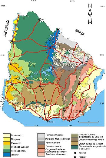
Precambrian
The Precambrian is the name which describes the large span of time in Earth's history before the current Phanerozoic Eon, and is a Supereon divided into several eons of the geologic time scale...
-aged shield
Shield (geology)
A shield is generally a large area of exposed Precambrian crystalline igneous and high-grade metamorphic rocks that form tectonically stable areas. In all cases, the age of these rocks is greater than 570 million years and sometimes dates back 2 to 3.5 billion years...
units with a region of volcanic rock
Volcanic rock
Volcanic rock is a rock formed from magma erupted from a volcano. In other words, it is an igneous rock of volcanic origin...
erupted during the Cretaceous
Cretaceous
The Cretaceous , derived from the Latin "creta" , usually abbreviated K for its German translation Kreide , is a geologic period and system from circa to million years ago. In the geologic timescale, the Cretaceous follows the Jurassic period and is followed by the Paleogene period of the...
and copious sedimentary
Sedimentary rock
Sedimentary rock are types of rock that are formed by the deposition of material at the Earth's surface and within bodies of water. Sedimentation is the collective name for processes that cause mineral and/or organic particles to settle and accumulate or minerals to precipitate from a solution....
facies
Facies
In geology, facies are a body of rock with specified characteristics. Ideally, a facies is a distinctive rock unit that forms under certain conditions of sedimentation, reflecting a particular process or environment....
the oldest of which date from the Devonian
Devonian
The Devonian is a geologic period and system of the Paleozoic Era spanning from the end of the Silurian Period, about 416.0 ± 2.8 Mya , to the beginning of the Carboniferous Period, about 359.2 ± 2.5 Mya...
. Big events that have shaped the geology of Uruguay
Uruguay
Uruguay ,officially the Oriental Republic of Uruguay,sometimes the Eastern Republic of Uruguay; ) is a country in the southeastern part of South America. It is home to some 3.5 million people, of whom 1.8 million live in the capital Montevideo and its metropolitan area...
include the Transamazonian orogeny (2000 million years ago (mya)), the breakup of Rodinia
Rodinia
In geology, Rodinia is the name of a supercontinent, a continent which contained most or all of Earth's landmass. According to plate tectonic reconstructions, Rodinia existed between 1.1 billion and 750 million years ago, in the Neoproterozoic era...
(700–500 mya) and the opening of the South Atlantic (~145 mya).
Shield region
The PrecambrianPrecambrian
The Precambrian is the name which describes the large span of time in Earth's history before the current Phanerozoic Eon, and is a Supereon divided into several eons of the geologic time scale...
shield
Shield (geology)
A shield is generally a large area of exposed Precambrian crystalline igneous and high-grade metamorphic rocks that form tectonically stable areas. In all cases, the age of these rocks is greater than 570 million years and sometimes dates back 2 to 3.5 billion years...
in Uruguay includes part of Río de la Plata craton
Rio de la Plata Craton
The Río de la Plata craton is one of the five cratons of the South American continent. The other four cratons are: Amazonian, São Francisco, Río Apa and Arequipa–Antofalla.It crops out in southern Uruguay and parts of Argentina...
, an extensive area of stable crystaline basement rock
Basement Rock
Basement or Basement Rock music was a sub-genre coined in 2006 in an article by music magazine TGR. This was first in relation to the existence of underground record label Criminal Records but more for the independent bands they represent. The roots of the sub-genre are noted to be as far back as...
underlying Uruguay and large areas of eastern Argentina
Argentina
Argentina , officially the Argentine Republic , is the second largest country in South America by land area, after Brazil. It is constituted as a federation of 23 provinces and an autonomous city, Buenos Aires...
and southern Brazil
Brazil
Brazil , officially the Federative Republic of Brazil , is the largest country in South America. It is the world's fifth largest country, both by geographical area and by population with over 192 million people...
. The shield in Uruguay goes under the name of Rio Grande do Sul—Uruguay Shield and includes parts of Southern Brazil. Though the Río de la Plata Craton underlies practically all of Uruguay, it only shows up in the south and east of the country since in other parts of the country, it is covered by younger volcanic rocks or sediments. The shield was formed during two orogenic
Orogeny
Orogeny refers to forces and events leading to a severe structural deformation of the Earth's crust due to the engagement of tectonic plates. Response to such engagement results in the formation of long tracts of highly deformed rock called orogens or orogenic belts...
events; one 2000 million years ago (mya) for the western part and another 700–500 mya for the eastern part. The later orogenic event is the result of the accretion
Accretion (geology)
Accretion is a process by which material is added to a tectonic plate or a landmass. This material may be sediment, volcanic arcs, seamounts or other igneous features.-Description:...
of blocks and terrane
Terrane
A terrane in geology is short-hand term for a tectonostratigraphic terrane, which is a fragment of crustal material formed on, or broken off from, one tectonic plate and accreted or "sutured" to crust lying on another plate...
s in the aftermath of the breakup of Rodinia
Rodinia
In geology, Rodinia is the name of a supercontinent, a continent which contained most or all of Earth's landmass. According to plate tectonic reconstructions, Rodinia existed between 1.1 billion and 750 million years ago, in the Neoproterozoic era...
when São Francisco
Sao Francisco craton
The São Francisco craton is located in the eastern part of South America. Outcrops in the Brazilian states of Minas Gerais and Bahia.It includes a number of different blocks of the Archean basement, separated by orogenic belts. The belts are characterized by sediment basins and passive continental...
and Río de la Plata cratons formed one plate in the west of the Adamastor ocean. The eastern part of the Uruguayan shield region is crossed by two major shear zone
Shear zone
A shear zone is a very important structural discontinuity surface in the Earth's crust and upper mantle. It forms as a response to inhomogeneous deformation partitioning strain into planar or curviplanar high-strain zones. Intervening blocks stay relatively unaffected by the deformation...
s both running roughly in north-south direction the dextral Sarandí del Yí-Piriápolis Shear Zone and the sinistral Sierra Ballena Shear Zone.
Sedimentary formations
After the assembly of the final shieldShield
A shield is a type of personal armor, meant to intercept attacks, either by stopping projectiles such as arrows or redirecting a hit from a sword, mace or battle axe to the side of the shield-bearer....
configuration the territory of Uruguay have been covered by several sedimentary formations ranging from Devonian
Devonian
The Devonian is a geologic period and system of the Paleozoic Era spanning from the end of the Silurian Period, about 416.0 ± 2.8 Mya , to the beginning of the Carboniferous Period, about 359.2 ± 2.5 Mya...
sandstone
Sandstone
Sandstone is a sedimentary rock composed mainly of sand-sized minerals or rock grains.Most sandstone is composed of quartz and/or feldspar because these are the most common minerals in the Earth's crust. Like sand, sandstone may be any colour, but the most common colours are tan, brown, yellow,...
s to Quaternary
Quaternary
The Quaternary Period is the most recent of the three periods of the Cenozoic Era in the geologic time scale of the ICS. It follows the Neogene Period, spanning 2.588 ± 0.005 million years ago to the present...
loess
Loess
Loess is an aeolian sediment formed by the accumulation of wind-blown silt, typically in the 20–50 micrometre size range, twenty percent or less clay and the balance equal parts sand and silt that are loosely cemented by calcium carbonate...
. All of the sedimentary formations covers only patches of the country since deposition
Deposition (geology)
Deposition is the geological process by which material is added to a landform or land mass. Fluids such as wind and water, as well as sediment flowing via gravity, transport previously eroded sediment, which, at the loss of enough kinetic energy in the fluid, is deposited, building up layers of...
have not been uniform and erosion
Erosion
Erosion is when materials are removed from the surface and changed into something else. It only works by hydraulic actions and transport of solids in the natural environment, and leads to the deposition of these materials elsewhere...
have cleaned surfaces, creeks and shores.
Sedimentary rock
Sedimentary rock
Sedimentary rock are types of rock that are formed by the deposition of material at the Earth's surface and within bodies of water. Sedimentation is the collective name for processes that cause mineral and/or organic particles to settle and accumulate or minerals to precipitate from a solution....
s of Lower Devonian
Devonian
The Devonian is a geologic period and system of the Paleozoic Era spanning from the end of the Silurian Period, about 416.0 ± 2.8 Mya , to the beginning of the Carboniferous Period, about 359.2 ± 2.5 Mya...
age are found in the central part of Uruguay being exposed as a narrow east-west to northeast oriented band. The upper and better known part of this sequence
Sequence (geology)
A sequence in geology refers to a sequence of geological events, processes, or rocks, arranged in chronological order.A rock stratigraphical sequence is a geographical, or lithostratigraphic, discrete unit greater than a group or supergroup rank, and traceable over large areas of a continent...
is made up of sandstone
Sandstone
Sandstone is a sedimentary rock composed mainly of sand-sized minerals or rock grains.Most sandstone is composed of quartz and/or feldspar because these are the most common minerals in the Earth's crust. Like sand, sandstone may be any colour, but the most common colours are tan, brown, yellow,...
. The lower sandstones of this sequence have characteristics similar to the Furna sandstones of São Paulo in Brazil
Brazil
Brazil , officially the Federative Republic of Brazil , is the largest country in South America. It is the world's fifth largest country, both by geographical area and by population with over 192 million people...
. During the Late Paleozoic
Paleozoic
The Paleozoic era is the earliest of three geologic eras of the Phanerozoic eon, spanning from roughly...
the territory of Uruguay was affected by the Karoo Glaciation
Karoo Ice Age
The Karoo Ice Age from 360–260 Ma was the second major ice age of the Phanerozoic Eon. It is named after the glacial tills found in the Karoo region of South Africa where evidence for this ice age was first clearly identified....
and was subsequently covered by ice lobes of the great ice sheet
Ice sheet
An ice sheet is a mass of glacier ice that covers surrounding terrain and is greater than 50,000 km² , thus also known as continental glacier...
that covered large parts of Gondwana
Gondwana
In paleogeography, Gondwana , originally Gondwanaland, was the southernmost of two supercontinents that later became parts of the Pangaea supercontinent. It existed from approximately 510 to 180 million years ago . Gondwana is believed to have sutured between ca. 570 and 510 Mya,...
. Glacial striae on shale
Shale
Shale is a fine-grained, clastic sedimentary rock composed of mud that is a mix of flakes of clay minerals and tiny fragments of other minerals, especially quartz and calcite. The ratio of clay to other minerals is variable. Shale is characterized by breaks along thin laminae or parallel layering...
s and varve
Varve
A varve is an annual layer of sediment or sedimentary rock.The word 'varve' is derived from the Swedish word varv whose meanings and connotations include 'revolution', 'in layers', and 'circle'. The term first appeared as Hvarfig lera on the first map produced by the Geological Survey of Sweden in...
-like sediments found in Uruguay have been associated with this glaciation.
During the early rift
Rift
In geology, a rift or chasm is a place where the Earth's crust and lithosphere are being pulled apart and is an example of extensional tectonics....
ing stages of the South Atlantic the area of southern Paraná Basin
Parana Basin
The Paraná Basin is a large sedimentary basin situated in the central-eastern part of South America. About 75% of its areal distribution occurs in Brazil, from Mato Grosso to Rio Grande do Sul states. The remainder area is distributed in eastern Paraguay, northeastern Argentina and northern...
suffered a gentle uplifting that deviated sediments into the Tacuarembó region of Uruguay. These changes led to the formation of the Itacuanbú and Tacuarembó formations during the Mid Jurassic
Jurassic
The Jurassic is a geologic period and system that extends from about Mya to Mya, that is, from the end of the Triassic to the beginning of the Cretaceous. The Jurassic constitutes the middle period of the Mesozoic era, also known as the age of reptiles. The start of the period is marked by...
to Early Creataceous. Parts of the Tacuarembó formation came to be preserved thanks to a unit of the Paraná traps, the Arapey basalt
Basalt
Basalt is a common extrusive volcanic rock. It is usually grey to black and fine-grained due to rapid cooling of lava at the surface of a planet. It may be porphyritic containing larger crystals in a fine matrix, or vesicular, or frothy scoria. Unweathered basalt is black or grey...
s, that erupted 132 mya and covered the sediments.
Igneous province
In the north of Uruguay, volcanic materials from the Paraná continental flood basalt provinceParaná and Etendeka traps
The Paraná-Etendeka traps comprise a large igneous province which includes both the main Paraná traps as well as the smaller severed portions of the flood basalts at the Etendeka traps in Namibia and Angola. The original basalt flows occurred 128 to 138 million years ago...
form a major lithological
Lithology
The lithology of a rock unit is a description of its physical characteristics visible at outcrop, in hand or core samples or with low magnification microscopy, such as colour, texture, grain size, or composition. It may be either a detailed description of these characteristics or be a summary of...
unit extending beyond Uruguay's borders into Argentina and Brazil, with parts of it now lying in Namibia
Namibia
Namibia, officially the Republic of Namibia , is a country in southern Africa whose western border is the Atlantic Ocean. It shares land borders with Angola and Zambia to the north, Botswana to the east and South Africa to the south and east. It gained independence from South Africa on 21 March...
on the other side of the Atlantic due to plate tectonics
Plate tectonics
Plate tectonics is a scientific theory that describes the large scale motions of Earth's lithosphere...
. This volcanic material erupted in the Cretaceous
Cretaceous
The Cretaceous , derived from the Latin "creta" , usually abbreviated K for its German translation Kreide , is a geologic period and system from circa to million years ago. In the geologic timescale, the Cretaceous follows the Jurassic period and is followed by the Paleogene period of the...
period during the opening of the South Atlantic and has been linked to the Tristan da Cunha
Tristan hotspot
The Tristan hotspot is a volcanic hotspot which is responsible for the volcanic activity which forms the volcanoes in the southern Atlantic Ocean. It is thought to have formed the island of Tristan da Cunha and the Walvis Ridge on the African Plate....
plume
Mantle plume
A mantle plume is a hypothetical thermal diapir of abnormally hot rock that nucleates at the core-mantle boundary and rises through the Earth's mantle. Such plumes were invoked in 1971 to explain volcanic regions that were not thought to be explicable by the then-new theory of plate tectonics. Some...
. The bulk of this volcanic material is basalt
Basalt
Basalt is a common extrusive volcanic rock. It is usually grey to black and fine-grained due to rapid cooling of lava at the surface of a planet. It may be porphyritic containing larger crystals in a fine matrix, or vesicular, or frothy scoria. Unweathered basalt is black or grey...
but there are rhyolite
Rhyolite
This page is about a volcanic rock. For the ghost town see Rhyolite, Nevada, and for the satellite system, see Rhyolite/Aquacade.Rhyolite is an igneous, volcanic rock, of felsic composition . It may have any texture from glassy to aphanitic to porphyritic...
s as well. Associated with this volcanism are also syenite
Syenite
Syenite is a coarse-grained intrusive igneous rock of the same general composition as granite but with the quartz either absent or present in relatively small amounts Syenite is a coarse-grained intrusive igneous rock of the same general composition as granite but with the quartz either absent or...
and other granitoid
Granitoid
A granitoid or granitic rock is a variety of coarse grained plutonic rock similar to granite which mineralogically are composed predominately of feldspar and quartz. Examples of granitoid rocks include granite, quartz monzonite, quartz diorite, syenite, granodiorite and trondhjemite. Many are...
intrusion
Intrusion
An intrusion is liquid rock that forms under Earth's surface. Magma from under the surface is slowly pushed up from deep within the earth into any cracks or spaces it can find, sometimes pushing existing country rock out of the way, a process that can take millions of years. As the rock slowly...
s exposed as outcrop
Outcrop
An outcrop is a visible exposure of bedrock or ancient superficial deposits on the surface of the Earth. -Features:Outcrops do not cover the majority of the Earth's land surface because in most places the bedrock or superficial deposits are covered by a mantle of soil and vegetation and cannot be...
s in small areas of Southeastern Uruguay. Although volcanic rocks of the Paraná volcanism underlies more than half of Uruguay, they have in many areas been covered by younger sediments so that the lavas only crop out as a geological province in the Uruguayan northwest.
External links
- National Mining and Geology Office
- Soil, topography, climate and agro-ecological zones of Uruguay by Food and Agriculture OrganizationFood and Agriculture OrganizationThe Food and Agriculture Organization of the United Nations is a specialised agency of the United Nations that leads international efforts to defeat hunger. Serving both developed and developing countries, FAO acts as a neutral forum where all nations meet as equals to negotiate agreements and...
- Geological evolution of Uruguay by Agronomy Faculty, Universidad de la RepúblicaUniversity of the Republic, UruguayThe University of the Republic is Uruguay's public university. It is the most important and country's largest university, with a student body of more than 80,000 students. It was founded on July 18, 1849 in Montevideo, where most of its buildings and facilities are still located. Its current...
, Uruguay