
Geography of New South Wales
Encyclopedia
New South Wales is Australia's
most populous state, located in the east coast of the continent. It is in the southern hemisphere between latitudes 28
and 38 degrees south
of the equator and longitudes 143
and 154 degrees east
of the Universal Prime Meridian
(formerly known as the Greenwich meridian
). The state is in the warm temperate climatic zone.
The area of New South Wales
is 809444 km² (312,528 sq mi). The coastline is 2137 km (1,328 mi) in length.
Cape Byron
, in the north-east of the state, is Australia's most easterly mainland point.
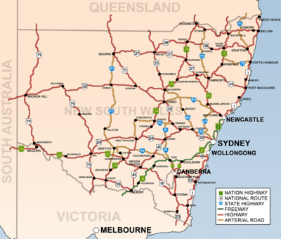
The state is bordered on the north by Queensland
, on the west by South Australia
, and on the south by Victoria
. Its coast faces the Tasman Sea
. New South Wales contains two Federal enclaves: the Australian Capital Territory
(ACT), and the Jervis Bay Territory
.
 New South Wales can be divided physically into four sections:
The steep escarpment of the Blue Mountains to the west of Sydney prevented European exploration beyond the coastal strip for several years until explorer Gregory Blaxland
found a way through in 1813, 25 years after the first settlement in Sydney.
, Gosford
, Sydney
, and Wollongong
which all lie along the coast. Other cities and towns include Albury
, Broken Hill
, Dubbo, Tamworth
, Armidale
, Lismore
, Nowra
, Griffith
, Leeton
, Wagga Wagga, Goulburn
and Coffs Harbour
.
Australia
Australia , officially the Commonwealth of Australia, is a country in the Southern Hemisphere comprising the mainland of the Australian continent, the island of Tasmania, and numerous smaller islands in the Indian and Pacific Oceans. It is the world's sixth-largest country by total area...
most populous state, located in the east coast of the continent. It is in the southern hemisphere between latitudes 28
28th parallel south
The 28th parallel south is a circle of latitude that is 28 degrees south of the Earth's equatorial plane. It crosses the Atlantic Ocean, Africa, the Indian Ocean, Australasia, the Pacific Ocean and South America....
and 38 degrees south
38th parallel south
The 38th parallel south is a circle of latitude that is 38 degrees south of the Earth's equatorial plane. It crosses the Atlantic Ocean, the Indian Ocean, Australia, New Zealand, the Pacific Ocean, and the southern end of South America, including the Andes Mountains and Patagonia.At this latitude...
of the equator and longitudes 143
143rd meridian east
The 143rd meridian east of Greenwich is a line of longitude that extends from the North Pole across the Arctic Ocean, Asia, the Pacific Ocean, Australasia, the Indian Ocean, the Southern Ocean, and Antarctica to the South Pole....
and 154 degrees east
154th meridian east
The meridian 154° east of Greenwich is a line of longitude that extends from the North Pole across the Arctic Ocean, Asia, the Pacific Ocean, Australasia, the Southern Ocean, and Antarctica to the South Pole....
of the Universal Prime Meridian
Prime Meridian
The Prime Meridian is the meridian at which the longitude is defined to be 0°.The Prime Meridian and its opposite the 180th meridian , which the International Date Line generally follows, form a great circle that divides the Earth into the Eastern and Western Hemispheres.An international...
(formerly known as the Greenwich meridian
Royal Observatory, Greenwich
The Royal Observatory, Greenwich , in London, England played a major role in the history of astronomy and navigation, and is best known as the location of the prime meridian...
). The state is in the warm temperate climatic zone.
The area of New South Wales
New South Wales
New South Wales is a state of :Australia, located in the east of the country. It is bordered by Queensland, Victoria and South Australia to the north, south and west respectively. To the east, the state is bordered by the Tasman Sea, which forms part of the Pacific Ocean. New South Wales...
is 809444 km² (312,528 sq mi). The coastline is 2137 km (1,328 mi) in length.
Cape Byron
Cape Byron
Cape Byron is the easternmost point of the mainland of Australia. It is located about northeast of the town of Byron Bay and projects into the Pacific Ocean...
, in the north-east of the state, is Australia's most easterly mainland point.
The state is bordered on the north by Queensland
Queensland
Queensland is a state of Australia, occupying the north-eastern section of the mainland continent. It is bordered by the Northern Territory, South Australia and New South Wales to the west, south-west and south respectively. To the east, Queensland is bordered by the Coral Sea and Pacific Ocean...
, on the west by South Australia
South Australia
South Australia is a state of Australia in the southern central part of the country. It covers some of the most arid parts of the continent; with a total land area of , it is the fourth largest of Australia's six states and two territories.South Australia shares borders with all of the mainland...
, and on the south by Victoria
Victoria (Australia)
Victoria is the second most populous state in Australia. Geographically the smallest mainland state, Victoria is bordered by New South Wales, South Australia, and Tasmania on Boundary Islet to the north, west and south respectively....
. Its coast faces the Tasman Sea
Tasman Sea
The Tasman Sea is the large body of water between Australia and New Zealand, approximately across. It extends 2,800 km from north to south. It is a south-western segment of the South Pacific Ocean. The sea was named after the Dutch explorer Abel Janszoon Tasman, the first recorded European...
. New South Wales contains two Federal enclaves: the Australian Capital Territory
Australian Capital Territory
The Australian Capital Territory, often abbreviated ACT, is the capital territory of the Commonwealth of Australia and is the smallest self-governing internal territory...
(ACT), and the Jervis Bay Territory
Jervis Bay Territory
The Jervis Bay Territory is a territory of the Commonwealth of Australia. It was surrendered by the state of New South Wales to the Commonwealth Government in 1915 so that the Federal capital at Canberra would have "access to the sea"....
.
- A thin coastal strip, with climates warming from cool temperate on the far south coast to subtropical near the Queensland border, including the regions south of Sydney such as the IllawarraIllawarraIllawarra is a region in the Australian state of New South Wales. It is a coastal region situated immediately south of Sydney and north of the Shoalhaven or South Coast region. It encompasses the cities of Wollongong, Shellharbour, Shoalhaven and the town of Kiama. The central region contains Lake...
and ShoalhavenShoalhavenThe City of Shoalhaven is a Local Government Area in south-eastern New South Wales , Australia, two hours south of Sydney. It is more or less conterminous with an area referred to as The Shoalhaven. It is on the Pacific Ocean and the Princes Highway and is the terminus of the South Coast line...
near Nowra. North of Sydney are the Central CoastCentral Coast, New South WalesThe Central Coast is an urban region in the Australian state of New South Wales, located on the coast north of Sydney and south of Lake Macquarie....
and NewcastleNewcastle, New South WalesThe Newcastle metropolitan area is the second most populated area in the Australian state of New South Wales and includes most of the Newcastle and Lake Macquarie Local Government Areas...
, Hunter Region, Mid North Coast and Northern Rivers regions. - The mountainous areas of the Great Dividing RangeGreat Dividing RangeThe Great Dividing Range, or the Eastern Highlands, is Australia's most substantial mountain range and the third longest in the world. The range stretches more than 3,500 km from Dauan Island off the northeastern tip of Queensland, running the entire length of the eastern coastline through...
and the high country surrounding them. Whilst not particularly steep, many peaks rise above 1,000 m, with the highest Mount KosciuszkoMount KosciuszkoMount Kosciuszko is a mountain located in the Snowy Mountains in Kosciuszko National Park. With a height of 2,228 metres above sea level, it is the highest mountain in Australia...
at 2,229 m (7,308 ft). This includes the Southern Highlands, Central TablelandsCentral TablelandsThe Central Tablelands in New South Wales is an area that is between the Sydney Metropolitan Area and the Central West Slopes and Plains. This area has a part of the Great Dividing Range running through it, including the Blue Mountains...
and the Northern Tablelands. - The agricultural plains that fill a significant portion of the state's area, with a much sparser population than the coast, including The RiverinaRiverinaThe Riverina is an agricultural region of south-western New South Wales , Australia. The Riverina is distinguished from other Australian regions by the combination of flat plains, warm to hot climate and an ample supply of water for irrigation. This combination has allowed the Riverina to develop...
area around Wagga Wagga. - The Western Plains covering almost two-thirds of the state. In some years production is limited by water availability.
The steep escarpment of the Blue Mountains to the west of Sydney prevented European exploration beyond the coastal strip for several years until explorer Gregory Blaxland
Gregory Blaxland
Gregory Blaxland was a pioneer farmer and explorer in Australia.- Early life :Gregory Blaxland was born 17 June 1778 at Fordwich, Kent, England, the fourth son of John Blaxland, mayor from 1767 to 1774, whose family had owned estates nearby for generations, and Mary, daughter of Captain Parker,...
found a way through in 1813, 25 years after the first settlement in Sydney.
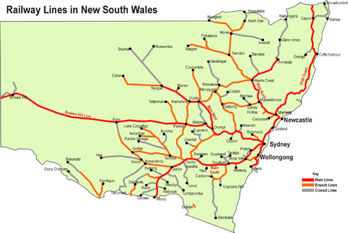
Cities and towns
Its four main cities from north to south are NewcastleNewcastle, New South Wales
The Newcastle metropolitan area is the second most populated area in the Australian state of New South Wales and includes most of the Newcastle and Lake Macquarie Local Government Areas...
, Gosford
Gosford, New South Wales
Gosford is a city located on the Central Coast of New South Wales, Australia, approximately 76 km north of the Sydney central business district...
, Sydney
Sydney
Sydney is the most populous city in Australia and the state capital of New South Wales. Sydney is located on Australia's south-east coast of the Tasman Sea. As of June 2010, the greater metropolitan area had an approximate population of 4.6 million people...
, and Wollongong
Wollongong, New South Wales
Wollongong is a seaside city located in the Illawarra region of New South Wales, Australia. It lies on the narrow coastal strip between the Illawarra Escarpment and the Pacific Ocean, 82 kilometres south of Sydney...
which all lie along the coast. Other cities and towns include Albury
Albury, New South Wales
Albury is a major regional city in New South Wales, Australia, located on the Hume Highway on the northern side of the Murray River. It is located wholly within the boundaries of the City of Albury Local Government Area...
, Broken Hill
Broken Hill, New South Wales
-Geology:Broken Hill's massive orebody, which formed about 1,800 million years ago, has proved to be among the world's largest silver-lead-zinc mineral deposits. The orebody is shaped like a boomerang plunging into the earth at its ends and outcropping in the centre. The protruding tip of the...
, Dubbo, Tamworth
Tamworth, New South Wales
Tamworth is a city in the New England region of New South Wales, Australia. Straddling the Peel River, Tamworth, which contains an estimated population of 47,595 people, is the major regional centre for southern New England and in the local government area of Tamworth Regional Council. The city...
, Armidale
Armidale, New South Wales
Armidale is a city in the Northern Tablelands, New South Wales, Australia. Armidale Dumaresq Shire had a population of 19,485 people according to the 2006 census. It is the administrative centre for the Northern Tablelands region...
, Lismore
Lismore, New South Wales
Lismore is a subtropical town in northeastern New South Wales, Australia. Lismore is the main population centre in the City of Lismore local government area. Lismore is a regional centre in the Northern Rivers region of the State.-History:...
, Nowra
Nowra, New South Wales
Nowra is a city in the South Coast region of New South Wales, Australia. Located SSW and approximately by road south of the state capital of Sydney, it has an estimated population together with its twin-town of Bomaderry of 34,479. It is also the seat and commercial centre of the City of Shoalhaven...
, Griffith
Griffith, New South Wales
Griffith is a city in south-western New South Wales, Australia. It is also the seat of the City of Griffith local government area. Like the Australian capital, Canberra and the nearby town of Leeton, Griffith was designed by Walter Burley Griffin. Griffith was named after Sir Arthur Griffith the...
, Leeton
Leeton, New South Wales
Leeton is a town in the Riverina region of New South Wales, Australia. Leeton is situated approximately 550 km west of Sydney and 450 km north of Melbourne in the productive Murrumbidgee Irrigation Area. Leeton is administered by Leeton Shire Council...
, Wagga Wagga, Goulburn
Goulburn, New South Wales
Goulburn is a provincial city in the Southern Tablelands of New South Wales, Australia in Goulburn Mulwaree Council Local Government Area. It is located south-west of Sydney on the Hume Highway and above sea-level. On Census night 2006, Goulburn had a population of 20,127 people...
and Coffs Harbour
Coffs Harbour, New South Wales
-History:By the early 1900s, the Coffs Harbour area had become an important timber production centre. Before the opening of the North Coast Railway Line, the only way to transport large items of heavy but low value, such as timber, was by coastal shipping. This meant sawmillers on the North Coast...
.