
Shoalhaven
Encyclopedia
- "Shoalhaven" redirects here. For the river of the same name, see Shoalhaven RiverShoalhaven RiverThe Shoalhaven River is a river rising from the Southern Tablelands and flowing into the ocean near Nowra on the South Coast of New South Wales, Australia.- History :...
.
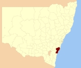
The City of Shoalhaven is a Local Government Area (population 88,405) in south-eastern New South Wales
New South Wales
New South Wales is a state of :Australia, located in the east of the country. It is bordered by Queensland, Victoria and South Australia to the north, south and west respectively. To the east, the state is bordered by the Tasman Sea, which forms part of the Pacific Ocean. New South Wales...
(NSW), Australia
Australia
Australia , officially the Commonwealth of Australia, is a country in the Southern Hemisphere comprising the mainland of the Australian continent, the island of Tasmania, and numerous smaller islands in the Indian and Pacific Oceans. It is the world's sixth-largest country by total area...
, two hours south of Sydney
Sydney
Sydney is the most populous city in Australia and the state capital of New South Wales. Sydney is located on Australia's south-east coast of the Tasman Sea. As of June 2010, the greater metropolitan area had an approximate population of 4.6 million people...
. It is more or less conterminous with an area referred to as The Shoalhaven. It is on the Pacific Ocean
Pacific Ocean
The Pacific Ocean is the largest of the Earth's oceanic divisions. It extends from the Arctic in the north to the Southern Ocean in the south, bounded by Asia and Australia in the west, and the Americas in the east.At 165.2 million square kilometres in area, this largest division of the World...
and the Princes Highway
Princes Highway
The Princes Highway extends from Sydney to Port Augusta via the coast through the states of New South Wales, Victoria and South Australia, a distance of 1941 km or 1898 km via the former alignments of the highway ....
and is the terminus of the South Coast line
South Coast railway line, New South Wales
The South Coast Line is in the intercity region of Sydney's CityRail services. It serves the coastal region to the south of the Sydney metropolitan area including the Illawarra region, most notably the regional city of Wollongong, and extended services reach as far as Nowra in Shoalhaven.- Line...
. Services are administered by the Shoalhaven City Council.
History
The Shoalhaven region in New South Wales is the southern part of the traditional homelands of the Tharawal peopleTharawal people
The Tharawal people were the Aboriginal inhabitants of southern Sydney and the Illawarra region in 1788, when the first European colonists arrived. The Tharawal people lived in the areas from south side of Botany Bay, around Port Hacking to north of the Shoalhaven River and inland to Campbelltown...
.
George Bass
George Bass
George Bass was a British naval surgeon and explorer of Australia.-Early years:He was born on 30 January 1771 at Aswarby, a hamlet near Sleaford, Lincolnshire, the son of a tenant farmer, George Bass, and a local beauty named Sarah Nee Newman. His father died in 1777 when Bass was 6...
explored the area in 1797, following Seven Mile Beach
Seven Mile Beach, New South Wales
thumb|300px|Seven Mile Beach at sunsetSeven Mile Beach is a long beach with strong historical reference just south of Gerringong in the Shoalhaven area of New South Wales, Australia....
. He crossed the shoals at the entrance to the river, calling it 'Shoals Haven' due to the shallowness of the river mouth. This river is now known as the Crookhaven, but the name was adopted for the Shoalhaven area and the Shoalhaven River
Shoalhaven River
The Shoalhaven River is a river rising from the Southern Tablelands and flowing into the ocean near Nowra on the South Coast of New South Wales, Australia.- History :...
.
Towns
The city actually consists of a number of distinct towns that share the one government. These towns include:- NowraNowra, New South WalesNowra is a city in the South Coast region of New South Wales, Australia. Located SSW and approximately by road south of the state capital of Sydney, it has an estimated population together with its twin-town of Bomaderry of 34,479. It is also the seat and commercial centre of the City of Shoalhaven...
and BomaderryBomaderry, New South WalesBomaderry is a town in the Shoalhaven council district area of New South Wales, Australia. In 2006, it had a population of 6,601 people. It is on the north shore of the Shoalhaven River, across the river from Nowra, the major town of the Shoalhaven,of which Bomaderry is locally regarded as being...
; - North of Nowra: BerryBerry, New South WalesBerry is a small Australian town in the Shoalhaven region of the NSW South Coast in the state of New South Wales, located south of the state capital, Sydney. The indigenous people of the area were the Wodi Wodi people. In the 1810s, George William Evans, Government Surveyor, reported on the Berry...
, Kangaroo ValleyKangaroo Valley, New South WalesKangaroo Valley is a valley along the Kangaroo River in the Illawarra region of New South Wales, Australia, located west of the seaside in the City of Shoalhaven...
, Shoalhaven Heads and Jaspers Brush; - Around Jervis BayJervis BayJervis Bay is a large bay bounded by the state of New South Wales, the Jervis Bay Territory, and a detached enclave of the Australian Capital Territory. HMAS Creswell is located between Jervis Bay Village and Greenpatch in the Jervis Bay Territory.-History:...
: HuskissonHuskisson, New South WalesHuskisson is a town in New South Wales, Australia in the City of Shoalhaven, on the shores of Jervis Bay. It is 24 km south-east of Nowra.Situated alongside Currambene Creek which serves also as an anchorage and fishing port...
, VincentiaVincentia, New South WalesVincentia is a town in New South Wales, Australia in the City of Shoalhaven, on the shores of Jervis Bay. It is roughly 25 km south-east of Nowra, and approximately 200 km south of Sydney. In 2006, the population of the State Suburb of Vincentia was 2,875....
, Greenwell PointGreenwell Point, New South WalesGreenwell Point is in the Shoalhaven region of New South Wales, Australia. It is about 13 km east of Nowra on the South Coast. At the 2006 Census of Population and Housing, the town had a population of 1,276....
, Culburra BeachCulburra Beach, New South WalesCulburra Beach, commonly referred to as Culburra, is in the Shoalhaven region of New South Wales, Australia. It is 18 km east-southeast of Nowra on the South Coast...
, CurrarongCurrarong, New South WalesCurrarong is a small coastal fishing and tourist village in the Shoalhaven area of New South Wales, Australia. At the 2006 census, Currarong had a population of 513. The village is a haven for fishermen, with several underwater rises where fish are abundant...
, Callala Beach, Callala BayCallala Bay, New South WalesCallala Bay is a small town on the South Coast of New South Wales, Australia in the City of Shoalhaven. It is situated on the northern shore of Jervis Bay about 20 minutes drive from Nowra and 10 minutes from Culburra Beach...
, Orient PointOrient Point, New South WalesOrient Point is a small village in the Shoalhaven area of New South Wales, Australia. It is located on the southern side of the mouth of the Shoalhaven River and adjoins the village of Culburra to the south. The Jerringa Aboriginal Mission is located near the village...
, Hyams BeachHyams Beach, New South WalesHyams Beach is a small seaside village in the Shoalhaven, New South Wales, Australia, on the shores of Jervis Bay. The village, roughly 3 hours drive south of Sydney, is bordered by 3 beaches, Chinaman's Beach to the north, Hyams Beach and Seaman's Beach to the south...
, Sanctuary PointSanctuary Point, New South Wales2Sanctuary Point is a town in New South Wales, Australia in the City of Shoalhaven, on the shores of St Georges Basin. It is roughly 25 km south of Nowra, and approximately 200 km south of Sydney...
, St Georges BasinSt Georges Basin, New South WalesSt Georges Basin is a town in New South Wales, Australia in the City of Shoalhaven, on the shores of St Georges Basin. It is roughly 25 km south of Nowra, and approximately 200 km south of Sydney. In 2006, the population of St Georges Basin, together with Sanctuary Point and Basin View, was...
, Basin ViewBasin View, New South WalesBasin View is a town in New South Wales, Australia in the City of Shoalhaven, on the shores of St Georges Basin. It is roughly 25 km south of Nowra, and approximately 200 km south of Sydney. In 2006, the population of Basin View was .- References :...
, Falls Creek, Tomerong, WandandianWandandian, New South WalesWandandian is a small village on the South Coast of New South Wales, Australia. Located at the centre of the City of Shoalhaven, Wandandian was first established as a Postal District in 1860, and has a rich history. The village takes its name from the Wandandian people, the traditional owners of...
, Bream Beach, Wrights BeachWrights Beach, New South WalesWrights Beach is a town in the Shoalhaven local government area, in New South Wales, Australia. It is on the shores of St Georges Basin, near the Jervis Bay Territory.-Geography:...
; - Further south: Sussex InletSussex Inlet, New South WalesSussex Inlet is a town in Shoalhaven, New South Wales, Australia. It lies on the west bank of the waterway called Sussex Inlet, which divides New South Wales from the Jervis Bay Territory.Jervis Bay Airport is located about 10 km east of Sussex Inlet....
, Berrara, Cudmirrah, Bendalong, Cunjurong, ManyanaManyana, New South WalesManyana is a small town on the South Coast of New South Wales, Australia in the Shoalhaven. At the 2006 census, Manyana had a population of 363....
and Lake ConjolaLake Conjola, New South WalesLake Conjola is a small town situated on the South Coast of New South Wales, Australia. It is located in the region of Ulladulla, in the Shoalhaven. At the 2006 census, Lake Conjola had a population of 371 people. Lake Conjola is a popular tourist destination for boaters and fisherman. Fish in...
; - The towns of the UlladullaUlladulla, New South WalesUlladulla is a coastal town in New South Wales, Australia in the City of Shoalhaven local government area. It is on the Princes Highway, about half way between the larger towns of Batemans Bay to the south and Nowra to the north and approximately 179 km south of Sydney...
area: (Ulladulla, MiltonMilton, New South WalesMilton is a town in the City of Shoalhaven on the South Coast of New South Wales, Australia, not far from Ulladulla. It was founded in the middle of the 19th century...
and MollymookMollymook, New South WalesMollymook is located on the South Coast of New South Wales, Australia and is part of the Milton–Ulladulla area, which is approximately 3 hours drive south of Sydney. At the 2006 census, Mollymook had a population of 1,054 people. It forms part of a seven kilometre stretch of unbroken urban...
); and - In the far south: Burrill LakeBurrill Lake, New South WalesBurrill Lake is a small village in the Shoalhaven area of New South Wales, Australia. A sea side suburb the housing area based around the lake area. Winding streets with park area and many holiday homes, this is a picturesque area to holiday and live....
, Tabourie LakeTabourie Lake, New South WalesTabourie Lake is a small village in the Shoalhaven area of New South Wales, Australia. The village gets its name from the lagoon formed at the entry of Tabourie Creek into the ocean. Crampton Island lies immediately off shore with access available by foot at low tide. A caravan and camping park is...
, TermeilTermeil, New South WalesTermeil is a small village in the Shoalhaven area of New South Wales, Australia....
, Bawley Point and KioloaKioloa, New South WalesKioloa is a small hamlet located on the South Coast of New South Wales, Australia. It is pronounced by locals as 'Ky-ola'. At the 2006 census, Kioloa had a population of 196 people....
.
Currarong
Currarong is a small coastal fishing–tourist village in the City of Shoalhaven with a population of less than 250.The village is a haven for fishermen, with several underwater rises where fish are abundant. Currarong has a small general store, a newsagents and a cafe.
To the north of Shoalhaven is located the coastal Illawarra
Illawarra
Illawarra is a region in the Australian state of New South Wales. It is a coastal region situated immediately south of Sydney and north of the Shoalhaven or South Coast region. It encompasses the cities of Wollongong, Shellharbour, Shoalhaven and the town of Kiama. The central region contains Lake...
region and in the south on the South Coast
South Coast, New South Wales
The South Coast refers to the narrow coastal belt from Sydney in the north to the border with Victoria in the south in the south-eastern part of the State of New South Wales, Australia. It is bordered to the west by the coastal escarpment of the Southern Tablelands, which is largely covered by a...
(which are geographic, rather than administrative regions).
Culburra Beach
Culburra Beach, with a population of 3,500 is the regional centre for the coastal villages east of Nowra. Originally designed by Walter Burley Griffin, the architect who designed Canberra, its shops and businesses provide a range of services and places to eat for residents and visitors to the region.The town also boasts the two closest surf beaches to Nowra and is home to the Culburra Beach and Nowra Surf Club whose clubhouse is located at the northern end of Warrain Beach. The beaches are patrolled during the summer holiday period, and being located on either side of Penguin Head face in different directions, providing a variety of surf conditions for board riders, swimmers, body surfers and families with young children. A wide variety of fish species are caught on these beaches and from the rocky headlands adjacent to them.
Tourism
The Shoalhaven can be reached from SydneySydney
Sydney is the most populous city in Australia and the state capital of New South Wales. Sydney is located on Australia's south-east coast of the Tasman Sea. As of June 2010, the greater metropolitan area had an approximate population of 4.6 million people...
by car via the Princes Highway
Princes Highway
The Princes Highway extends from Sydney to Port Augusta via the coast through the states of New South Wales, Victoria and South Australia, a distance of 1941 km or 1898 km via the former alignments of the highway ....
and by rail via CityRail
CityRail
CityRail is an operating brand of RailCorp, a corporation owned by the state government of New South Wales, Australia. It is responsible for providing commuter rail services, and some coach services, in and around Sydney, Newcastle and Wollongong, the three largest cities of New South Wales. It is...
's South Coast Line which terminates just north of Nowra in Bomaderry. The most well-known part of the Shoalhaven is the Jervis Bay
Jervis Bay Territory
The Jervis Bay Territory is a territory of the Commonwealth of Australia. It was surrendered by the state of New South Wales to the Commonwealth Government in 1915 so that the Federal capital at Canberra would have "access to the sea"....
area. The area is approximately 160 kilometres long along the coastline, including 109 beaches, which allegedly possesses the whitest sand in the world, as well as pristine natural Australian bushland. The Shoalhaven area is home to numerous species of native Australian flora and fauna.
Culture
The area is well-known for its strong commitment to the arts and music, featuring the See ChangeSee Change Festival
The See Change Festival is a biennial arts festival run in the Jervis Bay area, within Shoalhaven city, over the June long-weekend. See Change is the sister festival of See Celebrations.-External links:*...
and See Celebrations festivals in the Jervis Bay
Jervis Bay Territory
The Jervis Bay Territory is a territory of the Commonwealth of Australia. It was surrendered by the state of New South Wales to the Commonwealth Government in 1915 so that the Federal capital at Canberra would have "access to the sea"....
and St Georges Basin
St Georges Basin, New South Wales
St Georges Basin is a town in New South Wales, Australia in the City of Shoalhaven, on the shores of St Georges Basin. It is roughly 25 km south of Nowra, and approximately 200 km south of Sydney. In 2006, the population of St Georges Basin, together with Sanctuary Point and Basin View, was...
areas, as well as the EscapeArtfest festival and Blessing of the Fleet
Blessing of the Fleet
The Blessing of the Fleet is a tradition that began centuries ago in Mediterranean fishing communities. The practice is predominantly Catholic and a blessing from the local priest was meant to ensure a safe and bountiful season...
in the Ulladulla
Ulladulla, New South Wales
Ulladulla is a coastal town in New South Wales, Australia in the City of Shoalhaven local government area. It is on the Princes Highway, about half way between the larger towns of Batemans Bay to the south and Nowra to the north and approximately 179 km south of Sydney...
area.
Council
Shoalhaven City Council has a directly elected Mayor and 12 elected councillors representing three wards:| Mayor |
| Paul Green |
| Ward 1 | Ward 2 | Ward 3 |
| Andrew Guile | David Bennett | Amanda Findley |
| Gary Kearney | Bohdan Brumerskyj | Robert Miller |
| Nigel Soames | John Fergusson | Bob Proudfoot |
| Gareth Ward Gareth Ward Gareth James Ward MP , an Australian politician, is a Member of the New South Wales Legislative Assembly representing Kiama for the Liberal Party of Australia since 2011. He is also a councillor on Shoalhaven City Council since 2004.... (Deputy Mayor) |
Greg Watson | Josi Young |
The Deputy Mayor is elected from among the 12 elected councillors