

Geography of Mozambique
Encyclopedia
Southern Africa
Africa
Africa is the world's second largest and second most populous continent, after Asia. At about 30.2 million km² including adjacent islands, it covers 6% of the Earth's total surface area and 20.4% of the total land area...
, bordering the Mozambique Channel, between South Africa
South Africa
The Republic of South Africa is a country in southern Africa. Located at the southern tip of Africa, it is divided into nine provinces, with of coastline on the Atlantic and Indian oceans...
and Tanzania
Tanzania
The United Republic of Tanzania is a country in East Africa bordered by Kenya and Uganda to the north, Rwanda, Burundi, and the Democratic Republic of the Congo to the west, and Zambia, Malawi, and Mozambique to the south. The country's eastern borders lie on the Indian Ocean.Tanzania is a state...
Geographic coordinates:
18°15′S 35°00′E
Map references:
Africa
Area:
total:
801 590 km²
land:
784 090 km²
water:
17 500 km²
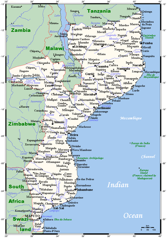
Capital
- MaputoMaputoMaputo, also known as Lourenço Marques, is the capital and largest city of Mozambique. It is known as the City of Acacias in reference to acacia trees commonly found along its avenues and the Pearl of the Indian Ocean. It was famous for the inscription "This is Portugal" on the walkway of its...
(Lourenço Marques)
Major Cities
- MatolaMatolaMatola is a city in southern Mozambique, which lies 12 kilometers to the west of the country's capital, Maputo. Matola is the capital of Maputo Province and has had its own elected municipal government since 1998. It has a port and also the biggest industrial area in Mozambique...
- NampulaNampulaNampula is the capital city of Nampula Province in Mozambique.It has a population of 471,717 making it the third largest city in Mozambique after Maputo and Beira. It is home to the Mozambique National Ethnographic Museum, several markets, cathedrals and mosques.It is also the center of business...
- BeiraBeira, MozambiqueBeira is the second largest city in Mozambique. It lies in the central region of the country in Sofala Province, where the Pungue River meets the Indian Ocean. Beira had a population of 412,588 in 1997, which grew to an estimated 546,000 in 2006...
- ChimoioChimoioChimoio is the capital of Manica Province in Mozambique. It is the fifth-largest city in Mozambique.Chimoio's name under Portuguese administration was Vila Pery. Vila Pery developed under Portuguese rule as an important agricultural and textiles centre.The town lies on the railway line from Beira...
- NacalaNacalaNacala, also known as Cidade de Nacala or Nacala-Porto is on the northern coast of Mozambique is the deepest natural port on the east coast of Africa. It serves as the terminal for the Nacala Railway, a rail link to the landlocked Malawi...
- QuelimaneQuelimaneQuelimane is a seaport in Mozambique. It is the administrative capital of the Zambezia Province and the province's largest city, and stands 25 km from the mouth of the Rio dos Bons Sinais . The river was named when Vasco da Gama, on his way to India, reached it and saw "good signs" that he was on...
- TeteTete-External links:* *...
- LichingaLichingaLichinga is the capital city of Niassa Province of Mozambique. It lies on the Lichinga Plateau at an altitude of 1360 metre, east of Lake Niassa . The town was founded as Vila Cabral as a farming and military settlement...
- PembaPemba, MozambiquePemba is a port city in Mozambique. It is the capital of the province of Cabo Delgado and lies on a peninsula in Pemba Bay.The town was founded by the Niassa Company in 1904 as Porto Amélia, after a queen of Portugal, at the peninsula's south western tip and has grown around a port. The city is...
(Porto Amelia)
Other Cities
- AngocheAngocheAngoche is a city of Nampula Province in Mozambique. The city was named António Enes until 1976, after the 19th century Portuguese journalist and colonial administrator, António José Enes...
(António Enes)
Area - comparative:
Belarus
Belarus
Belarus , officially the Republic of Belarus, is a landlocked country in Eastern Europe, bordered clockwise by Russia to the northeast, Ukraine to the south, Poland to the west, and Lithuania and Latvia to the northwest. Its capital is Minsk; other major cities include Brest, Grodno , Gomel ,...
: slightly less than four times the size of Belarus
Belarus
Belarus , officially the Republic of Belarus, is a landlocked country in Eastern Europe, bordered clockwise by Russia to the northeast, Ukraine to the south, Poland to the west, and Lithuania and Latvia to the northwest. Its capital is Minsk; other major cities include Brest, Grodno , Gomel ,...
.
Kyrgyzstan
Kyrgyzstan
Kyrgyzstan , officially the Kyrgyz Republic is one of the world's six independent Turkic states . Located in Central Asia, landlocked and mountainous, Kyrgyzstan is bordered by Kazakhstan to the north, Uzbekistan to the west, Tajikistan to the southwest and China to the east...
: slightly more than four times the size of Kyrgyzstan
Kyrgyzstan
Kyrgyzstan , officially the Kyrgyz Republic is one of the world's six independent Turkic states . Located in Central Asia, landlocked and mountainous, Kyrgyzstan is bordered by Kazakhstan to the north, Uzbekistan to the west, Tajikistan to the southwest and China to the east...
.
Iran
Iran
Iran , officially the Islamic Republic of Iran , is a country in Southern and Western Asia. The name "Iran" has been in use natively since the Sassanian era and came into use internationally in 1935, before which the country was known to the Western world as Persia...
: slightly less than half the size of Iran
Iran
Iran , officially the Islamic Republic of Iran , is a country in Southern and Western Asia. The name "Iran" has been in use natively since the Sassanian era and came into use internationally in 1935, before which the country was known to the Western world as Persia...
.
Pakistan
Pakistan
Pakistan , officially the Islamic Republic of Pakistan is a sovereign state in South Asia. It has a coastline along the Arabian Sea and the Gulf of Oman in the south and is bordered by Afghanistan and Iran in the west, India in the east and China in the far northeast. In the north, Tajikistan...
: slightly less than the size of Pakistan
Pakistan
Pakistan , officially the Islamic Republic of Pakistan is a sovereign state in South Asia. It has a coastline along the Arabian Sea and the Gulf of Oman in the south and is bordered by Afghanistan and Iran in the west, India in the east and China in the far northeast. In the north, Tajikistan...
.
Paraguay
Paraguay
Paraguay , officially the Republic of Paraguay , is a landlocked country in South America. It is bordered by Argentina to the south and southwest, Brazil to the east and northeast, and Bolivia to the northwest. Paraguay lies on both banks of the Paraguay River, which runs through the center of the...
: slightly less than twice the size of Paraguay
Paraguay
Paraguay , officially the Republic of Paraguay , is a landlocked country in South America. It is bordered by Argentina to the south and southwest, Brazil to the east and northeast, and Bolivia to the northwest. Paraguay lies on both banks of the Paraguay River, which runs through the center of the...
.
United States
United States
The United States of America is a federal constitutional republic comprising fifty states and a federal district...
: slightly less than twice the size of California
California
California is a state located on the West Coast of the United States. It is by far the most populous U.S. state, and the third-largest by land area...
.
Zimbabwe
Zimbabwe
Zimbabwe is a landlocked country located in the southern part of the African continent, between the Zambezi and Limpopo rivers. It is bordered by South Africa to the south, Botswana to the southwest, Zambia and a tip of Namibia to the northwest and Mozambique to the east. Zimbabwe has three...
: slightly more than twice the size of Zimbabwe
Zimbabwe
Zimbabwe is a landlocked country located in the southern part of the African continent, between the Zambezi and Limpopo rivers. It is bordered by South Africa to the south, Botswana to the southwest, Zambia and a tip of Namibia to the northwest and Mozambique to the east. Zimbabwe has three...
.
Land boundaries:
total:
4 571 km
border countries:
Malawi
Malawi
The Republic of Malawi is a landlocked country in southeast Africa that was formerly known as Nyasaland. It is bordered by Zambia to the northwest, Tanzania to the northeast, and Mozambique on the east, south and west. The country is separated from Tanzania and Mozambique by Lake Malawi. Its size...
1 569 km, South Africa 491 km, Swaziland
Swaziland
Swaziland, officially the Kingdom of Swaziland , and sometimes called Ngwane or Swatini, is a landlocked country in Southern Africa, bordered to the north, south and west by South Africa, and to the east by Mozambique...
105 km, Tanzania
Tanzania
The United Republic of Tanzania is a country in East Africa bordered by Kenya and Uganda to the north, Rwanda, Burundi, and the Democratic Republic of the Congo to the west, and Zambia, Malawi, and Mozambique to the south. The country's eastern borders lie on the Indian Ocean.Tanzania is a state...
756 km, Zambia
Zambia
Zambia , officially the Republic of Zambia, is a landlocked country in Southern Africa. The neighbouring countries are the Democratic Republic of the Congo to the north, Tanzania to the north-east, Malawi to the east, Mozambique, Zimbabwe, Botswana and Namibia to the south, and Angola to the west....
419 km, Zimbabwe
Zimbabwe
Zimbabwe is a landlocked country located in the southern part of the African continent, between the Zambezi and Limpopo rivers. It is bordered by South Africa to the south, Botswana to the southwest, Zambia and a tip of Namibia to the northwest and Mozambique to the east. Zimbabwe has three...
1 231 km
Coastline:
2 470 km
Maritime claims:
exclusive economic zone:
200 nmi (370.4 km; 230.2 mi)
territorial sea:
12 nmi (22.2 km; 13.8 mi)
Terrain:
mostly coastal lowlands, uplands in center, high plateaus in northwest, mountains in west
Elevation extremes:
lowest point:
Indian Ocean 0 m
highest point:
Monte Binga
Monte Binga
Binga is the highest mountain in Mozambique. It is located a few kilometres east of the border between Zimbabwe and Mozambique in the Chimanimani Transfrontier Park in the province of Manica. Its height is above sea level....
2 436 m
Natural resources:
coal, titanium, natural gas, hydropower, tantalum, graphite
Land use:
arable land:
5.43% (2005 est.), 3.98% (1998 est.)
permanent crops:
0.29% (2005 est.), 0.29% (1998 est.)
other:
94.28% (2005 est.), 95.73% (1998 est.)
Irrigated land:
1 180 km² (1993 est.)
Natural hazards:
severe droughts; devastating cyclones and floods occur in central and southern provinces
Environment - current issues:
a long civil war and recurrent drought in the hinterlands have resulted in increased migration of the population to urban and coastal areas with adverse environmental consequences; desertification; pollution of surface and coastal waters; elephant poaching for ivory is a problem
Environment - international agreements:
party to:
Biodiversity, Climate Change, Desertification, Endangered Species, Hazardous Wastes, Law of the Sea, Ozone Layer Protection
signed, but not ratified:
none of the selected agreements
Ecoregions
- Eastern Miombo woodlandsEastern Miombo woodlandsThe Eastern Miombo woodlands are an ecoregion of grassland and woodland in southern Tanzania and northern Mozambique.-Setting:These species-rich savanna ecosystems cover wide areas of gentle hills and low valleys containing rivers and dambo wetlands...
- Eastern Zimbabwe montane forest-grassland mosaic
- Maputaland coastal forest mosaicMaputaland coastal forest mosaicThe Maputaland coastal forest mosaic is an ecoregion of the subtropical moist broadleaf forests Biome, in Southern Africa. It covers an area of in southern Mozambique, Swaziland, and the KwaZulu-Natal Province of South Africa. Mozambique's capital Maputo lies within the ecoregion.The Maputaland...
- Southern Miombo woodlands
- Southern Rift montane forest-grassland mosaic
- Southern Zanzibar-Inhambane coastal forest mosaicSouthern Zanzibar-Inhambane coastal forest mosaicSouthern Zanzibar-Inhambane coastal forest mosaic is the southern variation of Northern Zanzibar-Inhambane coastal forest mosaic.The ecoregion which runs from the Lukuledi river in Tanzania almost the whole way to the mouth of the Limpopo river, supports habitats of forest, savanna and swamps...
- Zambezian coastal flooded savanna
- Zambezian flooded grasslandsZambezian flooded grasslandsThe Zambezian flooded grasslands is an ecoregion of southern and eastern Africa that is rich in wildlife.-Setting:The Zambezian flooded grasslands can be found on seasonally or permanently flooded lowlands in the basin of the Zambezi and neighboring river basins...
- Zambezian halophytics
- Zambezian and Mopane woodlands
- East African mangrovesEast African mangrovesThe East African mangroves are an ecoregion consisting of mangrove swamps along the Indian Ocean coast of East Africa in southern Mozambique, Tanzania, Kenya and southern Somalia.-Location and description:...
Climate
Mozambique has a tropical climate with two seasons, a wet season from October to March and a dry season from April to September. Climatic conditions, however, vary depending on altitude. Rainfall is heavy along the coast and decreases in the north and south. Annual precipitation varies from 500 to 900 mm (19.7 to 35.4 in) depending on the region with an average of 590 mm (23.2 in). Cyclones are also common during the wet season. Average temperature ranges in Maputo are from 13 to 24 °C (55.4 to 75.2 F) in July to 22 to 31 °C (71.6 to 87.8 F) in February.Physical Features
The coastline extends from 26° 52' S. to 10° 40' S., and from south to north makes a double curve with a general trend outward to the east. It has a length of 1430 miles (2,301.4 km). Some 40 miles (64 km) north of the South AfricaSouth Africa
The Republic of South Africa is a country in southern Africa. Located at the southern tip of Africa, it is divided into nine provinces, with of coastline on the Atlantic and Indian oceans...
n frontier is the deep indentation of Delagoa Bay. The land then turns outward to Cape Corrientes, a little north of which is Inhambane Bay. Bending westward again and passing the Bazaruto Archipelago
Bazaruto Archipelago
The Bazaruto Archipelago is a group of six islands in Mozambique, near the mainland city of Vilankulo. It comprises the islands of Bazaruto, Benguerra, Magaruque, Banque, Santa Carolina and Shell....
of several small islands, of which the chief is Bazaruto
Bazaruto Island
Bazaruto is a sandy island located approximately southeast of the mouth of the Save River, Mozambique . It is the largest island in the Bazaruto Archipelago and in the Bazaruto National Park....
, Sofala Bay is reached. Northward the Zambezi River with a wide delta
River delta
A delta is a landform that is formed at the mouth of a river where that river flows into an ocean, sea, estuary, lake, reservoir, flat arid area, or another river. Deltas are formed from the deposition of the sediment carried by the river as the flow leaves the mouth of the river...
pours its waters into the ocean. From this point onward the coast is studded with small islands, mainly of coral formation. On one of these islands is Mozambique
Island of Mozambique
The Island of Mozambique lies off northern Mozambique, between the Mozambique Channel and Mossuril Bay. It has a population of around 14,000 people and is part of Nampula Province.-History:...
, and immediately north of that port is Conducia Bay. Somewhat farther north are two large bays, Fernao Veloso and Memba. There is a great difference in the character of the coast north and south of Mozambique. To the north the coast is much indented, abounds in rocky headlands and rugged cliffs while, as already stated, there is an almost continuous fringe of islands.
In southern Mozambique the coastline is low, sandy and contains swamps of East African mangroves
East African mangroves
The East African mangroves are an ecoregion consisting of mangrove swamps along the Indian Ocean coast of East Africa in southern Mozambique, Tanzania, Kenya and southern Somalia.-Location and description:...
. Harbours are few and poor. The difference in character of these two regions arises from the fact that in the northern half the ocean current which flows south between Madagascar
Madagascar
The Republic of Madagascar is an island country located in the Indian Ocean off the southeastern coast of Africa...
and the mainland is close to the coast, and scours out all the softer material, while at the same time the coral
Coral
Corals are marine animals in class Anthozoa of phylum Cnidaria typically living in compact colonies of many identical individual "polyps". The group includes the important reef builders that inhabit tropical oceans and secrete calcium carbonate to form a hard skeleton.A coral "head" is a colony of...
s are building in deep waters. But south of Mozambique the ocean current forsakes the coast, allowing the accumulation of sand and alluvial matter. North of Fernao Veloso and Memba the largest bays are Pemba (where there is commodious anchorage for heavy draught vessels), Montepuesi and Tunghi, the last named having for its northern arm Cape Delgado
Cape Delgado
Cape Delgado, Portuguese Cabo Delgado , is a coastal promontory on the border of Mozambique and Tanzania, and is the northernmost point in Mozambique....
, the northernmost point on Mozambique's coast.
Orographically the backbone of the country is the mountain chain which forms the eastern escarpment of the continental plateau. It does not present a uniformly abrupt descent to the plains, but in places, as in the lower Zambezi district, slopes gradually to the coast. The Lebombo Mountains
Lebombo Mountains
The Lebombo Mountains, also called Lubombo Mountains, are an 800km long, narrow range of mountains in Southern Africa stretching from Hluhluwe in KwaZulu-Natal in the south to Punda Maria in the Limpopo Province in South Africa in the north. Part of the mountains are found in South Africa,...
, behind Delagoa Bay, nowhere exceed 2070 ft (631 m) in height; the Manica Plateau, farther north, is higher. Mt Doe rises to 7875 ft (2,400 m) and Mt Panga to 7610 ft (2,320 m) The Gorongoza massif with Mt Miranga (6550 ft (1,996 m)), Enhatete (6050 ft (1,844 m)), and Gogogo (5900 ft (1,798 m)) lies north-east of the Manica plateau, and is, like it, of granitic formation. Gorongoza, rising isolated with precipitous outer slopes, has been likened in its aspect to a frowning citadel. The chief mountain range, however, lies north of the Zambezi, and east of Lake Chilwa
Lake Chilwa
Lake Chilwa is the second-largest lake in Malawi after Lake Malawi. It is in eastern Zomba District, near the border with Mozambique. Approximately 60 km long and 40 km wide, the lake is surrounded by extensive wetlands....
, namely, the Namuli Mountains, in which Namuli Peak rises to 8860 ft (2,701 m), and Molisani, Mruli and Mresi attain altitudes of 6500 to 8000 ft (1,981.2 to 2,438.4 m) These mountains are covered with magnificent forests. Farther north the river basins are divided by well-marked ranges with heights of 3000 ft (914 m) and over. Near the south-east shore of Lake Malawi
Lake Malawi
Lake Malawi , is an African Great Lake and the southernmost lake in the Great Rift Valley system of East Africa. This lake, the third largest in Africa and the eighth largest lake in the world, is located between Malawi, Mozambique, and Tanzania...
there is a high range (5000 to 6000 ft (1,524 to 1,828.8 m) with an abrupt descent to the lake - some 3000 ft (914 m) in 6 mi (9.7 km). The country between Malawi and Ibo is remarkable for the number of fantastically shaped granite peaks which rise from the plateau.
The plateau lands west of the escarpment are of moderate elevation - perhaps averaging 2000 to 2500 ft (609.6 to 762 m) It is, however, only along the Zambezi and north of that river that Mozambique's territory reaches to the continental plateau. This northern plain has been categorised by the World Wildlife Fund as part of the Eastern Miombo woodlands
Eastern Miombo woodlands
The Eastern Miombo woodlands are an ecoregion of grassland and woodland in southern Tanzania and northern Mozambique.-Setting:These species-rich savanna ecosystems cover wide areas of gentle hills and low valleys containing rivers and dambo wetlands...
ecoregion
Ecoregion
An ecoregion , sometimes called a bioregion, is an ecologically and geographically defined area that is smaller than an ecozone and larger than an ecosystem. Ecoregions cover relatively large areas of land or water, and contain characteristic, geographically distinct assemblages of natural...
.
Besides the Zambezi, the most considerable river in Mozambique is the Limpopo
Limpopo River
The Limpopo River rises in central southern Africa, and flows generally eastwards to the Indian Ocean. It is around long, with a drainage basin in size. Its mean annual discharge is 170 m³/s at its mouth...
which enters the Indian Ocean about 100 miles (161 km) north of Delagoa Bay. The Komati, Save, Busi and Pungwe south of the Zambezi; the Lukugu, Lurio, Montepuesi (Mtepwesi) and Msalu, with the Rovuma and its affluent the Lujenda, to the north of it, are the other rivers of the province with considerable drainage areas. The Save
Save River (Africa)
The Save is a 400km river of southeastern Africa, flowing through Zimbabwe and Mozambique. The river has its source in Zimbabwe, some 80 km south of Harare, then flows south and then east, from the Zimbabwean highveld to its confluence with the Odzi River...
(Sabi) rises in Zimbabwe
Zimbabwe
Zimbabwe is a landlocked country located in the southern part of the African continent, between the Zambezi and Limpopo rivers. It is bordered by South Africa to the south, Botswana to the southwest, Zambia and a tip of Namibia to the northwest and Mozambique to the east. Zimbabwe has three...
at an altitude of over 3000 ft (914 m), and after flowing south for over 200 miles (322 km) turns east and pierces the mountains some 170 miles (274 km) from the coast, being joined near the Zimbabwe-Mozambique frontier by the Lundi. Cataracts entirely prevent navigation above this point. Below the Lundi confluence the bed of the Sabi becomes considerably broader, varying from half a mile to two miles (3 km). In the rainy season the Save is a large stream and even in the " dries " it can be navigated from its mouth by shallow draught steamers for over 150 m. Its general direction through Portuguese territory is east by north. At its mouth it forms a delta 60 miles (97 km) in extent. The Busi (220 m) and Pungwe (180 m) are streams north of and similar in character to the Save. They both rise in the Manica plateau and enter the ocean in Pungwe Bay, their mouths a mile or two apart. The lower reaches of both streams are navigable, the Busi for 25 miles (40 km), the Pungwe for about 2 miles (3.2 km). At the mouth of the Pungwe is the port of Beira
Beira, Mozambique
Beira is the second largest city in Mozambique. It lies in the central region of the country in Sofala Province, where the Pungue River meets the Indian Ocean. Beira had a population of 412,588 in 1997, which grew to an estimated 546,000 in 2006...
. Of the north-Zambezi streams the Lukugu, rising in the hills south-east of Lake Chilwa, flows south and enters the ocean not far north of Quelimane
Quelimane
Quelimane is a seaport in Mozambique. It is the administrative capital of the Zambezia Province and the province's largest city, and stands 25 km from the mouth of the Rio dos Bons Sinais . The river was named when Vasco da Gama, on his way to India, reached it and saw "good signs" that he was on...
. The Lurio, rising in the Namuli Mountains, flows north-east, having a course of some 200 miles (322 km). The Montepuesi and the Msalu drain the country between the Lurio and Rovuma basins. Their banks are in general well defined and the wet season rise seems fairly constant.
Extreme points
This is a list of the extreme points of MozambiqueMozambique
Mozambique, officially the Republic of Mozambique , is a country in southeastern Africa bordered by the Indian Ocean to the east, Tanzania to the north, Malawi and Zambia to the northwest, Zimbabwe to the west and Swaziland and South Africa to the southwest...
, the points that are farther north, south, east or west than any other location.
- Northernmost point - Cape DelgadoCape DelgadoCape Delgado, Portuguese Cabo Delgado , is a coastal promontory on the border of Mozambique and Tanzania, and is the northernmost point in Mozambique....
, Cabo Delgado Province - Easternmost point - unnamed headland east of the village of Amade, Nampula ProvinceNampula ProvinceNampula is a province of Mozambique. It has an area of 81,606 km² and a population of 3.985.285 . Nampula is the capital of the province...
- Southernmost point - unnamed location on the border with South AfricaSouth AfricaThe Republic of South Africa is a country in southern Africa. Located at the southern tip of Africa, it is divided into nine provinces, with of coastline on the Atlantic and Indian oceans...
east of the South African town of Mosi, Maputo ProvinceMaputo ProvinceMaputo is a province of Mozambique; the province excludes the city of Maputo . The province has an area of 26,058 km² and a population of 1,072,086 .Matola is the capital of the province.... - Westernmost point - the point where the border with ZambiaZambiaZambia , officially the Republic of Zambia, is a landlocked country in Southern Africa. The neighbouring countries are the Democratic Republic of the Congo to the north, Tanzania to the north-east, Malawi to the east, Mozambique, Zimbabwe, Botswana and Namibia to the south, and Angola to the west....
enters the Luangwa riverLuangwa RiverThe Luangwa River is one of the major tributaries of the Zambezi River, and one of the four biggest rivers of Zambia. The river generally floods in the rainy season and then falls considerably in the dry season...
, Tete ProvinceTete ProvinceTete is a province of Mozambique. It has an area of 100,724 km² and a population of approximately 1.551.949 .Tete is the capital of the province...
External links
- Mozambique Geography from Southern Africa Places
- Mozambique page from World Travel Guide
- Mozambique - Geography and Environment from Oxfam's "Cool Planet"
- Integrated geological interpretation of remotely sensed data to support geological mapping in Mozambique