
Geography of Guadeloupe
Encyclopedia
Guadeloupe
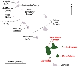
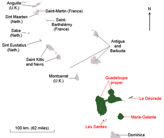
Guadeloupe is an archipelago located in the Leeward Islands, in the Lesser Antilles, with a land area of 1,628 square kilometres and a population of 400,000. It is the first overseas region of France, consisting of a single overseas department. As with the other overseas departments, Guadeloupe...
comprises five island
Island
An island or isle is any piece of sub-continental land that is surrounded by water. Very small islands such as emergent land features on atolls can be called islets, cays or keys. An island in a river or lake may be called an eyot , or holm...
s: Guadeloupe island composed of Basse-Terre Island
Basse-Terre Island
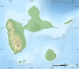
Basse-Terre Island is the name of the western-half of Guadeloupe proper, in the Lesser Antilles. It is separated from the other half of Guadeloupe proper, Grande-Terre, by a narrow sea channel called the Rivière Salée ....
and Grande-Terre
Grande-Terre
Grande-Terre is an island in the Guadeloupe, separated by Basse-Terre Island by a salt river. Grande-Terre's northernmost point, Pointe de la Grande Vigie, is also the northernmost point in Guadeloupe....
(separated from Basse-Terre by a narrow sea channel called salt river) and the dependences
Dependence of Guadeloupe
The dependences of Guadeloupe are the French islands connected with the overseas department of Guadeloupe. They are nearby island entities in the South and east of Guadeloupe island...
composed by the adjacent french islands of La Désirade
La Désirade
La Désirade is a French West Indies island located at the eastern of Guadeloupe, in the Lesser Antilles.It has a land area of 20.64 km² and a population of 1,595 in 2006 , with a population density of 77 inh. per km² in 2006...
, Les Saintes and Marie-Galante
Marie-Galante
Marie-Galante is an island of the Caribbean Sea located at the south of Guadeloupe and at north of Dominica. Marie-Galante is a dependence of Guadeloupe which is a french overseas department....
. Basse-Terre has a rough volcanic relief whilst Grande-Terre features rolling hills and flat plains. Guadeloupe was formed from multiple volcanoes, of which only Basse-Terre is not extinct.
Further to the north, Saint-Barthélemy and the French part of Saint Martin
Saint Martin
Saint Martin is an island in the northeast Caribbean, approximately east of Puerto Rico. The 87 km2 island is divided roughly 60/40 between France and the Kingdom of the Netherlands ; however, the Dutch side has the larger population. It is one of the smallest sea islands divided between...
come under the jurisdiction of Guadeloupe. On December 7, 2003, both of these areas voted to become an overseas territorial collectivity.
Hurricanes
- On 12 September, 1928 Okeechobee hurricane1928 Okeechobee HurricaneThe Okeechobee hurricane, or San Felipe Segundo hurricane, was a deadly hurricane that struck the Leeward Islands, Puerto Rico, the Bahamas, and Florida in September of the 1928 Atlantic hurricane season...
caused extensive damage and killed thousands of people. - On 22 August 1964, Guadeloupe was ravaged by Hurricane CleoHurricane CleoHurricane Cleo was the third named storm, first hurricane, and first major hurricane of the 1964 Atlantic hurricane season. Cleo was one of the longest-lived storms of the season...
, which killed 14 people. - Two years later, on 27 September 1966, Hurricane InezHurricane InezHurricane Inez was a deadly, destructive, powerful and very long-lived Cape Verde-type hurricane that carved an erratic path through the Lesser Antilles, Hispaniola, Cuba, the Bahamas, Florida, and Mexico in 1966...
caused extensive damage and killed 27 people, mostly in Grande-Terre. Charles De GaulleCharles de GaulleCharles André Joseph Marie de Gaulle was a French general and statesman who led the Free French Forces during World War II. He later founded the French Fifth Republic in 1958 and served as its first President from 1959 to 1969....
visited the island after the hurricanes and declared it a disaster area. - On 17 September 1989, Category 4 Hurricane HugoHurricane HugoHurricane Hugo was a classical, destructive and rare Cape Verde-type hurricane which struck the Caribbean islands of Guadeloupe, Montserrat, St. Croix, Puerto Rico and the USA mainland in South Carolina as a Category 4 hurricane during September of the 1989 Atlantic hurricane season...
caused very extensive damage, left more than 35,000 homeless, destroyed 10,000 homes, 100 percent of the banana crops, and 60 percent of the sugar cane crops. - From late August to mid September 1995, the island was in the path of three successive cyclones: Tropical Storm IrisHurricane Iris (1995)Hurricane Iris was the ninth named tropical cyclone and fifth hurricane of an active 1995 Atlantic hurricane season. Iris was one of four storms to form nearly simultaneously in the Atlantic during the 1995 season. Forming on August 22, Iris slowly drifted across the Leeward Islands as a tropical...
on 28 August caused minor damages; Hurricane LuisHurricane LuisHurricane Luis was one of the deadliest and most destructive hurricanes of the 1995 Atlantic hurricane season, with maximum sustained winds of 140 mph . The storm was the twelfth tropical storm, sixth hurricane, and second major hurricane of the season...
on 5 September caused moderate damages in north coast of Grande-Terre; Hurricane MarilynHurricane MarilynHurricane Marilyn was the fifteenth tropical depression and thirteenth named storm of the unusually busy 1995 Atlantic hurricane season, following closely on the heels of Hurricane Luis. Hurricane Marilyn was the most powerful storm to hit the Virgin Islands since Hurricane Hugo of 1989.Marilyn...
on 15 September caused moderate damages in Basse-Terre. - On 20 September 1998, Hurricane GeorgesHurricane GeorgesHurricane Georges was a very destructive, powerful and long-lived Cape Verde-type Category 4 hurricane. Georges was the seventh tropical storm, fourth hurricane, and second major hurricane of the 1998 Atlantic hurricane season...
pounded the islands, decimated the banana crops at nearly 100%.
Statistics
Location:- CaribbeanCaribbeanThe Caribbean is a crescent-shaped group of islands more than 2,000 miles long separating the Gulf of Mexico and the Caribbean Sea, to the west and south, from the Atlantic Ocean, to the east and north...
, islandIslandAn island or isle is any piece of sub-continental land that is surrounded by water. Very small islands such as emergent land features on atolls can be called islets, cays or keys. An island in a river or lake may be called an eyot , or holm...
s in the eastern Caribbean SeaCaribbean SeaThe Caribbean Sea is a sea of the Atlantic Ocean located in the tropics of the Western hemisphere. It is bounded by Mexico and Central America to the west and southwest, to the north by the Greater Antilles, and to the east by the Lesser Antilles....
, southeast of Puerto RicoPuerto RicoPuerto Rico , officially the Commonwealth of Puerto Rico , is an unincorporated territory of the United States, located in the northeastern Caribbean, east of the Dominican Republic and west of both the United States Virgin Islands and the British Virgin Islands.Puerto Rico comprises an...
.
Geographic coordinates:
- 16°15′N 61°35′W
Map references:
- Central AmericaCentral AmericaCentral America is the central geographic region of the Americas. It is the southernmost, isthmian portion of the North American continent, which connects with South America on the southeast. When considered part of the unified continental model, it is considered a subcontinent...
and the Caribbean
Area:
- Total:
- Land:
- Water:
- Note: Guadeloupe department is composed of six inhabited islands: the main islands which formed Guadeloupe island: Basse-Terre IslandBasse-Terre IslandBasse-Terre Island is the name of the western-half of Guadeloupe proper, in the Lesser Antilles. It is separated from the other half of Guadeloupe proper, Grande-Terre, by a narrow sea channel called the Rivière Salée ....
on the west and Grande-TerreGrande-TerreGrande-Terre is an island in the Guadeloupe, separated by Basse-Terre Island by a salt river. Grande-Terre's northernmost point, Pointe de la Grande Vigie, is also the northernmost point in Guadeloupe....
on the east, and the nearby smaller islands : Marie-GalanteMarie-GalanteMarie-Galante is an island of the Caribbean Sea located at the south of Guadeloupe and at north of Dominica. Marie-Galante is a dependence of Guadeloupe which is a french overseas department....
, La DesiradeLa DésiradeLa Désirade is a French West Indies island located at the eastern of Guadeloupe, in the Lesser Antilles.It has a land area of 20.64 km² and a population of 1,595 in 2006 , with a population density of 77 inh. per km² in 2006...
, Iles des SaintesÎles des SaintesThe Îles des Saintes , also called simply Les Saintes , is a small archipelago of French Antilles located in the South of Basse-Terre Island, on the West of Marie-Galante and in the North of Dominica in the arc of Lesser Antilles...
(Terre-de-Haut island and Terre-de-Bas island).
Area – comparative:
- 10 times the size of Washington, DC
Coastline:
Maritime claims:
- Exclusive economic zone:
- Territorial sea:
Climate:
- Tropical tempered by trade winds; moderately high humidity
Terrain:
- Basse-Terre is volcanic in origin with interior mountains; Grande-Terre is low limestone formation; most of the seven other islands are volcanic in origin
Elevation extremes:
- Lowest point: Caribbean Sea 0 m
- Highest point: La Grande SoufrièreLa Grande SoufrièreLa Grande Soufrière, , is an active stratovolcano located on the French island of Basse-Terre, in Guadeloupe. It is the tallest mountain in the Lesser Antilles, and rises 1,467 m high....
-
Natural resources:
- Cultivable land, beaches and climate that foster tourism
Land use:
- Arable land: 14%
- Permanent crops: 4%
- Permanent pastures: 14%
- Forests and woodland: 39%
- Other: 29% (1993 est.)
Irrigated land:
- 30 km2 or 12 sq mi (1993 est.)
Natural hazards:
- Hurricanes (June to October); La Grande SoufrièreLa Grande SoufrièreLa Grande Soufrière, , is an active stratovolcano located on the French island of Basse-Terre, in Guadeloupe. It is the tallest mountain in the Lesser Antilles, and rises 1,467 m high....
is an active volcano
Environment – current issues:
- NA