

Marie-Galante
Encyclopedia
Caribbean Sea
The Caribbean Sea is a sea of the Atlantic Ocean located in the tropics of the Western hemisphere. It is bounded by Mexico and Central America to the west and southwest, to the north by the Greater Antilles, and to the east by the Lesser Antilles....
located at the south of Guadeloupe
Guadeloupe
Guadeloupe is an archipelago located in the Leeward Islands, in the Lesser Antilles, with a land area of 1,628 square kilometres and a population of 400,000. It is the first overseas region of France, consisting of a single overseas department. As with the other overseas departments, Guadeloupe...
and at north of Dominica
Dominica
Dominica , officially the Commonwealth of Dominica, is an island nation in the Lesser Antilles region of the Caribbean Sea, south-southeast of Guadeloupe and northwest of Martinique. Its size is and the highest point in the country is Morne Diablotins, which has an elevation of . The Commonwealth...
. Marie-Galante is a dependence of Guadeloupe which is a french overseas department.
The superficy of the island of Marie-Galante is about 158 km² (61 sq. miles). Its population counts 12,009 inhabitants on 2006 census (down from 16,341 inhabitants at the 1961 census). The population density in 2006 was 76 inh. per km².
Administration
Marie-Galante is divided in three communes: Grand-BourgGrand-Bourg
Grand-Bourg is a commune on the island of Marie-Galante, in the French overseas region and department of Guadeloupe in the Lesser Antilles Caribbean. It is located in the southwest of Marie-Galante, and is the most populous of the three communes on the island....
(5,707 inhabitants), Capesterre-de-Marie-Galante
Capesterre-de-Marie-Galante
Capesterre-de-Marie-Galante is a commune on the island of Marie-Galante, in the French overseas region and department of Guadeloupe, itself in the Lesser Antilles....
(3,469 inhabitants), and Saint-Louis
Saint-Louis, Guadeloupe
Saint-Louis is a commune in the overseas department of Guadeloupe. Saint-Louis lies on the north of the island of Marie-Galante, and is the island's largest commune. Many beaches lie on the west coast of the commune.-External links:...
(2,833 inhabitants).
The three communes of Marie-Galante formed an intercommunal entity in 1994: the Community of Communes of Marie-Galante (French
French language
French is a Romance language spoken as a first language in France, the Romandy region in Switzerland, Wallonia and Brussels in Belgium, Monaco, the regions of Quebec and Acadia in Canada, and by various communities elsewhere. Second-language speakers of French are distributed throughout many parts...
: Communauté de communes de Marie-Galante). This is the oldest intercommunal structure in overseas France.
History
The Huecoids is the oldest known civilization to have occupied Marie Galante. The Arawak tribe followed them. Then around AD 850 the Carib Indians arrived. Marie Galante was the first island reached by Christopher ColumbusChristopher Columbus
Christopher Columbus was an explorer, colonizer, and navigator, born in the Republic of Genoa, in northwestern Italy. Under the auspices of the Catholic Monarchs of Spain, he completed four voyages across the Atlantic Ocean that led to general European awareness of the American continents in the...
during his second voyage. He arrived at the place called Anse Ballet in Grand-Bourg on November 3, 1493. He named the island after his flagship, Maria Galante. It was previously called "Aichi" by the Carib Indians and "Touloukaera" by the Arawaks.
On November 8, 1648, Governor Houel organized the settlement of the first French colonists, they were about fifty men near the site of Vieux-Fort in Saint Louis. Jacques de Boisseret bought the island back from the French Company of the Islands of America on September 4, 1649. In 1653 the Carib Indians slaughtered the few remaining colonists, who had not given into the harsh living conditions, as reprisal for rapes committed on the island of Dominica by sailors on a barge coming from Martinique.
Sugar cane most probably originated from India and had been imported to the French West Indies by Christopher Columbus. In light of its industrialization, it was cultivated in Guadeloupe in the beginning of 1654 thanks to deported Brazilian colonists who incited the creation of the first sugar plantations equipped with small oxen-powered mills to crush the cane.
In 1660, at Basse-Terre Chateau, a peace treaty was signed between the Carib Indians and the French and British who authorized them to settle on the islands of Dominica and Saint Vincent. The Island was now at peace leaving way for human and technological means to unite, developing the economic market based on plantations as the center of production and labor by imported African slaves.
In 1664, Madame de Boisseret gave up her rights to Marie-Galante to the Company of the West Indies, and the Island then had its first four (oxen-powered) mills. In 1665, her son, Monsieur de Boisseret de Temericourt became governor. The map of the island he established carries his coat of arms. The Island was plundered by both the Dutch in 1676, and by the British in 1690 and 1691. These raids, which resulted in the destruction of the mills, the refineries and the depopulation of the Island, caused the Governor-General of Martinique to forbid the re-population of the Island until 1696. The British took over the Island again from 1759 to 1763.
Windmills were first seen in 1780. By 1830, 105 mills existed, half of which were still oxen- drawn. Today 72 mill towers are still standing. From November 1792 to 1794, Marie Galante, which was Republican
French First Republic
The French First Republic was founded on 22 September 1792, by the newly established National Convention. The First Republic lasted until the declaration of the First French Empire in 1804 under Napoleon I...
, separated itself from the royalist government of Guadeloupe. Slavery, first abolished in 1794 then reinstated in 1802, finally came to an end in 1848, thanks to the combined efforts of abolitionists, such as Victor Schoelcher, and repeated Negro slave revolts.
The legislative elections of June 24 and June 25, 1849, the first time former slaves were permitted to vote, were marred by bloody suppression of protesting groups. These groups rose up out of the black majority of the population in response to ballot-rigging orchestrated by wealthy white plantation owners. Many black people were killed during these uprisings which lead to the dumping of rum and sugar from the Pirogue plantation into a nearby pond. Today this pond is known as "la mare au punch" (Punch pond) in memory of these tragic events.
Guadeloupe (Grande-Terre and Basse-Terre), and its dependences Marie-Galante, Saint-Martin, Saint-Barthelemy, Les Saintes (Terre de Haut and Terre de Bas) and la Désirade
La Désirade
La Désirade is a French West Indies island located at the eastern of Guadeloupe, in the Lesser Antilles.It has a land area of 20.64 km² and a population of 1,595 in 2006 , with a population density of 77 inh. per km² in 2006...
has been an overseas French department since 1946 and a single-department region since 1982. (In 2007 Saint Barthelemy
Saint Barthélemy
Saint Barthélemy , officially the Territorial collectivity of Saint Barthélemy , is an overseas collectivity of France. Often abbreviated to Saint-Barth in French, or St. Barts in English, the indigenous people called the island Ouanalao...
and the French part of Saint Martin
Saint Martin
Saint Martin is an island in the northeast Caribbean, approximately east of Puerto Rico. The 87 km2 island is divided roughly 60/40 between France and the Kingdom of the Netherlands ; however, the Dutch side has the larger population. It is one of the smallest sea islands divided between...
both became separate administrative units, however it is expected that until 2012 they will be represented in the French Parliament by Guadeloupe.) The three administrative counties of Marie Galante are Capesterre, Grand-Bourg and Saint Louis. These were designated a county community (Communeauté des Communes) on January 8, 1994, the first to be created in a French Overseas department.
Geography
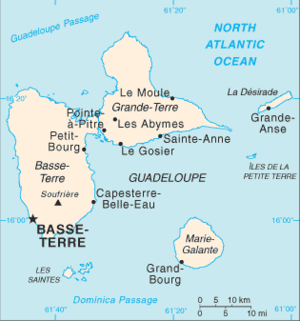
With an area of 158.01 km² (61.01 sq mi), the island comprises three communes with a combined 1999 census population of 12,488 inhabitants. The island is more commonly known as "La grande galette" (Big Cookie) due to its round shape and almost flat surface (its highest peak, the hill Morne Constant, rises to 670 ft). Once counting over 106 sugar mills, it is also called the "Island of a hundred windmills", or the "Grande dependence" (the biggest island depending on Guadeloupe). The island is undulating substrate calcareous, fanned by the trade winds and subject to cyclones and earthquakes.The northern coast is characterized by a high cliff. A fault called the "Bar" separates the northern quarter from the remainder of the island. To the west beaches and mangroves extend along the Caribbean Sea. The rivers of Saint-Louis and the Vieux-Fort run out there after having crossed the insular plate originating at the center of Marie-Galante. In the east and the south, the plate becomes dull to rock inclined towards a littoral plain. This one skirts the Atlantic from which it is protected by a coral barrier.
Economy
The colonial economy developed on the island the cultures of tobacco, indigo, coffee and cotton. But as of the 17th century, sugar cane became a very important source of income. It was maintained into the 19th century and 20th century, adapting to the abolition of slavery and the great sugar crisis.During the dominance of the sugar cane industry, Marie-Galante acquired the nickname "the island with a hundred mills". In 1818 there were over one hundred mills to process sugar cane. The cane juice was transformed into sugar or rum. The mills were originally powered by oxen, after 1883 steam powered mills replaced oxen.
The 19th century brought the disappearance of the economic organization of the old days. Gradually, all the small sugar refineries were restructured into sugar factories. In 1885, five sites controlled the activity. In 1931, 18 sugar distilleries and four factories were in production. The large plantations made accommodations with small farms, organized in the 20th century around co-operatives. But agriculture in all the French West Indies is subject to strong international competition. At the beginning of the 21st century, one sugar refinery (factory of Large Handle) and three distilleries (Bellevue, Rod, Poisson) remain on Marie-Galante. The white rum which is produced there is the subject to a label of origin. The biological sugar production could also be an innovative development, but the current political impetus to end European subsidies puts the future of agriculture in jeopardy and thus threatens the economic future of Marie-Galante and its inhabitants.
Remains of the old economy still exist. This historical richness is a new development for tourism: a nature trail with some 70 turns including two restored mills (Mill of Bézard), colonial dwellings and old sugar refineries (Murat Dwelling) produces a network of paths for hikers to discover the island and its people.
Marie-Galante has thus experienced, like the other islands of Guadeloupe, the economic changes accompanying tourism. But the development of this industry is based on a policy of nature conservation and inheritance, whether it is precolombian, colonial or contemporary. Unfortunately, Marie-Galante Airport is located on Pointe des Basses, halfway between Grand-Bourg and Capesterre, thus making access difficult.
Demography
Marie-Galante counted 30,000 inhabitants in 1946. Strongly marked by the massive exodus of its young people towards Guadeloupe and France, the island counted fewer than 12,009 inhabitants in the 2006 census. This fall of the population is related to the decrease in the sugar cane economy. The population density in 2006 was 76 persons per km².Famous Marie-Galantais
- Constant of Aubigné, (1585–1647), was the governor, of Marie-Galante. His daughter Francoise d' Aubigné accompanied it. Several years afterwards, it was going to become Madam de Maintenon but, of its stay in the Antilles, will remain to him the nickname of Beautiful Indian.
- Charles-François Bonneville, (1803–?), was a mayor and adviser general of Grand-Bourg of 1854 to 1860. Also president of the Room of Agriculture, he is the craftsman of the revival of the culture of cotton long silk which he tries out on the Thibault dwelling.
- Armand Baptiste, the premier Guadeloupean sculptor, resides on Marie-Galante.