

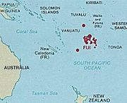
Geography of Fiji
Encyclopedia
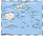
Fiji is a group of volcanic
Volcano
2. Bedrock3. Conduit 4. Base5. Sill6. Dike7. Layers of ash emitted by the volcano8. Flank| 9. Layers of lava emitted by the volcano10. Throat11. Parasitic cone12. Lava flow13. Vent14. Crater15...
island
Island
An island or isle is any piece of sub-continental land that is surrounded by water. Very small islands such as emergent land features on atolls can be called islets, cays or keys. An island in a river or lake may be called an eyot , or holm...
s in the South Pacific
Pacific Ocean
The Pacific Ocean is the largest of the Earth's oceanic divisions. It extends from the Arctic in the north to the Southern Ocean in the south, bounded by Asia and Australia in the west, and the Americas in the east.At 165.2 million square kilometres in area, this largest division of the World...
, lying about 4,450 km (2,775 mi) southwest of Honolulu
Honolulu, Hawaii
Honolulu is the capital and the most populous city of the U.S. state of Hawaii. Honolulu is the southernmost major U.S. city. Although the name "Honolulu" refers to the urban area on the southeastern shore of the island of Oahu, the city and county government are consolidated as the City and...
and 1,770 km (1,100 mi) north of New Zealand
New Zealand
New Zealand is an island country in the south-western Pacific Ocean comprising two main landmasses and numerous smaller islands. The country is situated some east of Australia across the Tasman Sea, and roughly south of the Pacific island nations of New Caledonia, Fiji, and Tonga...
. Of the 322 islands and 522 smaller islets making up the archipelago
Archipelago
An archipelago , sometimes called an island group, is a chain or cluster of islands. The word archipelago is derived from the Greek ἄρχι- – arkhi- and πέλαγος – pélagos through the Italian arcipelago...
, about 106 are permanently inhabited. Viti Levu
Viti Levu
Viti Levu is the largest island in the Republic of Fiji, the site of the nation's capital, Suva, and home to a large majority of Fiji's population.- Geography and economy :...
, the largest island, covers about 57 % of the nation's land area, hosts the two official cities
Local government of Fiji
Fiji is divided administratively into four divisions, which are further subdivided into fourteen provinces; the self-governing island of Rotuma and its dependencies lie outside any of the four divisions. Each division is headed by a Commissioner, appointed by the Fijian government...
(the capital Suva
Suva
Suva features a tropical rainforest climate under the Koppen climate classification. The city sees a copious amount of precipitation during the course of the year. Suva averages 3,000 mm of precipitation annually with its driest month, July averaging 125 mm of rain per year. In fact,...
, and Lautoka
Lautoka
Lautoka is the second largest city of Fiji and the second largest in the South Pacific. It is in the west of the island of Viti Levu, 24 kilometres north of Nadi, and is the second port of entry in Fiji, after Suva. Lying in the heart of Fiji's sugar cane growing region, it is known as the Sugar...
) and most other major towns, such as Ba, Nasinu
Nasinu
Nasinu is an urban area on the island Viti Levu in Fiji. It is officially designated a "Town" despite its population . Nasinu is the most populous municipality in Fiji, having overtaken that of Suva , and is one of Fiji's fastest-growing towns...
, and Nadi
Nadi
Nadi is the third-largest conurbation in Fiji. It is located on the western side of the main island of Viti Levu, and had a population of 42,284 at the most recent census, in 2007. Nadi is multiracial with many of its inhabitants Indian or Fijian, along with a large transient population of foreign...
(the site of the international airport), and contains some 69 % of the population. Vanua Levu
Vanua Levu
Vanua Levu , formerly known as Sandalwood Island, is the second largest island of Fiji. Located 64 kilometres to the north of the larger Viti Levu, the island has an area of 5,587.1 km² and a population of some 130,000.- Geography :...
, 64 km to the north of Viti Levu, covers just over 30 % of the land area though is home to only some 15 % of the population. Its main towns are Labasa
Labasa
Labasa is a town in Fiji with a population of 27,949 at the most recent census held in 2007.Labasa is located in Macuata Province, in the north-eastern part of the island of Vanua Levu, and is the largest town on the island. The town itself is located on a delta formed by three rivers - the...
and Savusavu
Savusavu
Savusavu is a town in the Fijian Province of Cakaudrove. The town is located on the south coast of Vanua Levu Island and had a population of 3,372 in the 2007 census.Savusavu is known as "the hidden paradise of Fiji."- Geography :...
. In the northeast it features Natewa Bay, carving out the Loa
Loa
The Loa are the spirits of the voodoo religion practiced in Louisiana, Haiti, Benin, and other parts of the world. They are also referred to as Mystères and the Invisibles, in which are intermediaries between Bondye —the Creator, who is distant from the world—and humanity...
peninsula.
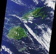
Both islands are mountainous, with peaks up to 1300 m rising abruptly from the shore, and covered with tropical forests. Heavy rains (up to 304 cm or 120 inches annually) fall on the windward (southeastern) side, covering these sections of the islands with dense tropical forest. Lowland
Lowland
In physical geography, a lowland is any broad expanse of land with a general low level. The term is thus applied to the landward portion of the upward slope from oceanic depths to continental highlands, to a region of depression in the interior of a mountainous region, to a plain of denudation, or...
s on the western portions of each of the main islands are sheltered by the mountains and have a well-marked dry season
Dry season
The dry season is a term commonly used when describing the weather in the tropics. The weather in the tropics is dominated by the tropical rain belt, which oscillates from the northern to the southern tropics over the course of the year...
favorable to crops such as sugarcane
Sugarcane
Sugarcane refers to any of six to 37 species of tall perennial grasses of the genus Saccharum . Native to the warm temperate to tropical regions of South Asia, they have stout, jointed, fibrous stalks that are rich in sugar, and measure two to six metres tall...
.
Other islands and island groups, which cover just 12.5 % of the land area and house some 16 % of the population, include Taveuni
Taveuni
Taveuni is the third-largest island in Fiji, after Vanua Levu and Viti Levu, with a total land area of 435 square kilometers . The cigar-shaped island, a massive shield volcano which rises from the floor of the Pacific Ocean, is situated 6.5 kilometers to the east of Vanua Levu, across the...
southeast off Vanua Levu
Vanua Levu
Vanua Levu , formerly known as Sandalwood Island, is the second largest island of Fiji. Located 64 kilometres to the north of the larger Viti Levu, the island has an area of 5,587.1 km² and a population of some 130,000.- Geography :...
and Kadavu Island, south off Viti Levu
Viti Levu
Viti Levu is the largest island in the Republic of Fiji, the site of the nation's capital, Suva, and home to a large majority of Fiji's population.- Geography and economy :...
(the third and fourth largest islands respectively), the Mamanuca Group
Mamanuca Islands
The Mamanuca Islands of Fiji are a volcanic archipelago lying to the west of Nadi and to the south of the Yasawa Islands. The group, a popular tourist destination, consists of about 20 islands, but about seven of these are covered by the Pacific Ocean at high tide.Malololailai is the centre of the...
(just off Nadi
Nadi
Nadi is the third-largest conurbation in Fiji. It is located on the western side of the main island of Viti Levu, and had a population of 42,284 at the most recent census, in 2007. Nadi is multiracial with many of its inhabitants Indian or Fijian, along with a large transient population of foreign...
) and Yasawa Group
Yasawa Islands
The Yasawa Group is an archipelago of about 20 volcanic islands in the Western Division of Fiji, with an approximate total area of 135 square kilometers.- Geography :The Yasawa volcanic group consists of six main islands and numerous smaller islets...
(to the north of the Mamanucas), which are popular tourist destinations, the Lomaiviti Group
Lomaiviti
The Lomaiviti archipelago of Fiji consists of seven main islands and a number of smaller ones. They cover a total area of 411 square kilometers, and had a population of 16,461 at the most recent census in 2007...
(just off Suva) with Levuka
Levuka
Levuka is a town on the eastern coast of the Fijian island of Ovalau, in Lomaiviti Province, in the Eastern Division of Fiji. It was formerly the Capital of Fiji. At the census in 2007, the last to date, Levuka town had a population of 1,131 , about half of Ovalau's 8,360 inhabitants...
, the former capital and the only major town on any of the smaller islands, located on the island of Ovalau, and the remote Lau Group
Lau Islands
The Lau Islands of Fiji are situated in the southern Pacific Ocean, just east of the Koro Sea. Of this chain of about one hundred islands and islets, about thirty are inhabited...
over the Koro Sea
Koro Sea
The Koro Sea or Sea of Koro is a sea in the Pacific Ocean between Viti Levu island, Fiji to the west and the Lau Islands to the east, surrounded by the islands of the Fijian archipelago.It is named after Koro Island.- References :...
to the east near Tonga, from which it is separated by the Lakeba Passage.
Two outlying regions are Rotuma
Rotuma
Rotuma is a Fijian dependency, consisting of Rotuma Island and nearby islets. The island group is home to a small but unique indigenous ethnic group which constitutes a recognizable minority within the population of Fiji, known as "Rotumans"...
, 400 km to the north, and the uninhabited coral atoll and cay
Cay
A cay , also spelled caye or key, is a small, low-elevation, sandy island formed on the surface of coral reefs. Cays occur in tropical environments throughout the Pacific, Atlantic and Indian Oceans , where they provide habitable and agricultural land for hundreds of thousands of people...
Ceva-i-Ra or Conway Reef, 450 km to the southwest of main Fiji. Culturally conservative Rotuma with its 2000 people on 44 km2 geographically
Geography
Geography is the science that studies the lands, features, inhabitants, and phenomena of Earth. A literal translation would be "to describe or write about the Earth". The first person to use the word "geography" was Eratosthenes...
belongs to Polynesia
Polynesia
Polynesia is a subregion of Oceania, made up of over 1,000 islands scattered over the central and southern Pacific Ocean. The indigenous people who inhabit the islands of Polynesia are termed Polynesians and they share many similar traits including language, culture and beliefs...
, and enjoys relative autonomy as a Fijian dependency
Dependent territory
A dependent territory, dependent area or dependency is a territory that does not possess full political independence or sovereignty as a State, and remains politically outside of the controlling state's integral area....
.
Fiji Television
Fiji Television
Fiji Television Limited is Fiji's television network. It was founded on 15 June 1994 as the first permanent television broadcasting network in the country, although television had previously been introduced temporarily in October 1991 to broadcast the Rugby World Cup as well as Cricket World Cup....
reported on 21 September 2006 that the Fiji Islands Maritime and Safety Administration (FIMSA), while reviewing its outdated maritime charts, had discovered the possibility that more islands could lie within Fiji's Exclusive Economic Zone
Exclusive Economic Zone
Under the law of the sea, an exclusive economic zone is a seazone over which a state has special rights over the exploration and use of marine resources, including production of energy from water and wind. It stretches from the seaward edge of the state's territorial sea out to 200 nautical...
.
More than half of Fiji's population lives on the island coasts, either in Suva or in smaller urban centers. The interior is sparsely populated because of its rough terrain.
Statistics
Location:- Oceania, island group in the South Pacific Ocean; Geographic coordinates:
- 18°00′S 179°00′E
Map references:
- Oceania
Area:
- Total: 18 274 km²
- Land: 18 274 km²
- Water: 0 km²
Area - comparative:
- Slightly smaller than New JerseyNew JerseyNew Jersey is a state in the Northeastern and Middle Atlantic regions of the United States. , its population was 8,791,894. It is bordered on the north and east by the state of New York, on the southeast and south by the Atlantic Ocean, on the west by Pennsylvania and on the southwest by Delaware...
; slightly less than one third Nova ScotiaNova ScotiaNova Scotia is one of Canada's three Maritime provinces and is the most populous province in Atlantic Canada. The name of the province is Latin for "New Scotland," but "Nova Scotia" is the recognized, English-language name of the province. The provincial capital is Halifax. Nova Scotia is the...
's size; slightly smaller than WalesWalesWales is a country that is part of the United Kingdom and the island of Great Britain, bordered by England to its east and the Atlantic Ocean and Irish Sea to its west. It has a population of three million, and a total area of 20,779 km²...
Land boundaries:
- 0 km
Coastline:
- 1 129 km
Maritime claims:
- Measured from claimed archipelagic baselines
- Continental shelf: 200-m depth or to the depth of exploitation; rectilinear shelf claim added
- Exclusive economic zone: 200 nmNautical mileThe nautical mile is a unit of length that is about one minute of arc of latitude along any meridian, but is approximately one minute of arc of longitude only at the equator...
- Territorial sea: Fiji comprises 12 nm
Climate:
- Tropical marine; only slight seasonal temperature variation
Terrain:
- Mostly mountains of volcanic origin, beaches
Elevation extremes:
- Lowest point: Pacific Ocean 0 m
- Highest point: Mount TomaniviMount TomaniviMount Tomanivi is an extinct volcano located in the northern highlands of Viti Levu. At , Mount Tomanivi is the highest mountain in Fiji. Previously named Mount Victoria, a trail leads to the summit of Tomanivi from the village of Navai. The main river systems, the Rewa, Navua, Sigatoka, and Ba,...
1 324 m
Natural resources:
- TimberTimberTimber may refer to:* Timber, a term common in the United Kingdom and Australia for wood materials * Timber, Oregon, an unincorporated community in the U.S...
, fishFishFish are a paraphyletic group of organisms that consist of all gill-bearing aquatic vertebrate animals that lack limbs with digits. Included in this definition are the living hagfish, lampreys, and cartilaginous and bony fish, as well as various extinct related groups...
, goldGoldGold is a chemical element with the symbol Au and an atomic number of 79. Gold is a dense, soft, shiny, malleable and ductile metal. Pure gold has a bright yellow color and luster traditionally considered attractive, which it maintains without oxidizing in air or water. Chemically, gold is a...
, copperCopperCopper is a chemical element with the symbol Cu and atomic number 29. It is a ductile metal with very high thermal and electrical conductivity. Pure copper is soft and malleable; an exposed surface has a reddish-orange tarnish...
, offshore oilPetroleumPetroleum or crude oil is a naturally occurring, flammable liquid consisting of a complex mixture of hydrocarbons of various molecular weights and other liquid organic compounds, that are found in geologic formations beneath the Earth's surface. Petroleum is recovered mostly through oil drilling...
potential, hydropower
Land use:
- Arable land: 10%
- Permanent crops: 4%
- Permanent pastures: 10%
- Forests and woodland: 65%
- Other: 11% (1993 est.)
Irrigated land:
- 30 km² (2003 est.)
Natural hazards:
- Cyclonic storms can occur from November to January
Environment - current issues:
- Deforestation; soil erosion
Environment - international agreements:
- Party to: Biodiversity, Climate Change, Climate Change-Kyoto Protocol, Desertification, Endangered Species, Law of the Sea, Marine Life Conservation, Nuclear Test Ban, Ozone Layer Protection, Tropical Timber 83, Tropical Timber 94
- Signed, but not ratified: None of the selected agreements
Geography - note:
- Includes 844 islands and islets of which approximately 106 are inhabited
Extreme points
This is a list of the extreme points of FijiFiji
Fiji , officially the Republic of Fiji , is an island nation in Melanesia in the South Pacific Ocean about northeast of New Zealand's North Island...
, the points that are farther north, south, east or west than any other location.
- Northern-most point – Uae Island, RotumaRotumaRotuma is a Fijian dependency, consisting of Rotuma Island and nearby islets. The island group is home to a small but unique indigenous ethnic group which constitutes a recognizable minority within the population of Fiji, known as "Rotumans"...
, Eastern DivisionEastern Division, FijiThe Eastern Division of Fiji is one of Fiji's four divisions. It consists of Kadavu Province, Lau Province, Lomaiviti Province and Rotuma.The capital of the division is Levuka, on the Ovalau island... - Eastern-most point – Vatoa Island, Eastern DivisionEastern Division, FijiThe Eastern Division of Fiji is one of Fiji's four divisions. It consists of Kadavu Province, Lau Province, Lomaiviti Province and Rotuma.The capital of the division is Levuka, on the Ovalau island...
- Southern-most point – Tuvana-i-Tholo island, Eastern DivisionEastern Division, FijiThe Eastern Division of Fiji is one of Fiji's four divisions. It consists of Kadavu Province, Lau Province, Lomaiviti Province and Rotuma.The capital of the division is Levuka, on the Ovalau island...
- Western-most point - Viwa Island, Western DivisionWestern Division, FijiThe Western Division of Fiji is one of Fiji's four divisions. It consists of the three provinces Ba, Nadroga-Navosa and Ra.The capital of the division is Lautoka. The division includes the western part of the largest island in Fiji, Viti Levu, with a few outlying islands, including the Yasawa...
Antipodes
The antipodesAntipodes
In geography, the antipodes of any place on Earth is the point on the Earth's surface which is diametrically opposite to it. Two points that are antipodal to one another are connected by a straight line running through the centre of the Earth....
of Fiji are in eastern Mali
Mali
Mali , officially the Republic of Mali , is a landlocked country in Western Africa. Mali borders Algeria on the north, Niger on the east, Burkina Faso and the Côte d'Ivoire on the south, Guinea on the south-west, and Senegal and Mauritania on the west. Its size is just over 1,240,000 km² with...
, around the northernmost bend of the Niger River
Niger River
The Niger River is the principal river of western Africa, extending about . Its drainage basin is in area. Its source is in the Guinea Highlands in southeastern Guinea...
. The small western island of Yasawa
Yasawa
Yasawa, also called Assawa and Ysava, is the main island of the Yasawa Group, an archipelago in Fiji's Western Division. Located at 17.00° South and 177.23° East, it covers an area of 32 square kilometers. It has a maximum altitude of 244 meters. The population was 1120 in 1983.- References :...
is antipodal to the Niger about 50km from Timbuktu
Timbuktu
Timbuktu , formerly also spelled Timbuctoo, is a town in the West African nation of Mali situated north of the River Niger on the southern edge of the Sahara Desert. The town is the capital of the Timbuktu Region, one of the eight administrative regions of Mali...
, whereas the eastern cape of Vanua Levu
Vanua Levu
Vanua Levu , formerly known as Sandalwood Island, is the second largest island of Fiji. Located 64 kilometres to the north of the larger Viti Levu, the island has an area of 5,587.1 km² and a population of some 130,000.- Geography :...
corresponds to the old imperial city of Gao
Gao
Gao is a town in eastern Mali on the River Niger lying ESE of Timbuktu. Situated on the left bank of the river at the junction with the Tilemsi valley, it is the capital of the Gao Region and had a population of 86,663 in 2009....
.
The antipodes of the dependency of Rotuma
Rotuma
Rotuma is a Fijian dependency, consisting of Rotuma Island and nearby islets. The island group is home to a small but unique indigenous ethnic group which constitutes a recognizable minority within the population of Fiji, known as "Rotumans"...
are in Burkina Faso
Burkina Faso
Burkina Faso – also known by its short-form name Burkina – is a landlocked country in west Africa. It is surrounded by six countries: Mali to the north, Niger to the east, Benin to the southeast, Togo and Ghana to the south, and Côte d'Ivoire to the southwest.Its size is with an estimated...
, west of Ouagadougou
Ouagadougou
Ouagadougou is the capital of Burkina Faso and the administrative, communications, cultural and economic center of the nation. It is also the country's largest city, with a population of 1,475,223 . The city's name is often shortened to Ouaga. The inhabitants are called ouagalais...
.