
Garibaldi Lake
Encyclopedia
The Garibaldi Lake volcanic field is a volcanic field
, located in British Columbia
, Canada
. It was formed by a group of nine small andesitic stratovolcano
es and basaltic andesite
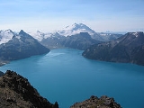
vents in the scenic Garibaldi Lake
area immediately north of Mount Garibaldi
was formed during the late Pleistocene
and early Holocene
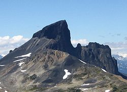
. The oldest stratovolcano, Black Tusk
, formed between about 1.3 and 1.1 million years ago (Ma). Following glacial dissection, renewed volcanism produced the lava dome
and flow forming its summit. Other Pleistocene vents are located along and to the west of the Cheakamus River
. Cinder Cone
, to the east of Black Tusk, produced a 9-km-long lava flow during the late Pleistocene or early Holocene.
 Mount Price, west of Garibaldi Lake, 5 km south of Black Tusk, was formed in three stages of activity, dating back 1.1 million years, the latest of which produced two large lava flow
s from Clinker Peak
during the early Holocene that ponded against the retreating continental ice sheet
and formed The Barrier
, containing Garibaldi Lake.
The Table
is a steep-sided andesite tuya
, situated approximately 3 km southwest of Mount Price and south of Garibaldi Lake. It rises 305 meters above glaciated
basement rock
s. The tuya formed by effusion of flatlying flows within erratics on its summit and lack of erosion
al features attributable to glacial suggest that The Table was also formed during the early Holocene
.
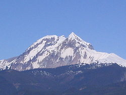
Mount Garibaldi
is the largest volcano in the Garibaldi Volcanic Belt
in southern British Columbia
, and is one of the few Cascade volcanoes
that is made exclusively of dacite
(Glacier Peak
is the other).
 Round Mountain
is an eroded volcanic outcrop, located 8 km southwest of Eanastick Meadows, 9 km east of Brackendale and 10 km south of Mount Garibaldi. It is the highpoint of Paul Ridge and last erupted during the Pleistocene.
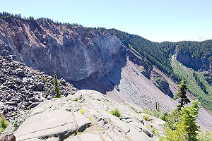
Opal Cone
is a cinder cone
on the southeast flank of Mount Garibaldi. It is the source of a 15 km long broad dacite lava flow with prominent wrinkled ridges. The lava flow is unusually long for a silicic lava flow.
Clinker Peak
is a stratovolcano on the west shoulder of Mount Price on the west side of Garibaldi Lake
. It has produced two large lava flows about 9,000 years ago.
Glacier Pikes
is a lava dome
with two rocky points at the southern end of the Sentinal Glacier Neve.
Mount Brew
is a subglacial mound
, which last erupted during the Pleistocene
.
 Future eruptions within the region could endanger the municipalities of Whistler
and Squamish
. Even though no Plinian eruption
s are recognized, even Peléan eruption
s may possibly create large amounts of volcanic ash
that will possibly affect these close by villages. Ash columns from the volcanoes might rise hundreds of metres and could make this a serious hazard for air traffic.
The unstable lava formation of The Barrier
has in the past unleashed several debris flow
s in the area below the lake, most recently in 1855-56 forming a large boulder field which gives Rubble Creek its name. Concerns about the Barrier's instability due to volcanic
, tectonic
, or heavy rainfall activity prompted the provincial government to declare the area immediately below it unsafe for human habitation in 1981. This led to the evacuation of the nearby village of Garibaldi
, and the relocation of residents to new recreational subdivisions away from the hazard zone. Should the Barrier completely collapse, Garibaldi Lake would be entirely released and downstream damage in the Cheakamus and Squamish River
s would be considerable, including major damage to the town of Squamish and possibly an impact wave on the waters of Howe Sound
that would reach Vancouver Island
.
Volcanic field
A volcanic field is an area of the Earth's crust that is prone to localized volcanic activity. They usually contain 10 to 100 volcanoes, such as cinder cones and are usually in clusters. Lava flows may also occur...
, located in British Columbia
British Columbia
British Columbia is the westernmost of Canada's provinces and is known for its natural beauty, as reflected in its Latin motto, Splendor sine occasu . Its name was chosen by Queen Victoria in 1858...
, Canada
Canada
Canada is a North American country consisting of ten provinces and three territories. Located in the northern part of the continent, it extends from the Atlantic Ocean in the east to the Pacific Ocean in the west, and northward into the Arctic Ocean...
. It was formed by a group of nine small andesitic stratovolcano
Stratovolcano
A stratovolcano, also known as a composite volcano, is a tall, conical volcano built up by many layers of hardened lava, tephra, pumice, and volcanic ash. Unlike shield volcanoes, stratovolcanoes are characterized by a steep profile and periodic, explosive eruptions...
es and basaltic andesite
Basaltic andesite
Basaltic andesite is a black volcanic rock containing about 55% silica. Minerals in basaltic andesite include olivine, augite and plagioclase. Basaltic andesite can be found in volcanoes around the world, including in Central America and the Andes of South America. Basaltic andesite is common in...
vents in the scenic Garibaldi Lake
Garibaldi Lake
The Garibaldi Lake volcanic field is a volcanic field, located in British Columbia, Canada. It was formed by a group of nine small andesitic stratovolcanoes and basaltic andesite vents in the scenic Garibaldi Lake area immediately north of Mount Garibaldi was formed during the late Pleistocene and...
area immediately north of Mount Garibaldi
Mount Garibaldi
Mount Garibaldi is a potentially active stratovolcano in the Sea to Sky Country of British Columbia, north of Vancouver, Canada. Located in the southernmost Coast Mountains, it is one of the most recognized peaks in the South Coast region, as well as British Columbia's best known volcano...
was formed during the late Pleistocene
Pleistocene
The Pleistocene is the epoch from 2,588,000 to 11,700 years BP that spans the world's recent period of repeated glaciations. The name pleistocene is derived from the Greek and ....
and early Holocene
Holocene
The Holocene is a geological epoch which began at the end of the Pleistocene and continues to the present. The Holocene is part of the Quaternary period. Its name comes from the Greek words and , meaning "entirely recent"...
. The oldest stratovolcano, Black Tusk
Black Tusk
Black Tusk is a remarkably abrupt pinnacle of volcanic rock located in Garibaldi Provincial Park of British Columbia, Canada. At above sea level, the upper spire is visible from a great distance in all directions. It is particularly noticeable from the Sea-to-Sky Highway just south of Whistler,...
, formed between about 1.3 and 1.1 million years ago (Ma). Following glacial dissection, renewed volcanism produced the lava dome
Lava dome
|250px|thumb|right|Image of the [[rhyolitic]] lava dome of [[Chaitén Volcano]] during its 2008–2009 eruption.In volcanology, a lava dome is a roughly circular mound-shaped protrusion resulting from the slow extrusion of viscous lava from a volcano...
and flow forming its summit. Other Pleistocene vents are located along and to the west of the Cheakamus River
Cheakamus River
The Cheakamus River is a tributary of the Squamish River, beginning on the west slopes of Outlier Peak in Garibaldi Provincial Park upstream from Cheakamus Lake on the southeastern outskirts of the resort area of Whistler. The river flows into Cheakamus Lake before exiting it and flowing...
. Cinder Cone
Cinder Cone (British Columbia)
Cinder Cone is a cinder cone with a small crater on the west side of the Helm Glacier in Garibaldi Provincial Park. Cinder Cone is surrounded by cinder flats and its crater is filled with melt water during the summer. Cinder Cone gets eroded easily by melt water during the spring, washing the...
, to the east of Black Tusk, produced a 9-km-long lava flow during the late Pleistocene or early Holocene.
Lava
Lava refers both to molten rock expelled by a volcano during an eruption and the resulting rock after solidification and cooling. This molten rock is formed in the interior of some planets, including Earth, and some of their satellites. When first erupted from a volcanic vent, lava is a liquid at...
s from Clinker Peak
Clinker Peak
Clinker Peak is a stratovolcano, in the Garibaldi Volcanic Belt, British Columbia, Canada. It is located on the west shoulder of Mount Price on the west side of Garibaldi Lake...
during the early Holocene that ponded against the retreating continental ice sheet
Ice sheet
An ice sheet is a mass of glacier ice that covers surrounding terrain and is greater than 50,000 km² , thus also known as continental glacier...
and formed The Barrier
The Barrier
The Barrier is a lava dam retaining the Garibaldi Lake system in southwestern British Columbia, Canada. It is over 300 m in thickness and about 2 km wide where it impounds the lake....
, containing Garibaldi Lake.
The Table
The Table
The Table, sometimes called Table Mountain, is a high flow-dominated andesite tuya located south of Garibaldi Lake, northeast of Cheekye and north of Mount Garibaldi, British Columbia, Canada...
is a steep-sided andesite tuya
Tuya
A tuya is a type of distinctive, flat-topped, steep-sided volcano formed when lava erupts through a thick glacier or ice sheet. They are somewhat rare worldwide, being confined to regions which were covered by glaciers and also had active volcanism during the same time period.-Formation:Tuyas are...
, situated approximately 3 km southwest of Mount Price and south of Garibaldi Lake. It rises 305 meters above glaciated
Glacier
A glacier is a large persistent body of ice that forms where the accumulation of snow exceeds its ablation over many years, often centuries. At least 0.1 km² in area and 50 m thick, but often much larger, a glacier slowly deforms and flows due to stresses induced by its weight...
basement rock
Rock (geology)
In geology, rock or stone is a naturally occurring solid aggregate of minerals and/or mineraloids.The Earth's outer solid layer, the lithosphere, is made of rock. In general rocks are of three types, namely, igneous, sedimentary, and metamorphic...
s. The tuya formed by effusion of flatlying flows within erratics on its summit and lack of erosion
Erosion
Erosion is when materials are removed from the surface and changed into something else. It only works by hydraulic actions and transport of solids in the natural environment, and leads to the deposition of these materials elsewhere...
al features attributable to glacial suggest that The Table was also formed during the early Holocene
Holocene
The Holocene is a geological epoch which began at the end of the Pleistocene and continues to the present. The Holocene is part of the Quaternary period. Its name comes from the Greek words and , meaning "entirely recent"...
.
Mount Garibaldi
Mount Garibaldi
Mount Garibaldi is a potentially active stratovolcano in the Sea to Sky Country of British Columbia, north of Vancouver, Canada. Located in the southernmost Coast Mountains, it is one of the most recognized peaks in the South Coast region, as well as British Columbia's best known volcano...
is the largest volcano in the Garibaldi Volcanic Belt
Garibaldi Volcanic Belt
The Garibaldi Volcanic Belt, also called the Canadian Cascade Arc, is a northwest-southeast trending volcanic chain in the Pacific Ranges of the Coast Mountains that extends from Watts Point in the south to the Ha-Iltzuk Icefield in the north. This chain of volcanoes is located in southwestern...
in southern British Columbia
British Columbia
British Columbia is the westernmost of Canada's provinces and is known for its natural beauty, as reflected in its Latin motto, Splendor sine occasu . Its name was chosen by Queen Victoria in 1858...
, and is one of the few Cascade volcanoes
Cascade Volcanoes
The Cascade Volcanoes are a number of volcanoes in a volcanic arc in western North America, extending from southwestern British Columbia through Washington and Oregon to Northern California, a distance of well over 700 mi ...
that is made exclusively of dacite
Dacite
Dacite is an igneous, volcanic rock. It has an aphanitic to porphyritic texture and is intermediate in composition between andesite and rhyolite. The relative proportions of feldspars and quartz in dacite, and in many other volcanic rocks, are illustrated in the QAPF diagram...
(Glacier Peak
Glacier Peak
Glacier Peak is the most isolated of the five major stratovolcanoes of the Cascade Volcanic Arc in Washington...
is the other).
Round Mountain (volcano)
Round Mountain is an eroded volcanic outcrop in the Garibaldi Volcanic Belt in British Columbia, Canada, located 8 km southwest of Eanastick Meadows, east of Brackendale and south of Mount Garibaldi. It is the highpoint of Paul Ridge and is located in the southwest corner of Garibaldi...
is an eroded volcanic outcrop, located 8 km southwest of Eanastick Meadows, 9 km east of Brackendale and 10 km south of Mount Garibaldi. It is the highpoint of Paul Ridge and last erupted during the Pleistocene.
Opal Cone
Opal Cone
Opal Cone is a cinder cone located on the southeast flank of Mount Garibaldi in the Coast Mountains of British Columbia, Canada. It is the source of a 15 km long broad dacite lava flow with prominent wrinkled ridges...
is a cinder cone
Cinder cone
According to the , Cinder Cone is the proper name of 1 cinder cone in Canada and 7 cinder cones in the United States:In Canada: Cinder Cone In the United States:...
on the southeast flank of Mount Garibaldi. It is the source of a 15 km long broad dacite lava flow with prominent wrinkled ridges. The lava flow is unusually long for a silicic lava flow.
Clinker Peak
Clinker Peak
Clinker Peak is a stratovolcano, in the Garibaldi Volcanic Belt, British Columbia, Canada. It is located on the west shoulder of Mount Price on the west side of Garibaldi Lake...
is a stratovolcano on the west shoulder of Mount Price on the west side of Garibaldi Lake
Garibaldi Lake
The Garibaldi Lake volcanic field is a volcanic field, located in British Columbia, Canada. It was formed by a group of nine small andesitic stratovolcanoes and basaltic andesite vents in the scenic Garibaldi Lake area immediately north of Mount Garibaldi was formed during the late Pleistocene and...
. It has produced two large lava flows about 9,000 years ago.
Glacier Pikes
Glacier Pikes
Glacier Pikes is a Lava dome, located in the Garibaldi Lake volcanic field, British Columbia, Canada. The dome has two rocky points at the southern end of the Sentinel Glacier Neve.-See also:*List of volcanoes in Canada*Volcanism of Canada...
is a lava dome
Lava dome
|250px|thumb|right|Image of the [[rhyolitic]] lava dome of [[Chaitén Volcano]] during its 2008–2009 eruption.In volcanology, a lava dome is a roughly circular mound-shaped protrusion resulting from the slow extrusion of viscous lava from a volcano...
with two rocky points at the southern end of the Sentinal Glacier Neve.
Mount Brew
Mount Brew (Cheakamus River)
Mount Brew is a rounded mountain in southwestern British Columbia, Canada, located southwest of Whistler in the Pacific Ranges of the Coast Mountains. A public cabin run by the Varsity Outdoor Club, Brew Hut, is located near the summit...
is a subglacial mound
Subglacial volcano
A subglacial volcano, also known as a glaciovolcano, is a volcanic form produced by subglacial eruptions or eruptions beneath the surface of a glacier or ice sheet which is then melted into a lake by the rising lava...
, which last erupted during the Pleistocene
Pleistocene
The Pleistocene is the epoch from 2,588,000 to 11,700 years BP that spans the world's recent period of repeated glaciations. The name pleistocene is derived from the Greek and ....
.
Hazards
Whistler, British Columbia
Whistler is a Canadian resort town in the southern Pacific Ranges of the Coast Mountains in the province of British Columbia, Canada, approximately north of Vancouver...
and Squamish
Squamish, British Columbia
Squamish is a community and a district municipality in the Canadian province of British Columbia, located at the north end of Howe Sound on the Sea to Sky Highway...
. Even though no Plinian eruption
Plinian eruption
Plinian eruptions, also known as 'Vesuvian eruptions', are volcanic eruptions marked by their similarity to the eruption of Mount Vesuvius in AD 79 ....
s are recognized, even Peléan eruption
Pelean eruption
Peléan eruptions are a type of volcanic eruption. They can occur when viscous magma, typically of rhyolitic or andesitic type, is involved, and share some similarities with Vulcanian eruptions. The most important characteristics of a Peléan eruption is the presence of a glowing avalanche of hot...
s may possibly create large amounts of volcanic ash
Volcanic ash
Volcanic ash consists of small tephra, which are bits of pulverized rock and glass created by volcanic eruptions, less than in diameter. There are three mechanisms of volcanic ash formation: gas release under decompression causing magmatic eruptions; thermal contraction from chilling on contact...
that will possibly affect these close by villages. Ash columns from the volcanoes might rise hundreds of metres and could make this a serious hazard for air traffic.
The unstable lava formation of The Barrier
The Barrier
The Barrier is a lava dam retaining the Garibaldi Lake system in southwestern British Columbia, Canada. It is over 300 m in thickness and about 2 km wide where it impounds the lake....
has in the past unleashed several debris flow
Debris flow
A debris flow is a fast moving, liquefied landslide of unconsolidated, saturated debris that looks like flowing concrete. It is differentiated from a mudflow in terms of the viscosity and textural properties of the flow. Flows can carry material ranging in size from clay to boulders, and may...
s in the area below the lake, most recently in 1855-56 forming a large boulder field which gives Rubble Creek its name. Concerns about the Barrier's instability due to volcanic
Volcano
2. Bedrock3. Conduit 4. Base5. Sill6. Dike7. Layers of ash emitted by the volcano8. Flank| 9. Layers of lava emitted by the volcano10. Throat11. Parasitic cone12. Lava flow13. Vent14. Crater15...
, tectonic
Plate tectonics
Plate tectonics is a scientific theory that describes the large scale motions of Earth's lithosphere...
, or heavy rainfall activity prompted the provincial government to declare the area immediately below it unsafe for human habitation in 1981. This led to the evacuation of the nearby village of Garibaldi
Garibaldi, British Columbia
Garibaldi, originally named Daisy Lake and also known as Garibaldi Lodge and Garibaldi Townsite, is an abandoned locality in British Columbia, Canada, on the Cheakamus River around its confluence with Rubble Creek and just south of Daisy Lake....
, and the relocation of residents to new recreational subdivisions away from the hazard zone. Should the Barrier completely collapse, Garibaldi Lake would be entirely released and downstream damage in the Cheakamus and Squamish River
Squamish River
The Squamish River is a short but very large river in the Canadian province of British Columbia. Its drainage basin is in size. The total length of the Squamish River is approximately .-Course:...
s would be considerable, including major damage to the town of Squamish and possibly an impact wave on the waters of Howe Sound
Howe Sound
Howe Sound is a roughly triangular sound, actually a network of fjords situated immediately northwest of Vancouver.-Geography:Howe Sound's mouth at the Strait of Georgia is situated between West Vancouver and the Sunshine Coast. The sound is triangular shaped, open on its southeast towards the...
that would reach Vancouver Island
Vancouver Island
Vancouver Island is a large island in British Columbia, Canada. It is one of several North American locations named after George Vancouver, the British Royal Navy officer who explored the Pacific Northwest coast of North America between 1791 and 1794...
.
See also
- List of volcanoes in Canada
- Cascade Volcanic ArcCascade VolcanoesThe Cascade Volcanoes are a number of volcanoes in a volcanic arc in western North America, extending from southwestern British Columbia through Washington and Oregon to Northern California, a distance of well over 700 mi ...
- Garibaldi Volcanic BeltGaribaldi Volcanic BeltThe Garibaldi Volcanic Belt, also called the Canadian Cascade Arc, is a northwest-southeast trending volcanic chain in the Pacific Ranges of the Coast Mountains that extends from Watts Point in the south to the Ha-Iltzuk Icefield in the north. This chain of volcanoes is located in southwestern...
- Garibaldi LakeGaribaldi LakeThe Garibaldi Lake volcanic field is a volcanic field, located in British Columbia, Canada. It was formed by a group of nine small andesitic stratovolcanoes and basaltic andesite vents in the scenic Garibaldi Lake area immediately north of Mount Garibaldi was formed during the late Pleistocene and...