

Tuya
Encyclopedia

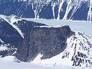
A tuya is a type of distinctive, flat-topped, steep-sided volcano
Volcano
2. Bedrock3. Conduit 4. Base5. Sill6. Dike7. Layers of ash emitted by the volcano8. Flank| 9. Layers of lava emitted by the volcano10. Throat11. Parasitic cone12. Lava flow13. Vent14. Crater15...
formed when lava
Lava
Lava refers both to molten rock expelled by a volcano during an eruption and the resulting rock after solidification and cooling. This molten rock is formed in the interior of some planets, including Earth, and some of their satellites. When first erupted from a volcanic vent, lava is a liquid at...
erupts through a thick glacier
Glacier
A glacier is a large persistent body of ice that forms where the accumulation of snow exceeds its ablation over many years, often centuries. At least 0.1 km² in area and 50 m thick, but often much larger, a glacier slowly deforms and flows due to stresses induced by its weight...
or ice sheet
Ice sheet
An ice sheet is a mass of glacier ice that covers surrounding terrain and is greater than 50,000 km² , thus also known as continental glacier...
. They are somewhat rare worldwide, being confined to regions which were covered by glacier
Glacier
A glacier is a large persistent body of ice that forms where the accumulation of snow exceeds its ablation over many years, often centuries. At least 0.1 km² in area and 50 m thick, but often much larger, a glacier slowly deforms and flows due to stresses induced by its weight...
s and also had active volcanism during the same time period.
Formation
Subglacial volcano
A subglacial volcano, also known as a glaciovolcano, is a volcanic form produced by subglacial eruptions or eruptions beneath the surface of a glacier or ice sheet which is then melted into a lake by the rising lava...
that consists of nearly horizontal beds of basaltic lava capping outward-dipping beds of fragmental volcanic rocks, and they often rise in isolation above a surrounding plateau
Plateau
In geology and earth science, a plateau , also called a high plain or tableland, is an area of highland, usually consisting of relatively flat terrain. A highly eroded plateau is called a dissected plateau...
. Tuyas are found throughout Iceland
Iceland
Iceland , described as the Republic of Iceland, is a Nordic and European island country in the North Atlantic Ocean, on the Mid-Atlantic Ridge. Iceland also refers to the main island of the country, which contains almost all the population and almost all the land area. The country has a population...
, British Columbia
British Columbia
British Columbia is the westernmost of Canada's provinces and is known for its natural beauty, as reflected in its Latin motto, Splendor sine occasu . Its name was chosen by Queen Victoria in 1858...
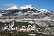
, the Santiam Pass
Santiam Pass
Santiam Pass is a mountain pass in the Cascade Range in central Oregon in the United States. It is located on the border between Linn and Jefferson counties, about northwest of Sisters, between the prominent volcanic horns of Three Fingered Jack to the north and Mount Washington to the south...
region in Oregon
Oregon
Oregon is a state in the Pacific Northwest region of the United States. It is located on the Pacific coast, with Washington to the north, California to the south, Nevada on the southeast and Idaho to the east. The Columbia and Snake rivers delineate much of Oregon's northern and eastern...
, the Antarctic Peninsula
Antarctic Peninsula
The Antarctic Peninsula is the northernmost part of the mainland of Antarctica. It extends from a line between Cape Adams and a point on the mainland south of Eklund Islands....
and beneath the West Antarctic Ice Sheet
West Antarctic Ice Sheet
The West Antarctic Ice Sheet is the segment of the continental ice sheet that covers West Antarctica, the portion of Antarctica on the side of the Transantarctic Mountains which lies in the Western Hemisphere. The WAIS is classified as a marine-based ice sheet, meaning that its bed lies well...
in Antarctica. Tuyas in Iceland
Iceland
Iceland , described as the Republic of Iceland, is a Nordic and European island country in the North Atlantic Ocean, on the Mid-Atlantic Ridge. Iceland also refers to the main island of the country, which contains almost all the population and almost all the land area. The country has a population...
are sometimes called table mountain
Table Mountain (disambiguation)
A table mountain is a large table or mesa hence the name of numerous mountains around the world:Mountains:*Table Mountain is a large flat-topped mountain overlooking Cape Town, South Africa....
s because of their flat tops.
S. Holland, a geographer
Geographer
A geographer is a scholar whose area of study is geography, the study of Earth's natural environment and human society.Although geographers are historically known as people who make maps, map making is actually the field of study of cartography, a subset of geography...
for the British Columbia government, described tuyas in the following way:
- "They have a most interesting origin ... [they were] formed by volcanic eruptions which had been thawed through the PleistocenePleistoceneThe Pleistocene is the epoch from 2,588,000 to 11,700 years BP that spans the world's recent period of repeated glaciations. The name pleistocene is derived from the Greek and ....
ice-sheet by underlying volcanic heat. The lavaLavaLava refers both to molten rock expelled by a volcano during an eruption and the resulting rock after solidification and cooling. This molten rock is formed in the interior of some planets, including Earth, and some of their satellites. When first erupted from a volcanic vent, lava is a liquid at...
s capping the mountainMountainImage:Himalaya_annotated.jpg|thumb|right|The Himalayan mountain range with Mount Everestrect 58 14 160 49 Chomo Lonzorect 200 28 335 52 Makalurect 378 24 566 45 Mount Everestrect 188 581 920 656 Tibetan Plateaurect 250 406 340 427 Rong River...
s were extruded after the volcanoes were built above lake-level, and the outward-dipping beds were formed by the chilling of the lava when it reached the water's edge."
Word origin
The origin of the term comes from Tuya ButteTuya Butte
Tuya Butte is a tuya in the Tuya Range of north-central British Columbia, Canada. It is a bit less isolated from other ranges than neighbouring Mount Josephine...
, one of many tuyas in the area of the Tuya River
Tuya River
The Tuya River is a major tributary of the Stikine River in far northwestern British Columbia, Canada. Rising at Tuya Lake, which is on the south side of Tuya Mountains Provincial Park, it flows south to meet the Stikine River where that river bisects the Tahltan Highland. Its main tributary is...
and Tuya Range
Tuya Range
The Tuya Range is a range of tuyas, located in the Stikine Ranges of the Cassiar Mountains in the far northr of the Canadian province of British Columbia, near its border with the Yukon Territory and to the southwest of Watson Lake, Yukon, which is the nearest major settlement.-Boundaries and...
in far northern British Columbia
British Columbia
British Columbia is the westernmost of Canada's provinces and is known for its natural beauty, as reflected in its Latin motto, Splendor sine occasu . Its name was chosen by Queen Victoria in 1858...
, Canada
Canada
Canada is a North American country consisting of ten provinces and three territories. Located in the northern part of the continent, it extends from the Atlantic Ocean in the east to the Pacific Ocean in the west, and northward into the Arctic Ocean...
.
While still in graduate school in 1947, Canadian geologist
Geologist
A geologist is a scientist who studies the solid and liquid matter that constitutes the Earth as well as the processes and history that has shaped it. Geologists usually engage in studying geology. Geologists, studying more of an applied science than a theoretical one, must approach Geology using...
Bill Mathews
Bill Mathews
William Henry Mathews was a Canadian geologist, volcanologist, engineer, and professor. He is considered a pioneer in the study of subglacial eruptions and volcano-ice interactions in North America...
published a paper titled, "Tuyas, Flat-Topped Volcanoes in Northern British Columbia", in which he coined the term "tuya" to refer to these distinctive volcanic formations. Tuya Butte is a near-ideal specimen of the type, the first such landform analyzed in the geological literature, and this name has since become standard worldwide among volcanologists in referring to and writing about these formations. The Tuya Mountains Provincial Park
Tuya Mountains Provincial Park
Tuya Mountains Provincial Park is a provincial park in British Columbia, Canada, protecting the Tuya Range, a volcanic region at the head of the Tuya River. The park is located on the north side of Tuya Lake. The park is named for nearby Tuyas, steep-sided, flat-topped types of volcano....
was recently established to protect this unusual landscape, which lies north of Tuya Lake
Tuya Lake
Tuya Lake, located in northwestern British Columbia, Canada, presumably derives its name from the presence of nearby steep-sided, flat-topped volcanoes, known as tuyas...
and south of the Jennings River
Jennings River
The Jennings River is a river in far northern British Columbia, Canada, rising in the northern reaches of the Stikine Ranges of the Cassiar Mountains, at first running southwest, then turning northeast near the Tuya Range to enter Teslin Lake at its southern end, just to the east of the estuary of...
near the boundary with the Yukon Territory. Around the same time that Mathews published his paper, the Icelandic geologist Guðmundur Kjartansson had distinguished between "móberg" ridges and tuyas in Iceland and proposed the hypothesis that they were formed during subglacial and intraglacial eruptions.
The term tuya may be derived from a Tahltan
Tahltan
Tahltan refers to a Northern Athabaskan people who live in northern British Columbia around Telegraph Creek, Dease Lake, and Iskut.-Social Organization:...
word.
A volcanic mesa near Santa Fe, New Mexico
Santa Fe, New Mexico
Santa Fe is the capital of the U.S. state of New Mexico. It is the fourth-largest city in the state and is the seat of . Santa Fe had a population of 67,947 in the 2010 census...
, known in English as Black Mesa and resembling a tuya, is known in Tewa
Tewa language
Tewa is a Kiowa–Tanoan language spoken by Pueblo people, mostly in the Rio Grande valley in New Mexico north of Santa Fe. The 1980 census counted 1,298 speakers, almost all of whom are bilingual in English...
as Tu-yohttp://books.google.com/books?id=wDsSAAAAYAAJ&pg=PA161&dq=black+mesa&client=firefox-a#PPA82,M1.
Examples
Antarctica
|
Canada:
|
United States:
|
Iceland:
|