

The Barrier
Encyclopedia
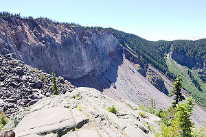
The Barrier is a lava dam
Volcanic dam
A volcanic dam is a type of natural dam produced directly or indirectly by volcanism, which holds or temporarily restricts the flow of surface water in existing streams, like a man-made dam. There are two main types of volcanic dams, those created by the flow of molten lava, and those created by...
retaining the Garibaldi Lake
Garibaldi Lake
The Garibaldi Lake volcanic field is a volcanic field, located in British Columbia, Canada. It was formed by a group of nine small andesitic stratovolcanoes and basaltic andesite vents in the scenic Garibaldi Lake area immediately north of Mount Garibaldi was formed during the late Pleistocene and...
system in southwestern British Columbia
British Columbia
British Columbia is the westernmost of Canada's provinces and is known for its natural beauty, as reflected in its Latin motto, Splendor sine occasu . Its name was chosen by Queen Victoria in 1858...
, Canada
Canada
Canada is a North American country consisting of ten provinces and three territories. Located in the northern part of the continent, it extends from the Atlantic Ocean in the east to the Pacific Ocean in the west, and northward into the Arctic Ocean...
. It is over 300 m (1,000 ft) in thickness and about 2 km (1.2 mi) wide where it impounds the lake.
The area below and adjacent to The Barrier is considered hazardous due to the unstable lava formation.
Formation
The Barrier was formed when large lava flows emanated from a vent on the west shoulder of Mount Price about 9,000 years ago called Clinker PeakClinker Peak
Clinker Peak is a stratovolcano, in the Garibaldi Volcanic Belt, British Columbia, Canada. It is located on the west shoulder of Mount Price on the west side of Garibaldi Lake...
. The large lava flowed towards the Cheakamus River
Cheakamus River
The Cheakamus River is a tributary of the Squamish River, beginning on the west slopes of Outlier Peak in Garibaldi Provincial Park upstream from Cheakamus Lake on the southeastern outskirts of the resort area of Whistler. The river flows into Cheakamus Lake before exiting it and flowing...
valley. At the time of eruption, the valley was filled by glacial ice. The lava flow was stopped by the ice and ponded, eventually cooling to form an ice-marginal lava flow. When the ice melted away, the ice-cooled lava-flow front formed a precipitous cliff; water ponded behind the lava dam, forming Garibaldi Lake.
Rubble Creek boulder field
The unstable lava formation of The Barrier has in the past unleashed several debris flowDebris flow
A debris flow is a fast moving, liquefied landslide of unconsolidated, saturated debris that looks like flowing concrete. It is differentiated from a mudflow in terms of the viscosity and textural properties of the flow. Flows can carry material ranging in size from clay to boulders, and may...
s in the area below Garibaldi Lake, most recently in 1855-1856 forming a large boulder field which gives Rubble Creek
Rubble Creek
Rubble Creek is a creek in southwestern British Columbia, Canada. It flows northwest into Cheakamus Creek near Mount Garibaldi....
its name. At least 30000000 cubic metre of rock was removed from The Barrier during the 1855-1856 event.
Hazards
Concerns about The Barrier's instability due to volcanic, tectonic, or heavy rainfall activity prompted the provincial governmentGovernment
Government refers to the legislators, administrators, and arbitrators in the administrative bureaucracy who control a state at a given time, and to the system of government by which they are organized...
to declare the area immediately below it unsafe for human habitation in 1981. This led to the evacuation of the small resort village of Garibaldi
Garibaldi, British Columbia
Garibaldi, originally named Daisy Lake and also known as Garibaldi Lodge and Garibaldi Townsite, is an abandoned locality in British Columbia, Canada, on the Cheakamus River around its confluence with Rubble Creek and just south of Daisy Lake....
nearby, and the relocation of residents to new recreational subdivisions away from the hazard zone. Should the Barrier completely collapse, Garibaldi Lake
Garibaldi Lake
The Garibaldi Lake volcanic field is a volcanic field, located in British Columbia, Canada. It was formed by a group of nine small andesitic stratovolcanoes and basaltic andesite vents in the scenic Garibaldi Lake area immediately north of Mount Garibaldi was formed during the late Pleistocene and...
would be entirely released and downstream damage in the Cheakamus
Cheakamus River
The Cheakamus River is a tributary of the Squamish River, beginning on the west slopes of Outlier Peak in Garibaldi Provincial Park upstream from Cheakamus Lake on the southeastern outskirts of the resort area of Whistler. The river flows into Cheakamus Lake before exiting it and flowing...
and Squamish River
Squamish River
The Squamish River is a short but very large river in the Canadian province of British Columbia. Its drainage basin is in size. The total length of the Squamish River is approximately .-Course:...
s would be considerable, including major damage to the town of Squamish
Squamish, British Columbia
Squamish is a community and a district municipality in the Canadian province of British Columbia, located at the north end of Howe Sound on the Sea to Sky Highway...
and possibly an impact-wave on the water
Water
Water is a chemical substance with the chemical formula H2O. A water molecule contains one oxygen and two hydrogen atoms connected by covalent bonds. Water is a liquid at ambient conditions, but it often co-exists on Earth with its solid state, ice, and gaseous state . Water also exists in a...
s of Howe Sound
Howe Sound
Howe Sound is a roughly triangular sound, actually a network of fjords situated immediately northwest of Vancouver.-Geography:Howe Sound's mouth at the Strait of Georgia is situated between West Vancouver and the Sunshine Coast. The sound is triangular shaped, open on its southeast towards the...
that would reach Vancouver Island
Vancouver Island
Vancouver Island is a large island in British Columbia, Canada. It is one of several North American locations named after George Vancouver, the British Royal Navy officer who explored the Pacific Northwest coast of North America between 1791 and 1794...
.
See also
- Garibaldi Lake volcanic field
- Garibaldi Volcanic BeltGaribaldi Volcanic BeltThe Garibaldi Volcanic Belt, also called the Canadian Cascade Arc, is a northwest-southeast trending volcanic chain in the Pacific Ranges of the Coast Mountains that extends from Watts Point in the south to the Ha-Iltzuk Icefield in the north. This chain of volcanoes is located in southwestern...
- Cascade VolcanoesCascade VolcanoesThe Cascade Volcanoes are a number of volcanoes in a volcanic arc in western North America, extending from southwestern British Columbia through Washington and Oregon to Northern California, a distance of well over 700 mi ...
- Volcanism in CanadaVolcanism in CanadaVolcanism of Canada has produced lava flows, lava plateaus, lava domes, cinder cones, stratovolcanoes, shield volcanoes, submarine volcanoes, calderas, diatremes, and maars, along with examples of more less common volcanic forms such as tuyas and subglacial mounds...
- Garibaldi Provincial ParkGaribaldi Provincial ParkGaribaldi Provincial Park, also called Garibaldi Park, is a wilderness park located in British Columbia, Canada, about 70 kilometres north of Vancouver. The park is located to the east of the Sea to Sky Highway between Squamish and Whistler and covers an area of over 1,950 square kilometres...