
Gandhi Sagar dam
Encyclopedia
The Gandhi Sagar Dam is one of the four dam
s built on India
's Chambal River
. The dam is located in the Mandsaur
district of the state of Madhya Pradesh
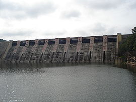
. It is a masonry gravity dam, standing 62.17 metres (204 ft) high, with a gross storage capacity of 7.322 billion cubic metres from a catchment area of 22584 km² (8,719.7 sq mi). The dam was completed in 1960, and sports a 115 MW hydroelectric power station at its toe, with five 23 MW generating units each providing a total energy generation of about 564 GWh. The water released after power generation is utilised for the irrigation of 427000 hectares (1,055,139 acre) by the Kota Barrage
, which is located 104 kilometres (64.6 mi) downstream of the dam, near the city of Kota
in the state of Rajasthan
.
Construction of the Gandhi Sagar Dam began when the foundation stone was laid by then-Prime Minister of India
Pandit Jawaharlal Nehru on 7 March 1954.
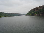
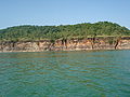
The reservoir area formed by the Gandhi Sagar Dam is the second largest in India (after the Hirakud Reservoir
), and attracts a large number of migratory and non-migratory birds throughout the year. The International Bird Life Agency (IBA) has qualified the reservoir under "A4iii" criteria, as the congregation of waterbirds is reported to exceed 20,000 at some points.
 The Chambal River (known in ancient times as the Chamranyavati River) raises in the Vindhya Range
at an elevation of 853m, 15 kilometres (9.3 mi) west-southwest of the town of Mhow, near Indore
. It flows north-northeast through Madhya Pradesh
, runs for a time through Rajasthan
, then forms the boundary between Rajasthan and Madhya Pradesh before turning southeast to join the Yamuna River in the state of Uttar Pradesh
. Its total length from its source to its confluence
with the Yamuna River is 900 kilometres (559.2 mi).
The Chambal and its tributaries drain the Malwa region of northwestern Madhya Pradesh, while its tributary, the Banas
, which rises in the Aravalli Range
, drains southeastern Rajasthan
. At its confluence with the Yamuna, the Chambal joins four other rivers - the Yamuna, Kwari, Sind
, and Pahuj
- at Pachnada
near Bhareh
in Uttar Pradesh, at the border of the Bhind
and Etawah
districts. The river is drained by a rain-fed catchment area with an average annual rainfall of 860 millimetres (33.9 in), a temperature range of between 2 °C (35.6 °F) and 40 °C (104 °F), and a relative humidity
ranging from 30% to 90%.
Between 344 kilometres (213.8 mi) and 440 kilometres (273.4 mi) from the Chambal's source is an area of deep gorges; the Gandhi Sagar Dam is located in the middle reach of this gorge section. The dam is situated at a distance of 168 kilometres (104.4 mi) from the district administrative headquarters of Mandsaur
.
 The Chambal River Valley Development
marked one of the landmark actions of the First Five-Year Plan
launched by the Government of India
in 1951, after India attained independence in August 1947
. The Chambal River had not until then been utilized for any major developmental works, and was proposed to be developed under a joint initiative of the state governments of Madhya Pradesh and Rajasthan. The three-stage proposal, drawn up in 1953, called for three dams to provide hydroelectric power generation, and a downstream barrage to utilize stored waters released from the upstream dams for irrigation
. The river's drop of 625 metres (2,050.5 ft) between its source in Mhow and the city of Kota, which marks the exit of the river from its gorge section into the plains of Rajasthan, was seen as having great hydroelectric potential.
 The first stage of the development involved construction of the Gandhi Sagar Dam to a height of a 62.17 metres (204 ft) as a storage dam to store 7,322,000,000 cubic metres in Madhya Pradesh and utilise the stored water for hydroelectric power generation, followed by irrigation from the Kota Barrage in Rajasthan, 104 km downstream of the dam. Power generation at Gandhi Sagar Dam was through a powerhouse at the toe of the dam with a total installed capacity of 115 MW (divided into five units of 23 MW). The Kota Barrage, an earth and masonry structure 37.34 metres (122.5 ft) in height, was built to provide irrigation through a canal system, with two main canals on the right and left banks.. Construction of both projects began in 1953–54; both began functioning in 1960. The water received at the Kota Barrage is shared equally between Madhya Pradesh and Rajasthan for irrigation.
, located 48 km downstream of the Gandhi Sagar at Rawatbhata
in the Chittorgarh District
of Rajasthan. Additional storage at this dam provides an increase in irrigation benefits from the Kota Barrage, increasing its area of irrigation from 445000 hectares (1,099,618 acre) to 567000 hectares (1,401,086.3 acre). In addition, a powerhouse at the toe of the dam provides an additional hydroelectric power generation capacity of 172 MW from four turbo generators, of 43 MW capacity each.
The second stage was completed in 1970. The power generated at the Rana Pratap Sagar Dam is shared equally with Madhya Pradesh, as the Gandhi Sagar Dam provides the stored waters for utilization at this dam.
. This dam is a concrete gravity dam, 45 metres (147.6 ft) high, located approximately 23 kilometres (14.3 mi) upstream of Kota Barrage to its southwest, and provides a hydroelectric power generation capacity of 99 MW, with three generator units of 33 MW capacity each. This project was commissioned in 1972.
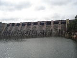
 Gandhi Sagar Dam is a masonry gravity dam with a height of 62.17 metres (204 ft) and a length of 514 metres (1,686.4 ft). The reservoir has a gross storage capacity of 7.32 billion cubic metres, with a live storage of 6.79 billion cubic metres corresponding to Full Reservoir Level (FRL) at 400 metres (1,312.3 ft). The spillway of the dam is designed for a discharge of 21,238 cubic metres per second. There are 10 gated spillway spans to pass the designed flood discharge. In addition, 9 river sluices have also been provided, but these have not been functional.
The hydroelectric power station is located at the toe of the dam on the right bank. The total flow through the five turbines is 311.15 m3/s. The power station has an installation of 142 MW with five turbines of 23 MW and one unit of 27 MW capacity. The power station is 65 metres (213.3 ft) long and 56 feet (17.1 m) wide. Power is supplied first to the local district and then to other regions of Madhya Pradesh and Rajasthan.
The Gandhi Sagar Dam and Power Station were built at a cost of about Rs. 2.3 billion.
(after the Hirakud Reservoir
). The catchment area of the Chambal River from the Vindhyachal
ranges to the south and Aravalli to the northeast, covering a drainage area of 22584 km² (8,719.7 sq mi); important tributaries that discharge into the Chambal upstream of this reservoir include the Shipra, Chhoti, Kalisindh, Ansar, and Rupniya on the eastern side, and the Tilsoi, Edar, Retum and Shivna in the west. The maximum length and width of the reservoir are 68 kilometres (42.3 mi) and 26 kilometres (16.2 mi), respectively. The Gandhi Sagar Wild Life Sanctuary, which has an area of 36700 hectares (90,687.6 acre), is shared by the Mandsaur and Neemuch district
s, in the catchment area of the Gandhi Sagar reservoir. The sanctuary's forested area was once a hunting area of the Holkar
royal family of Indore
. The reservoir is under the control of the irrigation and fisheries departments of the Government of Madhya Pradesh
, and is mostly used for fisheries development also.
The mean depth of the reservoir is 11.73 metres (38.5 ft), with a shore development index of 4.78, and a volume development index of 0.601 at the Full Reservoir Level. Scientific studies indicate that the reservoir is productive as regards fisheries, with the reservoir water indicating a moderate-to-high rate of primary productivity. Commercial Fisheries was initiated in 1959–60 in Gandhi Sagar, and has been credited as the best-managed reservoir in the state. Fish capture in the reservoir is prohibited between 16 June and 15 August.
The reservoir attracts a large number of migratory and non-migratory birds throughout the year, has been qualified under "A4iii criteria" by the IBA, as the bird congregation is of more than 20,000 waterbirds.
Dam
A dam is a barrier that impounds water or underground streams. Dams generally serve the primary purpose of retaining water, while other structures such as floodgates or levees are used to manage or prevent water flow into specific land regions. Hydropower and pumped-storage hydroelectricity are...
s built on India
India
India , officially the Republic of India , is a country in South Asia. It is the seventh-largest country by geographical area, the second-most populous country with over 1.2 billion people, and the most populous democracy in the world...
's Chambal River
Chambal River
The Chambal River is a tributary of the Yamuna River in central India, and forms part of the greater Gangetic drainage system. The river flows north-northeast through Madhya Pradesh, running for a time through Rajasthan, then forming the boundary between Rajasthan and Madhya Pradesh before turning...
. The dam is located in the Mandsaur
Mandsaur
Mandsaur or Mandsour is a city in the Malwa region and district of Madhya Pradesh state of central India. It is the administrative headquarters of Mandsaur District.-Origin of name:...
district of the state of Madhya Pradesh
Madhya Pradesh
Madhya Pradesh , often called the Heart of India, is a state in central India. Its capital is Bhopal and Indore is the largest city....
. It is a masonry gravity dam, standing 62.17 metres (204 ft) high, with a gross storage capacity of 7.322 billion cubic metres from a catchment area of 22584 km² (8,719.7 sq mi). The dam was completed in 1960, and sports a 115 MW hydroelectric power station at its toe, with five 23 MW generating units each providing a total energy generation of about 564 GWh. The water released after power generation is utilised for the irrigation of 427000 hectares (1,055,139 acre) by the Kota Barrage
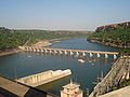
Kota Barrage
Kota Barrage is the fourth in the series of Chambal Valley Projects, located about 0.8 km upstream of Kota City in Rajasthan. Water released after power generation at Gandhi Sagar dam, Rana Pratap Sagar dam and Jawahar Sagar Dams, is diverted by Kota Barrage for irrigation in Rajasthan and in...
, which is located 104 kilometres (64.6 mi) downstream of the dam, near the city of Kota
Kota, Rajasthan
Kota , formerly known as Kotah, is a city in the northern Indian state of Rajasthan. It is located south of state capital, Jaipur. Situated on the banks of Chambal River, the city is the trade centre for an area in which millet, wheat, rice, pulses, coriander and oilseeds are grown; industries...
in the state of Rajasthan
Rajasthan
Rājasthān the land of Rajasthanis, , is the largest state of the Republic of India by area. It is located in the northwest of India. It encompasses most of the area of the large, inhospitable Great Indian Desert , which has an edge paralleling the Sutlej-Indus river valley along its border with...
.
Construction of the Gandhi Sagar Dam began when the foundation stone was laid by then-Prime Minister of India
Prime Minister of India
The Prime Minister of India , as addressed to in the Constitution of India — Prime Minister for the Union, is the chief of government, head of the Council of Ministers and the leader of the majority party in parliament...
Pandit Jawaharlal Nehru on 7 March 1954.
The reservoir area formed by the Gandhi Sagar Dam is the second largest in India (after the Hirakud Reservoir
Hirakud Dam
Hirakud Dam is built across the Mahanadi River, about 15 km from Sambalpur in the state of Orissa in India. Built in 1957, the dam is one of the world's longest earthen dam....
), and attracts a large number of migratory and non-migratory birds throughout the year. The International Bird Life Agency (IBA) has qualified the reservoir under "A4iii" criteria, as the congregation of waterbirds is reported to exceed 20,000 at some points.
Geography
Vindhya Range
The Vindhya Range is a range of older rounded mountains and hills in the west-central Indian subcontinent, which geographically separates the Indian subcontinent into northern India and Southern India.- Introduction :...
at an elevation of 853m, 15 kilometres (9.3 mi) west-southwest of the town of Mhow, near Indore
Indore
Indore is one of the major city in India, the largest city and commercial center of the state of Madhya Pradesh in central India. Indore is located 190 km west of the state capital Bhopal. According to the 2011 Indian census, Indore city has a population of 1,960,631...
. It flows north-northeast through Madhya Pradesh
Madhya Pradesh
Madhya Pradesh , often called the Heart of India, is a state in central India. Its capital is Bhopal and Indore is the largest city....
, runs for a time through Rajasthan
Rajasthan
Rājasthān the land of Rajasthanis, , is the largest state of the Republic of India by area. It is located in the northwest of India. It encompasses most of the area of the large, inhospitable Great Indian Desert , which has an edge paralleling the Sutlej-Indus river valley along its border with...
, then forms the boundary between Rajasthan and Madhya Pradesh before turning southeast to join the Yamuna River in the state of Uttar Pradesh
Uttar Pradesh
Uttar Pradesh abbreviation U.P. , is a state located in the northern part of India. With a population of over 200 million people, it is India's most populous state, as well as the world's most populous sub-national entity...
. Its total length from its source to its confluence
Confluence
Confluence, in geography, describes the meeting of two or more bodies of water.Confluence may also refer to:* Confluence , a property of term rewriting systems...
with the Yamuna River is 900 kilometres (559.2 mi).
The Chambal and its tributaries drain the Malwa region of northwestern Madhya Pradesh, while its tributary, the Banas
Banas River
The Banas is a river of Rajasthan state in western India. It is a tributary of the Chambal River, which in turn flows into the Yamuna, a tributary of the Ganges. The Banas is approximately 512 kilometres in length. It is also known as 'Van Ki Asha' .The Banas originates in the Khamnor Hills of the...
, which rises in the Aravalli Range
Aravalli Range
The Aravalli Range literally meaning 'line of peaks', is a range of mountains in western India and eastern Pakistan running approximately 800 km from northeast to southwest across states of Rajasthan, Haryana, and Gujarat and Pakistani provinces of Punjab and Sindh...
, drains southeastern Rajasthan
Rajasthan
Rājasthān the land of Rajasthanis, , is the largest state of the Republic of India by area. It is located in the northwest of India. It encompasses most of the area of the large, inhospitable Great Indian Desert , which has an edge paralleling the Sutlej-Indus river valley along its border with...
. At its confluence with the Yamuna, the Chambal joins four other rivers - the Yamuna, Kwari, Sind
Sindh River
The Sindh River, a tributary of the Yamuna River, flows through the Indian states of Madhya Pradesh and Uttar Pradesh.-Course:The Sindh originates on the Malwa Plateau in Vidisha district, and flows north-northeast through the districts of Guna, Ashoknagar, Shivpuri, Datia, Gwalior and Bhind in...
, and Pahuj
Pahuj River
Pahuj River is a river flowing in Bhind District of Madhya Pradesh in central India.It is tributary of Sindh River, which joins Yamuna River in Etawah Uttar Pradesh state, just after the Chambal River confluences into Yamuna river....
- at Pachnada
Pachnada
The Pachnada is an area, near Bhareh in Uttar Pradesh state, at the border of Bhind and Etawah districts, where the tourists can witness the confluence of five rivers, Kunwari, Pahuj, Jamuna), Chambal and Sind....
near Bhareh
Bhareh
Bhareh is a town in Eatwah district in the state of Uttar Pradesh, India....
in Uttar Pradesh, at the border of the Bhind
Bhind District
Bhind District is a district of Madhya Pradesh state in central India of Chambal region. The town of Bhind is the district headquarter....
and Etawah
Etawah District
Etawah district is a district in the southwestern portion of Uttar Pradesh state of India. Etawah town is the district headquarters. Etawah district is part of Kanpur Division. The district covers an area of 2311 km²...
districts. The river is drained by a rain-fed catchment area with an average annual rainfall of 860 millimetres (33.9 in), a temperature range of between 2 °C (35.6 °F) and 40 °C (104 °F), and a relative humidity
Humidity
Humidity is a term for the amount of water vapor in the air, and can refer to any one of several measurements of humidity. Formally, humid air is not "moist air" but a mixture of water vapor and other constituents of air, and humidity is defined in terms of the water content of this mixture,...
ranging from 30% to 90%.
Between 344 kilometres (213.8 mi) and 440 kilometres (273.4 mi) from the Chambal's source is an area of deep gorges; the Gandhi Sagar Dam is located in the middle reach of this gorge section. The dam is situated at a distance of 168 kilometres (104.4 mi) from the district administrative headquarters of Mandsaur
Mandsaur
Mandsaur or Mandsour is a city in the Malwa region and district of Madhya Pradesh state of central India. It is the administrative headquarters of Mandsaur District.-Origin of name:...
.
Development history
Chambal River
The Chambal River is a tributary of the Yamuna River in central India, and forms part of the greater Gangetic drainage system. The river flows north-northeast through Madhya Pradesh, running for a time through Rajasthan, then forming the boundary between Rajasthan and Madhya Pradesh before turning...
marked one of the landmark actions of the First Five-Year Plan
Five-Year Plans of India
The economy of India is based in part on planning through its five-year plans, which are developed, executed and monitored by the Planning Commission. The tenth plan completed its term in March 2007 and the eleventh plan is currently underway...
launched by the Government of India
Government of India
The Government of India, officially known as the Union Government, and also known as the Central Government, was established by the Constitution of India, and is the governing authority of the union of 28 states and seven union territories, collectively called the Republic of India...
in 1951, after India attained independence in August 1947
History of the Republic of India
The history of the Republic of India began on 26 January 1950. The country became an independent dominion within the British Commonwealth 15 August 1947. George VI was King until the Republic was proclaimed in 1950. Concurrently the Muslim-majority northwest and east of British India was separated...
. The Chambal River had not until then been utilized for any major developmental works, and was proposed to be developed under a joint initiative of the state governments of Madhya Pradesh and Rajasthan. The three-stage proposal, drawn up in 1953, called for three dams to provide hydroelectric power generation, and a downstream barrage to utilize stored waters released from the upstream dams for irrigation
Irrigation
Irrigation may be defined as the science of artificial application of water to the land or soil. It is used to assist in the growing of agricultural crops, maintenance of landscapes, and revegetation of disturbed soils in dry areas and during periods of inadequate rainfall...
. The river's drop of 625 metres (2,050.5 ft) between its source in Mhow and the city of Kota, which marks the exit of the river from its gorge section into the plains of Rajasthan, was seen as having great hydroelectric potential.
Stage I
Stage II
The second stage of development involved the utilization of the water released from the Gandhi Sagar Dam through another dam structure, the Rana Pratap Sagar DamRana Pratap Sagar dam
The Rana Pratap Sagar Dam is a gravity masonry dam of height built on the Chambal River at Rawatbhata in Rajasthan in India. It is part of integrated scheme of a cascade development of the river involving four projects starting with the Gandhi Sagar Dam in the upstream reach in Madhya Pradesh and...
, located 48 km downstream of the Gandhi Sagar at Rawatbhata
Rawatbhata
Rawatbhata is a town and a municipality in Chittorgarh district in the Indian state of Rajasthan. It is 50 km from the nearest city Kota. Rawatbhata is connected to the major routes in country through Kota .-Geography:...
in the Chittorgarh District
Chittorgarh district
Chittorgarh District is a district of Rajasthan state in western India. The historic city of Chittorgarh is the administrative headquarters of the district....
of Rajasthan. Additional storage at this dam provides an increase in irrigation benefits from the Kota Barrage, increasing its area of irrigation from 445000 hectares (1,099,618 acre) to 567000 hectares (1,401,086.3 acre). In addition, a powerhouse at the toe of the dam provides an additional hydroelectric power generation capacity of 172 MW from four turbo generators, of 43 MW capacity each.
The second stage was completed in 1970. The power generated at the Rana Pratap Sagar Dam is shared equally with Madhya Pradesh, as the Gandhi Sagar Dam provides the stored waters for utilization at this dam.
Stage III
The third and final stage of development envisaged an intermediate dam between the Rana Pratap Sagar Dam and the Kota Barrage, called the Jawahar Sagar DamJawahar Sagar Dam
Jawahar Sagar Dam is a dam across the Chambal River. It is situated 24 kilometres south-west of Kota, Rajasthan, India.-References:*...
. This dam is a concrete gravity dam, 45 metres (147.6 ft) high, located approximately 23 kilometres (14.3 mi) upstream of Kota Barrage to its southwest, and provides a hydroelectric power generation capacity of 99 MW, with three generator units of 33 MW capacity each. This project was commissioned in 1972.
Features
The hydroelectric power station is located at the toe of the dam on the right bank. The total flow through the five turbines is 311.15 m3/s. The power station has an installation of 142 MW with five turbines of 23 MW and one unit of 27 MW capacity. The power station is 65 metres (213.3 ft) long and 56 feet (17.1 m) wide. Power is supplied first to the local district and then to other regions of Madhya Pradesh and Rajasthan.
The Gandhi Sagar Dam and Power Station were built at a cost of about Rs. 2.3 billion.
Reservoir
The reservoir area of 723 km² (279.2 sq mi) created by the dam is the second largest in IndiaIndia
India , officially the Republic of India , is a country in South Asia. It is the seventh-largest country by geographical area, the second-most populous country with over 1.2 billion people, and the most populous democracy in the world...
(after the Hirakud Reservoir
Hirakud Dam
Hirakud Dam is built across the Mahanadi River, about 15 km from Sambalpur in the state of Orissa in India. Built in 1957, the dam is one of the world's longest earthen dam....
). The catchment area of the Chambal River from the Vindhyachal
Vindhyachal
Vindhyachal is a town in Mirzapur District of Uttar Pradesh state in northern India. The city is a Hindu pilgrimage site having the temple of Vindhyavasini, where according to mythology a part of Sati Born in Nand Yadav Family as sister of Lord Krishna. The river Ganges flows through this city...
ranges to the south and Aravalli to the northeast, covering a drainage area of 22584 km² (8,719.7 sq mi); important tributaries that discharge into the Chambal upstream of this reservoir include the Shipra, Chhoti, Kalisindh, Ansar, and Rupniya on the eastern side, and the Tilsoi, Edar, Retum and Shivna in the west. The maximum length and width of the reservoir are 68 kilometres (42.3 mi) and 26 kilometres (16.2 mi), respectively. The Gandhi Sagar Wild Life Sanctuary, which has an area of 36700 hectares (90,687.6 acre), is shared by the Mandsaur and Neemuch district
Neemuch District
Neemuch district is one of the 50 districts of Madhya Pradesh state in central India. The town of Neemuch is the administrative headquarters of the district.Neemuch district is part of Ujjain Division and had approximately 700,000 inhabitants as of 2001...
s, in the catchment area of the Gandhi Sagar reservoir. The sanctuary's forested area was once a hunting area of the Holkar
Holkar
The Holkar dynasty , whose earliest known clan-man was Malhar Rao, who joined the service of the Peshwa in 1721, and quickly rose to the ranks of Subedar...
royal family of Indore
Indore
Indore is one of the major city in India, the largest city and commercial center of the state of Madhya Pradesh in central India. Indore is located 190 km west of the state capital Bhopal. According to the 2011 Indian census, Indore city has a population of 1,960,631...
. The reservoir is under the control of the irrigation and fisheries departments of the Government of Madhya Pradesh
Government of Madhya Pradesh
The Government of Madhya Pradesh also known as the State Government of Madhya Pradesh, or locally as State Government, is the supreme governing authority of the Indian state of Madhya Pradesh and its 50 districts...
, and is mostly used for fisheries development also.
The mean depth of the reservoir is 11.73 metres (38.5 ft), with a shore development index of 4.78, and a volume development index of 0.601 at the Full Reservoir Level. Scientific studies indicate that the reservoir is productive as regards fisheries, with the reservoir water indicating a moderate-to-high rate of primary productivity. Commercial Fisheries was initiated in 1959–60 in Gandhi Sagar, and has been credited as the best-managed reservoir in the state. Fish capture in the reservoir is prohibited between 16 June and 15 August.
The reservoir attracts a large number of migratory and non-migratory birds throughout the year, has been qualified under "A4iii criteria" by the IBA, as the bird congregation is of more than 20,000 waterbirds.