
Shenandoah Highway
Encyclopedia
State Highway 65 is a New Zealand
State Highway
in the South Island
. It is 71 km long and runs south to north down the Maruia river valley from SH 7 at Springs Junction, 15 km west of the main divide at the Lewis Pass, to SH 6 in the Buller Gorge, 11 km west of Murchison
. It forms part of the most direct route between Christchurch
and Nelson
. It takes its name from a small settlement toward its northern end.
The road is sealed and two-lane, with some single-lane bridges. The surrounding country is used for pastoral farming (beef and dairy) with some forestry on the surrounding hills.
Springs Junction is the only locality with fuel or food along the route while Maruia
is the largest settlement along the route.
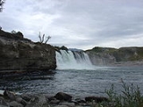
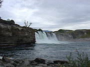 Maruia Falls, a 5-m waterfall near the road, did not exist prior to the 1929 Murchison earthquake
(magnitude
7.8).
New Zealand
New Zealand is an island country in the south-western Pacific Ocean comprising two main landmasses and numerous smaller islands. The country is situated some east of Australia across the Tasman Sea, and roughly south of the Pacific island nations of New Caledonia, Fiji, and Tonga...
State Highway
New Zealand State Highway network
The New Zealand State Highway network is the major national highway network in New Zealand. Just under 100 roads in both the North and South Islands are State Highways...
in the South Island
South Island
The South Island is the larger of the two major islands of New Zealand, the other being the more populous North Island. It is bordered to the north by Cook Strait, to the west by the Tasman Sea, to the south and east by the Pacific Ocean...
. It is 71 km long and runs south to north down the Maruia river valley from SH 7 at Springs Junction, 15 km west of the main divide at the Lewis Pass, to SH 6 in the Buller Gorge, 11 km west of Murchison
Murchison, New Zealand
Murchison is a town in the Tasman Region of the South Island of New Zealand. It is near the western end of the "Four Rivers Plain", at the confluence of the Buller River and the Matakitaki River...
. It forms part of the most direct route between Christchurch
Christchurch
Christchurch is the largest city in the South Island of New Zealand, and the country's second-largest urban area after Auckland. It lies one third of the way down the South Island's east coast, just north of Banks Peninsula which itself, since 2006, lies within the formal limits of...
and Nelson
Nelson, New Zealand
Nelson is a city on the eastern shores of Tasman Bay, and is the economic and cultural centre of the Nelson-Tasman region. Established in 1841, it is the second oldest settled city in New Zealand and the oldest in the South Island....
. It takes its name from a small settlement toward its northern end.
The road is sealed and two-lane, with some single-lane bridges. The surrounding country is used for pastoral farming (beef and dairy) with some forestry on the surrounding hills.
Springs Junction is the only locality with fuel or food along the route while Maruia
Maruia
Maruia is a locality in the West Coast region of New Zealand. The Shenandoah Highway passes through it. Murchison is 65 km north, the Lewis Pass is 39 km to the south-east, and Reefton is 63 km west by road...
is the largest settlement along the route.
1929 Murchison earthquake
The 1929 Murchison earthquake occurred at 10:17 AM on 17 June. It struck the Murchison region of South Island, with an estimated magnitude of 7.8, and was felt throughout New Zealand. There were 17 casualties, mostly as a result of landslides triggered by the earthquake...
(magnitude
Surface wave magnitude
The surface wave magnitude scale is one of the magnitude scales used in seismology to describe the size of an earthquake. It is based on measurements in Rayleigh surface waves that travel primarily along the uppermost layers of the earth...
7.8).