

Ethiopia-United States Mapping Mission
Encyclopedia
The Ethiopia-United States Mapping Mission, also known as the Ethi-U.S. Mapping Mission, was an operation undertaken by the United States Army
during the 1960s to provide up-to-date topographic map
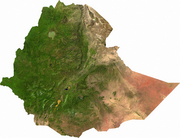
coverage of the entire country of Ethiopia
. The soldiers who conducted the mapping operations on the ground during that time used the latest surveying and mapping techniques and were exposed to many hardships and dangers, but they completed their mission near the end of the decade. The maps that were created still serve as the base maps for the country of Ethiopia and are presently being updated and maintained by the Ethiopian Mapping Authority
.
, later U.S. Army Topographic Command (TOPOCOM), Special Foreign Activity during the Cold War
in the 1960s to survey and map the entire country of Ethiopia, then under the rule of Emperor Haile Selassie I
. Aviation support was primarily provided by the 572nd Engineer Platoon (Topographic Aviation) and civilian pilots under contract, along with some early support from the U.S. Air Force and Ethiopian Airlines
. Battalion Headquarters was located in Leghorn (Livorno
), Italy
, and the Mapping Mission itself was headquartered in Addis Ababa
, the nation's centrally located capital.
region of Africa
. They also struggled to subsist in remote areas of the country that included jungles, deserts, dense bush, mountains and swamps that harbored deadly snakes, crocodiles, lions, leopards, hyenas, hippos, cape buffalo, elephants, wild dogs, dangerous bees and ants, aggressive tribes of baboons and sometimes hostile natives, not to mention any number of malignant diseases. In addition, these troops and their support personnel were frequently required to conduct their operations in active war zones along the Somalia
and Sudan
borders, where brutal wars and indiscriminate killing had been going on for years, and the area of the country that is now Eritrea
, where the Eritrean Liberation Front
was engaged in armed struggle with imperial Ethiopian forces.
used by the Ethiopia-United States Mapping Mission was flown by the U.S. Air Force, normally at an altitude above 30,000 feet for optimum coverage. The geographic coordinates (latitude and longitude
) of the location of the aircraft (and therefore the aerial photo camera station) with respect to known stations on the ground was controlled horizontally by a system known as HIRAN (High Range Navigation Radar), a large and heavy system that required a large aircraft, such as the RB-50
. High-quality horizontal geodetic
control was established by the topographic surveyors on the bulky HIRAN ground stations by measuring their cardinal direction distances from nearby photo-identifiable points on which the surveyors established horizontal positions using theodolites
and electronic distance meters (EDM)
and triangulation
and traverse
techniques.
A device known as a Terrain Profile Recorder (TPR), which used the boiling point of a liquid chemical at a specific altitude and a gyroscopically stabilized radar altimeter was used to determine and maintain the altitude of the aircraft above a known elevation, such as a large body of water, while taking a series of aerial photographs that overlapped in the direction of flight and across flight lines in order to provide stereoscopic
photo coverage of the entire area. Strategically located photo-identifiable points were selected in areas of overlap between photo flight lines and elevations were established on these points by the topographic surveyors using differential levelling
techniques.
Geographic coordinates and elevations (representing all three dimensions) were later extended by Army Map Service personnel to other strategically located points on the photos using computers and analytical methods of photogrammetric
modeling. These computer-generated photo control points were then used to compile, or draw, the planimetric map to the desired scale and delineate its contours from stereo models of the photos using special stereoscopic mapping equipment. Once the map images were drawn in detail to uniform scale and made into detailed map reproducibles through photographic processes, printing plates were produced and maps were printed in volume on an offset printing press
, a fast and efficient process that is still in use today.
Gravimeter
s, small portable units that provide measurements of the force of gravity, were also used by the surveyors to conduct gravity surveys to further understand the topography
of the country and the geodetic datum.
Field classification specialists, soldiers as well as civilians from Army Map Service, were utilized to conduct research on the ground in order to provide names of cities and towns and any other prominent named features, as well as classify types of roads, buildings, hydrographic features such as lakes and rivers, and any other features to be depicted on the maps. Interpreters were used to interview local officials and residents to determine proper names, spelling and usage of features.
 The Ethiopia-U.S. Mapping Mission was activated in July 1963 and during its lifespan involved about a thousand U.S. military and civilian personnel . It was closed out in July 1970 after its topographic surveying mission in Ethiopia was complete. Photogrammetric
and cartographic
map finishing operations based on these surveys were subsequently completed by Army Map Service/TOPOCOM in Bethesda
, Maryland
. The primary 1:250,000-scale map series and 1:50,000-scale maps of special interest areas that were created as a result of this operation still serve as the base maps for the country of Ethiopia, and are presently being maintained and updated by the Ethiopian Mapping Authority in Addis Ababa.
United States Army
The United States Army is the main branch of the United States Armed Forces responsible for land-based military operations. It is the largest and oldest established branch of the U.S. military, and is one of seven U.S. uniformed services...
during the 1960s to provide up-to-date topographic map
Topographic map
A topographic map is a type of map characterized by large-scale detail and quantitative representation of relief, usually using contour lines in modern mapping, but historically using a variety of methods. Traditional definitions require a topographic map to show both natural and man-made features...
coverage of the entire country of Ethiopia
Ethiopia
Ethiopia , officially known as the Federal Democratic Republic of Ethiopia, is a country located in the Horn of Africa. It is the second-most populous nation in Africa, with over 82 million inhabitants, and the tenth-largest by area, occupying 1,100,000 km2...
. The soldiers who conducted the mapping operations on the ground during that time used the latest surveying and mapping techniques and were exposed to many hardships and dangers, but they completed their mission near the end of the decade. The maps that were created still serve as the base maps for the country of Ethiopia and are presently being updated and maintained by the Ethiopian Mapping Authority
Ethiopian Mapping Authority
The Ethiopian Mapping Authority is a branch of the Ethiopian government, a department within the Ministry of Interior, that is responsible for cartographic mapping and remote sensing activities in Ethiopia...
.
The Mission
The Ethiopia-United States Mapping Mission was a mission of the U.S. Army, 64th Engineer Battalion, 29th Engineer Company and U.S. Army Map ServiceNational Geospatial-Intelligence Agency
The National Geospatial-Intelligence Agency is an agency of the federal government of the United States with the primary mission of collecting, analyzing and distributing geospatial intelligence in support of national security. NGA was formerly known as the National Imagery and Mapping Agency ...
, later U.S. Army Topographic Command (TOPOCOM), Special Foreign Activity during the Cold War
Cold War
The Cold War was the continuing state from roughly 1946 to 1991 of political conflict, military tension, proxy wars, and economic competition between the Communist World—primarily the Soviet Union and its satellite states and allies—and the powers of the Western world, primarily the United States...
in the 1960s to survey and map the entire country of Ethiopia, then under the rule of Emperor Haile Selassie I
Haile Selassie I of Ethiopia
Haile Selassie I , born Tafari Makonnen, was Ethiopia's regent from 1916 to 1930 and Emperor of Ethiopia from 1930 to 1974...
. Aviation support was primarily provided by the 572nd Engineer Platoon (Topographic Aviation) and civilian pilots under contract, along with some early support from the U.S. Air Force and Ethiopian Airlines
Ethiopian Airlines
Ethiopian Airlines , formerly Ethiopian Air Lines, often referred to as simply Ethiopian, is an airline headquartered on the grounds of Bole International Airport in Addis Ababa, Ethiopia. It serves as the country's flag carrier, and is wholly owned by the Government of Ethiopia...
. Battalion Headquarters was located in Leghorn (Livorno
Livorno
Livorno , traditionally Leghorn , is a port city on the Tyrrhenian Sea on the western edge of Tuscany, Italy. It is the capital of the Province of Livorno, having a population of approximately 160,000 residents in 2009.- History :...
), Italy
Italy
Italy , officially the Italian Republic languages]] under the European Charter for Regional or Minority Languages. In each of these, Italy's official name is as follows:;;;;;;;;), is a unitary parliamentary republic in South-Central Europe. To the north it borders France, Switzerland, Austria and...
, and the Mapping Mission itself was headquartered in Addis Ababa
Addis Ababa
Addis Ababa is the capital city of Ethiopia...
, the nation's centrally located capital.
The Men
The topographic surveyors and their aviation support pilots and crew served on field parties that endured sweltering heat in this Sub SaharanSub-Saharan Africa
Sub-Saharan Africa as a geographical term refers to the area of the African continent which lies south of the Sahara. A political definition of Sub-Saharan Africa, instead, covers all African countries which are fully or partially located south of the Sahara...
region of Africa
Africa
Africa is the world's second largest and second most populous continent, after Asia. At about 30.2 million km² including adjacent islands, it covers 6% of the Earth's total surface area and 20.4% of the total land area...
. They also struggled to subsist in remote areas of the country that included jungles, deserts, dense bush, mountains and swamps that harbored deadly snakes, crocodiles, lions, leopards, hyenas, hippos, cape buffalo, elephants, wild dogs, dangerous bees and ants, aggressive tribes of baboons and sometimes hostile natives, not to mention any number of malignant diseases. In addition, these troops and their support personnel were frequently required to conduct their operations in active war zones along the Somalia
Ethiopian-Somali conflict
The Ethiopian–Somali conflict and tension has a historical background in territorial and political disputes. Animosity between Ethiopians and Somalis dates back a millenia with wars and conflicts . In recent years, those tensions caused two wars.- Historical background :A broader perspective shows...
and Sudan
First Sudanese Civil War
The First Sudanese Civil War was a conflict from 1955 to 1972 between the northern part of Sudan and the southern Sudan region that demanded representation and more regional autonomy...
borders, where brutal wars and indiscriminate killing had been going on for years, and the area of the country that is now Eritrea
Eritrea
Eritrea , officially the State of Eritrea, is a country in the Horn of Africa. Eritrea derives it's name from the Greek word Erethria, meaning 'red land'. The capital is Asmara. It is bordered by Sudan in the west, Ethiopia in the south, and Djibouti in the southeast...
, where the Eritrean Liberation Front
Eritrean Liberation Front
The Eritrean Liberation Front was the main independence movement in Eritrea which sought Eritrea's independence from Ethiopia during the 1960s and 1970s. In the very late 1950s unorganized political movement seeking independence was secretly active as small cells...
was engaged in armed struggle with imperial Ethiopian forces.
The Methods
The aerial photographyAerial photography
Aerial photography is the taking of photographs of the ground from an elevated position. The term usually refers to images in which the camera is not supported by a ground-based structure. Cameras may be hand held or mounted, and photographs may be taken by a photographer, triggered remotely or...
used by the Ethiopia-United States Mapping Mission was flown by the U.S. Air Force, normally at an altitude above 30,000 feet for optimum coverage. The geographic coordinates (latitude and longitude
Geographic coordinate system
A geographic coordinate system is a coordinate system that enables every location on the Earth to be specified by a set of numbers. The coordinates are often chosen such that one of the numbers represent vertical position, and two or three of the numbers represent horizontal position...
) of the location of the aircraft (and therefore the aerial photo camera station) with respect to known stations on the ground was controlled horizontally by a system known as HIRAN (High Range Navigation Radar), a large and heavy system that required a large aircraft, such as the RB-50
B-50 Superfortress
The Boeing B-50 Superfortress strategic bomber was a post-World War II revision of the Boeing B-29 Superfortress, fitted with more powerful Pratt & Whitney R-4360 radial engines, stronger structure, a taller fin, and other improvements. It was the last piston-engined bomber designed by Boeing for...
. High-quality horizontal geodetic
Geodesy
Geodesy , also named geodetics, a branch of earth sciences, is the scientific discipline that deals with the measurement and representation of the Earth, including its gravitational field, in a three-dimensional time-varying space. Geodesists also study geodynamical phenomena such as crustal...
control was established by the topographic surveyors on the bulky HIRAN ground stations by measuring their cardinal direction distances from nearby photo-identifiable points on which the surveyors established horizontal positions using theodolites
Theodolite
A theodolite is a precision instrument for measuring angles in the horizontal and vertical planes. Theodolites are mainly used for surveying applications, and have been adapted for specialized purposes in fields like metrology and rocket launch technology...
and electronic distance meters (EDM)
Surveying
See Also: Public Land Survey SystemSurveying or land surveying is the technique, profession, and science of accurately determining the terrestrial or three-dimensional position of points and the distances and angles between them...
and triangulation
Triangulation
In trigonometry and geometry, triangulation is the process of determining the location of a point by measuring angles to it from known points at either end of a fixed baseline, rather than measuring distances to the point directly...
and traverse
Traverse (surveying)
Traverse is a method in the field of surveying to establish control networks. It is also used in geodesy. Traverse networks involve placing survey stations along a line or path of travel, and then using the previously surveyed points as a base for observing the next point...
techniques.
A device known as a Terrain Profile Recorder (TPR), which used the boiling point of a liquid chemical at a specific altitude and a gyroscopically stabilized radar altimeter was used to determine and maintain the altitude of the aircraft above a known elevation, such as a large body of water, while taking a series of aerial photographs that overlapped in the direction of flight and across flight lines in order to provide stereoscopic
Stereoscopy
Stereoscopy refers to a technique for creating or enhancing the illusion of depth in an image by presenting two offset images separately to the left and right eye of the viewer. Both of these 2-D offset images are then combined in the brain to give the perception of 3-D depth...
photo coverage of the entire area. Strategically located photo-identifiable points were selected in areas of overlap between photo flight lines and elevations were established on these points by the topographic surveyors using differential levelling
Surveying
See Also: Public Land Survey SystemSurveying or land surveying is the technique, profession, and science of accurately determining the terrestrial or three-dimensional position of points and the distances and angles between them...
techniques.
Geographic coordinates and elevations (representing all three dimensions) were later extended by Army Map Service personnel to other strategically located points on the photos using computers and analytical methods of photogrammetric
Photogrammetry
Photogrammetry is the practice of determining the geometric properties of objects from photographic images. Photogrammetry is as old as modern photography and can be dated to the mid-nineteenth century....
modeling. These computer-generated photo control points were then used to compile, or draw, the planimetric map to the desired scale and delineate its contours from stereo models of the photos using special stereoscopic mapping equipment. Once the map images were drawn in detail to uniform scale and made into detailed map reproducibles through photographic processes, printing plates were produced and maps were printed in volume on an offset printing press
Offset printing
Offset printing is a commonly used printing technique in which the inked image is transferred from a plate to a rubber blanket, then to the printing surface...
, a fast and efficient process that is still in use today.
Gravimeter
Gravimeter
A gravimeter or gravitometer is an instrument used in gravimetry for measuring the local gravitational field of the Earth. A gravimeter is a type of accelerometer, specialized for measuring the constant downward acceleration of gravity, which varies by about 0.5% over the surface of the Earth...
s, small portable units that provide measurements of the force of gravity, were also used by the surveyors to conduct gravity surveys to further understand the topography
Topography
Topography is the study of Earth's surface shape and features or those ofplanets, moons, and asteroids...
of the country and the geodetic datum.
Field classification specialists, soldiers as well as civilians from Army Map Service, were utilized to conduct research on the ground in order to provide names of cities and towns and any other prominent named features, as well as classify types of roads, buildings, hydrographic features such as lakes and rivers, and any other features to be depicted on the maps. Interpreters were used to interview local officials and residents to determine proper names, spelling and usage of features.
The Maps
Photogrammetry
Photogrammetry is the practice of determining the geometric properties of objects from photographic images. Photogrammetry is as old as modern photography and can be dated to the mid-nineteenth century....
and cartographic
Cartography
Cartography is the study and practice of making maps. Combining science, aesthetics, and technique, cartography builds on the premise that reality can be modeled in ways that communicate spatial information effectively.The fundamental problems of traditional cartography are to:*Set the map's...
map finishing operations based on these surveys were subsequently completed by Army Map Service/TOPOCOM in Bethesda
Bethesda, Maryland
Bethesda is a census designated place in southern Montgomery County, Maryland, United States, just northwest of Washington, D.C. It takes its name from a local church, the Bethesda Meeting House , which in turn took its name from Jerusalem's Pool of Bethesda...
, Maryland
Maryland
Maryland is a U.S. state located in the Mid Atlantic region of the United States, bordering Virginia, West Virginia, and the District of Columbia to its south and west; Pennsylvania to its north; and Delaware to its east...
. The primary 1:250,000-scale map series and 1:50,000-scale maps of special interest areas that were created as a result of this operation still serve as the base maps for the country of Ethiopia, and are presently being maintained and updated by the Ethiopian Mapping Authority in Addis Ababa.
External links
- Geoinfo - United Nations Economic Commission for Africa web site, Ethiopia, EMA
- ETHIOPIA: The Foreign Minister's Delusion web site
- Project King's Ransom Project web site
- ETHIOPIA TOPOGRAPHIC MAPS East View CartographicEast View CartographicEast View Cartographic is a leading American provider of geospatial information, and of cartographic and GIS services, much of it outsourced to offshore companies...
web site - Ethiopia-United States Mapping Mission
- Stars and Stripes Article refers to U.S. Cold War mapping of Ethiopia
- Buying Maps from EMA