

Ethiopian Mapping Authority
Encyclopedia
Remote sensing
Remote sensing is the acquisition of information about an object or phenomenon, without making physical contact with the object. In modern usage, the term generally refers to the use of aerial sensor technologies to detect and classify objects on Earth by means of propagated signals Remote sensing...
activities in Ethiopia
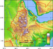
Ethiopia
Ethiopia , officially known as the Federal Democratic Republic of Ethiopia, is a country located in the Horn of Africa. It is the second-most populous nation in Africa, with over 82 million inhabitants, and the tenth-largest by area, occupying 1,100,000 km2...
. During its early years, the EMA benefited from United States
United States
The United States of America is a federal constitutional republic comprising fifty states and a federal district...
assistance, both in terms of financial assistance from the Point Four Program
Point Four Program
The Point Four Program was a technical assistance program for "developing countries" announced by United States President Harry S. Truman in his inaugural address on January 20, 1949...
and a comprehensive base mapping operation of the country undertaken by the United States Army
United States Army
The United States Army is the main branch of the United States Armed Forces responsible for land-based military operations. It is the largest and oldest established branch of the U.S. military, and is one of seven U.S. uniformed services...
. Today the EMA has expanded its operation to include a comprehensive map revision program in addition to various phases of digital mapping
Digital mapping
Digital mapping is the process by which a collection of data is compiled and formatted into a virtual image. The primary function of this technology is to produce maps that give accurate representations of a particular area, detailing major road arteries and other points of interest...
and information technology
Information technology
Information technology is the acquisition, processing, storage and dissemination of vocal, pictorial, textual and numerical information by a microelectronics-based combination of computing and telecommunications...
.
Origin
The Ethiopian Mapping Authority, originally known as the Ethiopian Mapping and Geography Institute, located in Addis AbabaAddis Ababa
Addis Ababa is the capital city of Ethiopia...
, Ethiopia, is the official organization responsible for mapping, surveying and remote sensing activities in Ethiopia
Ethiopia
Ethiopia , officially known as the Federal Democratic Republic of Ethiopia, is a country located in the Horn of Africa. It is the second-most populous nation in Africa, with over 82 million inhabitants, and the tenth-largest by area, occupying 1,100,000 km2...
. The organization was established in 1954 under the reign of Emperor Haile Selassie I as a department in the Imperial Ethiopian Ministry of Education
Education in Ethiopia
Education in Ethiopia has been dominated by the Ethiopian Orthodox Church for many centuries until secular education was adopted in the early 1900s. Prior to 1974, Ethiopia had an estimated illiteracy rate well above 90% and compared poorly with the rest of Africa in the provision of schools and...
. It was initially established to produce graphic materials and geography
Geography
Geography is the science that studies the lands, features, inhabitants, and phenomena of Earth. A literal translation would be "to describe or write about the Earth". The first person to use the word "geography" was Eratosthenes...
textbooks for educational purposes.
U.S. Assistance
The Institute was transferred to the Ministry of Interior in 1960 and expanded its operations to include some basic cartographic activities and extended research. The organization had benefited from the United States' Point Four Program of financial aid until it was discontinued in 1962, at which time the country entered into an agreement with the United States for the U.S. Army Map ServiceNational Geospatial-Intelligence Agency
The National Geospatial-Intelligence Agency is an agency of the federal government of the United States with the primary mission of collecting, analyzing and distributing geospatial intelligence in support of national security. NGA was formerly known as the National Imagery and Mapping Agency ...
, later known as Topographic Command (Topocom), to produce base maps of the country. The topographic surveying was provided by soldiers from the 64th Engineer Battalion, 29th Engineer Company, and the project was known as the Ethiopia-United States Mapping Mission
Ethiopia-United States Mapping Mission
The Ethiopia-United States Mapping Mission, also known as the Ethi-U.S. Mapping Mission, was an operation undertaken by the United States Army during the 1960s to provide up-to-date topographic map coverage of the entire country of Ethiopia...
. Using the survey data from the Mapping Mission, The Army Map Service/Topocom completed the photogrammetric map compilation and cartographic map finishing operations. The resulting 1:250,000-scale base maps of the country and 1:50,000-scale maps of special interest areas served as the impetus for the Institute to begin its cartographic map maintenance and distribution program. The organization was placed under a Director General with two Directors and seventy employees, and was reorganized into three subdivisions: Photogrammetry
Photogrammetry
Photogrammetry is the practice of determining the geometric properties of objects from photographic images. Photogrammetry is as old as modern photography and can be dated to the mid-nineteenth century....
, Cartography
Cartography
Cartography is the study and practice of making maps. Combining science, aesthetics, and technique, cartography builds on the premise that reality can be modeled in ways that communicate spatial information effectively.The fundamental problems of traditional cartography are to:*Set the map's...
and Photo Laboratory. The Institute was reorganized again in 1980 and was renamed the Ethiopian Mapping Authority.
The EMA Today
Today, the EMA employs about 350 people engaged in aerial photographyAerial photography
Aerial photography is the taking of photographs of the ground from an elevated position. The term usually refers to images in which the camera is not supported by a ground-based structure. Cameras may be hand held or mounted, and photographs may be taken by a photographer, triggered remotely or...
, geodetic surveying, photogrammetric, cartographic and photo lab activities to support and maintain its 1:250,000; 1:50,000; 1:1,000,000; 1:2,000,000; National Atlas
Atlas
An atlas is a collection of maps; it is typically a map of Earth or a region of Earth, but there are atlases of the other planets in the Solar System. Atlases have traditionally been bound into book form, but today many atlases are in multimedia formats...
of Ethiopia and 1:15,000-scale map of Addis Ababa. In addition, it is involved in remote sensing
Remote sensing
Remote sensing is the acquisition of information about an object or phenomenon, without making physical contact with the object. In modern usage, the term generally refers to the use of aerial sensor technologies to detect and classify objects on Earth by means of propagated signals Remote sensing...
, orthophoto
Orthophoto
An orthophoto, orthophotograph or orthoimage is an aerial photograph geometrically corrected such that the scale is uniform: the photo has the same lack of distortion as a map...
mapping, information technology
Information technology
Information technology is the acquisition, processing, storage and dissemination of vocal, pictorial, textual and numerical information by a microelectronics-based combination of computing and telecommunications...
, digital mapping
Digital mapping
Digital mapping is the process by which a collection of data is compiled and formatted into a virtual image. The primary function of this technology is to produce maps that give accurate representations of a particular area, detailing major road arteries and other points of interest...
and land use
Land use
Land use is the human use of land. Land use involves the management and modification of natural environment or wilderness into built environment such as fields, pastures, and settlements. It has also been defined as "the arrangements, activities and inputs people undertake in a certain land cover...
/land cover
Land Cover
Land cover is the physical material at the surface of the earth. Land covers include grass, asphalt, trees, bare ground, water, etc. There are two primary methods for capturing information on land cover: field survey and analysis of remotely sensed imagery....
(LULC) studies and maintains a library of geoinformation
Geoinformation
Geoinformation is an abbreviation of geographic information. Geographic information is created by manipulating geographic data in a computerized system. Systems can include computers and networks, standards and protocols for data use and exchange between users within a range of different...
in support of Ethiopia's infrastructure
Outline of Ethiopia
The Federal Democratic Republic of Ethiopia is a landlocked sovereign country located in the Horn of Africa. Ethiopia is bordered by Eritrea to the north, Sudan to the west, South Sudan to the south-west, Kenya to the south, Somalia to the east and Djibouti to the north-east.Ethiopia is one of the...
.
External links
- Portals to the World - Geography and Environment: Ethiopia
- Federal Democratic Republic of Ethiopia - EMA
- Ethiopia Topographic Maps East View CartographicEast View CartographicEast View Cartographic is a leading American provider of geospatial information, and of cartographic and GIS services, much of it outsourced to offshore companies...
web site - UNDP Emergencies Unit for Ethiopia - EMA Maps