
Erving, Massachusetts
Encyclopedia
Erving is a town
in Franklin County
, Massachusetts
, United States
. The population was 1,467 at the 2000 census. It is part of the Springfield, Massachusetts
metropolitan statistical area
.
, the area was part of the Pocomtuc
Indian Nation, whose villages nearby included Squawkeag in what is now Northfield
, and Peskeompscut in what is now Turners Falls
. Eventually, most of the native population was displaced and/or sold into slavery
as a result of King Philip's War
and a series of massacres of local Indian villages.
Subsequently, Erving was first settled in 1801 and officially incorporated in 1838. What is now Erving was once the farm
of John Erving, the first colonial in the area. Noted in the 19th-century for timber
and grazing
, the town had seven sawmill
s, two chair
factories, one pail, one children's carriage
, and one bit-brace factory. Large numbers of railroad tie
s and telegraph poles were cut in the abundant forests here, as many as 1,495,000 in one year.
Today, Erving has a school, a police and fire department, public library, several small stores and restaurants.
, the town has a total area of 14.4 square miles (37.3 km²), of which 13.9 square miles (36 km²) is land and 0.5 square miles (1.3 km²) (3.61%) is water. The Millers River
, a tributary of the Connecticut River
, passes through the town.
The terrain of Erving is hilly and rugged; most of the developed area of the town is located along the river. Northfield Mountain
and its peaks occupy much of the northern two-thirds of the town. The mountain is the location of a pumped storage hydroelectric facility
.
Erving is situated along Route 2, a heavily traveled state highway.
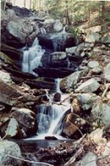
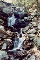 The town is home to a number of topographic features popular among outdoor recreation enthusiasts. The Millers River
is used for fishing and whitewater kayaking
. Northfield Mountain hosts cross country ski trails, hiking trails, and rock climbing ascents, including the 110 miles (177 km) Metacomet-Monadnock Trail
and the Farley Ledges
rock climbing area.
of 2000, there were 1,467 people, 600 households, and 400 families residing in the town. The population density
was 105.7 people per square mile (40.8/km²). There were 630 housing units at an average density of 45.4 per square mile (17.5/km²). The racial makeup of the town was 96.80% White, 0.14% African American, 0.82% Native American, 0.14% Asian, 0.41% from other races
, and 1.70% from two or more races. Hispanic or Latino of any race were 0.89% of the population.
There were 600 households out of which 29.2% had children under the age of 18 living with them, 53.3% were married couples
living together, 8.0% had a female householder with no husband present, and 33.3% were non-families. 26.7% of all households were made up of individuals and 12.2% had someone living alone who was 65 years of age or older. The average household size was 2.45 and the average family size was 2.94.
In the town the population was spread out with 22.9% under the age of 18, 6.5% from 18 to 24, 30.5% from 25 to 44, 26.3% from 45 to 64, and 13.8% who were 65 years of age or older. The median age was 39 years. For every 100 females there were 101.2 males. For every 100 females age 18 and over, there were 99.1 males.
The median income for a household in the town was $40,039, and the median income for a family was $47,212. Males had a median income of $35,511 versus $26,711 for females. The per capita income
for the town was $19,107. About 4.7% of families and 6.7% of the population were below the poverty line, including 8.5% of those under age 18 and 5.1% of those age 65 or over.
New England town
The New England town is the basic unit of local government in each of the six New England states. Without a direct counterpart in most other U.S. states, New England towns are conceptually similar to civil townships in other states, but are incorporated, possessing powers like cities in other...
in Franklin County
Franklin County, Massachusetts
-Demographics:As of the census of 2000, there were 71,535 people, 29,466 households, and 18,416 families residing in the county. The population density was 102 people per square mile . There were 31,939 housing units at an average density of 46 per square mile...
, Massachusetts
Massachusetts
The Commonwealth of Massachusetts is a state in the New England region of the northeastern United States of America. It is bordered by Rhode Island and Connecticut to the south, New York to the west, and Vermont and New Hampshire to the north; at its east lies the Atlantic Ocean. As of the 2010...
, United States
United States
The United States of America is a federal constitutional republic comprising fifty states and a federal district...
. The population was 1,467 at the 2000 census. It is part of the Springfield, Massachusetts
Springfield, Massachusetts
Springfield is the most populous city in Western New England, and the seat of Hampden County, Massachusetts, United States. Springfield sits on the eastern bank of the Connecticut River near its confluence with three rivers; the western Westfield River, the eastern Chicopee River, and the eastern...
metropolitan statistical area
Springfield, Massachusetts metropolitan area
The Springfield Metropolitan Area is a region that is socio-economically and culturally tied to the City of Springfield, Massachusetts. The U.S. Office of Management and Budget defines the Springfield metropolitan statistical area as consisting of three counties in Western Massachusetts. As of...
.
History
Located along the Mohawk TrailMohawk Trail
- External links :* *...
, the area was part of the Pocomtuc
Pocomtuc
The Pocumtuck, also Pocomtuc or Deerfield Indians, were a Native American tribe formerly inhabiting western Massachusetts, especially around the confluence of the Deerfield and Connecticut Rivers in Franklin County. Their territory also included parts of Hampden and Hampshire County, as well as...
Indian Nation, whose villages nearby included Squawkeag in what is now Northfield
Northfield, Massachusetts
Northfield is a town in Franklin County, Massachusetts, United States. The population was 2,951 at the 2000 census. It is part of the Springfield, Massachusetts Metropolitan Statistical Area...
, and Peskeompscut in what is now Turners Falls
Turners Falls, Massachusetts
Turners Falls is an unincorporated village and census-designated place in the town of Montague in Franklin County, Massachusetts, United States. The population was 4,441 at the 2000 census. It is part of the Springfield, Massachusetts Metropolitan Statistical Area...
. Eventually, most of the native population was displaced and/or sold into slavery
Slavery
Slavery is a system under which people are treated as property to be bought and sold, and are forced to work. Slaves can be held against their will from the time of their capture, purchase or birth, and deprived of the right to leave, to refuse to work, or to demand compensation...
as a result of King Philip's War
King Philip's War
King Philip's War, sometimes called Metacom's War, Metacomet's War, or Metacom's Rebellion, was an armed conflict between Native American inhabitants of present-day southern New England and English colonists and their Native American allies in 1675–76. The war is named after the main leader of the...
and a series of massacres of local Indian villages.
Subsequently, Erving was first settled in 1801 and officially incorporated in 1838. What is now Erving was once the farm
Farm
A farm is an area of land, or, for aquaculture, lake, river or sea, including various structures, devoted primarily to the practice of producing and managing food , fibres and, increasingly, fuel. It is the basic production facility in food production. Farms may be owned and operated by a single...
of John Erving, the first colonial in the area. Noted in the 19th-century for timber
Timber
Timber may refer to:* Timber, a term common in the United Kingdom and Australia for wood materials * Timber, Oregon, an unincorporated community in the U.S...
and grazing
Grazing
Grazing generally describes a type of feeding, in which a herbivore feeds on plants , and also on other multicellular autotrophs...
, the town had seven sawmill
Sawmill
A sawmill is a facility where logs are cut into boards.-Sawmill process:A sawmill's basic operation is much like those of hundreds of years ago; a log enters on one end and dimensional lumber exits on the other end....
s, two chair
Chair
A chair is a stable, raised surface used to sit on, commonly for use by one person. Chairs are most often supported by four legs and have a back; however, a chair can have three legs or could have a different shape depending on the criteria of the chair specifications. A chair without a back or...
factories, one pail, one children's carriage
Carriage
A carriage is a wheeled vehicle for people, usually horse-drawn; litters and sedan chairs are excluded, since they are wheelless vehicles. The carriage is especially designed for private passenger use and for comfort or elegance, though some are also used to transport goods. It may be light,...
, and one bit-brace factory. Large numbers of railroad tie
Railroad tie
A railroad tie/railway tie , or railway sleeper is a rectangular item used to support the rails in railroad tracks...
s and telegraph poles were cut in the abundant forests here, as many as 1,495,000 in one year.
Today, Erving has a school, a police and fire department, public library, several small stores and restaurants.
Geography
According to the United States Census BureauUnited States Census Bureau
The United States Census Bureau is the government agency that is responsible for the United States Census. It also gathers other national demographic and economic data...
, the town has a total area of 14.4 square miles (37.3 km²), of which 13.9 square miles (36 km²) is land and 0.5 square miles (1.3 km²) (3.61%) is water. The Millers River
Millers River
The Millers River is a river in northern Massachusetts, originating in Ashburnham and joining the Connecticut River just downstream from Millers Falls, Massachusetts...
, a tributary of the Connecticut River
Connecticut River
The Connecticut River is the largest and longest river in New England, and also an American Heritage River. It flows roughly south, starting from the Fourth Connecticut Lake in New Hampshire. After flowing through the remaining Connecticut Lakes and Lake Francis, it defines the border between the...
, passes through the town.
The terrain of Erving is hilly and rugged; most of the developed area of the town is located along the river. Northfield Mountain
Northfield Mountain
Northfield Mountain, , is a mountain ridge located in Erving and Northfield, Massachusetts. long by long, the mountain is composed of several distinct peaks and ledges, most notabily Rattlesnake Mountain , Rose Ledges , and Hermit Mountain...
and its peaks occupy much of the northern two-thirds of the town. The mountain is the location of a pumped storage hydroelectric facility
Pumped-storage hydroelectricity
Pumped-storage hydroelectricity is a type of hydroelectric power generation used by some power plants for load balancing. The method stores energy in the form of water, pumped from a lower elevation reservoir to a higher elevation. Low-cost off-peak electric power is used to run the pumps...
.
Erving is situated along Route 2, a heavily traveled state highway.
Outdoor recreation
Millers River
The Millers River is a river in northern Massachusetts, originating in Ashburnham and joining the Connecticut River just downstream from Millers Falls, Massachusetts...
is used for fishing and whitewater kayaking
Whitewater kayaking
Whitewater kayaking is the sport of paddling a kayak on a moving body of water, typically a whitewater river. Whitewater kayaking can range from simple, carefree gently moving water, to demanding, dangerous whitewater. River rapids are graded like ski runs according to the difficulty, danger or...
. Northfield Mountain hosts cross country ski trails, hiking trails, and rock climbing ascents, including the 110 miles (177 km) Metacomet-Monadnock Trail
Metacomet-Monadnock Trail
The Metacomet-Monadnock Trail is a hiking trail that traverses the Metacomet Ridge of the Pioneer Valley region of Massachusetts and the central uplands of Massachusetts and southern New Hampshire...
and the Farley Ledges
Farley Ledges
Farley Ledges, , also known as Rattlesnake Mountain, is a bluff knob located on the southeast side of Northfield Mountain in eastern Franklin County, Massachusetts. The ledge is notable for its extensive rock climbing ascents; it rises above the small village of Farley and has been used by rock...
rock climbing area.
Demographics
As of the censusCensus
A census is the procedure of systematically acquiring and recording information about the members of a given population. It is a regularly occurring and official count of a particular population. The term is used mostly in connection with national population and housing censuses; other common...
of 2000, there were 1,467 people, 600 households, and 400 families residing in the town. The population density
Population density
Population density is a measurement of population per unit area or unit volume. It is frequently applied to living organisms, and particularly to humans...
was 105.7 people per square mile (40.8/km²). There were 630 housing units at an average density of 45.4 per square mile (17.5/km²). The racial makeup of the town was 96.80% White, 0.14% African American, 0.82% Native American, 0.14% Asian, 0.41% from other races
Race (United States Census)
Race and ethnicity in the United States Census, as defined by the Federal Office of Management and Budget and the United States Census Bureau, are self-identification data items in which residents choose the race or races with which they most closely identify, and indicate whether or not they are...
, and 1.70% from two or more races. Hispanic or Latino of any race were 0.89% of the population.
There were 600 households out of which 29.2% had children under the age of 18 living with them, 53.3% were married couples
Marriage
Marriage is a social union or legal contract between people that creates kinship. It is an institution in which interpersonal relationships, usually intimate and sexual, are acknowledged in a variety of ways, depending on the culture or subculture in which it is found...
living together, 8.0% had a female householder with no husband present, and 33.3% were non-families. 26.7% of all households were made up of individuals and 12.2% had someone living alone who was 65 years of age or older. The average household size was 2.45 and the average family size was 2.94.
In the town the population was spread out with 22.9% under the age of 18, 6.5% from 18 to 24, 30.5% from 25 to 44, 26.3% from 45 to 64, and 13.8% who were 65 years of age or older. The median age was 39 years. For every 100 females there were 101.2 males. For every 100 females age 18 and over, there were 99.1 males.
The median income for a household in the town was $40,039, and the median income for a family was $47,212. Males had a median income of $35,511 versus $26,711 for females. The per capita income
Per capita income
Per capita income or income per person is a measure of mean income within an economic aggregate, such as a country or city. It is calculated by taking a measure of all sources of income in the aggregate and dividing it by the total population...
for the town was $19,107. About 4.7% of families and 6.7% of the population were below the poverty line, including 8.5% of those under age 18 and 5.1% of those age 65 or over.