
Farley Ledges
Encyclopedia
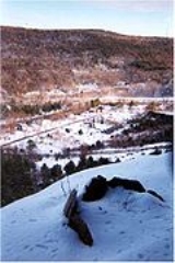
Farley Ledges, 1067 feet (325.2 m), also known as Rattlesnake Mountain, is a bluff knob located on the southeast side of Northfield Mountain
in eastern Franklin County, Massachusetts
. The ledge is notable for its extensive rock climbing
ascents; it rises 700 feet (213.4 m) above the small village of Farley (part of Erving, Massachusetts
) and has been used by rock climbers since the 1970s. The Western Massachusetts Climbers Coalition has been active in purchasing land to preserve access to the mountain; 2007 purchases include a parcel along Route 2
slated to be developed into a trailhead with a parking lot and access corridor to the ledges. The 110 miles (177 km) Metacomet-Monadnock Trail
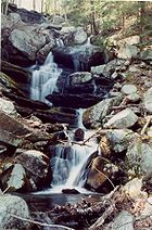
ascends the wooded north side of the ledges where Briggs Brook Falls tumbles from the ridgecrest; a marked rock climbing access loop trail departs from the Metacomet-Monadnock Trail to traverse both the summit of the ledges and the extensive boulder field beneath.
Northfield Mountain
Northfield Mountain, , is a mountain ridge located in Erving and Northfield, Massachusetts. long by long, the mountain is composed of several distinct peaks and ledges, most notabily Rattlesnake Mountain , Rose Ledges , and Hermit Mountain...
in eastern Franklin County, Massachusetts
Franklin County, Massachusetts
-Demographics:As of the census of 2000, there were 71,535 people, 29,466 households, and 18,416 families residing in the county. The population density was 102 people per square mile . There were 31,939 housing units at an average density of 46 per square mile...
. The ledge is notable for its extensive rock climbing
Rock climbing
Rock climbing also lightly called 'The Gravity Game', is a sport in which participants climb up, down or across natural rock formations or artificial rock walls. The goal is to reach the summit of a formation or the endpoint of a pre-defined route without falling...
ascents; it rises 700 feet (213.4 m) above the small village of Farley (part of Erving, Massachusetts
Erving, Massachusetts
Erving is a town in Franklin County, Massachusetts, United States. The population was 1,467 at the 2000 census. It is part of the Springfield, Massachusetts metropolitan statistical area.-History:...
) and has been used by rock climbers since the 1970s. The Western Massachusetts Climbers Coalition has been active in purchasing land to preserve access to the mountain; 2007 purchases include a parcel along Route 2
Route 2 (Massachusetts)
Route 2 is a major east–west state highway in Massachusetts, parts of which are sometimes known as the Cambridge and Concord Turnpike. Along with Route 9 and U.S. Route 20 to the south, these highways are the main alternatives to the Massachusetts Turnpike/I-90 toll highway...
slated to be developed into a trailhead with a parking lot and access corridor to the ledges. The 110 miles (177 km) Metacomet-Monadnock Trail
Metacomet-Monadnock Trail
The Metacomet-Monadnock Trail is a hiking trail that traverses the Metacomet Ridge of the Pioneer Valley region of Massachusetts and the central uplands of Massachusetts and southern New Hampshire...
ascends the wooded north side of the ledges where Briggs Brook Falls tumbles from the ridgecrest; a marked rock climbing access loop trail departs from the Metacomet-Monadnock Trail to traverse both the summit of the ledges and the extensive boulder field beneath.