

Effects of Hurricane Ike in Texas
Encyclopedia

Hurricane Ike
Hurricane Ike was the second-costliest hurricane ever to make landfall in the United States, the costliest hurricane ever to impact Cuba and the second most active hurricane to reach the Canadian mainland in the Great Lakes Region after Hurricane Hazel in 1954...
in Texas
Texas
Texas is the second largest U.S. state by both area and population, and the largest state by area in the contiguous United States.The name, based on the Caddo word "Tejas" meaning "friends" or "allies", was applied by the Spanish to the Caddo themselves and to the region of their settlement in...
were crippling and long-lasting. Ike's effects included deaths, widespread damage, and impacts to the price and availability of oil and gas. Hurricane Ike also had a long-term impact on the U.S. economy
Economy of the United States
The economy of the United States is the world's largest national economy. Its nominal GDP was estimated to be nearly $14.5 trillion in 2010, approximately a quarter of nominal global GDP. The European Union has a larger collective economy, but is not a single nation...
. Making landfall over Galveston, at 2:10 a.m. CDT on 13 September 2008, "giant" Hurricane Ike
Hurricane Ike
Hurricane Ike was the second-costliest hurricane ever to make landfall in the United States, the costliest hurricane ever to impact Cuba and the second most active hurricane to reach the Canadian mainland in the Great Lakes Region after Hurricane Hazel in 1954...
caused extensive damage in Texas, with sustained winds of 110 mph (175 km/h), a 22 ft (6.8 m) storm surge, and widespread coastal flooding.
More than 140,000 people in the Texas Gulf Coast area in Ike's path had failed to evacuate, partly due to fears of multi-hour traffic jams as during Hurricane Rita
Hurricane Rita
Hurricane Rita was the fourth-most intense Atlantic hurricane ever recorded and the most intense tropical cyclone ever observed in the Gulf of Mexico. Rita caused $11.3 billion in damage on the U.S. Gulf Coast in September 2005...
, but over 940 were rescued from rising waters,
and nearly 2,000 rescued afterward.
As of December 27, 2008, 37 people are known to have lost their lives in Texas due to Ike while hundreds are still missing.
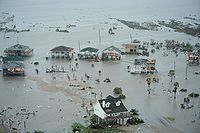
The storm had come ashore hours before daybreak with 110-mph (175 km/h) winds and towering waves, pushing boats ashore, smashing many houses, flooding thousands of homes, knocking out windows in Houston's skyscrapers, uprooting trees, and cutting electric power to more than millions of customers (estimates range from 2.8 million to 4.5 million customers) for weeks or months.
Some people survived by punching holes in attics, climbing to rooftops or trees, using nearby boats, or floating on debris until reaching solid ground.
Afterward, an estimated 100,000 homes had been flooded in Texas, and numerous boats washed ashore. Galveston was declared uninhabitable, and Houston imposed a week-long nighttime curfew due to limited electric power.
Hurricane preparations
Galveston, nearby waterfront towns, and low-lying suburbs of Houston had been partially evacuated.On September 8, Texas
Texas
Texas is the second largest U.S. state by both area and population, and the largest state by area in the contiguous United States.The name, based on the Caddo word "Tejas" meaning "friends" or "allies", was applied by the Spanish to the Caddo themselves and to the region of their settlement in...
State Governor Rick Perry
Rick Perry
James Richard "Rick" Perry is the 47th and current Governor of Texas. A Republican, Perry was elected Lieutenant Governor of Texas in 1998 and assumed the governorship in December 2000 when then-governor George W. Bush resigned to become President of the United States. Perry was elected to full...
declared 88 Texas state counties a disaster area in preparation for Hurricane Ike, expected to hit the Texas coast as early as Saturday morning, which included placing 7,500 Texas Military Forces
Texas Military Forces
The Texas Military Forces is the combined military strength of the U.S. state of Texas. It is composed of three branches, the Texas Army National Guard, the Texas Air National Guard, and the Texas State Guard; all report to the state Adjutant General and are under the command of the Governor of...
troops on standby. The Texas County of Brazoria
Brazoria County, Texas
Brazoria County[p] is a county in the U.S. state of Texas, located on the Gulf Coast within the Houston–Sugar Land–Baytown metropolitan area. Regionally, parts of the county are within the extreme southern-most fringe of the regions locally known as Southeast Texas. Brazoria County is among a...
called for voluntary evacuation and Matagorda County called for mandatory evacuation as did the County of Brazoria for zip code 77541 and the city of Lake Jackson
Lake Jackson, Texas
Lake Jackson is a city in Brazoria County, Texas within the Houston–Sugar Land–Baytown metropolitan area. As of a 2006 U.S. Census Bureau estimate, the city population was 27,614....
. Galveston
Galveston, Texas
Galveston is a coastal city located on Galveston Island in the U.S. state of Texas. , the city had a total population of 47,743 within an area of...
, parts of southern Houston
Houston, Texas
Houston is the fourth-largest city in the United States, and the largest city in the state of Texas. According to the 2010 U.S. Census, the city had a population of 2.1 million people within an area of . Houston is the seat of Harris County and the economic center of , which is the ...
and areas south of the city and near the Texas coast were under a mandatory evacuation order starting at noon September 11.
On September 10, U.S. President George W. Bush
George W. Bush
George Walker Bush is an American politician who served as the 43rd President of the United States, from 2001 to 2009. Before that, he was the 46th Governor of Texas, having served from 1995 to 2000....
made an emergency declaration for Texas in advance of Hurricane Ike, making more federal help available for preparations and evacuations.
State rural water associations activated mutual aid networks to prepare for the landfall of Hurricane Hanna
Hurricane Hanna (2008)
Hurricane Hanna was the deadliest storm of the 2008 Atlantic hurricane season. The storm was the eighth tropical cyclone and fourth hurricane of the 2008 Atlantic hurricane season. It formed east-northeast of the northern Leeward Islands on August 28...
and Hurricane Ike while still providing assistance to areas impacted by Hurricane Gustav
Hurricane Gustav
The name Gustav has been used for five tropical cyclones in the Atlantic Ocean:* 1984's Tropical Storm Gustav - Spent most of its existence as a tropical depression hovering over Bermuda, no major damage was reported....
. The Texas Rural Water Association held meetings with state agencies on Tuesday, September 9, to plan for landfall along the Texas gulf coast.
On September 11, forecasting models began to show Ike making landfall just south of Galveston. City Manager Steve LeBlanc late Wednesday issued a mandatory evacuation order for the low lying west end of Galveston Island
Galveston Island
Galveston Island is a barrier island on the Texas Gulf coast in the United States, about 50 miles southeast of Houston. The entire island, with the exception of Jamaica Beach, is within the city limits of the City of Galveston....
. Later, the mandatory evacuation order was extended to the entire island of Galveston, as well as low-lying areas around Houston, Texas
Houston, Texas
Houston is the fourth-largest city in the United States, and the largest city in the state of Texas. According to the 2010 U.S. Census, the city had a population of 2.1 million people within an area of . Houston is the seat of Harris County and the economic center of , which is the ...
.
Also on September 11, at 8:19 p.m. (CDT), the National Weather Service
National Weather Service
The National Weather Service , once known as the Weather Bureau, is one of the six scientific agencies that make up the National Oceanic and Atmospheric Administration of the United States government...
in Houston/Galveston, TX issued a strongly worded bulletin, regarding storm surge along the shoreline of Galveston Bay
Galveston Bay
Galveston Bay is a large estuary located along the upper coast of Texas in the United States. It is connected to the Gulf of Mexico and is surrounded by sub-tropic marshes and prairies on the mainland. The water in the Bay is a complex mixture of sea water and fresh water which supports a wide...
. The bulletin advised residents living in single-family homes in some parts of coastal Texas may face "certain death" if they do not heed orders to evacuate. Reports said as many as 40 percent of Galveston's citizens may have not paid attention to the warnings. It was feared to be much the same in Port Arthur.
The threat to low-lying areas between Morgan City, Louisiana
Morgan City, Louisiana
Morgan City is a city in St. Martin and St. Mary parishes in the U.S. state of Louisiana. The population was 12,404 at the 2010 census....
, and Baffin Bay, Texas
Baffin Bay, Texas
Baffin Bay is a bay in South Texas, an inlet of the larger Laguna Madre. Located near the Gulf of Mexico, Baffin Bay forms part of the boundary between Kenedy County and Kleberg County.-Etymology:The history of the bay name is unclear...
, east of the projected eye of Hurricane Ike may experience the greatest damage from storm surges of up to 25 feet. Waves at sea are expected to be higher, up to 70 feet according to computer simulations.
The prices of crude oil and gas increased in the expectation of damage to some of the numerous oil refineries along the South Texas coast, or at least delays in production from the oil and gas platforms in the Gulf of Mexico.
Surge measurements
Landfall had been predicted near Freeport, Texas, by the National Hurricane Center, as of Wednesday, 10 September 2008. However, the actual landfall was further east, over the east endof Galveston Island
Galveston Island
Galveston Island is a barrier island on the Texas Gulf coast in the United States, about 50 miles southeast of Houston. The entire island, with the exception of Jamaica Beach, is within the city limits of the City of Galveston....
(near Texas City, TX), with the eye centered over Galveston Bay
Galveston Bay
Galveston Bay is a large estuary located along the upper coast of Texas in the United States. It is connected to the Gulf of Mexico and is surrounded by sub-tropic marshes and prairies on the mainland. The water in the Bay is a complex mixture of sea water and fresh water which supports a wide...
. Because some winds blew from the north at Galveston, water was pushed back out into the Gulf, and the actual storm surge there was muted to 19 ft (5.8 m), rather than the original prediction of over 25 ft (7.6 m) as with a west-end landfall,
which would have pushed more water into Galveston Bay, being a channel bay.
As of 13 September 2008, the highest storm surge had been noted at Sabine Pass
Sabine Pass
Sabine Pass is the natural outlet of Sabine Lake into the Gulf of Mexico. It borders Jefferson County, Texas, and Cameron Parish, Louisiana.Two major battles occurred here during the American Civil War, known as the First and Second Battles of Sabine Pass....
at 22 ft (6.5 m), the highest surge ever recorded at that station, and Ike also brought on the record for greatest storm surge ever seen with any Category 2 hurricane.
However, Bolivar Peninsula, at the entrance to Galveston Bay, was nearer to the eastern side of the eye.
The morning high tide (on 2008-09-13), adding 2.3 ft (0.7 m), occurred at 4:14am CDT at the Galveston Bay entrance.
The total eastern storm tide was then nearly 16 ft (4.9 m) by landfall at 2:10am, with higher waves on top.
Aftermath
On the night of September 12, 2008, the eye of Hurricane Ike approached the Texas coast near Galveston BayGalveston Bay
Galveston Bay is a large estuary located along the upper coast of Texas in the United States. It is connected to the Gulf of Mexico and is surrounded by sub-tropic marshes and prairies on the mainland. The water in the Bay is a complex mixture of sea water and fresh water which supports a wide...
, making landfall at 2:10 a.m. CDT over the east end of Galveston Island
Galveston Island
Galveston Island is a barrier island on the Texas Gulf coast in the United States, about 50 miles southeast of Houston. The entire island, with the exception of Jamaica Beach, is within the city limits of the City of Galveston....
(near Texas City).
People in low-lying areas who had not heeded evacuation orders, in single-family one- or two-story homes, had been warned by the weather service that they "faced certain death" in the overnight storm surge
Storm surge
A storm surge is an offshore rise of water associated with a low pressure weather system, typically tropical cyclones and strong extratropical cyclones. Storm surges are caused primarily by high winds pushing on the ocean's surface. The wind causes the water to pile up higher than the ordinary sea...
.
In regional Texas towns, electrical power began failing before 8 p.m. CDT,
leaving more than 3 million people without power. In addition, grocery store shelves in the Houston area were left empty.
Rainfall estimates indicated that 2-day rainfall totals from mid-day Friday through mid-day Saturday exceeded 20 inches (50 cm) in parts of both northern Harris County
Harris County, Texas
As of the 2010 Census, the population of the county was 4,092,459, White Americans made up 56.6% of Harris County's population; non-Hispanic whites represented 33.0% of the population. Black Americans made up 18.9% of the population. Native Americans made up 0.7% of Harris County's population...
and southern Montgomery County
Montgomery County, Texas
Montgomery County is a county located in the U.S. state of Texas within the Houston–Sugar Land–Baytown metropolitan area. The county was created by an act of the Congress of the Republic of Texas on December 14, 1837. The county was named for the town of Montgomery, Texas. In 2000, its...
, with a multi-county area receiving at least 10 inches (25 cm) of rainfall.
Bolivar Peninsula and southern Chambers County

Most, if not all of the communities previously located on the Bolivar Peninsula, which together with Galveston Island
Galveston Island
Galveston Island is a barrier island on the Texas Gulf coast in the United States, about 50 miles southeast of Houston. The entire island, with the exception of Jamaica Beach, is within the city limits of the City of Galveston....
separates Galveston Bay
Galveston Bay
Galveston Bay is a large estuary located along the upper coast of Texas in the United States. It is connected to the Gulf of Mexico and is surrounded by sub-tropic marshes and prairies on the mainland. The water in the Bay is a complex mixture of sea water and fresh water which supports a wide...
from the Gulf of Mexico
Gulf of Mexico
The Gulf of Mexico is a partially landlocked ocean basin largely surrounded by the North American continent and the island of Cuba. It is bounded on the northeast, north and northwest by the Gulf Coast of the United States, on the southwest and south by Mexico, and on the southeast by Cuba. In...
, were utterly devastated. Based on an extensive aerial survey conducted on the afternoons of Saturday, September 13 and Sunday, September 14, very little remains west of the community of High Island
High Island, Texas
High Island is an unincorporated area located in the Bolivar Peninsula census-designated place, Galveston County, Texas, United States. The community is located in the extreme eastern part of the county on Bolivar Peninsula, less than one mile from Chambers County and less than two miles from...
. The area of total or near-total destruction includes Caplen, Port Bolivar, and the area surrounding Gregory Park. Most, if not all of the structures that had been situated along the length of Highway 87 west of High Point, as well as Highway 108 on the western edge of Bolivar, were destroyed.

Gilchrist, Texas
Gilchrist, Texas is an unincorporated residential community and beachfront resort along State Highway 87, located seventeen miles east of Bolivar Point in the Bolivar Peninsula census-designated place, in Galveston County, Texas, United States....
, which sat astride the north-facing Rollover Bay on Bolivar, was completely swept away, save for only a few homes. One of these homes, the only one in its neighbourhood to remain intact (although it was rendered uninhabitable), attracted widespread media interest after images of it began to appear in newspapers and on television. At least six bodies were found in an extensive search.
Two flood water sensors in Chambers County, Texas survived Ike's storm surge, while those on eastern Bolivar Peninsula were left inoperable during the hurricane. Along the Eastern shores of Galveston Bay surge heights were measured at 16.9 feet (5.15 m) and a measurement along SH126 measured 17.0 feet (5.18 m). Massive amounts of surge carried debris, largely from Bolivar Peninsula and southern Chambers County were left along the northern coast of Rollover bay Chambers county.
Galveston
In GalvestonGalveston, Texas
Galveston is a coastal city located on Galveston Island in the U.S. state of Texas. , the city had a total population of 47,743 within an area of...
, by 4 p.m. CDT (2100 UTC) on September 12, the rising storm surge began overtopping the 17-ft (5.2 m) Galveston Seawall
Galveston Seawall
The Galveston Seawall is a seawall in Galveston, Texas, USA that was built after the Galveston Hurricane of 1900 for protection from future hurricanes. Construction began in September, 1902, and the initial segment was completed on July 29, 1904. From 1904 to 1963, the seawall was extended from ...
, which faces the Gulf of Mexico; waves had been crashing along the seawall earlier, from 9 a.m. CDT.
Although Seawall Boulevard is elevated above the shoreline, many areas of town slope down behind the seawall to the lower elevation of Galveston Island
Galveston Island
Galveston Island is a barrier island on the Texas Gulf coast in the United States, about 50 miles southeast of Houston. The entire island, with the exception of Jamaica Beach, is within the city limits of the City of Galveston....
.
The historic Balinese Room
Balinese Room
The Balinese Room was a well-known nightclub in Galveston, Texas, United States built on a pier stretching 600 feet from the Galveston Seawall over the waters of the Gulf of Mexico...
, a former mafia-run nightclub that had extended 600 feet into the Gulf of Mexico and had withstood many serious storms, was swept away as Ike's eye crossed over the eastern half of Galveston Island. The elevated structure, which had hosted performers ranging from Frank Sinatra
Frank Sinatra
Francis Albert "Frank" Sinatra was an American singer and actor.Beginning his musical career in the swing era with Harry James and Tommy Dorsey, Sinatra became an unprecedentedly successful solo artist in the early to mid-1940s, after being signed to Columbia Records in 1943. Being the idol of the...
, Bob Hope
Bob Hope
Bob Hope, KBE, KCSG, KSS was a British-born American comedian and actor who appeared in vaudeville, on Broadway, and in radio, television and movies. He was also noted for his work with the US Armed Forces and his numerous USO shows entertaining American military personnel...
and George Burns
George Burns
George Burns , born Nathan Birnbaum, was an American comedian, actor, and writer.He was one of the few entertainers whose career successfully spanned vaudeville, film, radio, television and movies, with and without his wife, Gracie Allen. His arched eyebrow and cigar smoke punctuation became...
to Groucho Marx
Groucho Marx
Julius Henry "Groucho" Marx was an American comedian and film star famed as a master of wit. His rapid-fire delivery of innuendo-laden patter earned him many admirers. He made 13 feature films with his siblings the Marx Brothers, of whom he was the third-born...
and Sammy Davis, Jr.
Sammy Davis, Jr.
Samuel George "Sammy" Davis Jr. was an American entertainer and was also known for his impersonations of actors and other celebrities....
, had recently been renovated and returned to profitability after years of neglect and disrepair, and was listed on the National Registry of Historically Significant Places. The rock band ZZ Top
ZZ Top
ZZ Top is an American rock band, sometimes referred to as "That Little Ol' Band from Texas". Their style, which is rooted in blues-based boogie rock, has come to incorporate elements of arena, southern, and boogie rock. The band, from Houston Texas, formed in 1969...
had a song named after the popular destination, "Balinese".
None of the many wooden piers that gave Galveston much of its unique character survived the landfall of Hurricane Ike. In addition to the Balinese Room, Murdoch's, Hooters
Hooters
Hooters is the trade name of two privately held American restaurant chains: Hooters of America, Incorporated, based in Atlanta, Georgia, and Hooters, Incorporated, based in Clearwater, Florida...
and the 61st Street Pier were all completely destroyed.
(Murdoch's Pier was rebuilt and reopened in October 2009, while Hooters Galveston (housed in the former Ocean Grill building) was not rebuilt; the site remains vacant as of 2011. Because of the recession, Texas Wings (the subsidary of Hooters of America based out of Dallas, TX) executives have no future plans to reestablish a Hooters franchise in Galveston. The 61st Street Pier was rebuilt and reopened in 2010.) Seawall Boulevard, which runs the entire length of the seawall several meters above the popular beaches adjoining the Gulf, was littered with the debris of these and other structures.
The landmark Flagship Hotel
USS Flagship Hotel
The USS Flagship Hotel was a hotel, located in Galveston in the U.S. state of Texas. It was built on the historic Pleasure Pier structure entirely over the Gulf of Mexico, albeit very close to shore. It was a popular destination in Galveston that withstood many storms.-History:The hotel was built...
, which sits on deep concrete pylons, was seriously damaged, but no one was injured, and an early survey indicates the structure will be salvageable. Some of the hotel's siding was peeled off by the storm (this occurred during Hurricane Alicia
Hurricane Alicia
Hurricane Alicia was the costliest tropical cyclone in the Atlantic since Hurricane Agnes in 1972. Alicia was the third depression, the first tropical storm, and the only major hurricane of the 1983 Atlantic hurricane season...
in 1983), venting at least one top-floor guest suite to the open air, and the elevated ramp permitting vehicles to access the hotel's lower level from Seawall Boulevard fell into the Gulf.
The seemingly protected back side of the island also suffered heavy damage to tourist areas. The Lone Star Flight Museum
Lone Star Flight Museum
The Lone Star Flight Museum, located in Galveston, Texas, USA, is an aerospace museum that displays more than 40 historically significant aircraft and many hundreds of artifacts related to the history of flight. The museum's collection is rare because most of the aircraft are flyable...
suffered massive damage as the storm surge washed over the airport and though all the aircraft hangars (not just the museums) with about 8 feet of water. All the airplanes, except those that flew out before the storm, where damaged from moderate to severe, but the worst was the complete destruction of the "Aviation Hall of Fame" with numerous personal items of aviations greatest pioneers. As of August 2011, plans are underway to relocate the Lone Star Flight Museum to Ellington Field
Ellington Field
Ellington International Airport is a joint civil-military airport located in the U.S. state of Texas within the city of Houston— southeast of Downtown. Established by the Army Air Service on 21 May 1917, Ellington Field was one of the initial World War I Army Air Service installations when...
even though a 20 year lease extension from Scholes Field was signed. The recently completed Schlitterbahn Water Park
Schlitterbahn
Schlitterbahn is a family-owned and operated company based in New Braunfels, Texas, USA. Schlitterbahn began its first park, Schlitterbahn Waterpark Resort, in 1979. Since then Schlitterbahn has developed three waterparks located in Texas and one in Kansas City, Kansas.Schlitterbahn Waterparks are...
is still closed as of November as they continue to work on repairs Conversely, Moody Gardens
Moody Gardens
Moody Gardens is a tourist complex in Galveston, Texas. It is owned, through a complex agreement, by the City of Galveston but funded, operated, and supported by the multi-billion dollar Moody Foundation....
was built with hurricane storms in mind with strong pyramid shaped structures very high above sea level, so it was able to withstand the worst of the storm and return to operation quickly.
Even though there were advance evacuation plans, Mary Jo Naschke, spokesperson for the city of Galveston, estimated that (as of Friday morning) a quarter of the city's residents disregarded calls for them to evacuate, despite predictions that most of Galveston Island would suffer heavy flooding storm tide
Storm tide
A storm tide is a tide with a high flood period caused by a storm. Storm tides can be a severe danger to the coast and the people living along the coast. The water level can rise to more than 5 meters above the normal tide....
. By 6 p.m. Friday night, estimates varied as to how many of the 58,000 residents remained, but the figures of remaining residents were in the thousands.
An early survey of Galveston Island, performed late Saturday, September 13 and Sunday, September 14, 2008, indicated that the entirety of the Island west of 11 Mile Road was entirely devastated, and that few structures on Galveston's western one-third had survived. This area of near-total destruction includes the communities of Bayou Vista
Bayou Vista, Texas
Bayou Vista is a city in Galveston County, Texas, United States. The population was 1,644 at the 2000 census. It received severe damage from Hurricane Ike on September 13, 2008.-Geography:Bayou Vista is located at ....
and Jamaica Beach
Jamaica Beach, Texas
Jamaica Beach is a city in Galveston County, Texas, United States. As of the 2000 census, the city population was 1,075.-History:Prior to its development, Jamaica Beach was a Karankawa burial ground. Johnny Goyen and Earl Galceran of the Jamaica Corporation developed Jamaica Beach as a 2,000-lot...
, as well as the Galveston Country Club and the Galveston Island State Park
Galveston Island State Park
Galveston Island State Park, in Galveston County, is in the City of Galveston, Texas on the west end of Galveston Island. It is a site that was acquired in 1969 from private owners under the State Parks Bond Program and was opened in 1975. On September 14, 2008, the park was closed due to damage...
. The affected area previously included some 1,000 structures, including single-family dwellings, commercial enterprises, and hotels and resorts. It is unknown how many residents may have ignored repeated calls to evacuate, or what became of those who decided to remain in Galveston's vulnerable West End.
Electric power failed in Galveston around 7:45 p.m. CDT.
Widespread flooding included downtown Galveston: such as 6-ft (2 m) deep inside the Galveston County Courthouse, and the University of Texas Medical Branch at Galveston was flooded. Five people have died on Galveston Island - two of them drowned and three of them were due to natural causes.
Transfer of survivors: In transferring survivors out of town, Galveston officials planned to use Ball High School, which was being used as a "shelter of last resort" for evacuees, to be a center for FEMA. More than 200 residents had been staying at the school shelter, and hundreds more were eating meals there. Buses were brought in on Sunday to take residents from that shelter, and others who wanted to leave the island, to a shelter in San Antonio.
On the day of landfall, police were stopping travelers at La Marque, 4 miles (6 km) north of Galveston, and making them exit the highway. Interstate 45 at La Marque had been closed because boats and parts of wrecked piers were strewn throughout floodwaters blocking the road.
From a historical perspective, on September 8, 1900, the Great Galveston Hurricane came ashore on a path similar to Ike, bringing with it a storm surge that inundated most of Galveston Island: as a result, much of the city was destroyed and at least 6,000 people were killed in a few hours; afterward, the level of the island was raised an average of 4 ft (1.3 m), adding a high seawall (17-ft, 5.2 m) to block incoming waves.
The annual Lone Star Motorcycle Rally, usually held in late October or early November, was rescheduled to December 2008. The economic impact after Ike have affected Galveston businesses - the hardest hit was in the Strand where a few vacant building spaces sit empty. A new promoter for the annual Mardi Gras celebration, Yaga's Entertainment Inc. signed a 5 year contract with the City of Galveston where admission fees are charged on both weekends prior to Fat Tuesday, angering revelers, businessowners, and tourists despite the effects of the late-2000s recession.
Houston

JPMorgan Chase Tower (Houston)
JPMorgan Chase Tower, formerly Texas Commerce Tower, is a , 75-story skyscraper in Houston, Texas. It is currently the tallest building in the city, the tallest building in Texas, the tallest five-sided building in the world, 12th tallest building in the United States, and the 54th tallest building...
, and Reliant Stadium
Reliant Stadium
Reliant Stadium is a multi-purpose stadium, in Houston, Texas, USA. Reliant Stadium has a seating capacity of 71,500, a total square footage of with of natural grass playing surface....
was damaged. According to a witness interviewed by FoxNews, furniture from offices in the JPMorgan Chase building was blown out of the shattered windows and into the parking garage across the street. A fire partially burned Brennan's restaurant in downtown Houston, but workers were rescued. Many trees were uprooted, and bus stop shelters were mangled. Houston's theater district was flooded.
Although electric power was out in most of the region, the lights remained on at the Texas Medical Center
Texas Medical Center
The Texas Medical Center is the largest medical center in the world with one of the highest densities of clinical facilities for patient care, basic science, and translational research...
, a complex of about a dozen hospitals. At Memorial Hermann Hospital
Memorial Hermann Hospital
Memorial Hermann Healthcare System is the largest not-for-profit hospital system in Houston, Texas, and consists of 11 hospitals, 7 Cancer Centers, 3 Heart & Vascular Institutes, and 27 sports medicine and rehabilitation centers, in addition to other outpatient and rehabilitation centers. It was...
, patients were coming in with a variety of problems, including people who had run out of medicine or oxygen, or others who had cuts and bruises.
Eight deaths have been blamed on Ike in Houston, all of which were indirect in cleanup incidents such as carbon monoxide
Carbon monoxide
Carbon monoxide , also called carbonous oxide, is a colorless, odorless, and tasteless gas that is slightly lighter than air. It is highly toxic to humans and animals in higher quantities, although it is also produced in normal animal metabolism in low quantities, and is thought to have some normal...
poisoning from generators used or fires from light sources while power was out, or accidents involving tree cutting.
Hurricane Ike affected Houston Astros
Houston Astros
The Houston Astros are a Major League Baseball team located in Houston, Texas. They are a member of the National League Central division. The Astros are expected to join the American League West division in 2013. Since , they have played their home games at Minute Maid Park, known as Enron Field...
' late dash for Major League Baseball's playoffs, indefinitely postponing Friday and Saturday's games against the Chicago Cubs
Chicago Cubs
The Chicago Cubs are a professional baseball team located in Chicago, Illinois. They are members of the Central Division of Major League Baseball's National League. They are one of two Major League clubs based in Chicago . The Cubs are also one of the two remaining charter members of the National...
.
Flights in and out of Houston's two major airports (Bush Intercontinental and Hobby) were suspended on Friday September 12, 2008, with plans to resume on the following Sunday. However, as of Sunday September 14, 2008, Intercontinental remained without power, but both airports planned to re-open Monday with limited service.
Due to large number of destroyed, damaged, or dysfunctional traffic lights, most Houston roads remain clogged two weeks after Ike hit. Many highway exits are jammed and cause a gridlock on highways as well, especially during rush hours. Many gas stations were out of service for a week because of no electricity to pump the gas out of the ground, and few that functioned had long lines and only once a week gasoline deliveries. This "hit and miss" to find gasoline led to the buying out of gasoline once it was delivered. Similarly there were long lines in most of the few open grocery stores, home repair stores, and restaurants.
Texas City
A Valero Energy Corp. spokesman, Bill Day, said that crews would soon get in to inspect the oil refineriesOil refinery
An oil refinery or petroleum refinery is an industrial process plant where crude oil is processed and refined into more useful petroleum products, such as gasoline, diesel fuel, asphalt base, heating oil, kerosene, and liquefied petroleum gas...
in Houston and Texas City, which remained shut down on Saturday, 13 September 2008. Texas City (north of Galveston) was very near to the landfall site of Hurricane Ike. The Mainland Medical Center (off I-45) closed its doors on Saturday (13Sep08) at 4 p.m. CDT, after water service was unavailable in the area. One death has been reported in Texas City, which was caused by a lack of dialysis treatment due to the storm's aftermath.
The beloved Texas City Dike
Texas City Dike
The Texas City Dike is a levee located in Texas City, TX that projects nearly south-east into the mouth of Galveston Bay. It is flanked by the north-eastern tip of Galveston Island and the south-western tip of the Bolivar Peninsula...
, a manmade structure extending nearly five miles into the mouth of Galveston Bay
Galveston Bay
Galveston Bay is a large estuary located along the upper coast of Texas in the United States. It is connected to the Gulf of Mexico and is surrounded by sub-tropic marshes and prairies on the mainland. The water in the Bay is a complex mixture of sea water and fresh water which supports a wide...
, was overtopped and seriously damaged along with all structures built upon it. The dike, known to locals as "the world's longest manmade fishing pier," had stood for seven decades and was considered Texas City's primary defense against the devastation wrought by a powerful storm surge
Storm surge
A storm surge is an offshore rise of water associated with a low pressure weather system, typically tropical cyclones and strong extratropical cyclones. Storm surges are caused primarily by high winds pushing on the ocean's surface. The wind causes the water to pile up higher than the ordinary sea...
.
An aerial survey late afternoon Sunday, September 14, revealed that the eastern and northern portions of Texas City, as well as San Leon were still substantially flooded. Substantial wind damage appeared to have been sustained by the Texas City Industrial Complex that borders Galveston Bay.
A few businesses, including some gasoline stations, convenience stores and fast food restaurants, were planning to re-open as early as Monday, September 15, 2008. Beginning Sunday, September 14, the Texas Military Forces
Texas Military Forces
The Texas Military Forces is the combined military strength of the U.S. state of Texas. It is composed of three branches, the Texas Army National Guard, the Texas Air National Guard, and the Texas State Guard; all report to the state Adjutant General and are under the command of the Governor of...
began using the city's high school football stadium as a staging and relocation area used by Black Hawk helicopters, which were used to retrieve stranded citizens from Bolivar, Galveston and other area communities. Also on September 14, the Red Cross opened a disaster relief center in Texas City.
League City
In League City, TX, the electric power went out, and CenterPoint Energy said it could take four weeks or more to restore power after the largest outage in the company's history.Residents who evacuated were allowed to return on 16 September 2008 and advised to bring back enough food for two weeks; a dusk-until-dawn curfew was in effect. Two deaths have been reported in League City, both due to natural causes indirectly caused by Ike.
Kemah, Seabrook, Taylor Lake Village and El Lago

Kemah, Texas
Kemah is a city in the U.S. state of Texas within the Houston–Sugar Land–Baytown metropolitan area. The city's population was 2,330 as of the 2000 census. Located in Galveston County, Kemah's main industry comes from shipping...
, about 35 miles (56 km) south of Houston, was without power and water, and still had 5 feet of flooding on Saturday, 13 September 2008. State Highway 146 was closed at the 2094 intersection. There was a lot of debris on the roads, completely covering some lanes.
Severe damage occurred at the Kemah Boardwalk
Kemah Boardwalk
The Kemah Boardwalk is a hotel and restaurant destination in Kemah, Texas, USA. The main attractions of the complex, which opened in 2001, are its many restaurants overlooking Galveston Bay. The area was developed by Landry's Restaurants, which owns all of the restaurants on the boardwalk...
, the site of many popular restaurants and shops, as well as a small waterfront amusement park with various rides, including a carousel, kiddie train and Ferris wheel
Ferris wheel
A Ferris wheel is a nonbuilding structure consisting of a rotating upright wheel with passenger cars attached to the rim in such a way that as the wheel turns, the cars are kept upright, usually by gravity.Some of the largest and most modern Ferris wheels have cars mounted on...
overlooking Galveston Bay. The entire first floor of Landry's seafood restaurant was demolished and swept away, as well as those of neighboring structures. The Boardwalk had received 4 million visitors per year.
In an interview on local CBS affiliate KHOU-TV
KHOU-TV
KHOU is the CBS affiliate television station in Houston, Texas. Serving Greater Houston, it is owned by the Belo Corporation and broadcasts on digital and PSIP channel 11...
, the Boardwalk manager expressed confidence that despite such unprecedented devastation to the tourist attraction, the site would be rebuilt.
In Seabrook, most homes and businesses east of State Highway 146 (close to Galveston Bay) were flooded by storm surge, which included the Miramar subdivision and "Old Seabrook". Homes along Todville Rd (which parallels Galveston Bay) were washed away, or had their entire bottom floors gutted. State Highway 146 just north of the Kemah Bridge was completely inundated, causing boats and other debris to collect on the highway after the waters subsided. The Seabrook Waterfront district sustained substantial damage. The surge caused boats to float onto or very close to Nasa Road 1.. also destroyed boat docks and businesses along Nasa Road 1 all the way to the Nassau Bay Hilton hotel.
Clear Lake and Nassau Bay
Near Clear LakeClear Lake (Galveston Bay)
Clear Lake is a brackish lake located near Houston, Texas, USA in Harris County. The lake feeds Galveston Bay. It is bordered by Houston , Pasadena, League City, Clear Lake Shores, Taylor Lake Village, and El Lago, Texas...
, where winds reportedly gusted over 100 mph, many people rode out the storm at the Nassau Bay Hilton, across from the NASA/JSC complex. The roof of the Mission Control Center of NASA's Johnson Space Center was damaged by Hurricane Ike, but there were no injuries and no major flooding. Along with the roof damage, there were branches and light poles on the ground, with minor damage to buildings and vehicles. There was also damage to hangars and awnings over at NASA's Ellington Field
Ellington Field
Ellington International Airport is a joint civil-military airport located in the U.S. state of Texas within the city of Houston— southeast of Downtown. Established by the Army Air Service on 21 May 1917, Ellington Field was one of the initial World War I Army Air Service installations when...
,
east of I-45. NASA has its own generators to provide electric power.
Baytown
Baytown, on the upper portion of Galveson Bay, was affected by the storm surge from Hurricane Ike. Homes in the Lakewood subdivision on the western side of Baytown on the bay sustained major flood damage. The Bayland Marina on the Waterfront District near Hwy 146 sustained major damage. All boats docked there were lost. Most of the boats were found along Hwy 146 or in the nearby subdivision. Hurricane Ike also caused the temporary shutting down of the Baytown ExxonMobil refinery.Jefferson County

East Texas
East Texas is a distinct geographic and ecological area in the U.S. state of Texas.According to the Handbook of Texas, the East Texas area "may be separated from the rest of Texas roughly by a line extending from the Red River in north central Lamar County southwestward to east central Limestone...
, the Beaumont
Beaumont, Texas
Beaumont is a city in and county seat of Jefferson County, Texas, United States, within the Beaumont–Port Arthur Metropolitan Statistical Area. The city's population was 118,296 at the 2010 census. With Port Arthur and Orange, it forms the Golden Triangle, a major industrial area on the...
and Port Arthur
Port Arthur, Texas
-Demographics:As of the 2000 census, there were 57,755 people, 21,839 households, and 14,675 families residing in the city. The population density was 696.5 people per square mile . There were 24,713 housing units at an average density of 298.0 per square mile...
areas received winds at hurricane force. Ike's storm surge threatened the Port Arthur levees, and penetrated far enough inland to contaminate the water supply for Beaumont with salt water.
Hardest hit were rural areas of Jefferson County, including the unincorporated communities of LaBelle
LaBelle, Texas
LaBelle is an unincorporated community on Taylor Bayou and FM 365, ten miles south of Beaumont, in central Jefferson County, Texas, United States. It is part of the Beaumont–Port Arthur Metropolitan Statistical Area...
and Fannett
Fannett, Texas
Fannett is an unincorporated town in Jefferson County, Texas, United States, about 15 miles southwest of Beaumont. It is part of the Beaumont–Port Arthur Metropolitan Statistical Area. The community is named after B. J. Fannett, a local landowner who opened a general store there in the 1890s...
. As of Sept 18, 4000 head of cattle were estimated dead, drowned by floods in the county, both from rain, and storm surge.
One fatality has been reported in extreme Southeast Texas related to Ike. It was as a result of a generator fire when power was out. Despite official assurances that this was the only Ike-related death in the area, rumors spread that large numbers of people died during the storm. This was fueled by the presence of refrigerated trailers outside a Beaumont funeral home. The funeral home had lost electrical service and was using the trailers to store bodies of people who died of natural causes until burials could be arranged.
Orange County
Damage was widespread and severe across Orange County. Storm surge almost completely flooded Bridge CityBridge City, Texas
Bridge City is a city in Orange County, Texas, United States. The population was 8,651 at the 2000 census. The town borders the Neches River and Cow Bayou. It is part of the Beaumont–Port Arthur Metropolitan Statistical Area....
, breached the levee at the City of Orange, and travelled up the Neches River
Neches River
The Neches River flows for through east Texas to its mouth on Sabine Lake near the Rainbow Bridge. Two major reservoirs, Lake Palestine and B. A. Steinhagen Reservoir are located on the Neches. Several cities are located along the Neches River Basin, including Evadale, Tyler, Lufkin, Silsbee,...
to flood Rose City
Rose City, Texas
Rose City is a city three miles east of Beaumont in Orange County, Texas, United States. The population was 519 at the 2000 census. It is part of the Beaumont–Port Arthur Metropolitan Statistical Area.-Geography:...
.
The City of Orange
Orange, Texas
Orange is a city in Orange County, Texas, United States. As of the 2000 census, the city population was 18,643. It is the county seat of Orange County, and is the easternmost city in Texas. Located on the Sabine River at the border with Louisiana, it is part of the Beaumont–Port Arthur...
received winds at hurricane force. Mayor Brown Claybar estimated about a third of the city of 19,000 people was flooded, anywhere from 6 inches (15 cm) to 6 feet (2 m). He said about 375 people, of those who stayed behind during the storm, began to emerge, some needing food, water and medical care. Many dead fish littered streets and properties.
Bridge City Mayor Kirk Roccaforte estimated that only 14 homes in the city were unaffected by the surge. 5 of which were in the Oakview addition on Louise Street. The piles of debris and waterlogged furniture placed outside homes by residents beginning to clean up led the mayor to say "The whole city looks like a flea market. During the post-storm cleanup, Bridge City residents found swimming pools had been occupied by jellyfish brought inland with the water. Three people were found dead in Orange County on September 29.
Corpus Christi
Corpus Christi, TX received winds at tropical-storm force. Near Corpus Christi, a man was reportedly swept away; he is presumed dead. The Coast Guard searched for his body after the storm has passed.Wal-Mart Stores Inc. reopened 7 stores in the Corpus Christi area on Saturday, 13 September 2008.
Other towns

Montgomery County, Texas
Montgomery County is a county located in the U.S. state of Texas within the Houston–Sugar Land–Baytown metropolitan area. The county was created by an act of the Congress of the Republic of Texas on December 14, 1837. The county was named for the town of Montgomery, Texas. In 2000, its...
while being cut in preparation for the storm, and another person was killed not far away from a fallen tree during the storm. After the storm, another tree-cutting accident involving a damaged tree killed another young boy in Montgomery County, and a cleanup accident involving a truck resulted in a fourth death in the county. Another fallen tree in Huntsville
Huntsville, Texas
Huntsville is a city in and the county seat of Walker County, Texas, United States. The population was 35,508 at the 2010 census. It is the center of the Huntsville micropolitan area....
resulted in a fatality after it crashed into a house. In Anahuac
Anahuac, Texas
Anahuac is a city in the U.S. state of Texas within the Houston–Sugar Land–Baytown metropolitan area. The population of the city was 2,210 at the 2000 census. Anahuac is the seat of Chambers County and is situated in East Texas.- History :...
, one person was electrocuted in the preparations, and one person was killed by a house fire while without power in Walker County
Walker County, Texas
Walker County is a county located in the U.S. state of Texas. In 2010, its population was 67,861. Its county seat is Huntsville.Initially, Walker County was named for Robert J. Walker, a legislator from Mississippi who introduced into the United States Congress the resolution to annex Texas...
.
On Goat Island, there were reports of a herd of cattle and other livestock that survived the storm, although it was unclear from where they had arrived onto the narrow sandbar.
In San Leon, the popular Topwater Grill restaurant, that stood at the tip of a promontory extending into Galveston Bay
Galveston Bay
Galveston Bay is a large estuary located along the upper coast of Texas in the United States. It is connected to the Gulf of Mexico and is surrounded by sub-tropic marshes and prairies on the mainland. The water in the Bay is a complex mixture of sea water and fresh water which supports a wide...
, was swept away by Ike's powerful storm surge. The eatery had featured fresh local seafood "right off the boat," with a small fleet of fishing vessels that pulled right up to its doors with each day's catch. It also offered dock space to patrons who arrived by boat or other personal water craft.
Also in San Leon, three members of a family that had opted to ride out the storm were still missing as of midnight, Monday, September 15, 2008. One person in San Leon drowned.
The storm brought to San Leon a large herd of parrots which have nested between a number of the power transformers and the power poles along Bayview Drive near the county park. The noise from these birds can be heard throughout the park. Several roofing companies have experienced these parrots making threatening passes at their workers while trying to make repairs on the roofs in the community.
Tiki Island, a low-lying waterfront community bordered by North Bay and West Bay along Interstate Highway 45, sustained extensive water damage, but most of the structures remained intact.
The neighborhood of Bayou Vista
Bayou Vista, Texas
Bayou Vista is a city in Galveston County, Texas, United States. The population was 1,644 at the 2000 census. It received severe damage from Hurricane Ike on September 13, 2008.-Geography:Bayou Vista is located at ....
, just north of Tiki Island at the intersection of IH-45, State Highway 6 and State Highways 3 and 146, was substantially damaged.
The bayfront community of Virginia Point, on the other side of the Bay from Galveston Island, was swept away.
Electrical outages
CenterPoint EnergyCenterPoint Energy
CenterPoint Energy is a Fortune 500 electric and natural gas utility serving several markets in the U.S. states of Arkansas, Louisiana, Minnesota, Mississippi, Oklahoma, and Texas. It was formerly known as Reliant Energy , NorAm Energy, Houston Industries, and HL&P...
, the largest power company in the region, said that it had restored power to 112,000 homes and business on Saturday, plus many of Houston's skyscrapers had regained power. The progress was as follows:
- by Saturday evening, 112,000 customers had power;
- by Sunday noon, 262,000 customers had power;
- by Tuesday 9 p.m., 750,000 customers had power.
However, over 1.5 million people remained without power as of Sept. 16, 2008.
Entergy Texas, whose service area includes Beaumont-Port Arthur west to cities north of Houston such as The Woodlands and Conroe, estimated that 392,600 of their 395,000 customers lost power during Ike. Although nearly all their customers lost power, the company reported restoration of electrical service to all customers who could safely receive power on September 25, twelve days after the storm. The majority of Entergy customers unable to receive power were located in High Island and on the Bolivar Peninsula.
Offshore ships and oil rigs
On Saturday, September 13, 2008, the US Coast Guard sent the tugboat Rotterdam to rescue the crew of a disabled freighter, Antalina, carrying 22 people, hours after the ship had survived Hurricane Ike, without any means of escaping.Repairs to the ship's broken fuel pump will be made at sea; the tugboat will then tow the ship to Port Arthur, Texas
Port Arthur, Texas
-Demographics:As of the 2000 census, there were 57,755 people, 21,839 households, and 14,675 families residing in the city. The population density was 696.5 people per square mile . There were 24,713 housing units at an average density of 298.0 per square mile...
, to be anchored for additional repairs and eventually to offload more of its cargo: petroleum coke
Petroleum coke
Petroleum coke is a carbonaceous solid derived from oil refinery coker units or other cracking processes. Other coke has traditionally been derived from coal....
, a petroleum byproduct.
Two oil rigs were adrift in the Gulf of Mexico
Gulf of Mexico
The Gulf of Mexico is a partially landlocked ocean basin largely surrounded by the North American continent and the island of Cuba. It is bounded on the northeast, north and northwest by the Gulf Coast of the United States, on the southwest and south by Mexico, and on the southeast by Cuba. In...
, but crews had prepared to secure both rigs as soon as the water conditions settled.
As of Sept. 19, a revised total of 49 oil and gas platforms, of the 3,800 in the Gulf, were considered destroyed (compared with 44 destroyed during Hurricane Katrina).
BP reported that the drilling derrick (tower) on its Mad Dog platform had been toppled into the sea, adding that it was too early to predict when the platform could resume production.
Oil refineries
There were 14 oil refineriesOil refinery
An oil refinery or petroleum refinery is an industrial process plant where crude oil is processed and refined into more useful petroleum products, such as gasoline, diesel fuel, asphalt base, heating oil, kerosene, and liquefied petroleum gas...
in the affected region, and 8 were known to have survived with little flooding.
Emergency shelters
Several communities accepted thousands of evacuees, or later refugees, from the impact areas, including:- In Galveston, Ball High School held 200 evacuees (as a "shelter of last resort"), plus providing meals to hundreds more.
- In San Antonio, about 219 miles (352 km) from Galveston, shelters held nearly 5,000 evacuees.
- In Tyler, about 200 miles (320 km) inland, 3,400 evacuees took temporary refuge, and it became clear that some shelters would not suffice for long-term evacuation.
- More than 4,000 people rode out the storm in tents, campers and RVs, according to the Texas Parks and Wildlife Department.
There were other shelters as well.
Recovery
Response teams from the Texas Rural Water Association moved from their staging area in Mauriceville, Texas the day after landfall. They distributed emergency generators to impacted systems, some as early as eight hours after the loss of water service.See also
- Hurricane IkeHurricane IkeHurricane Ike was the second-costliest hurricane ever to make landfall in the United States, the costliest hurricane ever to impact Cuba and the second most active hurricane to reach the Canadian mainland in the Great Lakes Region after Hurricane Hazel in 1954...
- main storm article for Ike - Effects of Hurricane Ike in inland North AmericaEffects of Hurricane Ike in inland North AmericaThe effects of Hurricane Ike in inland North America were unusually intense and included widespread damage across all or parts of eleven states - Arkansas, Illinois, Indiana, Kentucky, Michigan, Missouri, New York, Ohio, Pennsylvania, Tennessee and West Virginia, and into parts of Ontario as Ike,...
- 1900 Galveston Hurricane - the catastrophic Category 4 hurricane for which the city of Galveston is famous
- Hurricane GustavHurricane GustavThe name Gustav has been used for five tropical cyclones in the Atlantic Ocean:* 1984's Tropical Storm Gustav - Spent most of its existence as a tropical depression hovering over Bermuda, no major damage was reported....
- another 2008 Category 4 storm that existed prior to Hurricane Ike - 2008 Atlantic hurricane season2008 Atlantic hurricane seasonThe 2008 Atlantic hurricane season was a very active hurricane season with sixteen named storms formed, including eight that became hurricanes and five that became major hurricanes. The season officially started on June 1 and ended on November 30. These dates conventionally delimit the period of...
External links
- National Hurricane Center: NHC homepage.
- Houston Chronicle electric progress: Ike Power Map.
- Harris County Housing Authority DHAP programs: Beyond Boxes.