

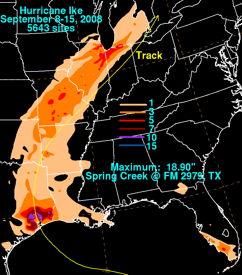
Effects of Hurricane Ike in inland North America
Encyclopedia
Arkansas
Arkansas is a state located in the southern region of the United States. Its name is an Algonquian name of the Quapaw Indians. Arkansas shares borders with six states , and its eastern border is largely defined by the Mississippi River...
, Illinois
Illinois
Illinois is the fifth-most populous state of the United States of America, and is often noted for being a microcosm of the entire country. With Chicago in the northeast, small industrial cities and great agricultural productivity in central and northern Illinois, and natural resources like coal,...
, Indiana
Indiana
Indiana is a US state, admitted to the United States as the 19th on December 11, 1816. It is located in the Midwestern United States and Great Lakes Region. With 6,483,802 residents, the state is ranked 15th in population and 16th in population density. Indiana is ranked 38th in land area and is...
, Kentucky
Kentucky
The Commonwealth of Kentucky is a state located in the East Central United States of America. As classified by the United States Census Bureau, Kentucky is a Southern state, more specifically in the East South Central region. Kentucky is one of four U.S. states constituted as a commonwealth...
, Michigan
Michigan
Michigan is a U.S. state located in the Great Lakes Region of the United States of America. The name Michigan is the French form of the Ojibwa word mishigamaa, meaning "large water" or "large lake"....
, Missouri
Missouri
Missouri is a US state located in the Midwestern United States, bordered by Iowa, Illinois, Kentucky, Tennessee, Arkansas, Oklahoma, Kansas and Nebraska. With a 2010 population of 5,988,927, Missouri is the 18th most populous state in the nation and the fifth most populous in the Midwest. It...
, New York
New York
New York is a state in the Northeastern region of the United States. It is the nation's third most populous state. New York is bordered by New Jersey and Pennsylvania to the south, and by Connecticut, Massachusetts and Vermont to the east...
, Ohio
Ohio
Ohio is a Midwestern state in the United States. The 34th largest state by area in the U.S.,it is the 7th‑most populous with over 11.5 million residents, containing several major American cities and seven metropolitan areas with populations of 500,000 or more.The state's capital is Columbus...
, Pennsylvania
Pennsylvania
The Commonwealth of Pennsylvania is a U.S. state that is located in the Northeastern and Mid-Atlantic regions of the United States. The state borders Delaware and Maryland to the south, West Virginia to the southwest, Ohio to the west, New York and Ontario, Canada, to the north, and New Jersey to...
, Tennessee
Tennessee
Tennessee is a U.S. state located in the Southeastern United States. It has a population of 6,346,105, making it the nation's 17th-largest state by population, and covers , making it the 36th-largest by total land area...
and West Virginia
West Virginia
West Virginia is a state in the Appalachian and Southeastern regions of the United States, bordered by Virginia to the southeast, Kentucky to the southwest, Ohio to the northwest, Pennsylvania to the northeast and Maryland to the east...
, and into parts of Ontario
Ontario
Ontario is a province of Canada, located in east-central Canada. It is Canada's most populous province and second largest in total area. It is home to the nation's most populous city, Toronto, and the nation's capital, Ottawa....
as Ike
Hurricane Ike
Hurricane Ike was the second-costliest hurricane ever to make landfall in the United States, the costliest hurricane ever to impact Cuba and the second most active hurricane to reach the Canadian mainland in the Great Lakes Region after Hurricane Hazel in 1954...
, which had rapidly become an extratropical cyclone, was enhanced by an adjacent frontal boundary and produced widespread winds with gusts to hurricane-force in several areas. In addition, significant flooding which was already underway due to heavy rain from the front to the north was worsened by rainfall brought on by Ike in parts of Missouri, Illinois and Indiana to the west of the center.
The severe winds reported across the Midwest
Midwestern United States
The Midwestern United States is one of the four U.S. geographic regions defined by the United States Census Bureau, providing an official definition of the American Midwest....
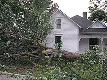
to the east of the center (although little or no rain fell in many of those areas) were as a result of a combination of factors, including the strength and size of Ike itself allowing for a strong pressure gradient and a well-defined structure, the location on the east side of the storm where the winds are usually stronger in a northward-moving system due to its forward motion, its fast forward motion of about 40 miles per hour (64.4 km/h) , and the warm air ahead of the storm allowed the high winds aloft to reach the surface easier. Many areas reported wind gusts to hurricane force.
It was one of the largest power outages caused by a natural disaster in the history of the Midwest with about 3.7 million customers losing power (well over 8 million people), including 2.6 million outages in the state of Ohio
Ohio
Ohio is a Midwestern state in the United States. The 34th largest state by area in the U.S.,it is the 7th‑most populous with over 11.5 million residents, containing several major American cities and seven metropolitan areas with populations of 500,000 or more.The state's capital is Columbus...
alone 26 people were killed in the interior states.
Arkansas

Arkansas
Arkansas is a state located in the southern region of the United States. Its name is an Algonquian name of the Quapaw Indians. Arkansas shares borders with six states , and its eastern border is largely defined by the Mississippi River...
, about 200,000 customers lost power as a result of the winds, the worst power loss in that state since an ice storm in 2000. Damage was widespread, with trees and power lines knocked down in many areas. At least five tornadoes—all rated EF1 on the Enhanced Fujita Scale
Enhanced Fujita Scale
The Enhanced Fujita Scale rates the strength of tornadoes in the United States based on the damage they cause.Implemented in place of the Fujita scale introduced in 1971 by Ted Fujita, it began operational use on February 1, 2007. The scale has the same basic design as the original Fujita scale:...
—were reported, in Garland, Hot Spring, Lonoke, Perry and Saline Counties. The Lonoke County tornado caused some structural damage near Cabot
Cabot, Arkansas
As of the census of 2000, there were 15,269 people, 5,432 households, and 4,329 families residing in the city. The population density was 798.2 people per square mile . There were 5,712 housing units at an average density of 298.8 per square mile...
, including a storage unit and several metal buildings at a lumber mill that were destroyed, a strip mall that was heavily damaged and many signs blown down. Arkansas was spared the significant rainfall that areas farther north saw though. One person was killed when a tree fell onto a mobile home near Fisher, Arkansas
Fisher, Arkansas
Fisher is a town in Poinsett County, Arkansas, United States. The population was 265 at the 2000 census. It is included in the Jonesboro, Arkansas Metropolitan Statistical Area.-Geography:Fisher is located at ....
.
Tennessee and Missouri
Two deaths occurred when a tree fell onto two people on a golf course in Hermitage, TennesseeHermitage, Tennessee
Hermitage, Tennessee is a section of Metropolitan Nashville, Tennessee located in eastern Davidson County, adjacent to, and named in honor of, The Hermitage, home of Andrew Jackson, seventh President of the United States...
, just outside Nashville
Nashville, Tennessee
Nashville is the capital of the U.S. state of Tennessee and the county seat of Davidson County. It is located on the Cumberland River in Davidson County, in the north-central part of the state. The city is a center for the health care, publishing, banking and transportation industries, and is home...
.
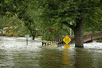
Parts of Missouri
Missouri
Missouri is a US state located in the Midwestern United States, bordered by Iowa, Illinois, Kentucky, Tennessee, Arkansas, Oklahoma, Kansas and Nebraska. With a 2010 population of 5,988,927, Missouri is the 18th most populous state in the nation and the fifth most populous in the Midwest. It...
, particularly around St. Louis
St. Louis, Missouri
St. Louis is an independent city on the eastern border of Missouri, United States. With a population of 319,294, it was the 58th-largest U.S. city at the 2010 U.S. Census. The Greater St...
, sustained major flooding. In St. Charles County, the Missouri River
Missouri River
The Missouri River flows through the central United States, and is a tributary of the Mississippi River. It is the longest river in North America and drains the third largest area, though only the thirteenth largest by discharge. The Missouri's watershed encompasses most of the American Great...
reached well above flood stage with forecasts as high as 11 feet (3.4 m) above flood stage, and seven private levees were threatened. Another hard-hit community was Arnold
Arnold, Missouri
Arnold is the largest city in Jefferson County, Missouri, United States. The population was estimated to be 20,603 in 2008, slightly more than the 19,965 number reported in the 2000 census.-Geography:Arnold is located at...
, where the Meramec River threatened to reach major flood stage for the third time in 2008, although sandbags were still up from the March flood there. The high winds in southeastern Missouri, particularly the Bootheel
Bootheel
The Missouri Bootheel is the southeasternmost part of the state of Missouri, extending south of 36°30’ north latitude, so called because its shape in relation to the rest of the state resembles the heel of a boot. Strictly speaking, it is composed of the counties of Dunklin, New Madrid, and Pemiscot...
, also blew corn stalks down and caused severe damage to crops. The winds and rain knocked out power to about 85,000 customers in Missouri.
A woman was also struck and killed by a large tree limb in Ladue, Missouri
Ladue, Missouri
Ladue is an inner-ring suburb of St. Louis, located in central St. Louis County, Missouri, USA. As of the 2010 census, the city had a population of 8,521....
, and two bodies of a man and a woman who presumably drowned were found in University City, Missouri
University City, Missouri
University City is an inner-ring suburb in St. Louis County, Missouri. The population was 35,371 in 2010 census. The city was shaped by Washington University in St. Louis, whose campus abuts the city to the southeast....
, outside of St. Louis. Another drowning took place in floodwaters in Columbia, Missouri
Columbia, Missouri
Columbia is the fifth-largest city in Missouri, and the largest city in Mid-Missouri. With a population of 108,500 as of the 2010 Census, it is the principal municipality of the Columbia Metropolitan Area, a region of 164,283 residents. The city serves as the county seat of Boone County and as the...
.
Kentucky
The LouisvilleLouisville, Kentucky
Louisville is the largest city in the U.S. state of Kentucky, and the county seat of Jefferson County. Since 2003, the city's borders have been coterminous with those of the county because of a city-county merger. The city's population at the 2010 census was 741,096...
area declared a state of emergency
State of emergency
A state of emergency is a governmental declaration that may suspend some normal functions of the executive, legislative and judicial powers, alert citizens to change their normal behaviours, or order government agencies to implement emergency preparedness plans. It can also be used as a rationale...
due to major damage, and the Louisville International Airport
Louisville International Airport
Louisville International Airport is a joint civil-military public airport centrally located in the city of Louisville in Jefferson County, Kentucky, USA. The airport covers 1,200 acres and has three runways. Its IATA airport code SDF is based on the airport's former name, Standiford Field...
was closed temporarily. A LG&E spokesperson said that this was the worst power outage in 30 years. Near Covington
Covington, Kentucky
-Demographics:As of the census of 2000, there were 43,370 people, 18,257 households, and 10,132 families residing in the city. The population density was 3,301.3 people per square mile . There were 20,448 housing units at an average density of 1,556.5 per square mile...
, the Cincinnati-Northern Kentucky International Airport was also temporarily shut down, and the control tower was evacuated. Also in Covington, an apartment building lost its entire roof and the Renaissance Hotel also sustained damage. Later in the day, a statewide state of emergency was declared in Kentucky by Governor
Governor of Kentucky
The Governor of the Commonwealth of Kentucky is the head of the executive branch of government in the U.S. state of Kentucky. Fifty-six men and one woman have served as Governor of Kentucky. The governor's term is four years in length; since 1992, incumbents have been able to seek re-election once...
Steve Beshear
Steve Beshear
Steven Lynn "Steve" Beshear is an American politician who is the 61st Governor of the Commonwealth of Kentucky. A Democrat, Beshear previously served in the Kentucky House of Representatives from 1974 to 1979, was the state's Attorney General from 1980 to 1983, and was Lieutenant Governor from...
. All school districts in the three northernmost counties in the state, except two (Southgate Independent Schools and Kenton County Schools) closed or delayed in the first 3 days following the storm.
In the Louisville area, over 300,000 customers were without power - the worst power outage in the utility's history. In western Kentucky, outside crews had to be brought in from as far away as Mississippi
Mississippi
Mississippi is a U.S. state located in the Southern United States. Jackson is the state capital and largest city. The name of the state derives from the Mississippi River, which flows along its western boundary, whose name comes from the Ojibwe word misi-ziibi...
to restore power. Statewide, well over 600,000 customers lost electricity as a result of the winds.
In Simpsonville
Simpsonville, Kentucky
Simpsonville is a city in Shelby County, Kentucky, United States. The population was 1,281 at the 2000 census and estimated at 1,482 in 2009.-Geography:Simpsonville is located at ....
, a boy was struck and killed by a blown tree limb while outdoors.
Illinois and Indiana
Illinois
Illinois is the fifth-most populous state of the United States of America, and is often noted for being a microcosm of the entire country. With Chicago in the northeast, small industrial cities and great agricultural productivity in central and northern Illinois, and natural resources like coal,...
suffered significant flooding. The hardest hit rivers were the DuPage
DuPage River
The DuPage River is a tributary of the Des Plaines River in the U.S. state of Illinois.-Course:The river begins as two individual streams. The West Branch of the DuPage River, long, starts in Schaumburg at Campanelli Park in Cook County and continues southward through the entire county of DuPage,...
, Des Plaines
Des Plaines River
The Des Plaines River is a river that flows southward for through southern Wisconsin and northern Illinois in the U.S. Midwest, eventually meeting the Kankakee River west of Channahon to form the Illinois River, a tributary of the Mississippi River....
and Chicago
Chicago River
The Chicago River is a system of rivers and canals with a combined length of that runs through the city of the same name, including its center . Though not especially long, the river is notable for being the reason why Chicago became an important location, as the link between the Great Lakes and...
Rivers. Many volunteers were called in to fill sandbags in an attempt to hold back the rising rivers. Dozens of people had to be rescued by boat. The corn
Maize
Maize known in many English-speaking countries as corn or mielie/mealie, is a grain domesticated by indigenous peoples in Mesoamerica in prehistoric times. The leafy stalk produces ears which contain seeds called kernels. Though technically a grain, maize kernels are used in cooking as a vegetable...
and soybean
Soybean
The soybean or soya bean is a species of legume native to East Asia, widely grown for its edible bean which has numerous uses...
crops were also threatened in many areas as a result of the heavy rainfall. In Riverside, several neighborhoods and much of the local forest preserve area were submerged in up to 2 to 4 feet of rapidly flowing water by the swollen Des Plaines River. A state of emergency
State of emergency
A state of emergency is a governmental declaration that may suspend some normal functions of the executive, legislative and judicial powers, alert citizens to change their normal behaviours, or order government agencies to implement emergency preparedness plans. It can also be used as a rationale...
was declared in Chicago
Chicago
Chicago is the largest city in the US state of Illinois. With nearly 2.7 million residents, it is the most populous city in the Midwestern United States and the third most populous in the US, after New York City and Los Angeles...
and Cook County
Cook County, Illinois
Cook County is a county in the U.S. state of Illinois, with its county seat in Chicago. It is the second most populous county in the United States after Los Angeles County. The county has 5,194,675 residents, which is 40.5 percent of all Illinois residents. Cook County's population is larger than...
as a result of the floodwaters. That was later extended statewide by Governor
Governor of Illinois
The Governor of Illinois is the chief executive of the State of Illinois and the various agencies and departments over which the officer has jurisdiction, as prescribed in the state constitution. It is a directly elected position, votes being cast by popular suffrage of residents of the state....
Rod Blagojevich
Rod Blagojevich
Rod R. Blagojevich is an American politician who served as the 40th Governor of Illinois from 2003 to 2009. A Democrat, Blagojevich was a State Representative before being elected to the United States House of Representatives representing parts of Chicago...
. About 49,000 customers lost power in Illinois.
The northwestern part of Indiana
Indiana
Indiana is a US state, admitted to the United States as the 19th on December 11, 1816. It is located in the Midwestern United States and Great Lakes Region. With 6,483,802 residents, the state is ranked 15th in population and 16th in population density. Indiana is ranked 38th in land area and is...
was hard hit by flooding, which was partially related to the frontal boundary and partially related to Ike. One of the hardest-hit communities was Munster
Munster, Indiana
Munster is a town located in North Township, Lake County, in Northwest Indiana in the United States. This bedroom community lies in the Chicago metropolitan area, approximately southeast of the Chicago Loop, and shares municipal boundaries with Hammond to the north, Highland to the east, Dyer and...
, where 5,000 residents had to be evacuated as a result of the Little Calumet River overflowing in many spots and breaking through the levee near the Calumet Avenue bridge. Several people had to be rescued by boat and there was a garage fire and a massive house explosion in the flooded area that leveled one house and damaged others. Parts of Interstates 80
Interstate 80
Interstate 80 is the second-longest Interstate Highway in the United States, following Interstate 90. It is a transcontinental artery running from downtown San Francisco, California to Teaneck, New Jersey in the New York City Metropolitan Area...
and 94
Interstate 94
Interstate 94 is the northernmost east–west Interstate Highway, connecting the Great Lakes and Intermountain regions of the United States. I-94's western terminus is in Billings, Montana at a junction with Interstate 90; its eastern terminus is the U.S...
were closed due to flooding, slowing traffic greatly in the region.
In Indiana, about 350,000 customers lost power statewide, mostly in the southern part. The fields of southern Indiana were heavily impacted, and a spokesman the state's Natural Resource Conservation Service described the situation as a "severe crop loss" and the "worst wind damage I have ever seen". A state of emergency was later declared by Governor
Governor of Indiana
The Governor of Indiana is the chief executive of the state of Indiana. The governor is elected to a four-year term, and responsible for overseeing the day-to-day management of the functions of many agencies of the Indiana state government. The governor also shares power with other statewide...
Mitch Daniels
Mitch Daniels
Mitchell Elias "Mitch" Daniels, Jr. is the 49th and current Governor of the U.S. state of Indiana. A Republican, he began his first four-year term as governor on January 10, 2005, and was elected to his second term by an 18-point margin on November 4, 2008. Previously, he was the Director of the...
.
Seven deaths were reported in Indiana. Two deaths took place in Chesterton
Chesterton, Indiana
Chesterton is a town in Westchester, Jackson and Liberty townships, Porter County, Indiana, United States. The population was 13,068 at the 2010 census. The three towns of Chesterton, Burns Harbor, and Porter are known as the tri-towns or the Duneland area....
as a result of flooding, and five deaths due to fallen trees in other parts of Indiana - two in Clark County
Clark County, Indiana
Clark County is a county located in the U.S. state of Indiana, located directly across the Ohio River from Louisville, Kentucky. At the 2010 Census, the population was 110,232. The county seat is Jeffersonville. Clarksville is also a major city in the county...
and one each in Crawford
Crawford County, Indiana
Crawford County is a county located in the U.S. state of Indiana. As of 2010, the population was 10,713. The county seat is English.-Geography:...
, Perry
Perry County, Indiana
Perry County is a county located in the southwestern part of the U.S. state of Indiana. As of 2010, the population was 19,338. The county seat is Tell City. It is the hilliest county as well as one of the most forested counties of in Indiana as it features more than of Hoosier National Forest...
and Ohio
Ohio County, Indiana
As of the census of 2000, there were 5,623 people, 2,201 households, and 1,586 families residing in the county. The population density was 65 people per square mile . There were 2,424 housing units at an average density of 28 per square mile...
Counties. Two deaths were reported in Illinois, both of which were drownings.
Ohio and Michigan
Ohio
Ohio is a Midwestern state in the United States. The 34th largest state by area in the U.S.,it is the 7th‑most populous with over 11.5 million residents, containing several major American cities and seven metropolitan areas with populations of 500,000 or more.The state's capital is Columbus...
was hit extremely hard by the storm. The remnants of Ike caused a total of 2.6 million power outages in the state of Ohio, including 370,000 outages in the state capital of Columbus
Columbus, Ohio
Columbus is the capital of and the largest city in the U.S. state of Ohio. The broader metropolitan area encompasses several counties and is the third largest in Ohio behind those of Cleveland and Cincinnati. Columbus is the third largest city in the American Midwest, and the fifteenth largest city...
. Many of the citizens in Columbus were without power for close to a week, because 25 percent of the AEP
American Electric Power
American Electric Power is a major investor-owner electric utility in various parts of the United States. AEP ranks among the nation's largest generators of electricity, owning nearly 38,000 megawatts of generating capacity in the U.S...
company's workers were in Texas
Texas
Texas is the second largest U.S. state by both area and population, and the largest state by area in the contiguous United States.The name, based on the Caddo word "Tejas" meaning "friends" or "allies", was applied by the Spanish to the Caddo themselves and to the region of their settlement in...
helping crews there restore electricity to the millions who lost power because of Hurricane Ike.
In Cincinnati
Cincinnati, Ohio
Cincinnati is a city in the U.S. state of Ohio. Cincinnati is the county seat of Hamilton County. Settled in 1788, the city is located to north of the Ohio River at the Ohio-Kentucky border, near Indiana. The population within city limits is 296,943 according to the 2010 census, making it Ohio's...
, the effects of this storm have become known as The Cincinnati Blackout. Wind gusts of over 75 miles per hour (120.7 km/h) were recorded in Cincinnati
Cincinnati, Ohio
Cincinnati is a city in the U.S. state of Ohio. Cincinnati is the county seat of Hamilton County. Settled in 1788, the city is located to north of the Ohio River at the Ohio-Kentucky border, near Indiana. The population within city limits is 296,943 according to the 2010 census, making it Ohio's...
, Dayton
Dayton, Ohio
Dayton is the 6th largest city in the U.S. state of Ohio and the county seat of Montgomery County, the fifth most populous county in the state. The population was 141,527 at the 2010 census. The Dayton Metropolitan Statistical Area had a population of 841,502 in the 2010 census...
and Columbus
Columbus, Ohio
Columbus is the capital of and the largest city in the U.S. state of Ohio. The broader metropolitan area encompasses several counties and is the third largest in Ohio behind those of Cleveland and Cincinnati. Columbus is the third largest city in the American Midwest, and the fifteenth largest city...
, which is equivalent to sustained wind levels found in a Category 1 hurricane. Additionally, a state of emergency was declared in Ohio
Ohio
Ohio is a Midwestern state in the United States. The 34th largest state by area in the U.S.,it is the 7th‑most populous with over 11.5 million residents, containing several major American cities and seven metropolitan areas with populations of 500,000 or more.The state's capital is Columbus...
on Monday by Governor Ted Strickland
Ted Strickland
Theodore "Ted" Strickland was the 68th Governor of Ohio, serving from 2007 to 2011. A member of the Democratic Party, he previously served in the United States House of Representatives, representing ....
. On September 16 and 17, Governor Strickland took a tour of the heavily damaged areas, particularly in Cincinnati, Columbus and Dayton
Dayton, Ohio
Dayton is the 6th largest city in the U.S. state of Ohio and the county seat of Montgomery County, the fifth most populous county in the state. The population was 141,527 at the 2010 census. The Dayton Metropolitan Statistical Area had a population of 841,502 in the 2010 census...
to survey the damage.
The Cincinnati metropolitan area was very hard hit, with over 927,000 customers losing power in that region (approximately 2.1 million people). A Duke Energy
Duke Energy
Duke Energy , headquartered in Charlotte, North Carolina, is an energy company with assets in the United States, Canada and Latin America.-Overview:...
spokesperson said “We have never seen anything like this. Never. We’re talking about 90 percent of our customers without power" On September 15, 16 and 17, most of the schools in Hamilton County
Hamilton County, Ohio
As of 2000, there were 845,303 people, 346,790 households, and 212,582 families residing in the county. The population density was 2,075 people per square mile . There were 373,393 housing units at an average density of 917 per square mile...
and Butler County
Butler County, Ohio
Butler County is a county located in the state of Ohio, United States. As of 2010, the population was 368,130. Its county seat is Hamilton. It is named for General Richard Butler, who died in 1791 fighting Indians in northern Ohio. Butler's army marched out of Fort Hamilton, where the city of...
had classes cancelled because of power outages. In the Dayton, Ohio area 300,000 of 515,000 Dayton Power & Light Co. customers lost power at some point following severe wind storms on the afternoon of September 14, according to a company spokesperson. As of Thursday morning, September 18, 90,000 DP&L customers remained without power. Also hard hit were central Ohio (with over 350,000 customers losing power) and northeastern Ohio (with over 310,000 customers losing power). A water emergency was also declared in Butler County
Butler County, Ohio
Butler County is a county located in the state of Ohio, United States. As of 2010, the population was 368,130. Its county seat is Hamilton. It is named for General Richard Butler, who died in 1791 fighting Indians in northern Ohio. Butler's army marched out of Fort Hamilton, where the city of...
as the water supply diminished due to the lack of power, and a "Level One" emergency was declared in the county to encourage people to remain at home, although stopping short of a curfew
Curfew
A curfew is an order specifying a time after which certain regulations apply. Examples:# An order by a government for certain persons to return home daily before a certain time...
. A curfew was implemented on September 17 in Carlisle
Carlisle, Ohio
Carlisle is a village located in the southwestern part of the U.S. state of Ohio in northwestern Warren and southern Montgomery counties. As of the 2010 census, the village's population was 4,915, down from 5,121 in the 2000 census. This population loss caused Carlisle to once again become a village...
due to increased looting
Looting
Looting —also referred to as sacking, plundering, despoiling, despoliation, and pillaging—is the indiscriminate taking of goods by force as part of a military or political victory, or during a catastrophe, such as during war, natural disaster, or rioting...
activity as a result of the lengthy power outage and damage.
Agricultural damage was severe, with as much as 20% of the state's total corn crop lost as a result of winds blowing down corn stalks. Some fields were nearly flattened by the hurricane-force wind gusts. Tens of thousands of people also lost power in northwest Ohio
Northwest Ohio
Northwest or northwestern Ohio consists of multiple counties in the northwestern corner of the US state of Ohio. This area borders Lake Erie, southern Michigan, and eastern Indiana. Some areas in northwestern Ohio are also considered the Black Swamp area. The Toledo metropolitan area is also part...
where widespread outages and damage were reported in the Lima
Lima, Ohio
Lima is a city in and the county seat of Allen County, Ohio, United States. The municipality is located in northwestern Ohio along Interstate 75 approximately north of Dayton and south-southwest of Toledo....
and Findlay
Findlay, Ohio
As of the census of 2000, there were 38,967 people, 15,905 households, and 10,004 families residing in the city. The population density was 2,266.3 people per square mile . There were 17,152 housing units at an average density of 997.6 per square mile...
areas as the center of the storm tracked just to the north and west. Some of the most significant damage there included a radio tower that collapsed and a church that was heavily damaged.
In Mount Healthy
Mount Healthy, Ohio
Mount Healthy is a city in Hamilton County, Ohio, United States, in the Cincinnati/Northern Kentucky metropolitan area. The population was 7,149 at the 2000 census.-Geography:Mount Healthy is located at ....
, a tree crushing a house resulted in one fatality, and two others died when a tree crashed onto a motorcycle parade in Hueston Woods State Park
Hueston Woods State Park
Hueston Woods State Park is a state park located in the Butler and Preble counties of the U.S. state of Ohio, about five miles northeast of Oxford in the southwestern part of the state. It has , including a man-made lake of . The state bought the land in 1941, but the park did not open until 1957...
near Oxford
Oxford, Ohio
Oxford is a city in northwestern Butler County, Ohio, United States, in the southwestern portion of the state. It lies in Oxford Township, originally called the College Township. The population was 21,943 at the 2000 census. This college town was founded as a home for Miami University. Oxford...
. A similar incident in Lorain County
Lorain County, Ohio
Lorain County is a county located in the U.S. state of Ohio, and is considered to be a part of what is locally referred to as Greater Cleveland. As of the 2010 census, its population was 301,356. an increase from 284,664 in 2000...
also resulted in the death of a young boy who was hit by a fallen tree limb. An indirect death in Hilliard
Hilliard, Ohio
Hilliard is a city in Franklin County, Ohio, United States. The population was 28,435 at the 2010 census.-Geography:Hilliard is located at . It is bordered on the east by Upper Arlington, on the north by Dublin, on the south by Galloway and Columbus, and to the west lies open farmland...
was caused by electrocution while working on a generator, and another in St. Bernard
St. Bernard, Ohio
St. Bernard is a small city in Hamilton County, Ohio, United States. The population was 4,924 at the 2000 census.-Geography:St. Bernard is located at , and along with Norwood and Elmwood Place, is an enclave surrounded by the city of Cincinnati.According to the United States Census Bureau, the...
was caused by a candle fire while power was out.
The southern part of Michigan sustained heavy rainfall resulting in many houses being flooded, partially due to Ike and partially due to the frontal boundary. Two deaths were reported in Michigan - both drownings, one in a ditch and one in a vehicle. Tornado warnings were also issued across Southern Michigan, for Van Buren
Van Buren County, Michigan
-Parks, preserves, natural areas:* Dunes Parkway, an 84 acre preserve of dunes in Covert Township* Jeptha Lake Fen Preserve, a 49 acre preserve in Columbia Township...
, Kalamazoo, and Calhoun
Calhoun County, Michigan
-Interstates:* I-69* I-94* I-194* I-94 Business Loop serves the city of Albion.* I-94 Business Loop serves the city of Battle Creek.* I-94 Business Loop serves the city of Marshall.-Michigan State Trunklines:* M-37* M-60* M-66* M-78* M-89* M-96* M-99...
counties.
Pennsylvania, West Virginia and New York
In total, over 180,000 customers lost power as a result of the high winds in western PennsylvaniaPennsylvania
The Commonwealth of Pennsylvania is a U.S. state that is located in the Northeastern and Mid-Atlantic regions of the United States. The state borders Delaware and Maryland to the south, West Virginia to the southwest, Ohio to the west, New York and Ontario, Canada, to the north, and New Jersey to...
. The damage eventually resulted in a state of emergency declaration by Governor Ed Rendell
Ed Rendell
Edward Gene "Ed" Rendell is an American politician who served as the 45th Governor of Pennsylvania. Rendell, a member of the Democratic Party, was elected Governor of Pennsylvania in 2002, and his term of office began January 21, 2003...
. In Oil City
Oil City, Pennsylvania
Oil City is a city in Venango County, Pennsylvania that is known in the initial exploration and development of the petroleum industry. After the first oil wells were drilled nearby in the 1850s, Oil City became central in the petroleum industry while hosting headquarters for the Pennzoil, Quaker...
, one death took place as a result of a fallen tree limb while outdoors.
The Northern Panhandle of West Virginia
Northern Panhandle of West Virginia
The Northern Panhandle is a culturally and geographically distinct region in the U.S. state of West Virginia. It is the state's northernmost extension, bounded by the Ohio River on the north and west, along with the state of Pennsylvania on the east...
also sustained high winds and hail as a result of the storm with widespread tree damage. About 32,000 customers in the region lost power, particularly around Wheeling
Wheeling, West Virginia
Wheeling is a city in Ohio and Marshall counties in the U.S. state of West Virginia; it is the county seat of Ohio County. Wheeling is the principal city of the Wheeling Metropolitan Statistical Area...
.
The high winds continued northward into Upstate New York
Upstate New York
Upstate New York is the region of the U.S. state of New York that is located north of the core of the New York metropolitan area.-Definition:There is no clear or official boundary between Upstate New York and Downstate New York...
late in the evening of September 14. Widespread damage, mostly to trees and power lines, was reported. In New York State, over 100,000 customers were reported without power. The hardest hit area was around Rochester
Rochester, New York
Rochester is a city in Monroe County, New York, south of Lake Ontario in the United States. Known as The World's Image Centre, it was also once known as The Flour City, and more recently as The Flower City...
, where over half of the outages were reported.
Canada
Ontario
Ontario is a province of Canada, located in east-central Canada. It is Canada's most populous province and second largest in total area. It is home to the nation's most populous city, Toronto, and the nation's capital, Ottawa....
, Ike's remnants brought a record amount of rain on Sunday, September 14, in the Windsor
Windsor, Ontario
Windsor is the southernmost city in Canada and is located in Southwestern Ontario at the western end of the heavily populated Quebec City – Windsor Corridor. It is within Essex County, Ontario, although administratively separated from the county government. Separated by the Detroit River, Windsor...
region. It was closely following a slow-moving frontal system that had drenched the city the day before, dumping 75.2 mm (2.96 in) of rain and breaking the old record of 39.1 mm (1.54 in) in 1979, according to Environment Canada
Environment Canada
Environment Canada , legally incorporated as the Department of the Environment under the Department of the Environment Act Environment Canada (EC) (French: Environnement Canada), legally incorporated as the Department of the Environment under the Department of the Environment Act Environment...
. Most damage in the Windsor area with Ike was confined to downed power lines and toppled tree branches with the wind gusts reaching 80 km/h (49.71 mph), with spotty street flooding that made driving completely treacherous in some areas. Highways were washed out in the Bruce Peninsula
Bruce Peninsula
The Bruce Peninsula is a peninsula in Ontario, Canada that lies between Georgian Bay and the main basin of Lake Huron. The peninsula extends roughly northwestwards from the rest of Southern Ontario, pointing towards Manitoulin Island, with which it forms the widest strait joining Georgian Bay to...
, and trees were uprooted in London, Ontario
London, Ontario
London is a city in Southwestern Ontario, Canada, situated along the Quebec City – Windsor Corridor. The city has a population of 352,395, and the metropolitan area has a population of 457,720, according to the 2006 Canadian census; the metro population in 2009 was estimated at 489,274. The city...
. The storm continued to cause wind and rain damage as it continues east along the St. Lawrence River leaving around 25,000 customers without electricity, especially in Belleville
Belleville, Ontario
Belleville is a city located at the mouth of the Moira River on the Bay of Quinte in Southern Ontario, Canada, in the Quebec City-Windsor Corridor. It is the seat of Hastings County, but is politically independent of it. and the centre of the Bay of Quinte Region...
, Brockville
Brockville, Ontario
Brockville is a city in Eastern Ontario, Canada, in the Thousand Islands region. Though it serves as the seat of the United Counties of Leeds and Grenville, Brockville is politically independent and is grouped with Leeds and Grenville for census purposes only.Known as the "City of the 1000...
, Bancroft
Bancroft, Ontario
Bancroft is a town located on the York River in Hastings County in the Canadian province of Ontario.- History :In 1853 the first pioneer family settled in the area, and over the next 15 years the settlement grew quickly, as another 88 families followed...
, Peterborough
Peterborough, Ontario
Peterborough is a city on the Otonabee River in southern Ontario, Canada, 125 kilometres northeast of Toronto. The population of the City of Peterborough was 74,898 as of the 2006 census, while the census metropolitan area has a population of 121,428 as of a 2009 estimate. It presently ranks...
, Bowmanville, Huntsville
Huntsville, Ontario
Huntsville is a town in the Muskoka Region of Ontario, Canada. It is located north of Toronto and south of North Bay....
and Timmins
Timmins, Ontario
Timmins is a city in northeastern Ontario, Canada on the Mattagami River. At the time of the Canada 2006 Census, Timmins' population was 42,997...
.
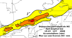
In Quebec
Quebec
Quebec or is a province in east-central Canada. It is the only Canadian province with a predominantly French-speaking population and the only one whose sole official language is French at the provincial level....
province, regions to the north of the Saint Lawrence River
Saint Lawrence River
The Saint Lawrence is a large river flowing approximately from southwest to northeast in the middle latitudes of North America, connecting the Great Lakes with the Atlantic Ocean. It is the primary drainage conveyor of the Great Lakes Basin...
received 50 mm (1.97 in) to 70 mm (2.76 in) of rainfall (Hautes-Laurentides
Laurentides (region)
The Laurentides is a region of Quebec. While it is often called the Laurentians in English, the region includes only part of the Laurentian mountains...
, Haute-Mauricie
Mauricie
Mauricie is a traditional and current administrative region of Quebec. La Mauricie National Park is contained within the region, making it a prime tourist location. The region has a land area of 35,855.22 km² and a 2006 census population of 258,928 residents...
, Réserve faunique des Laurentides
Jacques-Cartier River
The Jacques-Cartier River is a river in the province of Quebec, Canada. It is 161 km long and its source is Jacques-Cartier Lake in Laurentides Wildlife Reserve, and flows in a predominantly southern direction before ending in the Saint Lawrence River at Donnacona, about 30 km upstream...
, Saguenay-Lac-Saint-Jean
Saguenay-Lac-Saint-Jean
Saguenay–Lac-Saint-Jean is a region in Quebec, Canada. It contains the Saguenay Fjord, the estuary of the Saguenay River, stretching through much of the region...
, Charlevoix
Charlevoix
The Charlevoix region, located in Quebec, includes parts of the north shore of the Saint Lawrence River and the Laurentian Mountains region of the Canadian Shield...
and Côte-Nord
Côte-Nord
Côte-Nord is the second largest administrative region by land area in Quebec, Canada, after Nord-du-Québec...
). Maximum rainfall was recorded between Lac-St-Jean and the Réserve faunique des Laurentides with a station recording more than 90 mm (3.54 in) of rain Along the river, the amount were more in the 10 mm (0.393700787401575 in) and 30 mm (1.18 in) range, except in Quebec City
Quebec City
Quebec , also Québec, Quebec City or Québec City is the capital of the Canadian province of Quebec and is located within the Capitale-Nationale region. It is the second most populous city in Quebec after Montreal, which is about to the southwest...
area which received almost 50 mm (1.97 in) , most of it between 7:00 p.m. and 8:00 p.m. This rain caused small inundations, storm drain
Storm drain
A storm drain, storm sewer , stormwater drain or drainage well system or simply a drain or drain system is designed to drain excess rain and ground water from paved streets, parking lots, sidewalks, and roofs. Storm drains vary in design from small residential dry wells to large municipal systems...
overflows, and caused one major highway to close. In Montreal
Montreal
Montreal is a city in Canada. It is the largest city in the province of Quebec, the second-largest city in Canada and the seventh largest in North America...
, high humidity levels pushed by the system caused electrical malfunction one of the lines of the subway
Montreal Metro
The Montreal Metro is a rubber-tired metro system, and the main form of public transportation underground in the city of Montreal, Quebec, Canada....
, stranding commuters. High winds up to 78 km/h (48.47 mph) caused, at their worst, over 25,000 households to lose electricity in Montreal
Montreal
Montreal is a city in Canada. It is the largest city in the province of Quebec, the second-largest city in Canada and the seventh largest in North America...
, Laval
Laval, Quebec
Laval is a Canadian city and a region in southwestern Quebec. It is the largest suburb of Montreal, the third largest municipality in the province of Quebec, and the 14th largest city in Canada with a population of 368,709 in 2006...
, Estrie
Estrie
The Estrie is an administrative region of Quebec that overlaps mostly the Eastern Townships. Estrie, a French neologism, was coined as a derivative of est, "east."...
and Montérégie
Montérégie
Montérégie is an administrative region in southwest Québec. It includes the cities of Boucherville, Brossard, Granby, Longueuil, Salaberry-de-Valleyfield, Saint-Jean-sur-Richelieu, Saint-Hyacinthe, Sorel-Tracy, and Vaudreuil-Dorion....
and when it reached the Magdalen Islands
Magdalen Islands
The Magdalen Islands form a small archipelago in the Gulf of Saint Lawrence with a land area of . Though closer to Prince Edward Island and Nova Scotia, the islands form part of the Canadian province of Quebec....
, it had enough strength to cause a sail boat, the Océan, to sink. Its six passengers were rescued by a helicopter of the Canadian Coast Guard
Canadian Coast Guard
The Canadian Coast Guard is the coast guard of Canada. It is a federal agency responsible for providing maritime search and rescue , aids to navigation, marine pollution response, marine radio, and icebreaking...
.
The "Ike Spike" in gasoline prices was quite severe in Canada, with gas prices rising anywhere from 15 to 20 cents per liter.
External links
- Special section from WCPO