
Cyclone Hondo
Encyclopedia
Intense Tropical Cyclone Hondo (JTWC
designation:16S) was the strongest and longest lived tropical cyclone
to develop during the 2007–08 South-West Indian Ocean cyclone season. The third tropical cyclone and first intense tropical cyclone of the season, Hondo developed out of a tropical disturbance in early February about 1,020 km (635 mi) east-southeast of Diego Garcia
. The disturbance quickly strengthened, becoming a moderate tropical storm on February 4 and a severe tropical storm the following day. After a brief period of slower intensification, Hondo rapidly intensified
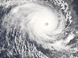
into an intense tropical cyclone and reached its peak intensity with winds of 215 km/h (130 mph 10-minute winds) on February 7. The cyclone gradually weakened over the next several days due to an increase in forward speed and a decrease in sea surface temperatures. On February 12, Hondo rapidly degenerated into a remnant-low pressure area. Over the following week, the remnant low traveled in a general west-northwest direction with no development. On February 20, about 2,780 km (1,725 mi) northeast of where the final advisories were issued, the storm began to regenerate. The next day, advisories were issued on Tropical Disturbance Ex-Hondo, which briefly strengthened into a tropical depression. However, according to the Joint Typhoon Warning Center, Hondo continued to strengthen and attained winds of 95 km/h (60 mph 1-minute winds) before passing directly over Réunion
. Interaction with the island caused the storm to weaken and degenerate into a remnant low once more. The storm dissipated on February 29 after executing a counterclockwise loop.
for the southwest Indian Ocean, Météo-France
, and the Joint Typhoon Warning Center
(JTWC) began monitoring a tropical disturbance located in the western portion of Météo-France's area of responsibility. However, it was not operationally classified as a disturbance for another two days. Traveling generally towards the southwest, the disturbance slowly strengthened. At 0300 UTC
on February 4, the JTWC issued a Tropical Cyclone Formation Alert
for the system as deep convection
and outer bands
developed around the center. Located within a narrow area of low to moderate wind shear
, the system traveled towards the west-southwest at 15 km/h (9 mph). Shortly after, Météo-France began issuing advisories on Tropical Disturbance 10 while it was located about 1,020 km (635 mi) east-southeast of Diego Garcia
. A buoy located just to the south of the small circulation recording decreasing atmospheric pressure
, having lowered by 4 hPa
(mbar
) in the past 24 hours.
With weak steering currents provided by an area of high pressure
to the north, the disturbance slowly moved towards the east-southeast. At 1500 UTC, the JTWC began issuing advisories on the disturbance which they designated as Tropical Cyclone 16S. With high oceanic heat content
, low wind shear, and good divergence aloft, significant strengthening was likely. Early the next day, Météo-France upgraded the disturbance to a tropical depression as winds increased to 55 km/h (35 mph 10-minute winds). However, in the post-season analysis, Météo-France determined that the system had become a depression about 12 hours earlier and was already a moderate tropical storm by the time of the operation upgrade. At 0600 UTC, Météo-France classified the depression as a moderate tropical storm and was given the name Hondo; a name submitted to the World Meteorological Organization
by Zimbabwe
. It was later determined that Hondo was already a severe tropical storm by the time it was named operationally.
Hondo continued to quickly strengthen, becoming a tropical cyclone, the equivalent of a Category 1 hurricane on the Saffir-Simpson Hurricane Scale
, that same day. After maintaining its through the early hours of February 6, a pinhole eye
began to develop, signifying that Hondo was beginning to undergo rapid intensification
. During this intensification phase, the storm became nearly stationary again due to a weakness in the ridge which was previously steering the cyclone towards the east. Later that day, Hondo was upgraded to an intense tropical cyclone with winds of 175 km/h (110 mph 10-minute winds). After becoming an intense tropical cyclone, wind shear began to increase, causing the eye to become slightly disorganized, temporarily slowed the intensification. Later in the day, the eye became better defined, allowing Hondo to intensify further. Operationally, Hondo was upgraded to a very intense tropical cyclone with winds of 220 km/h (140 mph 10-minute winds) with a minimum pressure of 906 hPa (mbar). However, after reanalysis, it was found that Hondo never intensified beyond intense tropical cyclone status and winds peaked at 215 km/h (130 mph 10-minute winds) with a minimum pressure of 915 hPa (mbar).
Around the same time that Météo-France assessed Hondo to have peaked, the JTWC reported that the storm had attained winds of 230 km/h (145 mph 1-minute winds), equivalent to a strong Category 4 hurricane. Shortly after reaching peak intensity, the cloud tops around the eye began to warm, meaning that the storm was beginning to weaken. Hondo also turned towards the southwest and kept a steady pace as two subtropical
highs began influencing its movement. The storm continued to weaken as cloud tops warmed but remained an intense tropical cyclone as its eye was still well-defined. Hondo briefly re-intensified later on February 8 despite the structure of the storm deteriorating. The cyclone maintained intense tropical cyclone status through February 10 due to the formation of a large eye which helped maintain the storms structure. Hondo gradually began to weaken due to a combination of decreasing sea surface temperatures and increasing forward motion. On February 10, Hondo started a gradual curving path due to a trough
located to the south and strengthening high pressure systems to the north. At 0600 UTC, the storm was downgraded to a tropical cyclone as winds decreased to 155 km/h (100 mph).
Continued weakened led to the storm being downgraded to a severe tropical storm early on February 11 as it tracked towards the southeast. After spending several hours over cold waters, most of the convection associated with Hondo dissipated due to the lack of energy and the storm was further downgraded to a moderate tropical storm. Later that day, no convection remained around the storm as it weakened to a tropical depression. The JTWC issued their final advisory on February 12 as the storm showed no signs of convective activity. Hondo degenerated into a remnant-low pressure area as Météo-France issued their final advisory at 1200 UTC. For the next week, the remnant low traveled in a general west-northwestward direction with little or no development. On February 20, about 2,780 km (1,725 mi) northeast of where the final advisories were issued, the low began to develop weak convection around the northern edge of the center of circulation.
On February 21, Météo-France began to issue advisories on Tropical Disturbance Ex-Hondo which presented a well-defined circulation. Later that day, deep convection redeveloped around the center as the low entered an area favorable for development. At 0830 UTC, the JTWC issued a Tropical Cyclone Formation Alert, stating that Hondo was likely to regenerate into a tropical cyclone. Later that day, Hondo became almost stationary and was upgraded to a tropical depression as it continued to develop. The next day, Hondo was downgraded to a tropical disturbance as wind shear constrained convective development and caused the system to weaken. However, early on February 23, the JTWC began issuing advisories on Hondo as they estimated winds to have reached 65 km/h (40 mph) once more. At 0600 UTC, Hondo attained winds of 95 km/h (60 mph 1-minute winds) near Mauritius
and Réunion
. Due to the proximity to the islands, convection associated with the storm became disorganized and it began to weaken. The JTWC issued their final advisory early on February 24 as the system significantly weakened, with the center devoid of convection. Météo-France issued their final advisory several hours later. The remnants of Hondo persisted for another five days, executing a counterclockwise loop before dissipating on February 29.
and Réunion
were placed under a state of alert. Residents in Réunion were advised to stay up to date with the latest warnings on the storm, not go hiking in the mountains, ensure their disaster kit is fully stocked, stay away from the shore, and know the locations of the nearest shelters. Initially, residents in Madagascar
feared that Hondo would make landfall in the country after being struck by Cyclone Ivan
on February 16. However, the storm turn towards the southwest, away from Madagascar. On February 23 ex-Hondo tracked just offshore Mauritius before passing directly over Réunion, just short of moderate tropical storm status. Sustained winds of 50 km/h (31 mph) with gusts up to 76 km/h (47 mph) were recorded on Mauritius while sustained winds of 55 km/h (35 mph) with gusts up to 99 km/h (61 mph) were recorded on Réunion. The highest rainfall total was recorded at Takamaka, totaling to 750 mm (29.5 in). Up to 760,000 people were affected on Réunion and overall damage was minimal.
Joint Typhoon Warning Center
The Joint Typhoon Warning Center is a joint United States Navy – United States Air Force task force located at the Naval Maritime Forecast Center in Pearl Harbor, Hawaii...
designation:16S) was the strongest and longest lived tropical cyclone
Tropical cyclone
A tropical cyclone is a storm system characterized by a large low-pressure center and numerous thunderstorms that produce strong winds and heavy rain. Tropical cyclones strengthen when water evaporated from the ocean is released as the saturated air rises, resulting in condensation of water vapor...
to develop during the 2007–08 South-West Indian Ocean cyclone season. The third tropical cyclone and first intense tropical cyclone of the season, Hondo developed out of a tropical disturbance in early February about 1,020 km (635 mi) east-southeast of Diego Garcia
Diego Garcia
Diego Garcia is a tropical, footprint-shaped coral atoll located south of the equator in the central Indian Ocean at 7 degrees, 26 minutes south latitude. It is part of the British Indian Ocean Territory [BIOT] and is positioned at 72°23' east longitude....
. The disturbance quickly strengthened, becoming a moderate tropical storm on February 4 and a severe tropical storm the following day. After a brief period of slower intensification, Hondo rapidly intensified
Rapid deepening
Rapid deepening, also known as rapid intensification, is a meteorological condition that occurs when the minimum sea-level atmospheric pressure of a tropical cyclone decreases drastically in a short period of time. The National Weather Service describes rapid deepening as a decrease of...
into an intense tropical cyclone and reached its peak intensity with winds of 215 km/h (130 mph 10-minute winds) on February 7. The cyclone gradually weakened over the next several days due to an increase in forward speed and a decrease in sea surface temperatures. On February 12, Hondo rapidly degenerated into a remnant-low pressure area. Over the following week, the remnant low traveled in a general west-northwest direction with no development. On February 20, about 2,780 km (1,725 mi) northeast of where the final advisories were issued, the storm began to regenerate. The next day, advisories were issued on Tropical Disturbance Ex-Hondo, which briefly strengthened into a tropical depression. However, according to the Joint Typhoon Warning Center, Hondo continued to strengthen and attained winds of 95 km/h (60 mph 1-minute winds) before passing directly over Réunion
Réunion
Réunion is a French island with a population of about 800,000 located in the Indian Ocean, east of Madagascar, about south west of Mauritius, the nearest island.Administratively, Réunion is one of the overseas departments of France...
. Interaction with the island caused the storm to weaken and degenerate into a remnant low once more. The storm dissipated on February 29 after executing a counterclockwise loop.
Meteorological history
On February 2, the Regional Specialized Meteorological CentreRegional Specialized Meteorological Centre
A Regional Specialized Meteorological Centre is responsible for the distribution of information, advisories, and warnings regarding the specific program they have a part of, agreed by consensus at the World Meteorological Organization as part of the World Weather Watch.-Tropical...
for the southwest Indian Ocean, Météo-France
Météo-France
Météo-France is the French national meteorological service.The organisation was established by decree in June 1993 and is a department of the Ministry of Transportation. It is headquartered in Paris but many domestic operations have been decentralised to Toulouse...
, and the Joint Typhoon Warning Center
Joint Typhoon Warning Center
The Joint Typhoon Warning Center is a joint United States Navy – United States Air Force task force located at the Naval Maritime Forecast Center in Pearl Harbor, Hawaii...
(JTWC) began monitoring a tropical disturbance located in the western portion of Météo-France's area of responsibility. However, it was not operationally classified as a disturbance for another two days. Traveling generally towards the southwest, the disturbance slowly strengthened. At 0300 UTC
Coordinated Universal Time
Coordinated Universal Time is the primary time standard by which the world regulates clocks and time. It is one of several closely related successors to Greenwich Mean Time. Computer servers, online services and other entities that rely on having a universally accepted time use UTC for that purpose...
on February 4, the JTWC issued a Tropical Cyclone Formation Alert
Tropical Cyclone Formation Alert
A Tropical Cyclone Formation Alert is a bulletin released by the U.S. Navy-operated Joint Typhoon Warning Center in Honolulu, Hawaii or the Naval Maritime Forecast Center in Norfolk, Virginia, warning of the possibility of a tropical cyclone forming from a tropical disturbance that has been...
for the system as deep convection
Atmospheric convection
Atmospheric convection is the result of a parcel-environment instability, or temperature difference, layer in the atmosphere. Different lapse rates within dry and moist air lead to instability. Mixing of air during the day which expands the height of the planetary boundary layer leads to...
and outer bands
Rainband
A rainband is a cloud and precipitation structure associated with an area of rainfall which is significantly elongated. Rainbands can be stratiform or convective, and are generated by differences in temperature. When noted on weather radar imagery, this precipitation elongation is referred to as...
developed around the center. Located within a narrow area of low to moderate wind shear
Wind shear
Wind shear, sometimes referred to as windshear or wind gradient, is a difference in wind speed and direction over a relatively short distance in the atmosphere...
, the system traveled towards the west-southwest at 15 km/h (9 mph). Shortly after, Météo-France began issuing advisories on Tropical Disturbance 10 while it was located about 1,020 km (635 mi) east-southeast of Diego Garcia
Diego Garcia
Diego Garcia is a tropical, footprint-shaped coral atoll located south of the equator in the central Indian Ocean at 7 degrees, 26 minutes south latitude. It is part of the British Indian Ocean Territory [BIOT] and is positioned at 72°23' east longitude....
. A buoy located just to the south of the small circulation recording decreasing atmospheric pressure
Atmospheric pressure
Atmospheric pressure is the force per unit area exerted into a surface by the weight of air above that surface in the atmosphere of Earth . In most circumstances atmospheric pressure is closely approximated by the hydrostatic pressure caused by the weight of air above the measurement point...
, having lowered by 4 hPa
Pascal (unit)
The pascal is the SI derived unit of pressure, internal pressure, stress, Young's modulus and tensile strength, named after the French mathematician, physicist, inventor, writer, and philosopher Blaise Pascal. It is a measure of force per unit area, defined as one newton per square metre...
(mbar
Bar (unit)
The bar is a unit of pressure equal to 100 kilopascals, and roughly equal to the atmospheric pressure on Earth at sea level. Other units derived from the bar are the megabar , kilobar , decibar , centibar , and millibar...
) in the past 24 hours.
With weak steering currents provided by an area of high pressure
High pressure area
A high-pressure area is a region where the atmospheric pressure at the surface of the planet is greater than its surrounding environment. Winds within high-pressure areas flow outward due to the higher density air near their center and friction with land...
to the north, the disturbance slowly moved towards the east-southeast. At 1500 UTC, the JTWC began issuing advisories on the disturbance which they designated as Tropical Cyclone 16S. With high oceanic heat content
Sea surface temperature
Sea surface temperature is the water temperature close to the oceans surface. The exact meaning of surface varies according to the measurement method used, but it is between and below the sea surface. Air masses in the Earth's atmosphere are highly modified by sea surface temperatures within a...
, low wind shear, and good divergence aloft, significant strengthening was likely. Early the next day, Météo-France upgraded the disturbance to a tropical depression as winds increased to 55 km/h (35 mph 10-minute winds). However, in the post-season analysis, Météo-France determined that the system had become a depression about 12 hours earlier and was already a moderate tropical storm by the time of the operation upgrade. At 0600 UTC, Météo-France classified the depression as a moderate tropical storm and was given the name Hondo; a name submitted to the World Meteorological Organization
World Meteorological Organization
The World Meteorological Organization is an intergovernmental organization with a membership of 189 Member States and Territories. It originated from the International Meteorological Organization , which was founded in 1873...
by Zimbabwe
Zimbabwe
Zimbabwe is a landlocked country located in the southern part of the African continent, between the Zambezi and Limpopo rivers. It is bordered by South Africa to the south, Botswana to the southwest, Zambia and a tip of Namibia to the northwest and Mozambique to the east. Zimbabwe has three...
. It was later determined that Hondo was already a severe tropical storm by the time it was named operationally.
Hondo continued to quickly strengthen, becoming a tropical cyclone, the equivalent of a Category 1 hurricane on the Saffir-Simpson Hurricane Scale
Saffir-Simpson Hurricane Scale
The Saffir–Simpson Hurricane Scale , or the Saffir–Simpson Hurricane Wind Scale , classifies hurricanes — Western Hemisphere tropical cyclones that exceed the intensities of tropical depressions and tropical storms — into five categories distinguished by the intensities of their sustained winds...
, that same day. After maintaining its through the early hours of February 6, a pinhole eye
Eye (cyclone)
The eye is a region of mostly calm weather found at the center of strong tropical cyclones. The eye of a storm is a roughly circular area and typically 30–65 km in diameter. It is surrounded by the eyewall, a ring of towering thunderstorms where the second most severe weather of a cyclone...
began to develop, signifying that Hondo was beginning to undergo rapid intensification
Rapid deepening
Rapid deepening, also known as rapid intensification, is a meteorological condition that occurs when the minimum sea-level atmospheric pressure of a tropical cyclone decreases drastically in a short period of time. The National Weather Service describes rapid deepening as a decrease of...
. During this intensification phase, the storm became nearly stationary again due to a weakness in the ridge which was previously steering the cyclone towards the east. Later that day, Hondo was upgraded to an intense tropical cyclone with winds of 175 km/h (110 mph 10-minute winds). After becoming an intense tropical cyclone, wind shear began to increase, causing the eye to become slightly disorganized, temporarily slowed the intensification. Later in the day, the eye became better defined, allowing Hondo to intensify further. Operationally, Hondo was upgraded to a very intense tropical cyclone with winds of 220 km/h (140 mph 10-minute winds) with a minimum pressure of 906 hPa (mbar). However, after reanalysis, it was found that Hondo never intensified beyond intense tropical cyclone status and winds peaked at 215 km/h (130 mph 10-minute winds) with a minimum pressure of 915 hPa (mbar).
Around the same time that Météo-France assessed Hondo to have peaked, the JTWC reported that the storm had attained winds of 230 km/h (145 mph 1-minute winds), equivalent to a strong Category 4 hurricane. Shortly after reaching peak intensity, the cloud tops around the eye began to warm, meaning that the storm was beginning to weaken. Hondo also turned towards the southwest and kept a steady pace as two subtropical
Subtropical cyclone
A subtropical cyclone is a weather system that has some characteristics of a tropical and an extratropical cyclone. As early as the 1950s, meteorologists were unclear whether they should be characterized as tropical or extratropical cyclones. They were officially recognized by the National...
highs began influencing its movement. The storm continued to weaken as cloud tops warmed but remained an intense tropical cyclone as its eye was still well-defined. Hondo briefly re-intensified later on February 8 despite the structure of the storm deteriorating. The cyclone maintained intense tropical cyclone status through February 10 due to the formation of a large eye which helped maintain the storms structure. Hondo gradually began to weaken due to a combination of decreasing sea surface temperatures and increasing forward motion. On February 10, Hondo started a gradual curving path due to a trough
Trough (meteorology)
A trough is an elongated region of relatively low atmospheric pressure, often associated with fronts.Unlike fronts, there is not a universal symbol for a trough on a weather chart. The weather charts in some countries or regions mark troughs by a line. In the United States, a trough may be marked...
located to the south and strengthening high pressure systems to the north. At 0600 UTC, the storm was downgraded to a tropical cyclone as winds decreased to 155 km/h (100 mph).
Continued weakened led to the storm being downgraded to a severe tropical storm early on February 11 as it tracked towards the southeast. After spending several hours over cold waters, most of the convection associated with Hondo dissipated due to the lack of energy and the storm was further downgraded to a moderate tropical storm. Later that day, no convection remained around the storm as it weakened to a tropical depression. The JTWC issued their final advisory on February 12 as the storm showed no signs of convective activity. Hondo degenerated into a remnant-low pressure area as Météo-France issued their final advisory at 1200 UTC. For the next week, the remnant low traveled in a general west-northwestward direction with little or no development. On February 20, about 2,780 km (1,725 mi) northeast of where the final advisories were issued, the low began to develop weak convection around the northern edge of the center of circulation.
On February 21, Météo-France began to issue advisories on Tropical Disturbance Ex-Hondo which presented a well-defined circulation. Later that day, deep convection redeveloped around the center as the low entered an area favorable for development. At 0830 UTC, the JTWC issued a Tropical Cyclone Formation Alert, stating that Hondo was likely to regenerate into a tropical cyclone. Later that day, Hondo became almost stationary and was upgraded to a tropical depression as it continued to develop. The next day, Hondo was downgraded to a tropical disturbance as wind shear constrained convective development and caused the system to weaken. However, early on February 23, the JTWC began issuing advisories on Hondo as they estimated winds to have reached 65 km/h (40 mph) once more. At 0600 UTC, Hondo attained winds of 95 km/h (60 mph 1-minute winds) near Mauritius
Mauritius
Mauritius , officially the Republic of Mauritius is an island nation off the southeast coast of the African continent in the southwest Indian Ocean, about east of Madagascar...
and Réunion
Réunion
Réunion is a French island with a population of about 800,000 located in the Indian Ocean, east of Madagascar, about south west of Mauritius, the nearest island.Administratively, Réunion is one of the overseas departments of France...
. Due to the proximity to the islands, convection associated with the storm became disorganized and it began to weaken. The JTWC issued their final advisory early on February 24 as the system significantly weakened, with the center devoid of convection. Météo-France issued their final advisory several hours later. The remnants of Hondo persisted for another five days, executing a counterclockwise loop before dissipating on February 29.
Preparations and impact
As Hondo began to regenerate, MauritiusMauritius
Mauritius , officially the Republic of Mauritius is an island nation off the southeast coast of the African continent in the southwest Indian Ocean, about east of Madagascar...
and Réunion
Réunion
Réunion is a French island with a population of about 800,000 located in the Indian Ocean, east of Madagascar, about south west of Mauritius, the nearest island.Administratively, Réunion is one of the overseas departments of France...
were placed under a state of alert. Residents in Réunion were advised to stay up to date with the latest warnings on the storm, not go hiking in the mountains, ensure their disaster kit is fully stocked, stay away from the shore, and know the locations of the nearest shelters. Initially, residents in Madagascar
Madagascar
The Republic of Madagascar is an island country located in the Indian Ocean off the southeastern coast of Africa...
feared that Hondo would make landfall in the country after being struck by Cyclone Ivan
Cyclone Ivan
Cyclone Ivan was a powerful tropical cyclone that struck Madagascar in February 2008. Forming from a persistent area of convection on February 7, Ivan initially tracked southeastward, before looping to the west-southwest. Encountering favourable conditions, it strengthened to attain peak winds on...
on February 16. However, the storm turn towards the southwest, away from Madagascar. On February 23 ex-Hondo tracked just offshore Mauritius before passing directly over Réunion, just short of moderate tropical storm status. Sustained winds of 50 km/h (31 mph) with gusts up to 76 km/h (47 mph) were recorded on Mauritius while sustained winds of 55 km/h (35 mph) with gusts up to 99 km/h (61 mph) were recorded on Réunion. The highest rainfall total was recorded at Takamaka, totaling to 750 mm (29.5 in). Up to 760,000 people were affected on Réunion and overall damage was minimal.
See also
- 2007–08 South-West Indian Ocean cyclone season
- Timeline of the 2007–08 South-West Indian Ocean cyclone season