
Cyclone Ivan
Encyclopedia
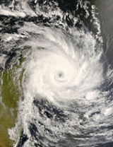
Cyclone Ivan was a powerful tropical cyclone
that struck Madagascar
in February 2008. Forming from a persistent area of convection
on February 7, Ivan initially tracked southeastward, before looping to the west-southwest. Encountering favourable conditions, it strengthened to attain peak winds on February 17 before striking northeastern Madagascar. It degenerated into a remnant low pressure area as it crossed the island, and briefly re-organized into a weak tropical depression before dissipating on February 22.
Ivan caused heavy damage in Madagascar, leaving severe flooding and wind damage. In Sainte Marie Island, the worst hit area, 90% of the infastructure was destroyed, and 70% of the structures were destroyed. On mainland Madegascar, over 400000 acres (1,618.7 km²) of cultivated crop
s were destroyed, leaving hundreds of families without food. In addition, severe flooding and high winds in Toamasina left the entire city without electricity or drinkable water. In all, over 330,000 people were left homeless, and the storm caused 93 deaths.
persisted about 555 km (900 mi) north of Réunion
in the southwest Indian Ocean
. The system maintained a broad low-level circulation with associated deep convection, and it slowly developed banding features. By early on February 7, the circulation had become better defined as it remained in an area of weak wind shear
and strong diffluence
. At 0600 UTC
, Météo-France
(MFR) classified it as Tropical Depression Eleven about 880 km (550 mi) north-northeast of Mauritus. Around the same time, the Joint Typhoon Warning Center
(JTWC) began issuing advisories on the system as Tropical Cyclone 18S. The depression tracked east-southeastward, under the influence of a mid-level ridge
. A cutoff low
to the south of the system enhanced upper-level conditions, and it quickly strengthened into Tropical Storm Ivan.
The storm rapidly organized and developed an eye
feature. Its intensification rate slowed as an upper-level trough
began restricting outflow
, and the motion of Ivan became nearly stationary as it entered an area of weak steering currents. With its overall environment remaining favourable, the JTWC upgraded Ivan to tropical cyclone status – winds greater than 119 km/h (74 mph) – early on February 9. However, the MFR retained Ivan as a strong tropical storm. Late on February 9, the storm temporarily weakened when wind shear increased, though the next day it re-intensified as convection increased; a banding eye formed in the center of the convection, prompting the JTWC to re-upgrade Ivan to tropical cyclone status late on February 10. On February 11, the MFR upgraded Ivan to tropical cyclone status 1025 km (640 mi) northeast of Mauritus.
By February 14, it had sped up and entered a more favourable environment, becoming a severe tropical storm. On February 15, Ivan was re-upgraded to a tropical cyclone as favourable conditions persisted. Ivan was further upgraded to an Intense Tropical Cyclone on February 16 as it moved closer to Madagascar
. Ivan made landfall north of Fanoarivo, Madagascar on February 17. Once overland, rapid weakening occurred due to the rugged terrain of the island. Ivan was forecast to regenerate over the Mozambique Channel
into a tropical depression once it left Madagascar. Ivan traversed Madagascar, heading southwest. Its remnants emerged back over water on February 21, and Météo-France resumed advisories on "filling depression Ex-Ivan". Ivan, severely disrupted by Madagascar, did not strengthen any further; the last advisory was issued on February 22.
near the city of Toamasina
on February 17, producing winds of 125 mph (200 km/h). According to local news agencies, Sainte Marie island off the coast of Madagascar was the highest affected area, with 9 people where killed and 90 % of the island's infrastructure destroyed, including a hotel
which collapsed. On the island, all flights were suspended or canceled during the storm, and most areas were left without electric power. Also, 75 percent of the structure
s on the island were completely destroyed.
On mainland Madagascar, 100000 acres (404.7 km²) of rice
crops were destroyed, and 300000 acres (1,214.1 km²) of other cultivated crops were destroyed. Because of this, many families had little or no food to eat. In Analanjirofo, the worst hit region on the mainland Madagascar, 80,000 people were left homeless, and most of the schools, houses and other structures were lost as a result of the flooding and high wind. Another major aspect of the damage there was the Antaratasy bridge
, a connector between the region of Atsinanana and cities to the north, which was completely destroyed, isolating several people from their families. Its collapse, in addition to the extensive damage to communications, made it difficult or impossible to contact people who may have been affected by Ivan.
In the city of Toamasina, all water and electricity were cut off as a result of the storm. High winds downed trees and power lines, and rising flood waters were the focus of concern. In the city and surrounding areas, 31 cases of cholera were reported along the Zambeze river valley as a result of the storm.
In the region of Alaotra Mangoro Region, almost 23,000 people were in need of assistance, and flooding caused extensive damage. In the Analamanga Region, 18,000 people were reported to be left without shelter, and in the Atsinanana Region, up to 13,000 people were left homeless. In total, 190,000 people were homeless as a result of the cyclone and a total of 93 fatalities occurred.
. The U.S. Agency for International Development also provided 320 rolls of plastic sheeting valued at $213,100 (2008 USD), which provided shelter assistance to 3,000 affected families, and they provided an additional $100,000 (2008 USD) to CARE and the U.N. World Food Program to re-establish ground access to affected areas, and deliver emergency supplies and food aid. This brought the total U.S. Government's assistance to Madagascar following the cyclone to more than $300,000.
Almost 140 volunteers were provided by Malagasy Red Cross in seven districts in the eastern part of the country to help in relief aid. The Malagasy Red Cross received extra supplies from the French
Red Cross which mobilized its intervention platform in the Indian Ocean to provide logistical support. Twelve tonnes of material was provided from the main center on La Reunion Island, including tarpaulins, tool kits, generators, water tablets and other emergency supplies. Also, the Malagasy president made a donation of 8 millions of ariary to local branches of the Malagasy Red Cross along with 20 tonnes of rice. As a result of this, the Red Cross was able to distribute emergency items to 1,207 families; each family received 16 kilograms (35 pounds
) of rice, 500 grams (17 ounce
s) of salt, 1.5 litres (50 fluid ounce
s) of oil, two bars of soap, candles and a lighter.
Tropical cyclone
A tropical cyclone is a storm system characterized by a large low-pressure center and numerous thunderstorms that produce strong winds and heavy rain. Tropical cyclones strengthen when water evaporated from the ocean is released as the saturated air rises, resulting in condensation of water vapor...
that struck Madagascar
Madagascar
The Republic of Madagascar is an island country located in the Indian Ocean off the southeastern coast of Africa...
in February 2008. Forming from a persistent area of convection
Convection
Convection is the movement of molecules within fluids and rheids. It cannot take place in solids, since neither bulk current flows nor significant diffusion can take place in solids....
on February 7, Ivan initially tracked southeastward, before looping to the west-southwest. Encountering favourable conditions, it strengthened to attain peak winds on February 17 before striking northeastern Madagascar. It degenerated into a remnant low pressure area as it crossed the island, and briefly re-organized into a weak tropical depression before dissipating on February 22.
Ivan caused heavy damage in Madagascar, leaving severe flooding and wind damage. In Sainte Marie Island, the worst hit area, 90% of the infastructure was destroyed, and 70% of the structures were destroyed. On mainland Madegascar, over 400000 acres (1,618.7 km²) of cultivated crop
Crop
Crop may refer to:* Crop, a plant grown and harvested for agricultural use* Crop , part of the alimentary tract of some animals* Crop , a modified whip used in horseback riding or disciplining humans...
s were destroyed, leaving hundreds of families without food. In addition, severe flooding and high winds in Toamasina left the entire city without electricity or drinkable water. In all, over 330,000 people were left homeless, and the storm caused 93 deaths.
Meteorological history
On February 5, an area of convectionConvection
Convection is the movement of molecules within fluids and rheids. It cannot take place in solids, since neither bulk current flows nor significant diffusion can take place in solids....
persisted about 555 km (900 mi) north of Réunion
Réunion
Réunion is a French island with a population of about 800,000 located in the Indian Ocean, east of Madagascar, about south west of Mauritius, the nearest island.Administratively, Réunion is one of the overseas departments of France...
in the southwest Indian Ocean
Indian Ocean
The Indian Ocean is the third largest of the world's oceanic divisions, covering approximately 20% of the water on the Earth's surface. It is bounded on the north by the Indian Subcontinent and Arabian Peninsula ; on the west by eastern Africa; on the east by Indochina, the Sunda Islands, and...
. The system maintained a broad low-level circulation with associated deep convection, and it slowly developed banding features. By early on February 7, the circulation had become better defined as it remained in an area of weak wind shear
Wind shear
Wind shear, sometimes referred to as windshear or wind gradient, is a difference in wind speed and direction over a relatively short distance in the atmosphere...
and strong diffluence
Deformation (meteorology)
Deformation is the rate of change of shape of fluid bodies. Meteorologically, this quantity is very important in the formation of atmospheric fronts, in the explanation of cloud shapes, and in the diffusion of materials and properties.-Equations:...
. At 0600 UTC
Coordinated Universal Time
Coordinated Universal Time is the primary time standard by which the world regulates clocks and time. It is one of several closely related successors to Greenwich Mean Time. Computer servers, online services and other entities that rely on having a universally accepted time use UTC for that purpose...
, Météo-France
Météo-France
Météo-France is the French national meteorological service.The organisation was established by decree in June 1993 and is a department of the Ministry of Transportation. It is headquartered in Paris but many domestic operations have been decentralised to Toulouse...
(MFR) classified it as Tropical Depression Eleven about 880 km (550 mi) north-northeast of Mauritus. Around the same time, the Joint Typhoon Warning Center
Joint Typhoon Warning Center
The Joint Typhoon Warning Center is a joint United States Navy – United States Air Force task force located at the Naval Maritime Forecast Center in Pearl Harbor, Hawaii...
(JTWC) began issuing advisories on the system as Tropical Cyclone 18S. The depression tracked east-southeastward, under the influence of a mid-level ridge
Ridge (meteorology)
A ridge is an elongated region of relatively high atmospheric pressure, the opposite of a trough....
. A cutoff low
Low pressure area
A low-pressure area, or "low", is a region where the atmospheric pressure at sea level is below that of surrounding locations. Low-pressure systems form under areas of wind divergence which occur in upper levels of the troposphere. The formation process of a low-pressure area is known as...
to the south of the system enhanced upper-level conditions, and it quickly strengthened into Tropical Storm Ivan.
The storm rapidly organized and developed an eye
Eye (cyclone)
The eye is a region of mostly calm weather found at the center of strong tropical cyclones. The eye of a storm is a roughly circular area and typically 30–65 km in diameter. It is surrounded by the eyewall, a ring of towering thunderstorms where the second most severe weather of a cyclone...
feature. Its intensification rate slowed as an upper-level trough
Trough (meteorology)
A trough is an elongated region of relatively low atmospheric pressure, often associated with fronts.Unlike fronts, there is not a universal symbol for a trough on a weather chart. The weather charts in some countries or regions mark troughs by a line. In the United States, a trough may be marked...
began restricting outflow
Outflow (meteorology)
Outflow, in meteorology, is air that flows outwards from a storm system. It is associated with ridging, or anticyclonic flow. In the low levels of the troposphere, outflow radiates from thunderstorms in the form of a wedge of rain-cooled air, which is visible as a thin rope-like cloud on weather...
, and the motion of Ivan became nearly stationary as it entered an area of weak steering currents. With its overall environment remaining favourable, the JTWC upgraded Ivan to tropical cyclone status – winds greater than 119 km/h (74 mph) – early on February 9. However, the MFR retained Ivan as a strong tropical storm. Late on February 9, the storm temporarily weakened when wind shear increased, though the next day it re-intensified as convection increased; a banding eye formed in the center of the convection, prompting the JTWC to re-upgrade Ivan to tropical cyclone status late on February 10. On February 11, the MFR upgraded Ivan to tropical cyclone status 1025 km (640 mi) northeast of Mauritus.
By February 14, it had sped up and entered a more favourable environment, becoming a severe tropical storm. On February 15, Ivan was re-upgraded to a tropical cyclone as favourable conditions persisted. Ivan was further upgraded to an Intense Tropical Cyclone on February 16 as it moved closer to Madagascar
Madagascar
The Republic of Madagascar is an island country located in the Indian Ocean off the southeastern coast of Africa...
. Ivan made landfall north of Fanoarivo, Madagascar on February 17. Once overland, rapid weakening occurred due to the rugged terrain of the island. Ivan was forecast to regenerate over the Mozambique Channel
Mozambique Channel
The Mozambique Channel is a portion of the Indian Ocean located between the island nation of Madagascar and southeast Africa, primarily the country of Mozambique. It was a World War II clashpoint during the Battle of Madagascar...
into a tropical depression once it left Madagascar. Ivan traversed Madagascar, heading southwest. Its remnants emerged back over water on February 21, and Météo-France resumed advisories on "filling depression Ex-Ivan". Ivan, severely disrupted by Madagascar, did not strengthen any further; the last advisory was issued on February 22.
Impact
Cyclone Ivan moved ashore on MadagascarMadagascar
The Republic of Madagascar is an island country located in the Indian Ocean off the southeastern coast of Africa...
near the city of Toamasina
Toamasina
Toamasina , meaning "like salt" or "salty", unofficially and in French also Tamatave, is a city on the east coast of Madagascar on the Indian Ocean. The city is the chief seaport of the country, situated northeast of its capital and biggest city Antananarivo, near the centre of the eastern coast...
on February 17, producing winds of 125 mph (200 km/h). According to local news agencies, Sainte Marie island off the coast of Madagascar was the highest affected area, with 9 people where killed and 90 % of the island's infrastructure destroyed, including a hotel
Hotel
A hotel is an establishment that provides paid lodging on a short-term basis. The provision of basic accommodation, in times past, consisting only of a room with a bed, a cupboard, a small table and a washstand has largely been replaced by rooms with modern facilities, including en-suite bathrooms...
which collapsed. On the island, all flights were suspended or canceled during the storm, and most areas were left without electric power. Also, 75 percent of the structure
Structure
Structure is a fundamental, tangible or intangible notion referring to the recognition, observation, nature, and permanence of patterns and relationships of entities. This notion may itself be an object, such as a built structure, or an attribute, such as the structure of society...
s on the island were completely destroyed.
On mainland Madagascar, 100000 acres (404.7 km²) of rice
Rice
Rice is the seed of the monocot plants Oryza sativa or Oryza glaberrima . As a cereal grain, it is the most important staple food for a large part of the world's human population, especially in East Asia, Southeast Asia, South Asia, the Middle East, and the West Indies...
crops were destroyed, and 300000 acres (1,214.1 km²) of other cultivated crops were destroyed. Because of this, many families had little or no food to eat. In Analanjirofo, the worst hit region on the mainland Madagascar, 80,000 people were left homeless, and most of the schools, houses and other structures were lost as a result of the flooding and high wind. Another major aspect of the damage there was the Antaratasy bridge
Bridge
A bridge is a structure built to span physical obstacles such as a body of water, valley, or road, for the purpose of providing passage over the obstacle...
, a connector between the region of Atsinanana and cities to the north, which was completely destroyed, isolating several people from their families. Its collapse, in addition to the extensive damage to communications, made it difficult or impossible to contact people who may have been affected by Ivan.
In the city of Toamasina, all water and electricity were cut off as a result of the storm. High winds downed trees and power lines, and rising flood waters were the focus of concern. In the city and surrounding areas, 31 cases of cholera were reported along the Zambeze river valley as a result of the storm.
In the region of Alaotra Mangoro Region, almost 23,000 people were in need of assistance, and flooding caused extensive damage. In the Analamanga Region, 18,000 people were reported to be left without shelter, and in the Atsinanana Region, up to 13,000 people were left homeless. In total, 190,000 people were homeless as a result of the cyclone and a total of 93 fatalities occurred.
Aftermath
Following the cyclone, the U.S. Agency for International Development airlifted relief commodities and supplies to MadagascarMadagascar
The Republic of Madagascar is an island country located in the Indian Ocean off the southeastern coast of Africa...
. The U.S. Agency for International Development also provided 320 rolls of plastic sheeting valued at $213,100 (2008 USD), which provided shelter assistance to 3,000 affected families, and they provided an additional $100,000 (2008 USD) to CARE and the U.N. World Food Program to re-establish ground access to affected areas, and deliver emergency supplies and food aid. This brought the total U.S. Government's assistance to Madagascar following the cyclone to more than $300,000.
Almost 140 volunteers were provided by Malagasy Red Cross in seven districts in the eastern part of the country to help in relief aid. The Malagasy Red Cross received extra supplies from the French
France
The French Republic , The French Republic , The French Republic , (commonly known as France , is a unitary semi-presidential republic in Western Europe with several overseas territories and islands located on other continents and in the Indian, Pacific, and Atlantic oceans. Metropolitan France...
Red Cross which mobilized its intervention platform in the Indian Ocean to provide logistical support. Twelve tonnes of material was provided from the main center on La Reunion Island, including tarpaulins, tool kits, generators, water tablets and other emergency supplies. Also, the Malagasy president made a donation of 8 millions of ariary to local branches of the Malagasy Red Cross along with 20 tonnes of rice. As a result of this, the Red Cross was able to distribute emergency items to 1,207 families; each family received 16 kilograms (35 pounds
Pound (mass)
The pound or pound-mass is a unit of mass used in the Imperial, United States customary and other systems of measurement...
) of rice, 500 grams (17 ounce
Ounce
The ounce is a unit of mass with several definitions, the most commonly used of which are equal to approximately 28 grams. The ounce is used in a number of different systems, including various systems of mass that form part of the imperial and United States customary systems...
s) of salt, 1.5 litres (50 fluid ounce
Fluid ounce
A fluid ounce is a unit of volume equal to about 28.4 mL in the imperial system or about 29.6 mL in the US system. The fluid ounce is distinct from the ounce, which measures mass...
s) of oil, two bars of soap, candles and a lighter.
See also
- Geography of MadagascarGeography of MadagascarMadagascar is an island in the Indian Ocean off the eastern coast of southern Africa, east of Mozambique. It is the fourth largest island in the world. The highest point is Maromokotro, in the Tsaratanana Massif region in the north of the island, at . The capital Antananarivo is in the Hauts...
- Timeline of the 2007–08 South-West Indian Ocean cyclone season