
Croydon, Cambridgeshire
Encyclopedia
Croydon is a village and civil parish in South
Cambridgeshire
, England
. It is 10 miles (16.1 km) south-west of Cambridge
and immediately west of the A1198 road
(the Roman
Ermine Street
). The population in 2001 was 221 people. The site of the deserted medieval village of Clopton is in Croydon parish, which was formerly known as Croydon-cum-Clopton.
- it is derived from the Old English
crawe and denu, meaning 'valley of the crows'. The parish is now known as Croydon, but it used to be called 'Croydon-with-Clopton' or 'Croydon-cum-Clopton' -
In 1086, about 28 peasants lived at Croydon. The separate vill
s of Croydon and Clopton were joined in 1561 and Croydon's population may have increased to around 140 people early in the 17th century, but fell to 90 during the reign of Charles II. Open fields surrounding Croydon village were inclosed for pasture around 1640, but from the late 18th century arable farming recommenced.
Current-day Croydon grew up along a street which runs east-west along the ridge to the north of the parish. Some timber-framed houses dating from the late 17th or early 18th centuries still stand, though most of the cottages date from the early 19th century. The main route through the parish followed a terrace along the steep hillside towards Tadlow
. The track, called 'Royston road', was improved and incorporated into the Cambridge
-Biggleswade
turnpike
, later became the A603 and it has now been downgraded to the B1042. Croydon Old Lane, in the north, went towards Hatley
, while the current road up Croydon Hill to Hatley was first built in 1830.
 Clopton
was a medieval village which was deserted in the 16th century. It has been designated a Scheduled Ancient Monument
and is west of Croydon village; a footpath known as the 'Clopton Way' runs past it. There were signs of Roman
occupation at Clopton and a 30 acres (121,405.8 m²) Anglo-Saxon village was in place by the 10th century. It was mentioned in the 1086 Domesday book
, when 18 peasants were in residence and a Friday market was granted in 1292 to Robert Hoo, lord of Clopton.
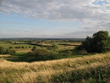
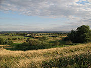
The village stood on a prominent ridge and was terraced into the hillside - archaeological
excavations have revealed the former locations of a central church, two sites with moats and a probable mill. The site of the manor
of Clopton, Clopton Bury, had a rectangular moat linked to the mill in the south-east of the village.
The village started to decline in the later Middle Ages and was deserted for good in the early 16th century after inclosure, begun around 1500, deprived the villagers of their livelihood. By 1524, the only households left belonged to the lady of the manor and five labourers. Today, earthworks outline the site of the village.
by two councillors for the Gamlingay ward and on Cambridgeshire County Council
by one councillor for the Gamlingay electoral division. It is in the parliamentary constituency of South Cambridgeshire, represented at the House of Commons by Andrew Lansley
.
, 10 miles (16.1 km) south-west of the county town of Cambridge and 44 miles (70.8 km) north of London
, a short distance west of what was the Roman Ermine Street, now the A1198 road. The village of Arrington
is east of Croydon, Wendy
is south-east and Hatley
north-west. The River Cam
(or Rhee) runs along the southern boundary of Croydon parish. The soil at Croydon is 'clayey' with a chalk and gault subsoil. The parish ranges from 22 metres, by the river, via the foot of a chalk down at 45 metres, to a northern plateau reaching 82 metres above sea level. It covers an area of 1,103 hectares.
, 1.4% followed another religion and 19.1% followed no religion or did not state one. Croydon parish had 208 inhabitants in 1801 and around 325 in the 1900s but in 1971 the population had fallen again to 205.
along Tadlow Road.
; it is constructed of brick and field stones in the Perpendicular style. In 1561 it was described as 'ampla et ornata' and said to be in decay; Sir John Cage made efforts to improve it in the 1620s and Sir George Downing rebuilt the chancel in brick and established a family vault. There are some pictures and a description of the church at the Cambridgeshire Churches website .
Another church was built at Clopton in the late 12th century on a terrace; it was reconsecrated in 1352 and measured around 40 feet (12.2 m) by 20 feet (6.1 m). It was in poor repair by 1561 and was turned over to agricultural use before 1660 and was demolished, with even the foundations removed.
South Cambridgeshire
South Cambridgeshire is a mostly rural local government district of Cambridgeshire, England. It was formed on 1 April 1974 by the merger of Chesterton Rural District and South Cambridgeshire Rural District. It surrounds the city of Cambridge, which is administered separately from the district by...
Cambridgeshire
Cambridgeshire
Cambridgeshire is a county in England, bordering Lincolnshire to the north, Norfolk to the northeast, Suffolk to the east, Essex and Hertfordshire to the south, and Bedfordshire and Northamptonshire to the west...
, England
England
England is a country that is part of the United Kingdom. It shares land borders with Scotland to the north and Wales to the west; the Irish Sea is to the north west, the Celtic Sea to the south west, with the North Sea to the east and the English Channel to the south separating it from continental...
. It is 10 miles (16.1 km) south-west of Cambridge
Cambridge
The city of Cambridge is a university town and the administrative centre of the county of Cambridgeshire, England. It lies in East Anglia about north of London. Cambridge is at the heart of the high-technology centre known as Silicon Fen – a play on Silicon Valley and the fens surrounding the...
and immediately west of the A1198 road
A1198 road
The A1198 is a road in Cambridgeshire, England, following the route of Ermine Street between the A505 at Royston, Hertfordshire and Godmanchester, near Huntingdon....
(the Roman
Roman Empire
The Roman Empire was the post-Republican period of the ancient Roman civilization, characterised by an autocratic form of government and large territorial holdings in Europe and around the Mediterranean....
Ermine Street
Ermine Street
Ermine Street is the name of a major Roman road in England that ran from London to Lincoln and York . The Old English name was 'Earninga Straete' , named after a tribe called the Earningas, who inhabited a district later known as Armingford Hundred, around Arrington, Cambridgeshire and Royston,...
). The population in 2001 was 221 people. The site of the deserted medieval village of Clopton is in Croydon parish, which was formerly known as Croydon-cum-Clopton.
History
The village's name was spelled Crauudene in the 1086 Domesday bookDomesday Book
Domesday Book , now held at The National Archives, Kew, Richmond upon Thames in South West London, is the record of the great survey of much of England and parts of Wales completed in 1086...
- it is derived from the Old English
Old English language
Old English or Anglo-Saxon is an early form of the English language that was spoken and written by the Anglo-Saxons and their descendants in parts of what are now England and southeastern Scotland between at least the mid-5th century and the mid-12th century...
crawe and denu, meaning 'valley of the crows'. The parish is now known as Croydon, but it used to be called 'Croydon-with-Clopton' or 'Croydon-cum-Clopton' -
In 1086, about 28 peasants lived at Croydon. The separate vill
Vill
Vill is a term used in English history to describe a land unit which might otherwise be described as a parish, manor or tithing.The term is used in the period immediately after the Norman conquest and into the late medieval. Land units in Domesday are frequently referred to as vills, although the...
s of Croydon and Clopton were joined in 1561 and Croydon's population may have increased to around 140 people early in the 17th century, but fell to 90 during the reign of Charles II. Open fields surrounding Croydon village were inclosed for pasture around 1640, but from the late 18th century arable farming recommenced.
Current-day Croydon grew up along a street which runs east-west along the ridge to the north of the parish. Some timber-framed houses dating from the late 17th or early 18th centuries still stand, though most of the cottages date from the early 19th century. The main route through the parish followed a terrace along the steep hillside towards Tadlow
Tadlow
Tadlow is south-west of Cambridge, north-east of Biggleswade, Bedfordshire, and north of London. The B1042 road bisects the parish, with Wrestlingworth to the west and Croydon to the east....
. The track, called 'Royston road', was improved and incorporated into the Cambridge
Cambridge
The city of Cambridge is a university town and the administrative centre of the county of Cambridgeshire, England. It lies in East Anglia about north of London. Cambridge is at the heart of the high-technology centre known as Silicon Fen – a play on Silicon Valley and the fens surrounding the...
-Biggleswade
Biggleswade
Biggleswade is a market town and civil parish located on the River Ivel in Bedfordshire, England. It is well served by transport routes, being close to the A1 road between London and the North, as well as having a railway station on the main rail link North from London .-Geography:Located about 40...
turnpike
Turnpike trust
Turnpike trusts in the United Kingdom were bodies set up by individual Acts of Parliament, with powers to collect road tolls for maintaining the principal highways in Britain from the 17th but especially during the 18th and 19th centuries...
, later became the A603 and it has now been downgraded to the B1042. Croydon Old Lane, in the north, went towards Hatley
Hatley, Cambridgeshire
Hatley is a civil parish in South Cambridgeshire, England. It lies between the villages of Gamlingay and Croydon, 12 miles south-west of the city of Cambridge and eight miles south-east of the town of St Neots...
, while the current road up Croydon Hill to Hatley was first built in 1830.
Clopton
Clopton, Cambridgeshire
Clopton is a deserted medieval village about south west of Croydon that once stood on a prominent ridge overlooking the countryside of Cambridgeshire, England...
was a medieval village which was deserted in the 16th century. It has been designated a Scheduled Ancient Monument
Scheduled Ancient Monument
In the United Kingdom, a scheduled monument is a 'nationally important' archaeological site or historic building, given protection against unauthorized change. The various pieces of legislation used for legally protecting heritage assets from damage and destruction are grouped under the term...
and is west of Croydon village; a footpath known as the 'Clopton Way' runs past it. There were signs of Roman
Roman Empire
The Roman Empire was the post-Republican period of the ancient Roman civilization, characterised by an autocratic form of government and large territorial holdings in Europe and around the Mediterranean....
occupation at Clopton and a 30 acres (121,405.8 m²) Anglo-Saxon village was in place by the 10th century. It was mentioned in the 1086 Domesday book
Domesday Book
Domesday Book , now held at The National Archives, Kew, Richmond upon Thames in South West London, is the record of the great survey of much of England and parts of Wales completed in 1086...
, when 18 peasants were in residence and a Friday market was granted in 1292 to Robert Hoo, lord of Clopton.
The village stood on a prominent ridge and was terraced into the hillside - archaeological
Archaeology
Archaeology, or archeology , is the study of human society, primarily through the recovery and analysis of the material culture and environmental data that they have left behind, which includes artifacts, architecture, biofacts and cultural landscapes...
excavations have revealed the former locations of a central church, two sites with moats and a probable mill. The site of the manor
Manorialism
Manorialism, an essential element of feudal society, was the organizing principle of rural economy that originated in the villa system of the Late Roman Empire, was widely practiced in medieval western and parts of central Europe, and was slowly replaced by the advent of a money-based market...
of Clopton, Clopton Bury, had a rectangular moat linked to the mill in the south-east of the village.
The village started to decline in the later Middle Ages and was deserted for good in the early 16th century after inclosure, begun around 1500, deprived the villagers of their livelihood. By 1524, the only households left belonged to the lady of the manor and five labourers. Today, earthworks outline the site of the village.
Governance
Croydon parish council consists of seven councillors and a parish clerk. The parish is represented on South Cambridgeshire District CouncilSouth Cambridgeshire District Council
South Cambridgeshire District Council is the local authority for the district of South Cambridgeshire in Cambridgeshire, England. Based in Cambourne, it forms the lower part of the two tier system of local government in the district, below Cambridgeshire County Council...
by two councillors for the Gamlingay ward and on Cambridgeshire County Council
Cambridgeshire County Council
Cambridgeshire County Council is the county council of Cambridgeshire, England. The council currently consists of 69 councillors, representing 60 electoral divisions. The Conservative Party has a majority on the council, having gained control in the 1997 local elections...
by one councillor for the Gamlingay electoral division. It is in the parliamentary constituency of South Cambridgeshire, represented at the House of Commons by Andrew Lansley
Andrew Lansley
Andrew David Lansley, CBE, MP is the UK Secretary of State for Health, who has been the Conservative Member of Parliament for South Cambridgeshire since the 1997 general election, and was Shadow Secretary of State for Health from June 2004 until becoming Secretary of State for Health in May 2010...
.
Geography
It is 6 miles (9.7 km) north-west of RoystonRoyston, Hertfordshire
Royston is a town and civil parish in the District of North Hertfordshire and county of Hertfordshire in England.It is situated on the Greenwich Meridian, which brushes the towns western boundary, and at the northernmost apex of the county on the same latitude of towns such as Milton Keynes and...
, 10 miles (16.1 km) south-west of the county town of Cambridge and 44 miles (70.8 km) north of London
London
London is the capital city of :England and the :United Kingdom, the largest metropolitan area in the United Kingdom, and the largest urban zone in the European Union by most measures. Located on the River Thames, London has been a major settlement for two millennia, its history going back to its...
, a short distance west of what was the Roman Ermine Street, now the A1198 road. The village of Arrington
Arrington
Arrington is a village and civil parish in the South Cambridgeshire district of Cambridgeshire, England, with a population of 389 at the time of 2001 census. The village is north of Royston, Hertfordshire, and south-west of the county town of Cambridge....
is east of Croydon, Wendy
Wendy, Cambridgeshire
Wendy is a hamlet in the civil parish of Shingay cum Wendy in South Cambridgeshire, England around 5 miles north west of Royston.-History:Wendy was a separate parish until 1957 when it was merged with neighbouring Shingay to form the present civil parish of Shingay cum Wendy. The historical parish...
is south-east and Hatley
Hatley, Cambridgeshire
Hatley is a civil parish in South Cambridgeshire, England. It lies between the villages of Gamlingay and Croydon, 12 miles south-west of the city of Cambridge and eight miles south-east of the town of St Neots...
north-west. The River Cam
River Cam
The River Cam is a tributary of the River Great Ouse in the east of England. The two rivers join to the south of Ely at Pope's Corner. The Great Ouse connects the Cam to England's canal system and to the North Sea at King's Lynn...
(or Rhee) runs along the southern boundary of Croydon parish. The soil at Croydon is 'clayey' with a chalk and gault subsoil. The parish ranges from 22 metres, by the river, via the foot of a chalk down at 45 metres, to a northern plateau reaching 82 metres above sea level. It covers an area of 1,103 hectares.
Demography
At the time of the 2001 census, Croydon parish had 221 residents living in 89 households. The ethnic group of 98.6% of people was white; 1.4 described themselves as Asian or Asian British. 79.5% were ChristianChristian
A Christian is a person who adheres to Christianity, an Abrahamic, monotheistic religion based on the life and teachings of Jesus of Nazareth as recorded in the Canonical gospels and the letters of the New Testament...
, 1.4% followed another religion and 19.1% followed no religion or did not state one. Croydon parish had 208 inhabitants in 1801 and around 325 in the 1900s but in 1971 the population had fallen again to 205.
Landmarks
A war memorial stands on Church Lane and commemorates Croydon men who were killed in the First and Second World Wars. Three buildings in the parish are listed: the parish church, a row of cottages along Larkins Road and a milestoneMilestone
A milestone is one of a series of numbered markers placed along a road or boundary at intervals of one mile or occasionally, parts of a mile. They are typically located at the side of the road or in a median. They are alternatively known as mile markers, mileposts or mile posts...
along Tadlow Road.
Religious sites
Croydon's church was established by the late 12th century and was dedicated to All Saints by at least 1520. It stands on a slope above the village street and has had problems with subsidenceSubsidence
Subsidence is the motion of a surface as it shifts downward relative to a datum such as sea-level. The opposite of subsidence is uplift, which results in an increase in elevation...
; it is constructed of brick and field stones in the Perpendicular style. In 1561 it was described as 'ampla et ornata' and said to be in decay; Sir John Cage made efforts to improve it in the 1620s and Sir George Downing rebuilt the chancel in brick and established a family vault. There are some pictures and a description of the church at the Cambridgeshire Churches website .
Another church was built at Clopton in the late 12th century on a terrace; it was reconsecrated in 1352 and measured around 40 feet (12.2 m) by 20 feet (6.1 m). It was in poor repair by 1561 and was turned over to agricultural use before 1660 and was demolished, with even the foundations removed.