
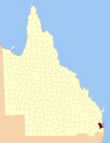
County of Stanley, Queensland
Encyclopedia
County
A county is a jurisdiction of local government in certain modern nations. Historically in mainland Europe, the original French term, comté, and its equivalents in other languages denoted a jurisdiction under the sovereignty of a count A county is a jurisdiction of local government in certain...
in Queensland
Queensland
Queensland is a state of Australia, occupying the north-eastern section of the mainland continent. It is bordered by the Northern Territory, South Australia and New South Wales to the west, south-west and south respectively. To the east, Queensland is bordered by the Coral Sea and Pacific Ocean...
, Australia
Australia
Australia , officially the Commonwealth of Australia, is a country in the Southern Hemisphere comprising the mainland of the Australian continent, the island of Tasmania, and numerous smaller islands in the Indian and Pacific Oceans. It is the world's sixth-largest country by total area...
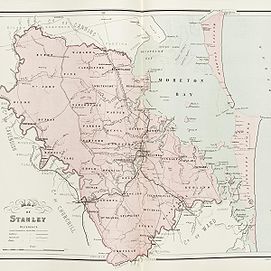
. Like all counties in Queensland, it is a non-functional administrative unit, that is used mainly for the purpose of registering land titles. It was named after Edward Stanley
Edward Smith-Stanley, 14th Earl of Derby
Edward George Geoffrey Smith-Stanley, 14th Earl of Derby, KG, PC was an English statesman, three times Prime Minister of the United Kingdom, and to date the longest serving leader of the Conservative Party. He was known before 1834 as Edward Stanley, and from 1834 to 1851 as Lord Stanley...
, who was three times British Prime Minister in the 1850s and 1860s. It is bounded by the Logan River
Logan River
The Logan River is a river in South East Queensland. The catchment is dominated by urban and agricultural land use. Near the river mouth are mangrove forests and a number of aquaculture farms.-History:...
in the south, the Brisbane River
Brisbane River
The Brisbane River is the longest river in south east Queensland, Australia, and flows through the city of Brisbane, before emptying into Moreton Bay. John Oxley was the first European to explore the river who named it after the Governor of New South Wales, Thomas Brisbane in 1823...
at what is now Lake Wivenhoe in the west, the Stanley River
Stanley River (Queensland)
The Stanley River in Queensland is the main tributary of the Brisbane River. The Stanley River valley extends roughly 35 km westwards from the area south of Maleny to Kilcoy before veering southwards....
at what is now Lake Somerset
Lake Somerset
Lake Somerset is an artificial lake created by the Somerset Dam on the Stanley River in South East Queensland. The dam was completed in 1953 providing flood mitigation and water storage for the cities of Brisbane and Ipswich and is the site of a small 4 MW hydroelectric power station.At full...
in the north-west, and Caboolture River
Caboolture River
The Caboolture River is a small river in South East Queensland. It rises in the D'Aguilar Range near Ocean View and flows through Caboolture and Morayfield before entering Deception Bay at Beachmere....
in the north. It includes Moreton Island
Moreton Island
Moreton Island is a large sand island on the eastern side of Moreton Bay, on the coast of south-east Queensland, Australia. Moreton Island lies 58 kilometres northeast of the Queensland capital, Brisbane. The island is 95% National Park and a popular destination for four wheel driving, camping,...
and Stradbroke Island
Stradbroke Island
Stradbroke Island, also known as Minjerribah, was a large sand island that formed much of the eastern side of Moreton Bay near Brisbane, Queensland until the late 19th century...
.
The county takes in the cities of Brisbane
Brisbane
Brisbane is the capital and most populous city in the Australian state of Queensland and the third most populous city in Australia. Brisbane's metropolitan area has a population of over 2 million, and the South East Queensland urban conurbation, centred around Brisbane, encompasses a population of...
, Ipswich
Ipswich, Queensland
Ipswich is a city in South-East Queensland, Australia. Situated along the Bremer River Valley approximately 40 kilometres away from the state's capital Brisbane. The suburb by the same name forms the city's Central Business District and administrative centre...
and Redcliffe, among others.
It was formerly a county in New South Wales
New South Wales
New South Wales is a state of :Australia, located in the east of the country. It is bordered by Queensland, Victoria and South Australia to the north, south and west respectively. To the east, the state is bordered by the Tasman Sea, which forms part of the Pacific Ocean. New South Wales...
between the establishment of Brisbane
Brisbane
Brisbane is the capital and most populous city in the Australian state of Queensland and the third most populous city in Australia. Brisbane's metropolitan area has a population of over 2 million, and the South East Queensland urban conurbation, centred around Brisbane, encompasses a population of...
in 1826, and the formation of Queensland
Queensland
Queensland is a state of Australia, occupying the north-eastern section of the mainland continent. It is bordered by the Northern Territory, South Australia and New South Wales to the west, south-west and south respectively. To the east, Queensland is bordered by the Coral Sea and Pacific Ocean...
as a separate colony in 1860. In 1852 it had an area of 2,000,000 acres (8,000 km²) and population of 2,000, and was the most northerly county of New South Wales. Wheat
Wheat
Wheat is a cereal grain, originally from the Levant region of the Near East, but now cultivated worldwide. In 2007 world production of wheat was 607 million tons, making it the third most-produced cereal after maize and rice...
, coffee
Coffee
Coffee is a brewed beverage with a dark,init brooo acidic flavor prepared from the roasted seeds of the coffee plant, colloquially called coffee beans. The beans are found in coffee cherries, which grow on trees cultivated in over 70 countries, primarily in equatorial Latin America, Southeast Asia,...
, cotton
Cotton
Cotton is a soft, fluffy staple fiber that grows in a boll, or protective capsule, around the seeds of cotton plants of the genus Gossypium. The fiber is almost pure cellulose. The botanical purpose of cotton fiber is to aid in seed dispersal....
and tobacco
Tobacco
Tobacco is an agricultural product processed from the leaves of plants in the genus Nicotiana. It can be consumed, used as a pesticide and, in the form of nicotine tartrate, used in some medicines...
were described as being important crops. It was part of the New South Wales electoral district of Stanley between 1856 and 1859.
Parishes
Stanley is divided into parishes, listed as follows:| Parish | LGA | Coordinates |
|---|---|---|
| Bulimba Bulimba, Queensland Bulimba is an inner suburb of Brisbane, Australia. It is 4 kilometres south-east of the CBD, and is located on the southern bank of the Brisbane River... |
Brisbane City of Brisbane The City of Brisbane is the Local Government Area that has jurisdiction over the inner portion of the metropolitan area of Brisbane, Queensland, Australia... |
27°29′S 153°04′E |
| Bundamba Bundamba, Queensland Bundamba is a large suburb of Ipswich, Queensland, Australia.Bundamba stretches from the Bremer River to the north, across Brisbane Rd, the main arterial link to the Ipswich Motorway, to the Cunningham Highway in the south... |
Ipswich City of Ipswich The City of Ipswich is a Local Government Area in South East Queensland, covering an area of along the coast about southwest of Brisbane, the capital of Queensland. The City of Ipswich has a population of 162,380 .-History:... |
27°42′S 152°50′E |
| Bunya Bunya, Queensland Bunya is a suburb north-west of Brisbane, the capital city of Queensland, Australia. Its local government area is the Moreton Bay Region.Bunya is home to the Bunyaville Forest Reserve, operated by the Queensland Parks and Wildlife Service. Spotted gum, grey ironbark, narrow-leaved ironbark, white... |
Moreton Bay | 27°22′S 152°56′E |
| Burnett Burnett, Queensland The Shire of Burnett was a Local Government Area located in the Wide Bay-Burnett region of Queensland, Australia. It completely surrounded, but did not include, the regional city of Bundaberg, and covered an area of... |
Somerset | 27°23′S 152°40′E |
| Burpengary Burpengary, Queensland Burpengary is a suburb 35 kilometres from the Brisbane CBD, in Queensland, Australia. Its Local Government Area is the Moreton Bay Region.The name is derived from the Aboriginal word burpengar, meaning the "land of the golden wattle".... |
Moreton Bay | 27°08′S 152°59′E |
| Byron | Somerset | 27°04′S 152°41′E |
| Caboolture | Moreton Bay | 27°07′S 152°52′E |
| Capalaba Capalaba, Queensland Capalaba is a suburb of southeastern of Brisbane, Queensland, Australia, located in the Redland City local government area.The suburb has two large shopping and commercial centres with a mall and bus station, and light industrial zones surrounded by residential streets and bushland... |
Redland | 27°32′S 153°11′E |
| Chuwar Chuwar, Queensland Chuwar is a suburb of both Ipswich, Australia and Brisbane in South East Queensland, Australia. It is north of the Ipswich central business district, west of Brisbane by road.... |
Ipswich City of Ipswich The City of Ipswich is a Local Government Area in South East Queensland, covering an area of along the coast about southwest of Brisbane, the capital of Queensland. The City of Ipswich has a population of 162,380 .-History:... |
27°34′S 152°48′E |
| Cleveland Cleveland, Queensland Cleveland is a suburb located approximately east-south-east of Brisbane, the capital of the Australian state of Queensland, and is the council seat for the Redland City local government area... |
Redland | 27°32′S 153°18′E |
| Dixon | Somerset | 27°12′S 152°33′E |
| Dundas | Somerset | 27°19′S 152°41′E |
| Enoggera Enoggera, Queensland Enoggera is a suburb of Brisbane, in Queensland, Australia. The suburb is located 6 km north-west of the Brisbane CBD.-History:In 1845 John Brennan purchased six hectares of land in Enoggera. Six years later, Thomas Hayes moved to the area and bought thirty-three acres of land... |
Brisbane City of Brisbane The City of Brisbane is the Local Government Area that has jurisdiction over the inner portion of the metropolitan area of Brisbane, Queensland, Australia... |
27°25′S 152°56′E |
| Goodna Goodna, Queensland Goodna is a suburb on the eastern edge of the City of Ipswich in Queensland, Australia.It is bounded to the north by the Brisbane River. Founded in 1856 when the area was still part of New South Wales, it celebrated its 150 year anniversary in 2006. Its beginnings can be traced back further to... |
Ipswich City of Ipswich The City of Ipswich is a Local Government Area in South East Queensland, covering an area of along the coast about southwest of Brisbane, the capital of Queensland. The City of Ipswich has a population of 162,380 .-History:... |
27°37′S 152°51′E |
| Indooroopilly Indooroopilly, Queensland Indooroopilly is a suburb of Brisbane, Australia which is located 7 km west of the Brisbane central business district.- Name derivation and history :... |
Brisbane City of Brisbane The City of Brisbane is the Local Government Area that has jurisdiction over the inner portion of the metropolitan area of Brisbane, Queensland, Australia... |
27°30′S 152°59′E |
| Ipswich Ipswich, Queensland Ipswich is a city in South-East Queensland, Australia. Situated along the Bremer River Valley approximately 40 kilometres away from the state's capital Brisbane. The suburb by the same name forms the city's Central Business District and administrative centre... |
Ipswich City of Ipswich The City of Ipswich is a Local Government Area in South East Queensland, covering an area of along the coast about southwest of Brisbane, the capital of Queensland. The City of Ipswich has a population of 162,380 .-History:... |
27°39′S 152°47′E |
| Kedron Kedron, Queensland Kedron is a northern suburb of Brisbane, Australia, centred on Gympie Road and Kedron Brook. It is close to Westfield Chermside shopping centre in the neighbouring suburb of Chermside... |
Brisbane City of Brisbane The City of Brisbane is the Local Government Area that has jurisdiction over the inner portion of the metropolitan area of Brisbane, Queensland, Australia... |
27°22′S 153°00′E |
| Kholo Kholo, Queensland Kholo is an outer suburb of Brisbane, Australia located 22 km south-west of the Brisbane CBD. Kholo became part of the Brisbane City in 1999.-External links:* *... |
Brisbane City of Brisbane The City of Brisbane is the Local Government Area that has jurisdiction over the inner portion of the metropolitan area of Brisbane, Queensland, Australia... |
27°29′S 152°48′E |
| Mackenzie Mackenzie, Queensland Mackenzie is a small suburb located in the south-east of Brisbane, Queensland, Australia. This is an "out-back" suburb containing no large or small shopping centres. The area is partially covered by undeveloped bushland. Mount Petrie is located in Mackenzie.... |
Logan | 27°40′S 153°07′E |
| Maclean | Scenic Rim | 27°47′S 152°57′E |
| Mitchell | Logan | 27°40′S 153°00′E |
| Moggill Moggill, Queensland Moggill is one of Brisbane's western suburbs, about from the CBD. It comprises a mixture of small-lot and acreage residential homes along with a small number of remaining farms... |
Brisbane City of Brisbane The City of Brisbane is the Local Government Area that has jurisdiction over the inner portion of the metropolitan area of Brisbane, Queensland, Australia... |
27°31′S 152°52′E |
| North Brisbane Parish of North Brisbane, Queensland The Parish of North Brisbane is a parish within the County of Stanley, Queensland. It includes in its area the Brisbane CBD and the suburb of Fortitude Valley.... |
Brisbane City of Brisbane The City of Brisbane is the Local Government Area that has jurisdiction over the inner portion of the metropolitan area of Brisbane, Queensland, Australia... |
27°27′S 153°02′E |
| Nundah Nundah, Queensland Nundah is an inner suburb in the city of Brisbane, Australia, located approximately 8 kilometers north-east of the Brisbane central business district, in the local government area of the City of Brisbane.... |
Brisbane City of Brisbane The City of Brisbane is the Local Government Area that has jurisdiction over the inner portion of the metropolitan area of Brisbane, Queensland, Australia... |
27°19′S 153°03′E |
| Oxley Oxley, Queensland Oxley is a south-western suburb of Brisbane located approximately 11 km from the Brisbane CBD. It was named after the early Australian explorer John Oxley. The suburb supports a mix of residential, retail and industrial land use.... |
Brisbane City of Brisbane The City of Brisbane is the Local Government Area that has jurisdiction over the inner portion of the metropolitan area of Brisbane, Queensland, Australia... |
27°34′S 152°56′E |
| Parker | Moreton Bay | 27°21′S 152°48′E |
| Perry | Scenic Rim | 27°44′S 153°00′E |
| Pine Strathpine, Queensland Strathpine is a suburb north of Brisbane, Queensland, Australia. Its Local Government Area is the Moreton Bay Region. It is home to the Pine Rivers District offices of the Moreton Bay Region as well as many businesses. The area contains a medium-sized Westfield shopping centre... |
Moreton Bay | 27°07′S 152°47′E |
| Redcliffe Redcliffe, Queensland Redcliffe is a residential suburb of the Moreton Bay Region in the north-east of the Redcliffe peninsula, approximately north-northeast of Brisbane, the state capital of Queensland, Australia... |
Moreton Bay | 27°14′S 153°03′E |
| Redland Redland Bay, Queensland Redland Bay is a suburb south-east of Brisbane, the capital of Queensland, Australia, and is part of the Redland City local government area. It is named for the bay it sits on, which forms part of larger Moreton Bay... |
Redland | 27°37′S 153°15′E |
| Sahl | Somerset | 27°25′S 152°44′E |
| Samford Samford, Queensland Samford is a valley community located in South East Queensland, Australia. It is roughly 21 km north west of Brisbane. The hilly area was first settled in the mid 1850s. The community is well catered for, with a number of sporting facilities, parks and museums.-Location:Samford is one of the... |
Moreton Bay | 27°23′S 152°51′E |
| Samsonvale Samsonvale, Queensland Samsonvale is a locality within the Moreton Bay Region of Queensland, Australia.The district is dominated by Lake Samsonvale, the waters of North Pine Dam, one of the three main water-suppliers to the metropolitan region... |
Moreton Bay | 27°14′S 152°47′E |
| South Brisbane South Brisbane, Queensland South Brisbane is an inner city suburb of Brisbane, Australia located on the southern bank of the Brisbane River, directly connected to the central business district by the Kurilpa, Victoria and Goodwill bridges.... |
Brisbane City of Brisbane The City of Brisbane is the Local Government Area that has jurisdiction over the inner portion of the metropolitan area of Brisbane, Queensland, Australia... |
27°29′S 153°00′E |
| St John | Somerset | 27°12′S 152°40′E |
| Stapylton | Ipswich City of Ipswich The City of Ipswich is a Local Government Area in South East Queensland, covering an area of along the coast about southwest of Brisbane, the capital of Queensland. The City of Ipswich has a population of 162,380 .-History:... |
27°42′S 152°55′E |
| Tingalpa Tingalpa, Queensland Tingalpa is located near Manly West and Belmont, Queensland in the Eastern suburbs of Brisbane, Australia. It is located east of the Brisbane CBD.... |
Brisbane City of Brisbane The City of Brisbane is the Local Government Area that has jurisdiction over the inner portion of the metropolitan area of Brisbane, Queensland, Australia... |
27°30′S 153°08′E |
| Toombul | Brisbane City of Brisbane The City of Brisbane is the Local Government Area that has jurisdiction over the inner portion of the metropolitan area of Brisbane, Queensland, Australia... |
27°23′S 153°06′E |
| Undullah | Scenic Rim | 27°49′S 152°52′E |
| Wararba | Moreton Bay | 27°02′S 152°51′E |
| Warner Warner, Queensland Warner is a suburb north of Brisbane, Queensland, Australia. Its Local Government Area is the Moreton Bay Region located 22 kilometres north of the Brisbane central business district. Warner is situated east of Lake Samsonvale and west of the urban localities of Strathpine, Brendale, Bray Park and... |
Moreton Bay | 27°19′S 152°56′E |
| Whiteside | Moreton Bay | 27°13′S 152°53′E |
| Woogaro | Logan | 27°38′S 152°57′E |