
Enoggera, Queensland
Encyclopedia
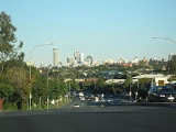
Enoggera is a suburb of Brisbane
, in Queensland
, Australia
. The suburb is located 6 km north-west of the Brisbane CBD.
s of land in Enoggera. Six years later, Thomas Hayes moved to the area and bought thirty-three acre
s of land. Enoggera initially developed as a farming community with orchard
s and vineyard
s.
In the 1860s, the track to the Gympie
goldfields passed through Enoggera, and this assisted with development. As the population increased, the first school opened in 1871, and the railway line to Enoggera Station
opened in 1899.
In 1887, the local government Division of Enoggera was proclaimed, bound to north and south by Kedron Brook and Enoggera Creek, and stretching from Alderley
to The Gap
and beyond the Enoggera Dam
. Enoggera became a shire in 1903 before being amalgamated into the City of Brisbane in 1925. In 1949 the tram
line from Newmarket
was extended along Samford Road to Enoggera. The tram line closed on 2 December 1968.
, Our Lady of The Assumption, Enoggera State School and the grade eight to nine campus of Mt Maria College
.
and Enoggera Railway Station
provide access to regular Citytrain
services on the Ferny Grove railway line arranging travel to the Brisbane CBD, Beenleigh
and Ferny Grove
.
Via Bus, Enoggera is serviced by Brisbane Transport
buses, predominantly from the bus-rail interchange at Enoggera Railway Station
and at Wardell Street, which travel to the Brisbane CBD, Chermside
, Ashgrove
and Indooroopilly
.
Via Road, Enoggera's main arterials are Samford Road which is the main corridor for motorists travelling to The City, Mitchelton
and Samford
, as well as Wardell Street which is the main corridor for motorists travelling to the Inner Western suburbs such as Paddington
and Toowong
.
was acquired in 1910, and opened in the same year. The Army Barracks is still located in Enoggera today.
Brisbane
Brisbane is the capital and most populous city in the Australian state of Queensland and the third most populous city in Australia. Brisbane's metropolitan area has a population of over 2 million, and the South East Queensland urban conurbation, centred around Brisbane, encompasses a population of...
, in Queensland
Queensland
Queensland is a state of Australia, occupying the north-eastern section of the mainland continent. It is bordered by the Northern Territory, South Australia and New South Wales to the west, south-west and south respectively. To the east, Queensland is bordered by the Coral Sea and Pacific Ocean...
, Australia
Australia
Australia , officially the Commonwealth of Australia, is a country in the Southern Hemisphere comprising the mainland of the Australian continent, the island of Tasmania, and numerous smaller islands in the Indian and Pacific Oceans. It is the world's sixth-largest country by total area...
. The suburb is located 6 km north-west of the Brisbane CBD.
History
In 1845 John Brennan purchased six hectareHectare
The hectare is a metric unit of area defined as 10,000 square metres , and primarily used in the measurement of land. In 1795, when the metric system was introduced, the are was defined as being 100 square metres and the hectare was thus 100 ares or 1/100 km2...
s of land in Enoggera. Six years later, Thomas Hayes moved to the area and bought thirty-three acre
Acre
The acre is a unit of area in a number of different systems, including the imperial and U.S. customary systems. The most commonly used acres today are the international acre and, in the United States, the survey acre. The most common use of the acre is to measure tracts of land.The acre is related...
s of land. Enoggera initially developed as a farming community with orchard
Orchard
An orchard is an intentional planting of trees or shrubs that is maintained for food production. Orchards comprise fruit or nut-producing trees which are grown for commercial production. Orchards are also sometimes a feature of large gardens, where they serve an aesthetic as well as a productive...
s and vineyard
Vineyard
A vineyard is a plantation of grape-bearing vines, grown mainly for winemaking, but also raisins, table grapes and non-alcoholic grape juice...
s.
In the 1860s, the track to the Gympie
Gympie
Gympie may refer to:* Gympie, a city in Queensland, Australia** Gympie Airport** Electoral district of Gympie** Gympie Region, its local government authority* Gympie Gympie , a stinging plant...
goldfields passed through Enoggera, and this assisted with development. As the population increased, the first school opened in 1871, and the railway line to Enoggera Station
Enoggera railway station, Brisbane
Enoggera Station is a railway station on the Ferny Grove Line of Brisbane, Australia. It is part of the Queensland Rail City network.It is in Zone 2 of the TransLink integrated public transport system.-Services by platform:-External links:***...
opened in 1899.
In 1887, the local government Division of Enoggera was proclaimed, bound to north and south by Kedron Brook and Enoggera Creek, and stretching from Alderley
Alderley, Queensland
Alderley is a suburb of Brisbane, Queensland, Australia. It is north-west of the CBD. It is surrounded by Newmarket in the south, Ashgrove and Enoggera in the west, Grange and Stafford in the east and Kedron and Everton Park in the north. At the 2006 census, it had a populatio of 5,068.In...
to The Gap
The Gap, Queensland
The Gap is a leafy and hilly suburb of Brisbane, in Queensland, Australia, located approximately 11 km west of the Brisbane CBD.-Geography:...
and beyond the Enoggera Dam
Enoggera Dam
The Enoggera Dam, which is located within the inner, western suburb of Enoggera Reservoir, in Brisbane, Queensland, and was constructed in 1866. It was built on Enoggera Creek and was the first major dam built in Queensland...
. Enoggera became a shire in 1903 before being amalgamated into the City of Brisbane in 1925. In 1949 the tram
Tram
A tram is a passenger rail vehicle which runs on tracks along public urban streets and also sometimes on separate rights of way. It may also run between cities and/or towns , and/or partially grade separated even in the cities...
line from Newmarket
Newmarket, Queensland
Newmarket is an inner north-western suburb of Brisbane, Queensland, Australia. It is located approximately 5 km from the Brisbane central business district and is surrounded by the suburbs of Alderley to the north, Ashgrove to the west, Kelvin Grove to the south, and Wilston to the east...
was extended along Samford Road to Enoggera. The tram line closed on 2 December 1968.
Education
Enoggera is home to several high quality educational institutions, including Hillbrook Anglican SchoolHillbrook Anglican School
Hillbrook Anglican School is a co-educational, Anglican independent school, in Brisbane, Australia. The school is one of the few Anglican schools in Brisbane which specialises in high school education only.-History:...
, Our Lady of The Assumption, Enoggera State School and the grade eight to nine campus of Mt Maria College
Mt Maria College
Mt Maria College is a Catholic, Secondary Coeducational College located in northside Brisbane on two campuses. It offers both an OP course and a VET course for students. It is part of Brisbane Catholic Education.-Location:...
.
Transport
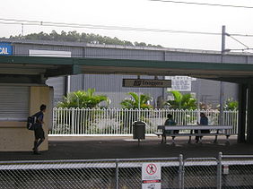
Via Train, Gaythorne Railway StationGaythorne railway station, Brisbane
Gaythorne Station is a railway station on the Ferny Grove Line of Brisbane, Australia. It is part of the Queensland Rail City network.It is in a transition precinct between Zone 2 and Zone 3 of the TransLink integrated public transport system....
and Enoggera Railway Station
Enoggera railway station, Brisbane
Enoggera Station is a railway station on the Ferny Grove Line of Brisbane, Australia. It is part of the Queensland Rail City network.It is in Zone 2 of the TransLink integrated public transport system.-Services by platform:-External links:***...
provide access to regular Citytrain
CityTrain
Citytrain is the brand name of urban, suburban and inter-urban electric passenger railway services in South East Queensland, Australia. Its network, centering in Brisbane, the state capital of Queensland, is approximately in route length...
services on the Ferny Grove railway line arranging travel to the Brisbane CBD, Beenleigh
Beenleigh, Queensland
Beenleigh is a suburb in the Logan City area of Queensland, Australia. Beenleigh and adjoining suburbs are located near the confluence of the Logan and Albert rivers...
and Ferny Grove
Ferny Grove, Queensland
Ferny Grove is a residential suburb in north-west Brisbane, Queensland, Australia. It lies entirely within the Brisbane-metropolitan area administered by the Brisbane City Council.-General information:...
.
Via Bus, Enoggera is serviced by Brisbane Transport
Brisbane Transport
Brisbane Transport is a business unit of Brisbane City Council, operating suburban and urban bus services under the TransLink integrated public transport scheme in Brisbane, the state capital of Queensland, Australia. The origins of Brisbane Transport can be seen as far back as 1885 when horse...
buses, predominantly from the bus-rail interchange at Enoggera Railway Station
Enoggera railway station, Brisbane
Enoggera Station is a railway station on the Ferny Grove Line of Brisbane, Australia. It is part of the Queensland Rail City network.It is in Zone 2 of the TransLink integrated public transport system.-Services by platform:-External links:***...
and at Wardell Street, which travel to the Brisbane CBD, Chermside
Chermside Bus Station, Brisbane
The Chermside Bus Station, at Chermside, is serviced by TransLink bus routes. It is part of the Westfield Chermside Shopping Centre. It is in a transition precinct between Zone 3 and Zone 4 of the TransLink integrated public transport system....
, Ashgrove
Ashgrove, Queensland
Ashgrove is an inner suburb of Brisbane in Queensland, Australia, located approximately 4 km north-west of the Brisbane CBD. Ashgrove is a leafy residential suburb, characterised by its hilly terrain and characteristic Ashgrovian houses built in the early 20th century...
and Indooroopilly
Indooroopilly, Queensland
Indooroopilly is a suburb of Brisbane, Australia which is located 7 km west of the Brisbane central business district.- Name derivation and history :...
.
Via Road, Enoggera's main arterials are Samford Road which is the main corridor for motorists travelling to The City, Mitchelton
Mitchelton, Queensland
Michelton is a suburb of Brisbane, in Queensland, Australia. The suburb is located 8 kilometres from the Brisbane central business district some areas of Mitchelton can be 6 km to the Brisbane central business district....
and Samford
Samford, Queensland
Samford is a valley community located in South East Queensland, Australia. It is roughly 21 km north west of Brisbane. The hilly area was first settled in the mid 1850s. The community is well catered for, with a number of sporting facilities, parks and museums.-Location:Samford is one of the...
, as well as Wardell Street which is the main corridor for motorists travelling to the Inner Western suburbs such as Paddington
Paddington, Queensland
Paddington is an inner suburb of Brisbane, Australia located 2 km west of the Brisbane CBD. As is common with other suburbs in the area, Paddington is located on a number of steep ridges and hills. It was originally settled in the 1860s. Many original and distinctive Queenslander homes can...
and Toowong
Toowong, Queensland
Toowong is an inner suburb of Brisbane, Australia which is located 5 km west of the Brisbane CBD. At the centre of Toowong is a commercial precinct including Toowong Village and several office buildings...
.
Military
The land for the Enoggera Army BarracksEnoggera Barracks
Enoggera Barracks is an Australian Army base in the northwestern Brisbane suburb of Enoggera in Queensland.-History:...
was acquired in 1910, and opened in the same year. The Army Barracks is still located in Enoggera today.