

Logan River
Encyclopedia
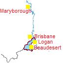
The Logan River is a river in South East Queensland
. The catchment is dominated by urban and agricultural land use. Near the river mouth are mangrove
forests and a number of aquaculture
farms.
. Logan initially named the river the Darling River, but to avoid confusion, Governor Ralph Darling
ordered the name be changed to honour its discoverer.
A toll bridge on the river north of Beenleigh
was collecting money by the late 1930's as weekend traffic between Brisbane and the Gold Coast increased.
The flooding in the lower reaches of the river were the worst for the 20th century during the 1974 Brisbane flood
.
 The river begins in the Mount Barney National Park
, near the New South Wales
border between Mount Lindesay and Mount Ernest, before heading north, east, and eventually flowing into Moreton Bay
. The Mount Lindesay Highway
crosses the river via Macleans Bridge.
Its principal tributaries are the Albert River which joins it just east of Beenleigh, Teviot Brook which begins at Mount Superbus
and joins the Logan River at Cedar Pocket and Burnett Creek which is subverted by the Maroon Dam
west of Rathdowney
.
subverts Burnnett Creek, and supplies water to the Beaudesert Shire
. Maroon is managed by SunWater
and covers approximately 106 km².
Several projects are underway, to supply water to the Queensland government's Southern Regional Pipeline. The Bromelton off-stream storage facility is currently under construction on the Logan River, outside Beaudesert, as is the Cedar Grove Weir
, near Jimboomba.
On July 4, 2006, the Queensland Government decided against the construction of a Logan River dam at Tilley's Bridge in Rathdowney, due to mounting public pressure and high road diversion costs. Instead, the Wyaralong Dam
was proposed on Teviot Brook near Boonah
, which will inundate 15 properties instead of the 100 for the Tilley's Bridge site.
The Tilley's Bridge dam, if it had been approved, would have inundated the area of land between Tilley's Bridge, just to the south of Rathdowney, and Bigriggan Camping Reserve, some eight kilometres west, covering a significant section of the Boonah-Rathdowney Road.
The annual Healthy Waterways Report Card for the waterways and catchments of South East Queensland rated the condition of the Logan River as very poor.
Much of the environmental degradation has been caused by land clearing, the Bromelton industrial estate, nutrient run-off and the pumping of wastewater directly from several wastewater treatment plants in and around the Logan River. In 2009, the Queensland Government's "Healthy Waterways EcosystemHealth Monitoring Program" rated the River's freshwater area at a "D"; its Estuarine area was given an "F".
Community projects exist in the Logan catchment area to clean up enhance the quality of the ecosystem. Competitions such as Carp-busters are aimed at reducing the number of carp
, and therefore allow native species of fish a better chance of survival.
South East Queensland
South East Queensland is a region of the state of Queensland in Australia, which contains approximately two-thirds of the state population...
. The catchment is dominated by urban and agricultural land use. Near the river mouth are mangrove
Mangrove
Mangroves are various kinds of trees up to medium height and shrubs that grow in saline coastal sediment habitats in the tropics and subtropics – mainly between latitudes N and S...
forests and a number of aquaculture
Aquaculture
Aquaculture, also known as aquafarming, is the farming of aquatic organisms such as fish, crustaceans, molluscs and aquatic plants. Aquaculture involves cultivating freshwater and saltwater populations under controlled conditions, and can be contrasted with commercial fishing, which is the...
farms.
History
The Logan was discovered in August 1826 by Captain Patrick LoganPatrick Logan
Captain Patrick Logan was the commandant of the Moreton Bay penal colony from 1826 until his death in 1830. He is thought to have been killed by Aboriginal Australians who objected to him entering their lands...
. Logan initially named the river the Darling River, but to avoid confusion, Governor Ralph Darling
Ralph Darling
General Sir Ralph Darling, GCH was a British colonial Governor and Governor of New South Wales from 1825 to 1831.-Early career:...
ordered the name be changed to honour its discoverer.
A toll bridge on the river north of Beenleigh
Beenleigh, Queensland
Beenleigh is a suburb in the Logan City area of Queensland, Australia. Beenleigh and adjoining suburbs are located near the confluence of the Logan and Albert rivers...
was collecting money by the late 1930's as weekend traffic between Brisbane and the Gold Coast increased.
The flooding in the lower reaches of the river were the worst for the 20th century during the 1974 Brisbane flood
1974 Brisbane flood
The 1974 Brisbane flood occurred in January 1974 in Brisbane, Queensland, Australia, when waterways in the city experienced significant flooding...
.
Course
Mount Barney National Park
Mount Barney National Park is a national park in Queensland , 90 km southwest of Brisbane. It amalgamated the adjacent Mount Lindesay National Park in 1980. It is part of the Scenic Rim Important Bird Area, identified as such by BirdLife International because of its importance in the conservation...
, near the New South Wales
New South Wales
New South Wales is a state of :Australia, located in the east of the country. It is bordered by Queensland, Victoria and South Australia to the north, south and west respectively. To the east, the state is bordered by the Tasman Sea, which forms part of the Pacific Ocean. New South Wales...
border between Mount Lindesay and Mount Ernest, before heading north, east, and eventually flowing into Moreton Bay
Moreton Bay
Moreton Bay is a bay on the eastern coast of Australia 45 km from Brisbane, Queensland. It is one of Queensland's most important coastal resources...
. The Mount Lindesay Highway
Mount Lindesay Highway
The Mount Lindesay Highway is a highway in Queensland which has been given the national route number 13. It runs from Brisbane, where it leaves Ipswich Road in the suburb of Moorooka , to the New South Wales border where it becomes the Summerland Way heading south to Kyogle.The highway used to...
crosses the river via Macleans Bridge.
Its principal tributaries are the Albert River which joins it just east of Beenleigh, Teviot Brook which begins at Mount Superbus
Mount Superbus
Mount Superbus lies 150 km south-west of Brisbane and is South East Queensland's highest peak at 1375 metres . At this elevation it is the third highest peak in Queensland. Only Mount Bellenden Ker at 1593 m and Mount Bartle Frere at 1622 m in Far North Queensland are higher.It has an...
and joins the Logan River at Cedar Pocket and Burnett Creek which is subverted by the Maroon Dam
Maroon Dam
Maroon Dam is a water storage and recreational dam in South East Queensland. The dam lies 25 km south of Boonah, within the Scenic Rim at the foot of the McPherson Range. Maroon Dam subverts the waters of Burnett Creek, a tributary of Logan River and supplies the Scenic Rim Regional Council with...
west of Rathdowney
Rathdowney, Queensland
Rathdowney is a small town in south-eastern Queensland, Australia. It is on the Mount Lindesay Highway 32 km south of Beaudesert at the base of the McPherson Range. It is located in the Scenic Rim Local Government Area. At the 2006 census, Rathdowney had a population of 198.The town was named...
.
Water harvesting
Maroon DamMaroon Dam
Maroon Dam is a water storage and recreational dam in South East Queensland. The dam lies 25 km south of Boonah, within the Scenic Rim at the foot of the McPherson Range. Maroon Dam subverts the waters of Burnett Creek, a tributary of Logan River and supplies the Scenic Rim Regional Council with...
subverts Burnnett Creek, and supplies water to the Beaudesert Shire
Beaudesert
Beaudesert could refer to:*Beaudesert, Queensland, a town in Australia*Electoral district of Beaudesert, an Australian electroral district, which includes the town of Beaudesert, Queensland*Beaudesert, Warwickshire, a village in Warwickshire, England...
. Maroon is managed by SunWater
SunWater
SunWater is a company located in Queensland, Australia. The company supplies bulk water to over 6000 customers and water consultancy to a range of clients....
and covers approximately 106 km².
Several projects are underway, to supply water to the Queensland government's Southern Regional Pipeline. The Bromelton off-stream storage facility is currently under construction on the Logan River, outside Beaudesert, as is the Cedar Grove Weir
Cedar Grove Weir
The $18.5 million Cedar Grove Weir is part of the Logan River system that also will include the proposed $500 million Wyaralong Dam on the Teviot Brook and the $39.5 million Bromelton Offstream Storage facility.-Overview:...
, near Jimboomba.
On July 4, 2006, the Queensland Government decided against the construction of a Logan River dam at Tilley's Bridge in Rathdowney, due to mounting public pressure and high road diversion costs. Instead, the Wyaralong Dam
Wyaralong Dam
The Wyaralong Dam is a water project that was initiated by the Queensland Government in 2006 as a result of a prolonged drought which saw the catchment areas of South East Queensland's dams receive record low rain....
was proposed on Teviot Brook near Boonah
Boonah, Queensland
Boonah is a town in south eastern Queensland, Australia. At the 2006 census, the town had a population of 2,285. The area produces vegetables for the nearby Brisbane Markets notably carrots, potatoes, and cereal crops. Beef, pork and timber are also produced locally.The town is positioned near the...
, which will inundate 15 properties instead of the 100 for the Tilley's Bridge site.
The Tilley's Bridge dam, if it had been approved, would have inundated the area of land between Tilley's Bridge, just to the south of Rathdowney, and Bigriggan Camping Reserve, some eight kilometres west, covering a significant section of the Boonah-Rathdowney Road.
Water quality and conservation
The river water is very turbid.The annual Healthy Waterways Report Card for the waterways and catchments of South East Queensland rated the condition of the Logan River as very poor.
Much of the environmental degradation has been caused by land clearing, the Bromelton industrial estate, nutrient run-off and the pumping of wastewater directly from several wastewater treatment plants in and around the Logan River. In 2009, the Queensland Government's "Healthy Waterways EcosystemHealth Monitoring Program" rated the River's freshwater area at a "D"; its Estuarine area was given an "F".
Community projects exist in the Logan catchment area to clean up enhance the quality of the ecosystem. Competitions such as Carp-busters are aimed at reducing the number of carp
Carp
Carp are various species of oily freshwater fish of the family Cyprinidae, a very large group of fish native to Europe and Asia. The cypriniformes are traditionally grouped with the Characiformes, Siluriformes and Gymnotiformes to create the superorder Ostariophysi, since these groups have certain...
, and therefore allow native species of fish a better chance of survival.